Bankhead

Settlement in Lanarkshire

Scotland

Bankhead

Lanark railway station The platform side of the station building.
Lanark railway station Credit: Thomas Nugent

Bankhead is a small village located in the county of Lanarkshire in Scotland. It is situated approximately 14 miles southeast of Glasgow and 5 miles northwest of Hamilton. The village is predominantly rural, surrounded by lush green fields and rolling hills, offering a peaceful and picturesque setting.

Bankhead is known for its close-knit community and friendly atmosphere. The village has a small population, with residential housing scattered throughout the area. Most of the properties are traditional Scottish cottages, adding to the charm of the village.

Although small, Bankhead offers several amenities to its residents. There is a local primary school, providing education for the younger population. For recreational activities, there are a few parks and green spaces where residents can enjoy outdoor activities or simply relax. Additionally, there are a couple of local shops and a pub, catering to the basic needs of the community.

The village is well-connected to nearby towns and cities, with good road links making it easily accessible by car. Public transportation options are also available, with regular bus services connecting Bankhead to surrounding areas.

Overall, Bankhead is a tranquil and scenic village in Lanarkshire, offering a peaceful lifestyle for its residents. It provides a close community spirit and a range of amenities, making it an attractive place to live for those seeking a quieter and more rural setting.

If you have any feedback on the listing, please let us know in the comments section below.

Bankhead Images

Images are sourced within 2km of 55.658565/-3.7817503 or Grid Reference NS8842. Thanks to Geograph Open Source API. All images are credited.

Lanark railway station The platform side of the station building.
Lanark railway station
The platform side of the station building.
St Mary's RC Church, Lanark A Category A Listed building <span class="nowrap"><a title="https://portal.historicenvironment.scot/designation/LB37062" rel="nofollow ugc noopener" href="https://portal.historicenvironment.scot/designation/LB37062">Link</a><img style="margin-left:2px;" alt="External link" title="External link - shift click to open in new window" src="https://s1.geograph.org.uk/img/external.png" width="10" height="10"/></span> off St Vincent Place.
St Mary's RC Church, Lanark
A Category A Listed building LinkExternal link off St Vincent Place.
Lanark railway station The steps lead up to the platforms.
Lanark railway station
The steps lead up to the platforms.
Trains at Lanark railway station Scotrail Class 385 trains numbered 385 038 (on the left) and 385 025 at the buffers.
Trains at Lanark railway station
Scotrail Class 385 trains numbered 385 038 (on the left) and 385 025 at the buffers.
Lanark Interchange Bus meets train in the centre of Lanark.
Lanark Interchange
Bus meets train in the centre of Lanark.
Lanark railway station The stairs lead up to the platforms.
Lanark railway station
The stairs lead up to the platforms.
Lanark railway station Scotrail Class 385 train numbered 385 038 has just arrived from Glasgow Central. The station building and canopy on the left are Category B Listed <span class="nowrap"><a title="https://portal.historicenvironment.scot/designation/LB36930" rel="nofollow ugc noopener" href="https://portal.historicenvironment.scot/designation/LB36930">Link</a><img style="margin-left:2px;" alt="External link" title="External link - shift click to open in new window" src="https://s1.geograph.org.uk/img/external.png" width="10" height="10"/></span> .
Lanark railway station
Scotrail Class 385 train numbered 385 038 has just arrived from Glasgow Central. The station building and canopy on the left are Category B Listed LinkExternal link .
Bannatyne Street, Lanark The former Vogue bingo hall appears to be in a poor state of repair.

See the scene in 2013 <a href="https://www.geograph.org.uk/photo/3426088">NS8843 : Vogue Bingo</a>.
Bannatyne Street, Lanark
The former Vogue bingo hall appears to be in a poor state of repair. See the scene in 2013 NS8843 : Vogue Bingo.
Former Vogue bingo hall, Lanark The building has declined since my previous visit in 2013 <a href="https://www.geograph.org.uk/photo/3426088">NS8843 : Vogue Bingo</a>.
Former Vogue bingo hall, Lanark
The building has declined since my previous visit in 2013 NS8843 : Vogue Bingo.
Steps at Lanark railway station The steps lead up to the platforms. Step-free access is available to the left.
Steps at Lanark railway station
The steps lead up to the platforms. Step-free access is available to the left.
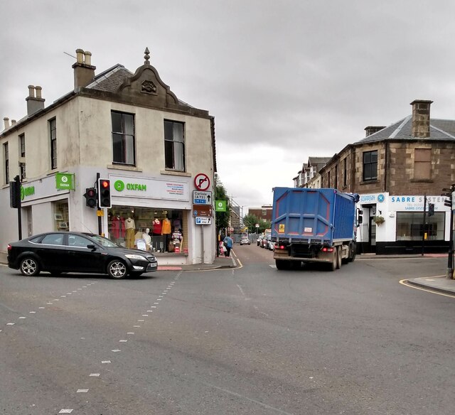
Swinging on to Bannantyne Street This HGV taking a wide course from St Leonard Street
Swinging on to Bannantyne Street
This HGV taking a wide course from St Leonard Street
Looking down High Street With St Nicholas Church at bottom
Looking down High Street
With St Nicholas Church at bottom
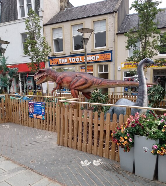
Jurassic Lanark Exhibit beside The Tolbooth, Lanark
Jurassic Lanark
Exhibit beside The Tolbooth, Lanark
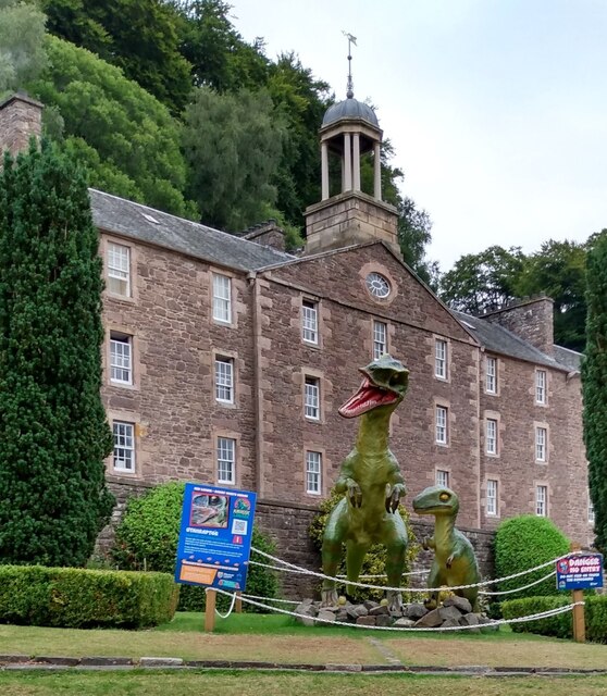
Jurassic New Lanark A trail taking in both New Lanark as well as Lanark
Jurassic New Lanark
A trail taking in both New Lanark as well as Lanark
Hillside grazing, Kirkfieldbank Brae
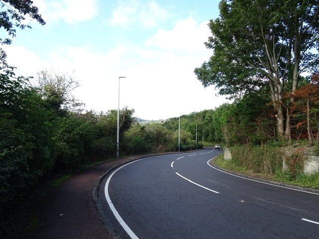
Kirkfieldbank Brae (A72) Sharply downhill towards the River Clyde.
Kirkfieldbank Brae (A72)
Sharply downhill towards the River Clyde.
Show me another place!

Bankhead is located at Grid Ref: NS8842 (Lat: 55.658565, Lng: -3.7817503)

Unitary Authority: South Lanarkshire

Police Authority: Lanarkshire

What 3 Words

///lamenting.supplied.down. Near Lanark, South Lanarkshire

Related Wikis

New Lanark

New Lanark is a village on the River Clyde, approximately 1.4 miles (2.3 kilometres) from Lanark, in Lanarkshire, and some 25 miles (40 km) southeast of...

Corehouse

Corehouse is a country house and estate, located 2 kilometres (1.2 mi) to the south of Lanark, Scotland. The estate is by the Corra Linn Falls on the River...

Corra Castle

Corra Castle (also known as Corrax, Corax or Corehouse Castle) is a ruined 16th-century castle within the Corehouse Estate near New Lanark, Scotland. It...

Falls of Clyde (waterfalls)

The Falls of Clyde is the collective name of three linn (Scots: waterfalls) on the River Clyde near New Lanark, South Lanarkshire, Scotland. The Falls...

Nearby Amenities

Located within 500m of 55.658565,-3.7817503
Dunduff Linn
Source: visual survey;estimate
Waterway: waterfall
Wikidata: Q109497104
Lat/Long: 55.6608763/-3.7807999
Mill Weir Viewpoint
Tourism: viewpoint
Lat/Long: 55.659348/-3.7797551
Bench
Backrest: no
Material: wood
Lat/Long: 55.6589312/-3.7789393
Bench
Backrest: no
Material: wood
Lat/Long: 55.6576861/-3.7773841
Bench
Backrest: no
Material: wood
Lat/Long: 55.6583727/-3.7782203
Bench
Backrest: no
Material: wood
Lat/Long: 55.6586512/-3.7786116
Bench
Backrest: no
Material: wood
Lat/Long: 55.6580424/-3.7778956
Falls of Clyde Visitor Centre (Scottish Wildlife Trust)
Information: visitor_centre
Tourism: information
Lat/Long: 55.661695/-3.780383
Dundaff Linn
Place: locality
Lat/Long: 55.6610329/-3.7808785
Tourism: picnic_site
Lat/Long: 55.6617869/-3.779374
Tourism: picnic_site
Lat/Long: 55.6618154/-3.7791354
Tourism: picnic_site
Lat/Long: 55.6618839/-3.7794364
Tourism: picnic_site
Lat/Long: 55.6619851/-3.7793501
Tourism: picnic_site
Lat/Long: 55.6621439/-3.77967
Bench
Lat/Long: 55.6595539/-3.7795908
Dipper Viewpoint
Tourism: viewpoint
Lat/Long: 55.6598672/-3.7804154
Tourism: viewpoint
Lat/Long: 55.66108/-3.7804884
View above the village
Tourism: viewpoint
Lat/Long: 55.6613144/-3.7783708
Bench
Lat/Long: 55.6607821/-3.7804427
Bench
Backrest: no
Material: wood
Lat/Long: 55.6593476/-3.7794262
Waste Basket
Lat/Long: 55.6617966/-3.7792802
Waste Basket
Lat/Long: 55.6619232/-3.7793436
Grit Bin
Lat/Long: 55.6621627/-3.7798256
Waste Basket
Lat/Long: 55.662172/-3.7799812
Fixme: Incomplete survey
Lat/Long: 55.6564411/-3.7811881
Man Made: water_wheel
Source: survey
Lat/Long: 55.6628128/-3.7808876
Waterway: sluice_gate
Lat/Long: 55.6629647/-3.7806707
Leisure: picnic_table
Source: survey
Lat/Long: 55.6627106/-3.7807032
Leisure: picnic_table
Source: survey
Lat/Long: 55.6627154/-3.7807159
Leisure: picnic_table
Source: survey
Lat/Long: 55.6627348/-3.7805743
Leisure: picnic_table
Source: survey
Lat/Long: 55.6627818/-3.7806338
Leisure: picnic_table
Source: survey
Lat/Long: 55.6627968/-3.7806699
Leisure: picnic_table
Source: survey
Lat/Long: 55.6628093/-3.7807
Leisure: picnic_table
Source: survey
Lat/Long: 55.6628215/-3.7807314
Bench
Source: survey
Lat/Long: 55.6629005/-3.7809251
Leisure: picnic_table
Source: survey
Lat/Long: 55.6629097/-3.7809449
Leisure: picnic_table
Source: survey
Lat/Long: 55.6629204/-3.7809716
Leisure: picnic_table
Source: survey
Lat/Long: 55.6629411/-3.7810209
The Rural Development Trust
Addr Housename: Offices, Level 1
Addr Postcode: ML11 9DB
Addr Street: Robert Owen's School
Building: office
Lat/Long: 55.66165/-3.7800683
Corehouse
Place: hamlet
Lat/Long: 55.6550522/-3.777904
Falls of Clyde Wildlife Reserve
Information: board
Tourism: information
Lat/Long: 55.6610134/-3.7803429
Entrance: yes
Lat/Long: 55.6615172/-3.7799382
Tourism: viewpoint
Lat/Long: 55.6611647/-3.7805461
Leisure: picnic_table
Lat/Long: 55.6626833/-3.7806212
Leisure: picnic_table
Lat/Long: 55.6627079/-3.7806286
Power: pole
Lat/Long: 55.6591446/-3.7741963
Power: pole
Lat/Long: 55.6584072/-3.7747822
The data included in this document is from www.openstreetmap.org. The data is made available under ODbL.

Have you been to Bankhead?

Leave your review of Bankhead below (or comments, questions and feedback).