Moel-y-Gaer

Hill, Mountain in Denbighshire

Wales

Moel-y-Gaer

Bwlch Penbarras Looking down from the slopes of Moel Fenlli towards the Moel Famau car park. Walking these hills and going to the summit of Moel Famau (topped with the Jubilee Tower on the horizon) is very popular, especially with visitors from the Wirral and Cheshire. This is a section of the Offa's Dyke Path.
Bwlch Penbarras Credit: Eirian Evans

Moel-y-Gaer is a prominent hill located in Denbighshire, Wales. It is situated near the town of Llanbedr-Dyffryn-Clwyd, approximately 9 miles southwest of the market town of Ruthin. With an elevation of 1,857 feet (566 meters), it is classified as a Marilyn, a hill with a prominence of 492 feet (150 meters) or more.

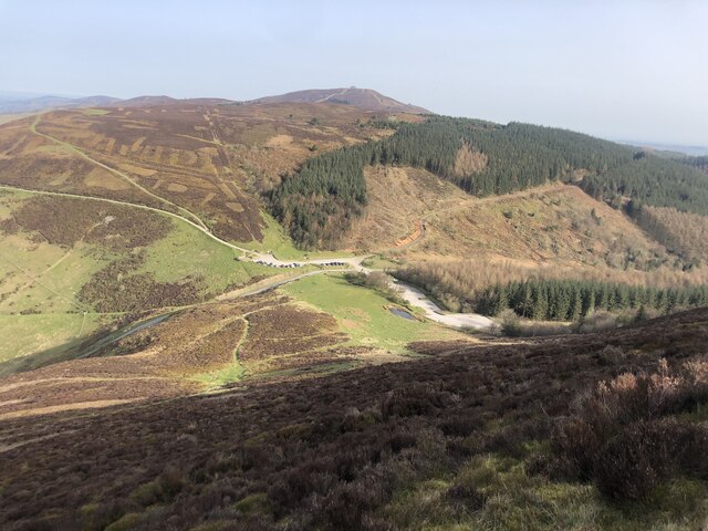
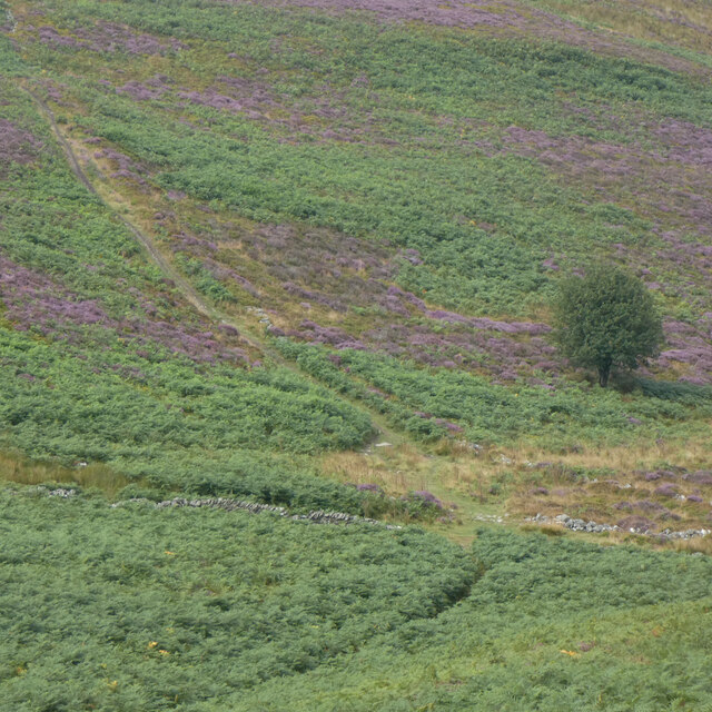
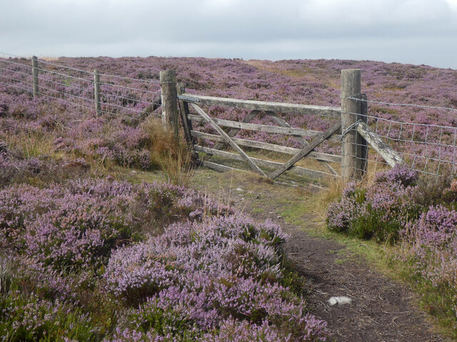
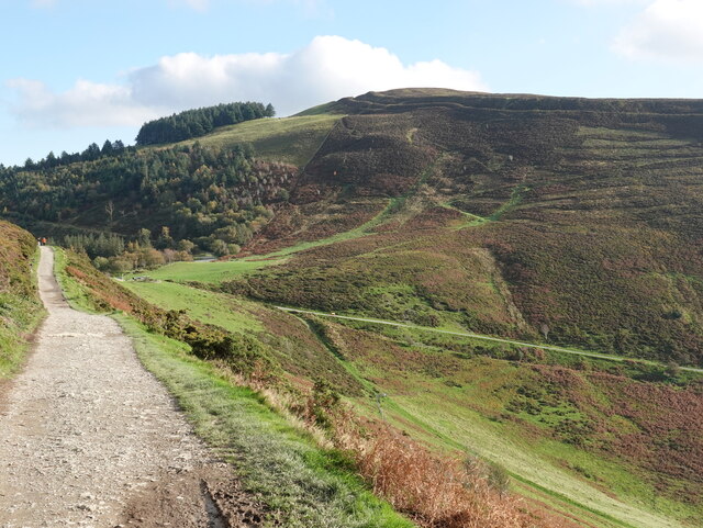
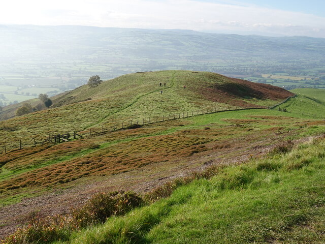
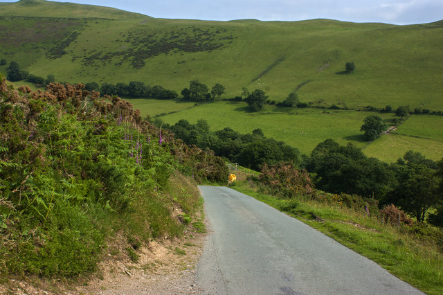
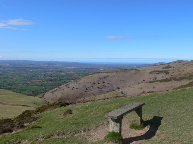
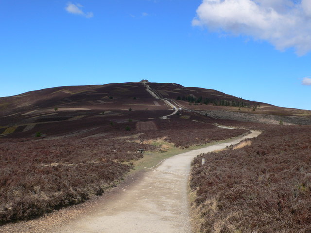
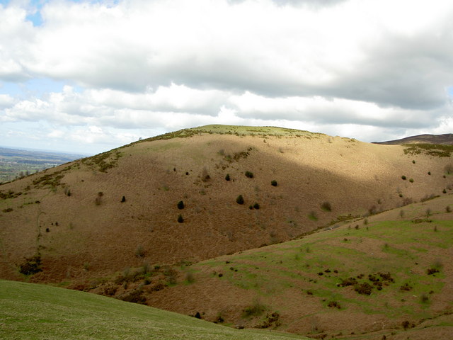
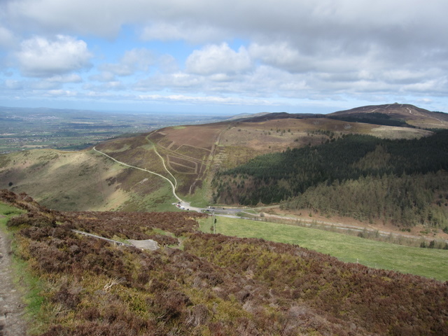
The hill offers breathtaking views of the surrounding countryside and is a popular destination for hikers and nature enthusiasts. Its location within the Clwydian Range Area of Outstanding Natural Beauty further enhances its appeal. Moel-y-Gaer is known for its diverse flora and fauna, including a variety of wildflowers, birds, and small mammals. The heather-covered slopes and rocky outcrops add to its natural beauty.

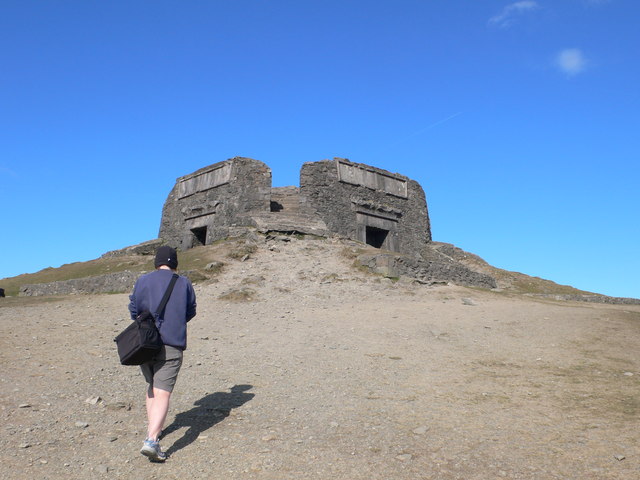
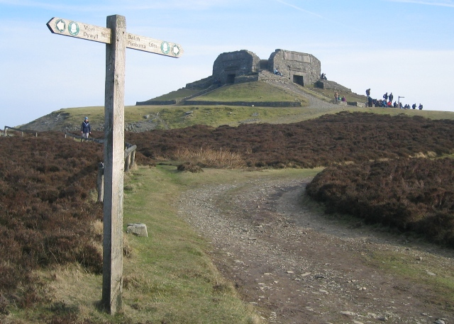
The hill is also of historical significance, with the remains of an Iron Age hillfort located at its summit. This ancient fortification, dating back to around 500 BC, was once a strategic stronghold overlooking the Clwydian Valley. The fort's circular shape and defensive ramparts can still be seen today, providing visitors with a glimpse into the region's rich past.

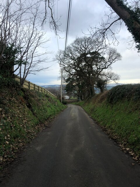
Access to Moel-y-Gaer is relatively straightforward, with several footpaths and trails leading to the summit. A popular route begins from the village of Llanbedr-Dyffryn-Clwyd, offering a moderate hike with rewarding views. The hill's proximity to other attractions in the area, such as Loggerheads Country Park and the Offa's Dyke Path, makes it a popular choice for those seeking outdoor adventures in Denbighshire.

If you have any feedback on the listing, please let us know in the comments section below.

Moel-y-Gaer Images

Images are sourced within 2km of 53.146052/-3.2737896 or Grid Reference SJ1461. Thanks to Geograph Open Source API. All images are credited.

Bwlch Penbarras Looking down from the slopes of Moel Fenlli towards the Moel Famau car park. Walking these hills and going to the summit of Moel Famau (topped with the Jubilee Tower on the horizon) is very popular, especially with visitors from the Wirral and Cheshire. This is a section of the Offa's Dyke Path.
Bwlch Penbarras
Looking down from the slopes of Moel Fenlli towards the Moel Famau car park. Walking these hills and going to the summit of Moel Famau (topped with the Jubilee Tower on the horizon) is very popular, especially with visitors from the Wirral and Cheshire. This is a section of the Offa's Dyke Path.
St Peter's Church, Llanbedr The ruined medieval church next to Llanbedr Hall, first recorded in 1254, was abandoned when the Victorian church in the modern village of Llanbedr Dyffryn Clwyd was built. This is a view of the interior where a new little altar has been installed. An occasional service is held here.
St Peter's Church, Llanbedr
The ruined medieval church next to Llanbedr Hall, first recorded in 1254, was abandoned when the Victorian church in the modern village of Llanbedr Dyffryn Clwyd was built. This is a view of the interior where a new little altar has been installed. An occasional service is held here.
Gate, Llanbedr Church As of 2021, work has been ongoing ( jointly funded by the Community Council and the Church In Wales) to preserve and restore the site. The work includes new signage & interpretation board, and these new gates as you approach the church
Gate, Llanbedr Church
As of 2021, work has been ongoing ( jointly funded by the Community Council and the Church In Wales) to preserve and restore the site. The work includes new signage & interpretation board, and these new gates as you approach the church
Pwynt tirfesur yn lliwiau'r Urdd / Trig point in Urdd colours The trig point has been painted in the colours of Urdd Gobaith Cymru, presumably due to celebrate their Eisteddfod in Denbigh in 2020.
Pwynt tirfesur yn lliwiau'r Urdd / Trig point in Urdd colours
The trig point has been painted in the colours of Urdd Gobaith Cymru, presumably due to celebrate their Eisteddfod in Denbigh in 2020.
Rheoli'r rhostir / Managing the moorland The heather cover is managed to provide suitable habitats for grouse.
Rheoli'r rhostir / Managing the moorland
The heather cover is managed to provide suitable habitats for grouse.
Llwybrau'n croesi / Crossing paths
Llidiart dan y copa / The gate below the summit
Benchmark by track below Moel Famau This benchmark is on the East face of a mountain wall, which crosses a track below Moel Famau.
Benchmark by track below Moel Famau
This benchmark is on the East face of a mountain wall, which crosses a track below Moel Famau.
Benchmark with a view to the cairn on Moel Dywyll Mountain wall with benchmark below Moel Famau, with a view to the cairn on Moel Dywyll. <a href="https://www.geograph.org.uk/photo/7269179">SJ1563 : Benchmark by track below Moel Famau</a>
Benchmark with a view to the cairn on Moel Dywyll
Mountain wall with benchmark below Moel Famau, with a view to the cairn on Moel Dywyll. SJ1563 : Benchmark by track below Moel Famau
Footpath and wall below Moel Famau Looking East along the track on the North side of Moel Famau. There is an Ordnance Survey benchmark on the other side of the tall section of wall <a href="https://www.geograph.org.uk/photo/7269179">SJ1563 : Benchmark by track below Moel Famau</a>
Footpath and wall below Moel Famau
Looking East along the track on the North side of Moel Famau. There is an Ordnance Survey benchmark on the other side of the tall section of wall SJ1563 : Benchmark by track below Moel Famau
View to Foel Fenlli across Bwlch Penbarras Looking towards the hill fort of Foel Fenlli from the popular tourist track to Moel Famau.
View to Foel Fenlli across Bwlch Penbarras
Looking towards the hill fort of Foel Fenlli from the popular tourist track to Moel Famau.
Footpath to Fron-bellaf from Offas Dyke path The highpoint in view, accessed by the footpath, looks as though it ought to be a hillfort, however, the hillfort Moel y Gaer is larger and a bit further to the north.
Footpath to Fron-bellaf from Offas Dyke path
The highpoint in view, accessed by the footpath, looks as though it ought to be a hillfort, however, the hillfort Moel y Gaer is larger and a bit further to the north.
Sunken road at Hirwaen The road goes south-west from the village to eventually join the B5429
Sunken road at Hirwaen
The road goes south-west from the village to eventually join the B5429
Barns at Tyddyn Tlodion
A road to take carefully
View from the Moel Famau path Looking northward down the Vale of Clwyd towards Liverpool Bay in the distance. In the middle is an old iron age hillfort.
View from the Moel Famau path
Looking northward down the Vale of Clwyd towards Liverpool Bay in the distance. In the middle is an old iron age hillfort.
The path from Bwlch Pen Barras to Moel Famau On top of the hill is the Jubilee Tower, built about 1810 to commemorate the fiftieth anniversary of George III's reign, the upper stages of which were blown down in a gale in 1862.
The path from Bwlch Pen Barras to Moel Famau
On top of the hill is the Jubilee Tower, built about 1810 to commemorate the fiftieth anniversary of George III's reign, the upper stages of which were blown down in a gale in 1862.
Jubilee Tower, Moel Famau. The tower was built about 1810 to commemorate the fiftieth anniversary of George III's reign, the upper stages of which were blown down in a gale in 1862.
Jubilee Tower, Moel Famau.
The tower was built about 1810 to commemorate the fiftieth anniversary of George III's reign, the upper stages of which were blown down in a gale in 1862.
Show me another place!

Moel-y-Gaer is located at Grid Ref: SJ1461 (Lat: 53.146052, Lng: -3.2737896)

Unitary Authority: Denbighshire

Police Authority: North Wales

What 3 Words

///polo.airbag.flattered. Near Ruthin, Denbighshire

Nearby Locations

Moel y Gaer Moel-y-Gaer

Related Wikis

Moel y Gaer, Llanbedr

Moel y Gaer (Welsh for "bald hill of the fortress"), also known as Moel-y-Gaer Camp or Moel y Gaer Hillfort, is an Iron Age hillfort located on a western...

Llanrhydd

Llanrhydd or Llanrhudd is a parish one and a half miles south-west of Ruthin in Denbighshire, Wales; 'rhudd' being the Welsh name for 'red' – the colour...

Moel Famau

Moel Famau is the highest hill in the Clwydian Range and the highest point (county top) of the county of Flintshire in Wales (both the historic county...

Bwlch Penbarras

Bwlch Penbarras (also known as Bwlch Pen Barras, or the Old Bwlch) is a mountain pass in the Clwydian Range and Dee Valley Area of Outstanding Natural...

Related Videos

Hiking up Moel Famau

Recorded 15 July 2021 and shows my hike up Moel Famau. The highest hill in the Clwydian Range.

Hiking to A Unique Summit Tower in Wales!

Welcome back to another Hiking and Photography video! In this weeks video, I make my way across the wonderful Welsh ...

Hiking Wales - Moel Famau & The Jubilee Tower walk

Welcome to Wales!!! A rather typical wet and wild walk with additional 35-40 mph gusts for good measure. A nice 6 mile bimble ...

Hiking Moel famau,north wales clwydian range dji mavic pro

Amazing scenary walking in the clwydian range north wales. Hiking up both moel fenlli and moel famau both overlooking ...

Nearby Amenities

Located within 500m of 53.146052,-3.2737896
Moel Y Gaer
Ele: 330
Natural: peak
Source Name: OS 1:25k OOC
Lat/Long: 53.1459158/-3.2747354
Moel y Gaer Hillfort
Place: locality
Wikidata: Q6890130
Wikipedia: en:Moel y Gaer, Llanbedr
Lat/Long: 53.1462507/-3.2739612
The data included in this document is from www.openstreetmap.org. The data is made available under ODbL.

Have you been to Moel-y-Gaer?

Leave your review of Moel-y-Gaer below (or comments, questions and feedback).