Craigs Hill

Hill, Mountain in Peeblesshire

Scotland

Craigs Hill

Gallow Law Looking northwest from the A72 east of Skirling.
Gallow Law Credit: M J Richardson

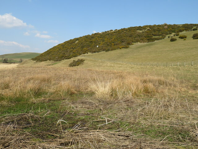
Craigs Hill is a prominent hill located in Peeblesshire, Scotland. Standing at an elevation of approximately 1,300 feet, the hill offers breathtaking panoramic views of the surrounding landscape. It is situated near the town of Peebles, approximately 23 miles south of Edinburgh.

Covered in lush green vegetation, Craigs Hill is a popular destination for outdoor enthusiasts, hikers, and nature lovers. The hill is known for its well-maintained trails, which provide various levels of difficulty for walkers of all ages and abilities. The paths meander through scenic woodlands and open moorland, offering a diverse range of flora and fauna.

As one ascends the hill, they are greeted with stunning vistas of the Tweed Valley and the rolling hills of the Scottish Borders. On clear days, it is said that one can even catch a glimpse of the famous Pentland Hills in the distance. The summit of Craigs Hill boasts an impressive viewpoint, providing an excellent opportunity for visitors to admire the natural beauty of the area.

The hill is easily accessible, with a car park located nearby, allowing visitors to embark on their journey without any hassle. Additionally, the surrounding area offers numerous amenities, including cafes, restaurants, and accommodation options, ensuring a comfortable experience for those who wish to explore Craigs Hill and its surroundings.

In summary, Craigs Hill is an outstanding natural landmark in Peeblesshire, offering stunning views, diverse hiking trails, and a chance to immerse oneself in the beauty of the Scottish countryside.

If you have any feedback on the listing, please let us know in the comments section below.

Craigs Hill Images

Images are sourced within 2km of 55.638335/-3.4556896 or Grid Reference NT0839. Thanks to Geograph Open Source API. All images are credited.

Gallow Law Looking northwest from the A72 east of Skirling.
Gallow Law
Looking northwest from the A72 east of Skirling.
Candy Burn ford and footbridge The boundary between the Scottish Borders [this side] and South Lanarkshire [across the burn]. On the road from Skirling and Cambwell to the main A702 Biggar to Edinburgh road.
Candy Burn ford and footbridge
The boundary between the Scottish Borders [this side] and South Lanarkshire [across the burn]. On the road from Skirling and Cambwell to the main A702 Biggar to Edinburgh road.
Hillside Gorse at Cambwell The hill slopes down to Candy Burn.
Hillside Gorse at Cambwell
The hill slopes down to Candy Burn.
Broughtonknowe Woods Edge of the woodland.
Broughtonknowe Woods
Edge of the woodland.
Ford and footbridge near Cambwell
A701, Stirkfield
A701, Stirkfield
Access road for Broughtonknowe The farm road with the forested hill of The Mount ahead.
Access road for Broughtonknowe
The farm road with the forested hill of The Mount ahead.
Bins, Broughton Knowe The end of a farm drive.
Bins, Broughton Knowe
The end of a farm drive.
Farm track, Broughtonknowe The entrance for Broughtonknowe and also access to the car park at the community woodland.
Farm track, Broughtonknowe
The entrance for Broughtonknowe and also access to the car park at the community woodland.
Road, Broughtonknowe View out of the wood from near the car park.
Road, Broughtonknowe
View out of the wood from near the car park.
A701, Stirkfield Commencing the descent to Broughton.
A701, Stirkfield
Commencing the descent to Broughton.
Car park entrance, Broughtonknowe Woods Broughtonknowe is a community woodland by the A701 north of Broughton. The notice advertises the Broughton Village Store and the prominent peak on the skyline is Drumelzier Law (668m).
Car park entrance, Broughtonknowe Woods
Broughtonknowe is a community woodland by the A701 north of Broughton. The notice advertises the Broughton Village Store and the prominent peak on the skyline is Drumelzier Law (668m).
Path from Broughtonknowe A path to Broughton contouring the east side of Langlaw Hill.
Path from Broughtonknowe
A path to Broughton contouring the east side of Langlaw Hill.
Sign in Broughtonknowe Woods The woodland has a network of paths on the east side of Broughton Knowe.
Sign in Broughtonknowe Woods
The woodland has a network of paths on the east side of Broughton Knowe.
Composting toilet, Broughtonknowe Woods An unexpected facility on the path below the old quarry.
Composting toilet, Broughtonknowe Woods
An unexpected facility on the path below the old quarry.
Old quarry, Broughtonknowe Woods A substantial quarry, now surrounded by the plantation. Richard Webb notes that spoil heaps from the Talla Aqueduct excavation lie here <a href="https://www.geograph.org.uk/photo/1629593">NT1039 : Spoil heap, Broughtonknowe Woods</a>. The line of the aqueduct tunnel is shown on the OS 6" sheet Peeblesshire XI.SE (1911), passing just below this quarry.

More details on the aqueduct tunnels can be found at the Canmore site <span class="nowrap"><a title="https://canmore.org.uk/site/276399/talla-reservoir-aqueduct" rel="nofollow ugc noopener" href="https://canmore.org.uk/site/276399/talla-reservoir-aqueduct">Link</a><img style="margin-left:2px;" alt="External link" title="External link - shift click to open in new window" src="https://s1.geograph.org.uk/img/external.png" width="10" height="10"/></span>
Old quarry, Broughtonknowe Woods
A substantial quarry, now surrounded by the plantation. Richard Webb notes that spoil heaps from the Talla Aqueduct excavation lie here NT1039 : Spoil heap, Broughtonknowe Woods. The line of the aqueduct tunnel is shown on the OS 6" sheet Peeblesshire XI.SE (1911), passing just below this quarry. More details on the aqueduct tunnels can be found at the Canmore site LinkExternal link
Outdoor seating, Broughtonknowe Woods The old quarry boasts what appears to be a circular wooden stage, a sofa, two armchairs and a coffee table. An outdoor theatre for a very small audience?
Outdoor seating, Broughtonknowe Woods
The old quarry boasts what appears to be a circular wooden stage, a sofa, two armchairs and a coffee table. An outdoor theatre for a very small audience?
Track below the old quarry, Broughtonknowe Woods A spell of sunshine after a prolonged shower.
Track below the old quarry, Broughtonknowe Woods
A spell of sunshine after a prolonged shower.
Show me another place!

Craigs Hill is located at Grid Ref: NT0839 (Lat: 55.638335, Lng: -3.4556896)

Unitary Authority: The Scottish Borders

Police Authority: The Lothians and Scottish Borders

What 3 Words

///region.sourcing.paid. Near Biggar, South Lanarkshire

Nearby Locations

Craigs Hill

Related Wikis

Skirling

Skirling is a parish, community council area and village in Peeblesshire in the Scottish Borders situated 2+1⁄2 miles east of Biggar in Lanarkshire. Biggar...

Brownsbank

Brownsbank (Brounsbank in Scots) is a cottage close to the small settlement of Candymill to the north of Biggar in Scotland. It is best known as the former...

Broughton Place, Scottish Borders

Broughton Place is a historic house in the village of Broughton, Scottish Borders. It was designed by Basil Spence in the style of a 17th-century Scottish...

Broughton, Scottish Borders

Broughton is a village in Tweeddale in the historical county of Peeblesshire in the Scottish Borders council area, in the south of Scotland, in the civil...

Nearby Amenities

Located within 500m of 55.638335,-3.4556896
Skirling Craigs
Place: locality
Lat/Long: 55.6376438/-3.4492282
Power: pole
Lat/Long: 55.6363895/-3.4486383
Power: pole
Lat/Long: 55.6364934/-3.4487864
Power: pole
Lat/Long: 55.6370438/-3.4495542
Power: pole
Lat/Long: 55.6369949/-3.4508848
Power: pole
Lat/Long: 55.6369602/-3.4522089
Power: pole
Lat/Long: 55.6369173/-3.4535437
Power: pole
Lat/Long: 55.6368731/-3.4550181
Power: pole
Lat/Long: 55.6368313/-3.4563909
Power: pole
Lat/Long: 55.6367919/-3.4578886
Power: pole
Lat/Long: 55.6367477/-3.4593672
Power: pole
Lat/Long: 55.6366892/-3.4608585
Power: pole
Lat/Long: 55.6366522/-3.4623435
Power: pole
Lat/Long: 55.637057/-3.4492877
Power: pole
Lat/Long: 55.6391096/-3.4633406
Power: pole
Lat/Long: 55.6383389/-3.4630274
Power: pole
Lat/Long: 55.6374685/-3.462712
The data included in this document is from www.openstreetmap.org. The data is made available under ODbL.

Have you been to Craigs Hill?

Leave your review of Craigs Hill below (or comments, questions and feedback).