Y Gaer

Hill, Mountain in Glamorgan

Wales

Y Gaer

Ordnance Survey Cut Mark This OS cut mark can be found on the barn conversion at Sheep Court Farm. It marks a point 96.299m above mean sea level.
Ordnance Survey Cut Mark Credit: Adrian Dust

Y Gaer, also known as The Gaer, is a prominent hill located in the county of Glamorgan, Wales. Standing at an elevation of approximately 185 meters (607 feet), it offers breathtaking panoramic views of the surrounding landscape. The hill is situated near the town of Cowbridge and is a popular destination for outdoor enthusiasts and nature lovers.

Y Gaer is characterized by its distinctive shape, with a gentle slope on one side and a steeper incline on the other. The hill is covered in a variety of vegetation, including grasslands, heather, and scattered trees, creating a picturesque and diverse landscape. It is also home to a wide range of wildlife, such as birds, rabbits, and small mammals.

At the summit of Y Gaer, there is a prehistoric hillfort that dates back to the Iron Age. The hillfort is surrounded by a series of impressive earthworks, including ditches and ramparts, which provide a glimpse into the ancient history of the area. Archaeological excavations have revealed evidence of human occupation on the hill dating back thousands of years.

Y Gaer is a popular destination for hikers and walkers, who can enjoy the numerous footpaths and trails that wind their way up the hill. The views from the summit are particularly stunning, offering a panoramic vista of the surrounding countryside, including nearby rolling hills, farmland, and distant mountains.

Overall, Y Gaer in Glamorgan is a captivating and historically significant hill that offers visitors a chance to immerse themselves in the natural beauty and rich heritage of the area.

If you have any feedback on the listing, please let us know in the comments section below.

Y Gaer Images

Images are sourced within 2km of 51.464173/-3.3193104 or Grid Reference ST0874. Thanks to Geograph Open Source API. All images are credited.

Ordnance Survey Cut Mark This OS cut mark can be found on the barn conversion at Sheep Court Farm. It marks a point 96.299m above mean sea level.
Ordnance Survey Cut Mark
This OS cut mark can be found on the barn conversion at Sheep Court Farm. It marks a point 96.299m above mean sea level.
Ordnance Survey Flush Bracket (S1310) This OS Flush Bracket can be found on the east angle of the Presbyterian Church. It marks a point 116.695m above mean sea level.
Ordnance Survey Flush Bracket (S1310)
This OS Flush Bracket can be found on the east angle of the Presbyterian Church. It marks a point 116.695m above mean sea level.
Ordnance Survey Rivet This OS rivet can be found on the wall south side of the road. It marks a point 122.569m above mean sea level.
Ordnance Survey Rivet
This OS rivet can be found on the wall south side of the road. It marks a point 122.569m above mean sea level.
Old Police Station
Old Police Station
Parish Church of St Nicholas A parish church comprising chancel, nave, west tower, south porch and south chapel. C14 origins. Heavily restored and extensively modified by Messrs. Parry, contractors of Llandaff from designs by and under the supervision of Messrs. Prichard and Seddon, architects of Cardiff. The restoration was completed in 1860.
The church is a Grade II* listed building.
Parish Church of St Nicholas
A parish church comprising chancel, nave, west tower, south porch and south chapel. C14 origins. Heavily restored and extensively modified by Messrs. Parry, contractors of Llandaff from designs by and under the supervision of Messrs. Prichard and Seddon, architects of Cardiff. The restoration was completed in 1860. The church is a Grade II* listed building.
St. Nicholas Postbox and Telephone box Located in the village of St. Nicholas, Vale of Glamorgan. An old red telephone box, now in use as a book repository, stands near a red, type B pillar box style postbox of the King George V era (1904 - 1936)
St. Nicholas Postbox and Telephone box
Located in the village of St. Nicholas, Vale of Glamorgan. An old red telephone box, now in use as a book repository, stands near a red, type B pillar box style postbox of the King George V era (1904 - 1936)
Ordnance Survey Cut Mark This OS cut mark can be found on NE buttress of the railway bridge. It marks a point 21.504m above mean sea level.
Ordnance Survey Cut Mark
This OS cut mark can be found on NE buttress of the railway bridge. It marks a point 21.504m above mean sea level.
Chapel Lane, south of Peterston-Super-Ely A Baptist chapel at the north end of the road gives its name to the lane
Chapel Lane, south of Peterston-Super-Ely
A Baptist chapel at the north end of the road gives its name to the lane
House entrances on Chapel Lane, Peterston-Super-Ely
Rough track to St Nicholas from Chapel Lane
Footpath to St Nicholas through woodland
Path through overhanging trees north of St Nicholas
Gate into steeply sloping field
Avenue of trees on drive to Kingsland
Approaching the Ely bridge at Peterston-Super-Ely
Railway bridge, Peterston Moors The station was originally to the left; it closed in 1964
Railway bridge, Peterston Moors
The station was originally to the left; it closed in 1964
Tinkinswood Long Cairn
Postbox by A48 at Sycamore Cross This isolated postbox is on a major road, and is close to a new housing estate on a side road; it has been sited for the convenience of postal collections
Postbox by A48 at Sycamore Cross
This isolated postbox is on a major road, and is close to a new housing estate on a side road; it has been sited for the convenience of postal collections
Show me another place!

Y Gaer is located at Grid Ref: ST0874 (Lat: 51.464173, Lng: -3.3193104)

Unitary Authority: The Vale of Glamorgan

Police Authority: South Wales

What 3 Words

///probe.coherent.deeply. Near Wenvoe, Vale of Glamorgan

Related Wikis

St. Nicholas, Vale of Glamorgan

St. Nicholas (Welsh: Sain Nicolas) is a small village in the Vale of Glamorgan, South Wales. It lies 2 miles west of the capital city, Cardiff and 7 miles...

Gwern-y-Steeple

Gwern-y-steeple is a hamlet in the Vale of Glamorgan, Wales. It lies north of the A48 road and north-west St. Nicholas (to which it is linked by Chapel...

Wyndham Park

Wydham Park (originally known as Glyn Cory Garden Village) is an uncompleted planned village in Peterston-super-Ely in the Vale of Glamorgan. It was the...
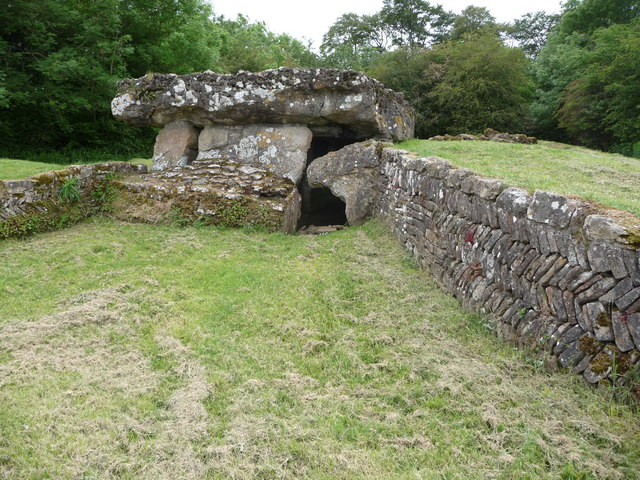
Tinkinswood

Tinkinswood or its full name Tinkinswood Burial Chamber (Welsh: Siambr Gladdu Tinkinswood), also known as Castell Carreg, Llech-y-Filiast and Maes-y-Filiast...

Nearby Amenities

Located within 500m of 51.464173,-3.3193104
Place Of Worship
Trehill Presbyterian Chapel
Denomination: presbyterian
Religion: christian
Source: http://www.stnicholasvillage.org.uk/trehill-presbyterian-church
Lat/Long: 51.4600123/-3.3166173
Crossing
Lat/Long: 51.4638554/-3.3215827
The data included in this document is from www.openstreetmap.org. The data is made available under ODbL.

Have you been to Y Gaer?

Leave your review of Y Gaer below (or comments, questions and feedback).