Cardon Hill

Hill, Mountain in Peeblesshire

Scotland

Cardon Hill

South side of Chapelgill Hill Looking over the Hope Burn from the hillside west of Congrie Hill.
South side of Chapelgill Hill Credit: Alan O'Dowd

Cardon Hill is a prominent hill located in Peeblesshire, a historic county in the southern part of Scotland. Situated approximately 3 miles southwest of Peebles town, Cardon Hill is part of the Moorfoot Hills range, which forms the boundary between Peeblesshire and Midlothian.

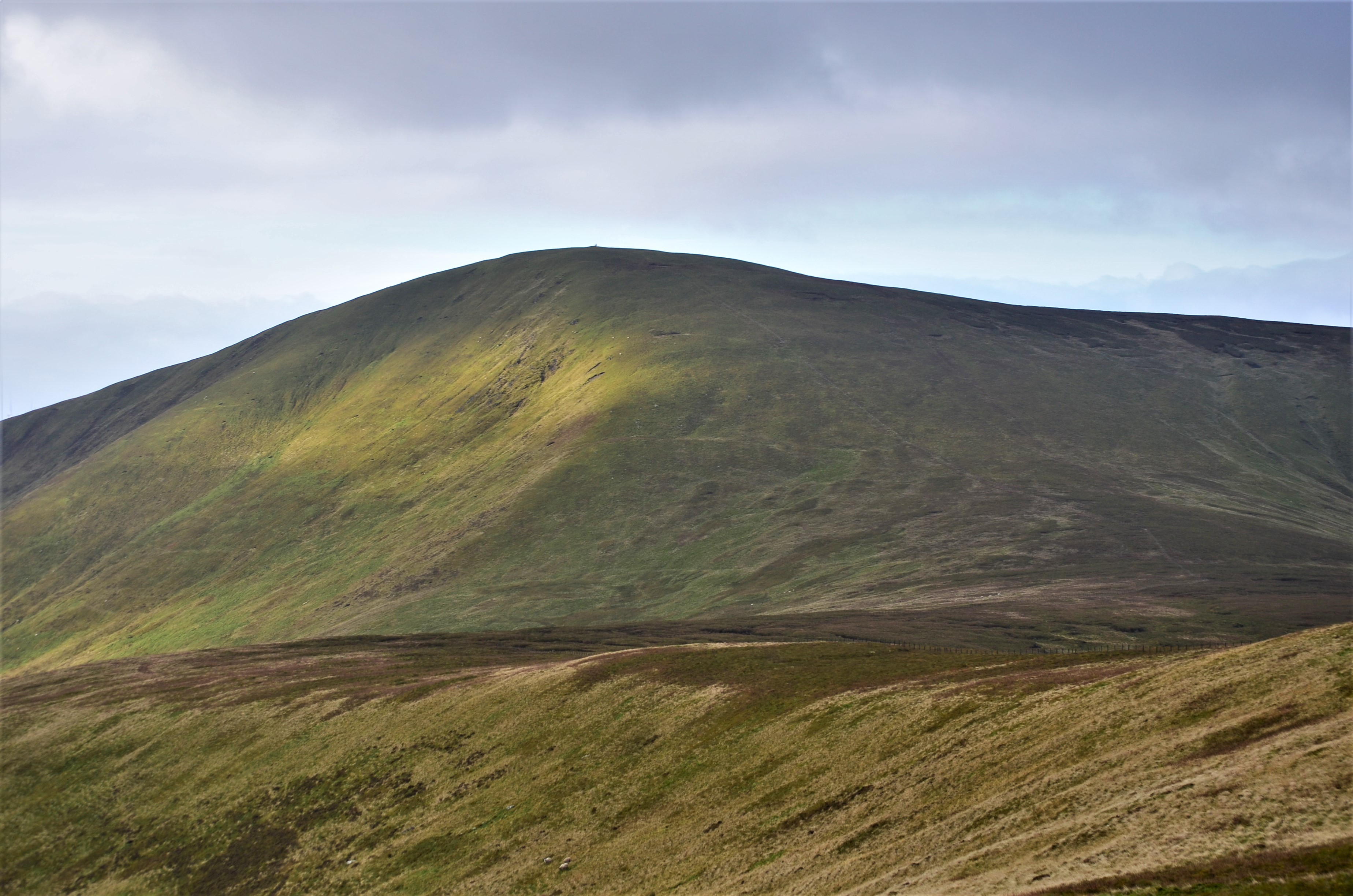
With an elevation of 580 meters (1,903 feet), Cardon Hill offers breathtaking views of the surrounding landscape. Its summit is marked by a trig point, providing a convenient reference point for hikers and surveyors. The hill is accessible via various paths and tracks, making it a popular destination for outdoor enthusiasts and walkers.

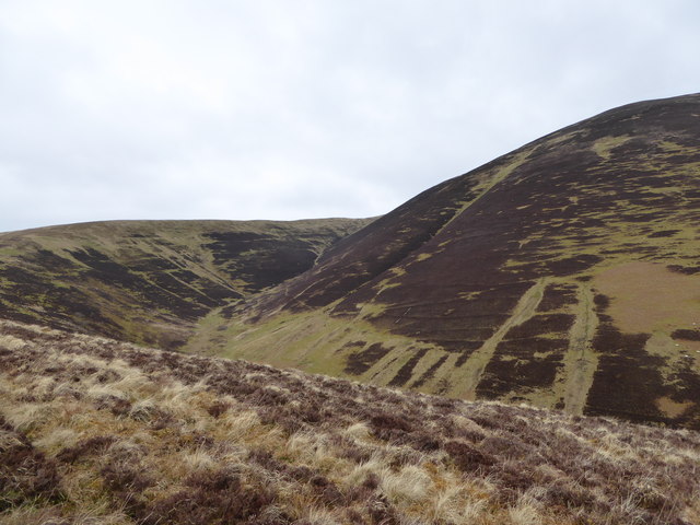
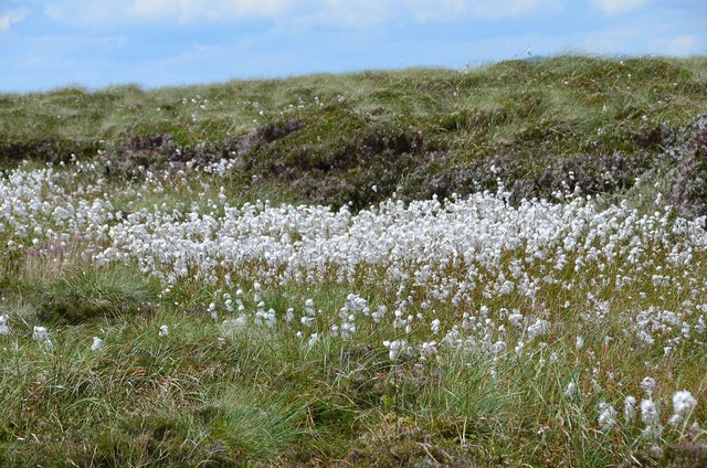
The landscape of Cardon Hill primarily consists of gently rolling hills covered in heather and grasses. The lower slopes are adorned with scattered patches of woodland, adding to the scenic beauty of the area. The hill is also home to a diverse range of wildlife, including birds, mammals, and insects, making it an ideal spot for nature lovers and birdwatchers.

Cardon Hill's location, near the town of Peebles, makes it easily accessible for both locals and tourists. The hill provides an opportunity for visitors to enjoy a peaceful retreat in nature, away from the hustle and bustle of urban life. Whether it's a leisurely stroll or a challenging hike, Cardon Hill offers something for everyone, promising a memorable experience for those who venture to its summit.

If you have any feedback on the listing, please let us know in the comments section below.

Cardon Hill Images

Images are sourced within 2km of 55.568003/-3.483821 or Grid Reference NT0631. Thanks to Geograph Open Source API. All images are credited.

South side of Chapelgill Hill Looking over the Hope Burn from the hillside west of Congrie Hill.
South side of Chapelgill Hill
Looking over the Hope Burn from the hillside west of Congrie Hill.
Chapelgill Hill from Culter Fell A view over the boggy col at Glenharvie Moss from the snow-dusted northern slope of Culter Fell.
Chapelgill Hill from Culter Fell
A view over the boggy col at Glenharvie Moss from the snow-dusted northern slope of Culter Fell.
Glenharvie Moss Crossing boggy moorland en route to Chapelgill Hill.
Glenharvie Moss
Crossing boggy moorland en route to Chapelgill Hill.
Looking across the face of Chapelgill Hill Snow-capped Tweedsdale hills in the distance.
Looking across the face of Chapelgill Hill
Snow-capped Tweedsdale hills in the distance.
Hope Burn A typical hope: steep sided with a sharp headwall, a glen going nowhere.
Hope Burn
A typical hope: steep sided with a sharp headwall, a glen going nowhere.
Ridge, Glenharvie Moss A ridge runs from Congrie Hill and Glenharvie Craigs up to the plateau at Glenharvie Moss.
Ridge, Glenharvie Moss
A ridge runs from Congrie Hill and Glenharvie Craigs up to the plateau at Glenharvie Moss.
Cotton grass on Scotland's watershed A nice display of cotton grass at Glenharvie Moss. The ridge here divides the Clyde and Tweed catchments.
Cotton grass on Scotland's watershed
A nice display of cotton grass at Glenharvie Moss. The ridge here divides the Clyde and Tweed catchments.
Hope Burn A view from the ridge to Congrie Hill with Chapelgill Hill to the left and some of the Glenkerie turbines across the glen.
Hope Burn
A view from the ridge to Congrie Hill with Chapelgill Hill to the left and some of the Glenkerie turbines across the glen.
Glenharvie Moss Looking over heathery moorland towards the eastern flank of Culter Fell.
Glenharvie Moss
Looking over heathery moorland towards the eastern flank of Culter Fell.
Chapelgill Hill View from the Glenkirk road end.
Chapelgill Hill
View from the Glenkirk road end.
Landrover track The broad ridge from Congrie Hill up to King Bank Head
Landrover track
The broad ridge from Congrie Hill up to King Bank Head
Sunset over Culter Fell Looking across the Hope Burn towards Culter Fell during the annual Chapelgill Hill Race.
Sunset over Culter Fell
Looking across the Hope Burn towards Culter Fell during the annual Chapelgill Hill Race.
Forestry, Glenhighton. There is some forestry in Glenholm, even though most of the land is used for grouse or farming. Here near the secluded house of Glenhighton is a view of typical forestry plantations. Nowadays they do not plant close to watercourses to prevent acidification.
Forestry, Glenhighton.
There is some forestry in Glenholm, even though most of the land is used for grouse or farming. Here near the secluded house of Glenhighton is a view of typical forestry plantations. Nowadays they do not plant close to watercourses to prevent acidification.
The summit of Chapelgill Hill Looking over the fence that goes right over the summit (not mentioned on OS Map), Looking towards Culter Fell.
The summit of Chapelgill Hill
Looking over the fence that goes right over the summit (not mentioned on OS Map), Looking towards Culter Fell.
King Bank Head Typical peat hag in this part of the world, with a fence leading N to Dun Knees
King Bank Head
Typical peat hag in this part of the world, with a fence leading N to Dun Knees
Pool on Glenharvie Moss Boggy pool on a boggy shoulder of Culter Fell.
Pool on Glenharvie Moss
Boggy pool on a boggy shoulder of Culter Fell.
Eastern slope of Chapelgill Hill The steep slope from Chapelgill Hill down to Glenkirk Farm in Glen Holm shows the vegetation varying from heather at the top to rough pasture and bracken as you drop down the hill.
Eastern slope of Chapelgill Hill
The steep slope from Chapelgill Hill down to Glenkirk Farm in Glen Holm shows the vegetation varying from heather at the top to rough pasture and bracken as you drop down the hill.
Middle Rig Mosaic Nice mottled colours on the lower slopes of Cardon Hill south of Biggar in the Scottish Borders.
Middle Rig Mosaic
Nice mottled colours on the lower slopes of Cardon Hill south of Biggar in the Scottish Borders.
Show me another place!

Cardon Hill is located at Grid Ref: NT0631 (Lat: 55.568003, Lng: -3.483821)

Unitary Authority: The Scottish Borders

Police Authority: The Lothians and Scottish Borders

What 3 Words

///handlebar.headset.backlog. Near Biggar, South Lanarkshire

Nearby Locations

Cardon Hill

Related Wikis

Culter Fell

Culter Fell is a hill in the Culter Hills range, part of the Southern Uplands of Scotland. It is the county top of the historic county of Lanarkshire,...

Kilbucho

Kilbucho (Scottish Gaelic: Cille Bheagha) is a small settlement in the parish of Broughton, Glenholm and Kilbucho in the Scottish Borders area of Scotland...

Coulter, South Lanarkshire

Coulter or Culter (both spellings in use, pronounced "Cooter" with no "l") is a small village and civil parish in South Lanarkshire, Scotland. It lies...

Unthank, South Lanarkshire

Unthank is a small village in South Lanarkshire, Scotland. == Note == The geographic coordinates are from the Ordnance Survey. == References ==

Nearby Amenities

Located within 500m of 55.568003,-3.483821
Cardon Hill
Ele: 675
Graham: no
Munro: no
Natural: peak
Lat/Long: 55.5682225/-3.4831372
The data included in this document is from www.openstreetmap.org. The data is made available under ODbL.

Have you been to Cardon Hill?

Leave your review of Cardon Hill below (or comments, questions and feedback).