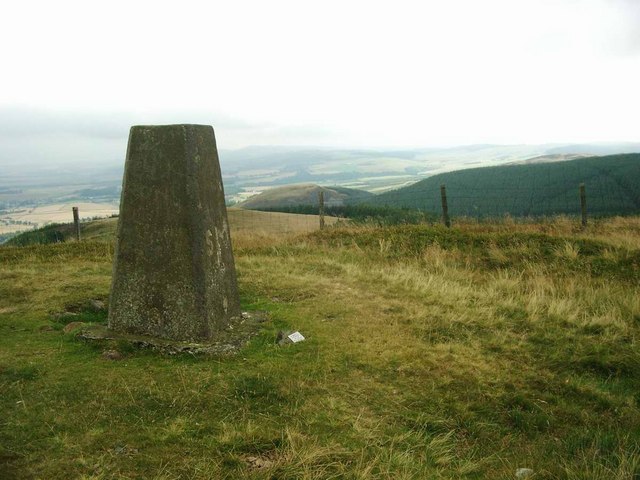
Simpleside Hill

Hill, Mountain in Perthshire

Scotland

Simpleside Hill

Head of the Lawbank Burn A marshy area surrounded by recently planted conifers.
Head of the Lawbank Burn Credit: Richard Webb

Simpleside Hill is an impressive hill located in the picturesque region of Perthshire, Scotland. Standing at an elevation of approximately 717 meters (2,352 feet), it offers breathtaking views of the surrounding area and is a significant landmark in the local landscape.

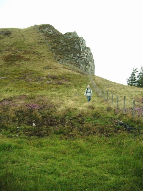
Covered in heather and scattered with granite outcrops, Simpleside Hill is a haven for outdoor enthusiasts and nature lovers. Its diverse wildlife and flora make it an ideal destination for hikers, birdwatchers, and photographers. The hill is part of the larger Ochil Hills range, which stretches across central Scotland and is known for its stunning landscapes and rich history.

Accessing Simpleside Hill is relatively straightforward, with various footpaths leading to its summit. The ascent can be challenging at times, particularly in steep sections, but the rewarding panoramic views at the top make it all worthwhile. On a clear day, visitors can see as far as the distant peaks of Ben Lawers and Schiehallion.

The hill is also steeped in history, with remnants of Iron Age forts and ancient burial sites scattered across its slopes. These archaeological sites add to the sense of intrigue and make Simpleside Hill an interesting destination for history enthusiasts.

Overall, Simpleside Hill in Perthshire is a must-visit location for those seeking a blend of natural beauty, outdoor adventure, and historical significance. Its towering presence and stunning vistas make it a memorable experience for all who venture to its summit.

If you have any feedback on the listing, please let us know in the comments section below.

Simpleside Hill Images

Images are sourced within 2km of 56.279636/-3.6238544 or Grid Reference NN9910. Thanks to Geograph Open Source API. All images are credited.

Head of the Lawbank Burn A marshy area surrounded by recently planted conifers.
Head of the Lawbank Burn
A marshy area surrounded by recently planted conifers.
A newly planted forest above the Scores Burn The moorland around Black Hill of Kippen and the Scores Burn has been planted with conifers. The new woodland appeared on the Ordnance Survey 1:50,000 map in the week after this visit.
A newly planted forest above the Scores Burn
The moorland around Black Hill of Kippen and the Scores Burn has been planted with conifers. The new woodland appeared on the Ordnance Survey 1:50,000 map in the week after this visit.
Lawbank Burn View past newly planted conifers
Lawbank Burn
View past newly planted conifers
A young plantation Most of the remaining moorland above Dunning has gone, planted with conifers. The Ochils have been the scene of a lot of conifer planting in recent years. The maps are just beginning to catch up.
A young plantation
Most of the remaining moorland above Dunning has gone, planted with conifers. The Ochils have been the scene of a lot of conifer planting in recent years. The maps are just beginning to catch up.
Road end, Piperstones Hill The end of a newly built forest road.
Road end, Piperstones Hill
The end of a newly built forest road.
Besides the Thorter Burn A new conifer plantation covering most of the former moorland between the older Rossie forest and the Dunning Glen road.
Besides the Thorter Burn
A new conifer plantation covering most of the former moorland between the older Rossie forest and the Dunning Glen road.
The glen of the Scores Burn Now forested.
The glen of the Scores Burn
Now forested.
Young conifers above the Scores Burn A new conifer plantation covering most of the former moorland between the older Rossie forest and the Dunning Glen road.
Young conifers above the Scores Burn
A new conifer plantation covering most of the former moorland between the older Rossie forest and the Dunning Glen road.
New road and plantation near Dunning A new conifer plantation covering most of the former moorland between the older Rossie forest and the Dunning Glen road.
New road and plantation near Dunning
A new conifer plantation covering most of the former moorland between the older Rossie forest and the Dunning Glen road.
New road above Dunning Almost all the remaining moorland on the north side of the Ochil Hills above Dunning has been planted with conifers. There is a network of new roads too, their exit is on the Dunning Glen road at Knowes.
New road above Dunning
Almost all the remaining moorland on the north side of the Ochil Hills above Dunning has been planted with conifers. There is a network of new roads too, their exit is on the Dunning Glen road at Knowes.
Young trees above Dunning A new conifer plantation covering most of the former moorland between the older Rossie forest and the Dunning Glen road.
Young trees above Dunning
A new conifer plantation covering most of the former moorland between the older Rossie forest and the Dunning Glen road.
Bonnie blooming heather On the northern slopes of Ben Effrey.
Bonnie blooming heather
On the northern slopes of Ben Effrey.
The trig on Craig Rossie Rossie Law, with traces of its fort, can be seen to the right of the trig.
The trig on Craig Rossie
Rossie Law, with traces of its fort, can be seen to the right of the trig.
Beld Hill and Ben Effrey Ben Effrey, on the right, shows the marks of the earthworks for the iron-age fort on its summit.
Beld Hill and Ben Effrey
Ben Effrey, on the right, shows the marks of the earthworks for the iron-age fort on its summit.
Descent from Craig Rossie Showing the cliffs on the eastern side.
Descent from Craig Rossie
Showing the cliffs on the eastern side.
Heather and Craig Rossie
Southern slopes of Beld Hill Looking into the glen of the Pairney Burn.
Southern slopes of Beld Hill
Looking into the glen of the Pairney Burn.
The Pairney Burn
The Pairney Burn
Show me another place!

Simpleside Hill is located at Grid Ref: NN9910 (Lat: 56.279636, Lng: -3.6238544)

Unitary Authority: Perth and Kinross

Police Authority: Tayside

What 3 Words

///firework.spider.freshen. Near Auchterarder, Perth & Kinross

Nearby Locations

Simpleside Hill

Related Wikis

Dunning, Perth and Kinross

Dunning is a small village in Perth and Kinross in Scotland with a population of about 1,000. The village centres around the 12th–13th century former parish...

Auchterarder railway station

Auchterarder railway station served the village of Auchterarder near Gleneagles in the Scottish county of Perth and Kinross. == History == Opened by the...

Dupplin Cross

The Dupplin Cross is a carved, monumental Pictish stone, which dates from around 800 AD. It was first recorded by Thomas Pennant in 1769, on a hillside...

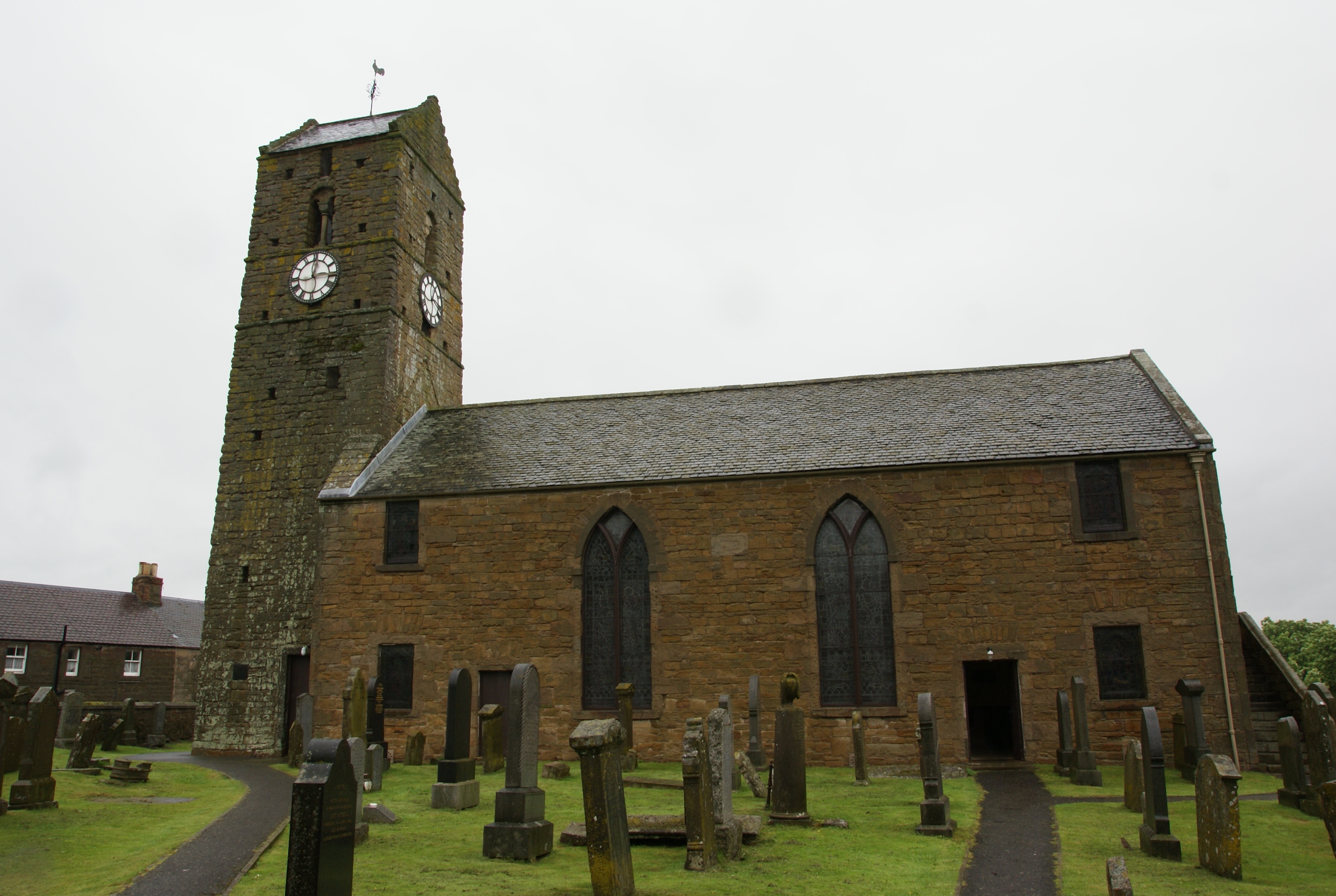
St Serf's Church, Dunning

St Serf's Church in the Scottish village of Dunning, Perth and Kinross is a Category A listed building largely dating to the early 19th century, but incorporating...

Nearby Amenities

Located within 500m of 56.279636,-3.6238544
Simpleside Hill
Ele: 433
Natural: peak
Source: NPE
Lat/Long: 56.279756/-3.624203
The data included in this document is from www.openstreetmap.org. The data is made available under ODbL.

Have you been to Simpleside Hill?

Leave your review of Simpleside Hill below (or comments, questions and feedback).