Càrn a' Mhàis Leathain
Hill, Mountain in Nairnshire
Scotland
Càrn a' Mhàis Leathain
Càrn a' Mhàis Leathain is a prominent hill located in Nairnshire, Scotland. It lies within the Cairngorms National Park, a renowned area known for its natural beauty and diverse wildlife. Standing at an elevation of 895 meters (2,936 feet), it is considered a Munro, a term used to describe Scottish mountains over 3,000 feet in height.
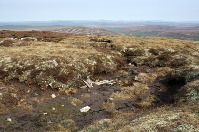
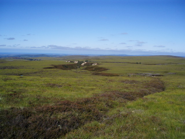
The hill is characterized by its unique landscape, featuring a mix of rocky terrain, heather-covered slopes, and scattered patches of woodland. Its summit offers panoramic views of the surrounding area, including the nearby Cairngorms range and the Moray Firth coastline.
Càrn a' Mhàis Leathain is a popular destination for hikers and outdoor enthusiasts, attracting both experienced climbers and casual walkers. There are several routes to the summit, varying in difficulty and length, allowing visitors of all fitness levels to enjoy the climb. The hill is also home to a variety of wildlife, including red deer, mountain hares, and a range of bird species, making it a haven for nature lovers and photographers.
The area surrounding Càrn a' Mhàis Leathain is rich in history and cultural heritage. The hill is often mentioned in local folklore, with stories and legends passed down through generations. Its Gaelic name translates to "hill of the broad flat-topped mass," reflecting its distinct appearance and shape.
Overall, Càrn a' Mhàis Leathain offers a spectacular outdoor experience, combining stunning vistas, challenging trails, and a chance to connect with the natural wonders of the Scottish Highlands.
If you have any feedback on the listing, please let us know in the comments section below.
Càrn a' Mhàis Leathain Images
Images are sourced within 2km of 57.445031/-3.930692 or Grid Reference NH8441. Thanks to Geograph Open Source API. All images are credited.


Càrn a' Mhàis Leathain is located at Grid Ref: NH8441 (Lat: 57.445031, Lng: -3.930692)
Unitary Authority: Highland
Police Authority: Highlands and Islands
What 3 Words
///pairings.clap.planet. Near Balloch, Highland
Nearby Locations
Related Wikis

Dun Evan
Dun Evan or the Doune of Cawdor is a hill fort located 2.5 kilometres (1.6 mi) south west of Cawdor in the Highland area of Scotland. It is situated on...

Inverness, Nairn, Badenoch and Strathspey (UK Parliament constituency)
Inverness, Nairn, Badenoch and Strathspey is a constituency of the House of Commons of the UK Parliament. As with all seats since 1950 it elects one Member...
Cawdor
Cawdor (Scottish Gaelic: Caladair) is a village and parish in the Highland council area, Scotland. The village is 5 miles (8 kilometres) south-southwest...

Cawdor (Roman fort)
Cawdor (Roman Fort), located near the small village of Easter Galcantray (15 miles or 24 kilometres east of Inverness), is suspected of being one of the...

County of Nairn
The County of Nairn (also called Nairnshire) (Scottish Gaelic: Siorrachd Inbhir Narann) is a historic county, registration county and lieutenancy area...
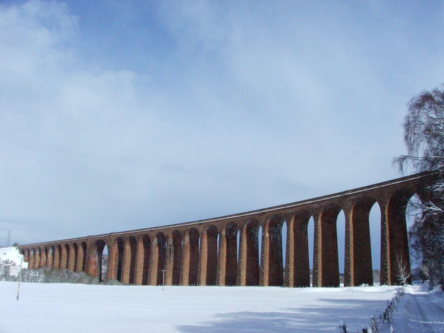
Culloden Viaduct
The Culloden Viaduct is a railway viaduct on the Highland Main Line, to the east of the city of Inverness, in the Highland council area of Scotland. It...

Cawdor Castle
Cawdor Castle is a castle in the parish of Cawdor in Nairnshire, Scotland. It is built around a 15th-century tower house, with substantial additions in...

Dunearn
Dunearn is a hill fort located 15 kilometres (9.3 mi) south south east of Nairn in Highland, Scotland. It is situated on a steep-sided hill called Doune...
Have you been to Càrn a' Mhàis Leathain?
Leave your review of Càrn a' Mhàis Leathain below (or comments, questions and feedback).