Garrow Hill

Hill, Mountain in Perthshire

Scotland

Garrow Hill

Upper Glen Shervie The upper region of Glen Shervie, with Meall nan Broighleag and Auchnafree Craig forming the western flank of the glen.
Upper Glen Shervie Credit: William Starkey

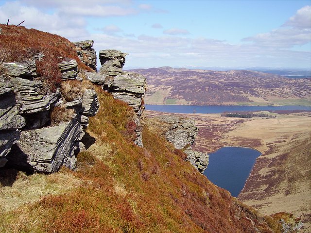
Garrow Hill is a prominent hill located in the county of Perthshire, Scotland. Situated near the town of Crieff, it is part of the picturesque countryside of the region and offers stunning views of the surrounding landscape. With an elevation of approximately 1,440 feet (439 meters), Garrow Hill is classified as a hill rather than a mountain.

The hill is known for its accessibility, making it a popular destination for outdoor enthusiasts and hikers. There are several well-marked trails leading to the summit, providing visitors with an opportunity to explore the natural beauty of the area. The trails are relatively moderate in difficulty, making Garrow Hill suitable for both experienced hikers and novices.

As one ascends the hill, they are greeted by a diverse range of flora and fauna, including heather, bracken, and various species of birds. The hill's slopes are mostly grassy, with some rocky sections nearer the summit. On clear days, the panoramic view from the top is breathtaking, encompassing rolling hills, verdant valleys, and distant peaks.

Garrow Hill is steeped in history, with archaeological remains indicating human habitation in the area dating back thousands of years. The hill is located near several ancient sites, including standing stones and burial mounds, providing a glimpse into the region's rich past.

Overall, Garrow Hill offers a rewarding outdoor experience for nature lovers and history enthusiasts alike. With its stunning views, diverse wildlife, and historical significance, it is a must-visit destination for those exploring the beautiful county of Perthshire.

If you have any feedback on the listing, please let us know in the comments section below.

Garrow Hill Images

Images are sourced within 2km of 56.517134/-3.9324757 or Grid Reference NN8137. Thanks to Geograph Open Source API. All images are credited.

Upper Glen Shervie The upper region of Glen Shervie, with Meall nan Broighleag and Auchnafree Craig forming the western flank of the glen.
Upper Glen Shervie
The upper region of Glen Shervie, with Meall nan Broighleag and Auchnafree Craig forming the western flank of the glen.
Track near Carn Bad an Fhraoich A track near to the summit of Carn Bad an Fhraoich, with Meall nan Eanchainn visibleon the skyline. An extensive network of tracks makes for easy walking in the hills above Glen Shervie.
Track near Carn Bad an Fhraoich
A track near to the summit of Carn Bad an Fhraoich, with Meall nan Eanchainn visibleon the skyline. An extensive network of tracks makes for easy walking in the hills above Glen Shervie.
Creag an Dùin Featureless terrain near Creag an Dùin, with Glen Quaich visible in the distance. The hillside is used for both sheep farming and grouse shooting, with many grouse butts in evidence.
Creag an Dùin
Featureless terrain near Creag an Dùin, with Glen Quaich visible in the distance. The hillside is used for both sheep farming and grouse shooting, with many grouse butts in evidence.
Track near Carn Bad an Fhraoich A track descending into Glen Shervie from Carn Bad an Fhraoich, with the glaciated flank of Auchnafree Craig visible towards the right of the image.
Track near Carn Bad an Fhraoich
A track descending into Glen Shervie from Carn Bad an Fhraoich, with the glaciated flank of Auchnafree Craig visible towards the right of the image.
Glen Shervie A track descending into Glen Shervie from the hills surrounding Meall nan Eanchainn
Glen Shervie
A track descending into Glen Shervie from the hills surrounding Meall nan Eanchainn
Cairns on the summit of Carn Bad an Fhraoich
Garrow Hill A view from the summit area of Garrow Hill towards the north top of Meall nan Fuaran.
Garrow Hill
A view from the summit area of Garrow Hill towards the north top of Meall nan Fuaran.
Meall nan Fuaran A view to the north towards Glen Quaich from the summit area of Meall nan Fuaran.
Meall nan Fuaran
A view to the north towards Glen Quaich from the summit area of Meall nan Fuaran.
On the north ridge of Càrn Bad an Fhraoich Looking up a moorland ridge to a snow wreath between Càrn Bad an Fhraoich and Meall nan Eanchainn on the headwall of Coire nan Gabhar.
On the north ridge of Càrn Bad an Fhraoich
Looking up a moorland ridge to a snow wreath between Càrn Bad an Fhraoich and Meall nan Eanchainn on the headwall of Coire nan Gabhar.
North ridge of Càrn Bad an Fhraoich A broad peaty ridge.
North ridge of Càrn Bad an Fhraoich
A broad peaty ridge.
Moorland on the north top of Meall nam Fuaran Gentle moorland with numerous new cross drains falling to Coire Caol.
Moorland on the north top of Meall nam Fuaran
Gentle moorland with numerous new cross drains falling to Coire Caol.
North top of Meall nam Fuaran Taken from the flat north summit of Meall nam Fuaran. Moorland falls away gently to the northern side of the hill. This side has little remaining peat.
North top of Meall nam Fuaran
Taken from the flat north summit of Meall nam Fuaran. Moorland falls away gently to the northern side of the hill. This side has little remaining peat.
Garrow Hill A hare perched on the edge of a steep slope with a view towards Garrow Hill.
Garrow Hill
A hare perched on the edge of a steep slope with a view towards Garrow Hill.
Garrow Hill The peat covered north ridge of Garrow Hill. The ridge is rounded and gently contoured.
Garrow Hill
The peat covered north ridge of Garrow Hill. The ridge is rounded and gently contoured.
Càrn Bad an Fhraoich Stone men on the horizon. The cairns are built next to an outcrop of the flat, easily split stone that makes up these hills.
Càrn Bad an Fhraoich
Stone men on the horizon. The cairns are built next to an outcrop of the flat, easily split stone that makes up these hills.
Below Coire na Slait This part of the moor is grassy and has numerous cross drains. There were a lot of ewes and lambs grazing here. Taken from the road below Garrow Hill.
Below Coire na Slait
This part of the moor is grassy and has numerous cross drains. There were a lot of ewes and lambs grazing here. Taken from the road below Garrow Hill.
Dubh Allt, Glen Quaich Looking down stream from near a pair of bridges. Moorland and rough grazing for sheep and deer under a dark sky. It was a hot and humid day with the feel of a tropical afternoon. I got down before the electrical storms started.
Dubh Allt, Glen Quaich
Looking down stream from near a pair of bridges. Moorland and rough grazing for sheep and deer under a dark sky. It was a hot and humid day with the feel of a tropical afternoon. I got down before the electrical storms started.
Col, Meall nam Fuaran A peaty col between the two rounded summits of Meall nam Fuaran.
Col, Meall nam Fuaran
A peaty col between the two rounded summits of Meall nam Fuaran.
Show me another place!

Garrow Hill is located at Grid Ref: NN8137 (Lat: 56.517134, Lng: -3.9324757)

Unitary Authority: Perth and Kinross

Police Authority: Tayside

What 3 Words

///dividing.asking.schooling. Near Aberfeldy, Perth & Kinross

Nearby Locations

Garrow Hill

Related Wikis

Glen Quaich

Glen Quaich is a glen in Perth and Kinross and is situated almost midway between Crieff and Aberfeldy. The upper reaches of the glen approach Loch Tay...

Perthshire

Perthshire (locally: ; Scottish Gaelic: Siorrachd Pheairt), officially the County of Perth, is a historic county and registration county in central Scotland...

Stirling (council area)

The Stirling council area (Scots: Stirlin; Scottish Gaelic: Sruighlea) is one of the 32 council areas of Scotland, and has a population of about 93,470...

Loch Freuchie

Loch Freuchie, also known as Fraoch, the heatherly loch, is a large freshwater loch on a north-west to south-east orientation, within Glen Quaich in Perth...

Nearby Amenities

Located within 500m of 56.517134,-3.9324757
Ele: 732
Natural: peak
Lat/Long: 56.5175078/-3.9321535
The data included in this document is from www.openstreetmap.org. The data is made available under ODbL.

Have you been to Garrow Hill?

Leave your review of Garrow Hill below (or comments, questions and feedback).