Cnoc an Fhradhairc

Hill, Mountain in Inverness-shire

Scotland

Cnoc an Fhradhairc

Forestry extraction near Carn Dearg, Glenfeshie Indicated as a single track on OS, a large vehicular track now exists for tree extraction / planting (pictured).
Forestry extraction near Carn Dearg, Glenfeshie Credit: Kim McGillivray

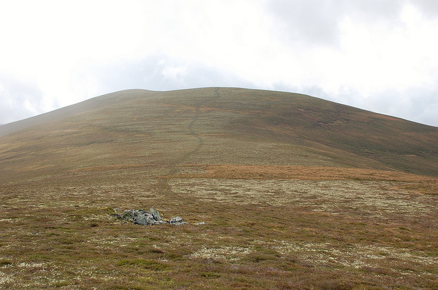
Cnoc an Fhradhairc is a hill located in Inverness-shire, Scotland. It stands at an elevation of 394 meters (1293 feet) above sea level and is a popular destination for hikers and outdoor enthusiasts. The hill offers stunning panoramic views of the surrounding countryside, including nearby Loch Ness.

Cnoc an Fhradhairc is known for its rugged terrain, with rocky outcrops and steep slopes making it a challenging but rewarding climb. The hill is covered in heather and grasses, providing habitat for a variety of wildlife including red deer, birds of prey, and small mammals.

The summit of Cnoc an Fhradhairc is marked by a cairn, which serves as a focal point for hikers reaching the top. On a clear day, visitors can see for miles around, taking in the beauty of the Scottish Highlands.

Access to Cnoc an Fhradhairc is typically via well-marked footpaths, making it accessible to hikers of all skill levels. The hill is a popular spot for both locals and tourists looking to experience the natural beauty of the Scottish countryside.

If you have any feedback on the listing, please let us know in the comments section below.

Cnoc an Fhradhairc Images

Images are sourced within 2km of 56.979462/-3.9579161 or Grid Reference NN8189. Thanks to Geograph Open Source API. All images are credited.

Forestry extraction near Carn Dearg, Glenfeshie Indicated as a single track on OS, a large vehicular track now exists for tree extraction / planting (pictured).
Forestry extraction near Carn Dearg, Glenfeshie
Indicated as a single track on OS, a large vehicular track now exists for tree extraction / planting (pictured).
Forestry track near Carn Dearg, above Glenfeshie Indicated as single track on OS maps, a vehicular track now exists for nearby forestry activities.
Forestry track near Carn Dearg, above Glenfeshie
Indicated as single track on OS maps, a vehicular track now exists for nearby forestry activities.
Watershed between Glenfeshie & Glen Tromie Looking south towards An Eilrig summit, from forestry track.
Watershed between Glenfeshie & Glen Tromie
Looking south towards An Eilrig summit, from forestry track.
Moorland,  Allt Coire Bhran Attempting to follow the faint traces of the Minigaig road. Many who cross the pass take a drier and easier route from Leathad an Taobhain to Glen Feshie rather than this difficult going towards Glen Tromie.
Moorland, Allt Coire Bhran
Attempting to follow the faint traces of the Minigaig road. Many who cross the pass take a drier and easier route from Leathad an Taobhain to Glen Feshie rather than this difficult going towards Glen Tromie.
Minigaig road The old trackway is clear along the Allt Bhran. It is still very rough and becomes indistinct higher up to the south. For some reason this northern part of the pass is less worn than the Atholl approaches: less bagging traffic or the ability to take an easier route to Glen Feshie from the summit?
Minigaig road
The old trackway is clear along the Allt Bhran. It is still very rough and becomes indistinct higher up to the south. For some reason this northern part of the pass is less worn than the Atholl approaches: less bagging traffic or the ability to take an easier route to Glen Feshie from the summit?
Feith an Dubh-chadha Blanket peat bog above the Allt Bhran. As the name suggests there is a pass at the head of the burn, but the mapped path to the north of it has serious existence issues. Most land around here is hard to cross.
Feith an Dubh-chadha
Blanket peat bog above the Allt Bhran. As the name suggests there is a pass at the head of the burn, but the mapped path to the north of it has serious existence issues. Most land around here is hard to cross.
Minigaig road, Feith an Dubh-chadha Travelling northwards, I was now finding the going easier as I followed the Allt Bhran downstream. The path still fades in and out of existence and has its rough bits but the wide flood cleared strip beside the burn often allowed easy progress. On foot this section is easy.
Minigaig road, Feith an Dubh-chadha
Travelling northwards, I was now finding the going easier as I followed the Allt Bhran downstream. The path still fades in and out of existence and has its rough bits but the wide flood cleared strip beside the burn often allowed easy progress. On foot this section is easy.
Starting to climb the big hill Starting to climb to the highest point of the Minigaig, Leathad an Taobhain, where the track rises to 830 metres.
Starting to climb the big hill
Starting to climb to the highest point of the Minigaig, Leathad an Taobhain, where the track rises to 830 metres.
Deer on a hillside It's only when you catch the movement out the side of your eye that you realise the deer that have probably watched you for the last 20 minutes, are now well beyond decent photo distance.
Deer on a hillside
It's only when you catch the movement out the side of your eye that you realise the deer that have probably watched you for the last 20 minutes, are now well beyond decent photo distance.
Allt Coire Bhran
Allt Coire Bhran
It's raining again - oops, hand shielding lens in shot Looking back down the hill where the track is now a stream again.
It's raining again - oops, hand shielding lens in shot
Looking back down the hill where the track is now a stream again.
Forestry block with Carn Dearg in the background
Hill track above Meur Mheadonach View to N, with Carn Dearg Mor beyond
Hill track above Meur Mheadonach
View to N, with Carn Dearg Mor beyond
Track through Slochd Mor to Glen Feshie Track between Glen Tromie to Glenfeshie, rideable by bicycle.
Track through Slochd Mor to Glen Feshie
Track between Glen Tromie to Glenfeshie, rideable by bicycle.
Looking up Feith an Dhub Chada
Onwards and upwards - keeping the river to the right.
On the right road At last, the deer/sheep prints I'd been following along the narrow track now has boot marks as well.
On the right road
At last, the deer/sheep prints I'd been following along the narrow track now has boot marks as well.
How far have I come now then? Looking back down towards Glen Tromie, the apparent lightening of the sky was a short lived hope. The rain and wind would soon be back.
How far have I come now then?
Looking back down towards Glen Tromie, the apparent lightening of the sky was a short lived hope. The rain and wind would soon be back.
Show me another place!

Cnoc an Fhradhairc is located at Grid Ref: NN8189 (Lat: 56.979462, Lng: -3.9579161)

Unitary Authority: Highland

Police Authority: Highlands and Islands

What 3 Words

///theory.friend.loves. Near Kingussie, Highland

Nearby Locations

Cnoc an Fhradhairc

Related Wikis

Càrn Dearg Mòr

Carn Dearg Mor (857 m) is a mountain in the Grampian Mountains of Scotland. It lies in the Badenoch and Strathspey area of Inverness-shire, east of the...

Kingdom of Scotland

The Kingdom of Scotland (Scottish Gaelic: Rìoghachd na h-Alba; Scots: Kinrick o Scotland, Norn: Kongungdum Skotland) was a sovereign state in northwest...

Scotland

Scotland (Scots: Scotland; Scottish Gaelic: Alba) is a country that is part of the United Kingdom. It contains nearly one-third of the United Kingdom's...

Battle of Craig Cailloch

The Battle of Craig Cailloch was a Scottish clan battle fought in 1441 between the Clan Cameron and Clan Mackintosh (who were part of the Chattan Confederation...

Have you been to Cnoc an Fhradhairc?

Leave your review of Cnoc an Fhradhairc below (or comments, questions and feedback).