Corringdon Ball

Hill, Mountain in Devon South Hams

England

Corringdon Ball

Old Boundary Marker or Wayside Cross between Piles Hill and Ugborough Beacon Parish Boundary Marker called Hobajohn's Cross on moorland 400 metres southwest of Piles Hill. On the boundary of Harford and Ugborough parishes. A Scheduled Monument details <span class="nowrap"><a title="https://historicengland.org.uk/listing/the-list/list-entry/1012486" rel="nofollow ugc noopener" href="https://historicengland.org.uk/listing/the-list/list-entry/1012486">Link</a><img style="margin-left:2px;" alt="External link" title="External link - shift click to open in new window" src="https://s1.geograph.org.uk/img/external.png" width="10" height="10"/></span>. See also <a title="https://www.geograph.org.uk/photo/2618013," href="https://www.geograph.org.uk/photo/2618013,">Link</a> <a title="https://www.geograph.org.uk/photo/1756182" href="https://www.geograph.org.uk/photo/1756182">Link</a> and <a title="https://www.geograph.org.uk/photo/1130015" href="https://www.geograph.org.uk/photo/1130015">Link</a>.

Milestone Society National ID: DV_HFUG05pb
Old Boundary Marker or Wayside Cross between Piles Hill and Ugborough Beacon Credit: A Rosevear

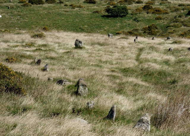
Corringdon Ball is a prominent hill located in the county of Devon, England. With an elevation of 320 meters (1,050 feet), it is often referred to as Corringdon Hill or Corringdon Beacon. The hill is situated in the southern edge of Dartmoor National Park, offering stunning panoramic views of the surrounding countryside.

Known for its distinctive conical shape, Corringdon Ball is a popular destination for hikers, nature enthusiasts, and photographers. The hill is covered in a patchwork of vibrant green fields and scattered with granite outcrops, adding to its picturesque appeal. Its summit provides an excellent vantage point from which to observe the rolling hills, wooded valleys, and charming villages that make up the Devonshire landscape.

The hill also holds historical significance, as it was once used as a beacon site during times of conflict. In the past, fires were lit on its summit to signal warnings or rally troops. Today, the remnants of these beacons can still be seen, serving as a reminder of the hill's role in the area's history.

Corringdon Ball is easily accessible, with various footpaths leading to its summit. The surrounding area offers ample parking and picnic spots for visitors to enjoy. It is advisable to bring appropriate walking gear, as the ascent can be steep in some sections.

Overall, Corringdon Ball stands as a scenic and historically significant hill, attracting visitors who seek natural beauty and a glimpse into Devon's past.

If you have any feedback on the listing, please let us know in the comments section below.

Corringdon Ball Images

Images are sourced within 2km of 50.433278/-3.872839 or Grid Reference SX6760. Thanks to Geograph Open Source API. All images are credited.

Old Boundary Marker or Wayside Cross between Piles Hill and Ugborough Beacon Parish Boundary Marker called Hobajohn's Cross on moorland 400 metres southwest of Piles Hill. On the boundary of Harford and Ugborough parishes. A Scheduled Monument details <span class="nowrap"><a title="https://historicengland.org.uk/listing/the-list/list-entry/1012486" rel="nofollow ugc noopener" href="https://historicengland.org.uk/listing/the-list/list-entry/1012486">Link</a><img style="margin-left:2px;" alt="External link" title="External link - shift click to open in new window" src="https://s1.geograph.org.uk/img/external.png" width="10" height="10"/></span>. See also <a title="https://www.geograph.org.uk/photo/2618013," href="https://www.geograph.org.uk/photo/2618013,">Link</a> <a title="https://www.geograph.org.uk/photo/1756182" href="https://www.geograph.org.uk/photo/1756182">Link</a> and <a title="https://www.geograph.org.uk/photo/1130015" href="https://www.geograph.org.uk/photo/1130015">Link</a>.

Milestone Society National ID: DV_HFUG05pb
Old Boundary Marker or Wayside Cross between Piles Hill and Ugborough Beacon
Parish Boundary Marker called Hobajohn's Cross on moorland 400 metres southwest of Piles Hill. On the boundary of Harford and Ugborough parishes. A Scheduled Monument details LinkExternal link. See also Link Link and Link. Milestone Society National ID: DV_HFUG05pb
Old Boundary Marker between Hartford Moor and Ugborough Moor Parish Boundary Marker along a line of boundary stones on a moorland track, once a tramway, between Hartford Moor and Ugborough Moor. Inscribed U and H on opposite faces and on the boundary of Ugborough and Harford parishes. See also <a title="https://www.geograph.org.uk/photo/3169540" href="https://www.geograph.org.uk/photo/3169540">Link</a>.

Milestone Society National ID: DV_HFUG01pb
Old Boundary Marker between Hartford Moor and Ugborough Moor
Parish Boundary Marker along a line of boundary stones on a moorland track, once a tramway, between Hartford Moor and Ugborough Moor. Inscribed U and H on opposite faces and on the boundary of Ugborough and Harford parishes. See also Link. Milestone Society National ID: DV_HFUG01pb
Longstone, Piles Hill
Brent Fore Hill prehistoric stone row A double prehistoric stone row measuring 120m long, including at least 32 small and medium-sized stones. The row is orientated north east to south west and there is a kerbed cairn at the upper north eastern end. <span class="nowrap"><a title="https://stonerows.wordpress.com/gazetteer/region/dartmoor/brent-fore-hill/" rel="nofollow ugc noopener" href="https://stonerows.wordpress.com/gazetteer/region/dartmoor/brent-fore-hill/">Link</a><img style="margin-left:2px;" alt="External link" title="External link - shift click to open in new window" src="https://s1.geograph.org.uk/img/external.png" width="10" height="10"/></span>
Brent Fore Hill prehistoric stone row
A double prehistoric stone row measuring 120m long, including at least 32 small and medium-sized stones. The row is orientated north east to south west and there is a kerbed cairn at the upper north eastern end. LinkExternal link
Corringdon Ball, North prehistoric stone row A single prehistoric stone row measuring 132m long, including at least 21 small and medium-sized stones. The row is orientated north east to south west and there is a kerbed cairn at the lower north eastern end. The large stone in the middle distance forms part of the kerbed cairn at the end of this row. The stones to the right form part of Corringdon Ball, South stone row and its terminal cairn. <span class="nowrap"><a title="https://stonerows.wordpress.com/gazetteer/region/dartmoor/corringdon-ball-north/" rel="nofollow ugc noopener" href="https://stonerows.wordpress.com/gazetteer/region/dartmoor/corringdon-ball-north/">Link</a><img style="margin-left:2px;" alt="External link" title="External link - shift click to open in new window" src="https://s1.geograph.org.uk/img/external.png" width="10" height="10"/></span>
Corringdon Ball, North prehistoric stone row
A single prehistoric stone row measuring 132m long, including at least 21 small and medium-sized stones. The row is orientated north east to south west and there is a kerbed cairn at the lower north eastern end. The large stone in the middle distance forms part of the kerbed cairn at the end of this row. The stones to the right form part of Corringdon Ball, South stone row and its terminal cairn. LinkExternal link
Corringdon Ball, South prehistoric stone row A multiple prehistoric stone row measuring 178m long, including at least 247 mainly small-sized together with some medium-sized stones arranged in at least 7 separate lines. The row is orientated north east to south west and there is a kerbed cairn at the lower north eastern end. This row is of a rare multiple row type, consisting as it does of parallel lines of stones rather than the usual fan-shaped arrangement. <span class="nowrap"><a title="https://stonerows.wordpress.com/gazetteer/region/dartmoor/corringdon-ball-south/" rel="nofollow ugc noopener" href="https://stonerows.wordpress.com/gazetteer/region/dartmoor/corringdon-ball-south/">Link</a><img style="margin-left:2px;" alt="External link" title="External link - shift click to open in new window" src="https://s1.geograph.org.uk/img/external.png" width="10" height="10"/></span>
Corringdon Ball, South prehistoric stone row
A multiple prehistoric stone row measuring 178m long, including at least 247 mainly small-sized together with some medium-sized stones arranged in at least 7 separate lines. The row is orientated north east to south west and there is a kerbed cairn at the lower north eastern end. This row is of a rare multiple row type, consisting as it does of parallel lines of stones rather than the usual fan-shaped arrangement. LinkExternal link
Glasscombe Ball prehistoric stone row A combination single and double prehistoric stone row measuring 84.5m long, including 24 recumbent stones of different sizes.  The row is orientated north east to south west and is in the vicinity of six stone rows and  several cairns. <span class="nowrap"><a title="https://stonerows.wordpress.com/gazetteer/region/dartmoor/glasscombe-ball-north/" rel="nofollow ugc noopener" href="https://stonerows.wordpress.com/gazetteer/region/dartmoor/glasscombe-ball-north/">Link</a><img style="margin-left:2px;" alt="External link" title="External link - shift click to open in new window" src="https://s1.geograph.org.uk/img/external.png" width="10" height="10"/></span>
Glasscombe Ball prehistoric stone row
A combination single and double prehistoric stone row measuring 84.5m long, including 24 recumbent stones of different sizes. The row is orientated north east to south west and is in the vicinity of six stone rows and several cairns. LinkExternal link
Glasscombe Corner prehistoric stone row A combination single and double prehistoric stone row measuring 173m long, including at least 82 small and medium-sized stones. The row is orientated north east to south west and there is a kerbed cairn at the lower north eastern end. <span class="nowrap"><a title="https://stonerows.wordpress.com/gazetteer/region/dartmoor/glasscombe-corner/" rel="nofollow ugc noopener" href="https://stonerows.wordpress.com/gazetteer/region/dartmoor/glasscombe-corner/">Link</a><img style="margin-left:2px;" alt="External link" title="External link - shift click to open in new window" src="https://s1.geograph.org.uk/img/external.png" width="10" height="10"/></span>
Glasscombe Corner prehistoric stone row
A combination single and double prehistoric stone row measuring 173m long, including at least 82 small and medium-sized stones. The row is orientated north east to south west and there is a kerbed cairn at the lower north eastern end. LinkExternal link
Corringdon Ball prehistoric enclosed settlements Prehistoric agglomerated enclosures that were probably built and lived in during the Middle Bronze Age (1400 - 1000 BC). <span class="nowrap"><a title="https://historicengland.org.uk/listing/the-list/list-entry/1010208" rel="nofollow ugc noopener" href="https://historicengland.org.uk/listing/the-list/list-entry/1010208">Link</a><img style="margin-left:2px;" alt="External link" title="External link - shift click to open in new window" src="https://s1.geograph.org.uk/img/external.png" width="10" height="10"/></span>
Corringdon Ball prehistoric enclosed settlements
Prehistoric agglomerated enclosures that were probably built and lived in during the Middle Bronze Age (1400 - 1000 BC). LinkExternal link
Corringdon Ball chambered cairn The mutilated remains of the chamber at the southern end of the mound (Scale 1m). <span class="nowrap"><a title="https://www.megalithic.co.uk/article.php?sid=4619" rel="nofollow ugc noopener" href="https://www.megalithic.co.uk/article.php?sid=4619">Link</a><img style="margin-left:2px;" alt="External link" title="External link - shift click to open in new window" src="https://s1.geograph.org.uk/img/external.png" width="10" height="10"/></span>
Corringdon Ball chambered cairn
The mutilated remains of the chamber at the southern end of the mound (Scale 1m). LinkExternal link
Gates by lane above Aish On the no through lane towards Aish Ridge.
Gates by lane above Aish
On the no through lane towards Aish Ridge.
Track, Treeland Downs Seen from South Brent bridleway 20 near a spring that is the source of a headwater of the Badworthy Brook, hence the valley. The trees on the right are along the western edge of the access land on Aish Ridge.
Track, Treeland Downs
Seen from South Brent bridleway 20 near a spring that is the source of a headwater of the Badworthy Brook, hence the valley. The trees on the right are along the western edge of the access land on Aish Ridge.
Approaching Ball Gate From the open moor. South Brent bridleway 18 arrives from the left; after passing through the gate it becomes South Brent bridleway 20.
Approaching Ball Gate
From the open moor. South Brent bridleway 18 arrives from the left; after passing through the gate it becomes South Brent bridleway 20.
Private track to barn near Zeal The barn is also seen in <a href="https://www.geograph.org.uk/photo/3030332">SX6762 : Grass field nr Zeal</a>.
Private track to barn near Zeal
The barn is also seen in SX6762 : Grass field nr Zeal.
Bridleway, Overbrent Wood South Brent bridleway 13 runs along the northern edge of the wood.
Bridleway, Overbrent Wood
South Brent bridleway 13 runs along the northern edge of the wood.
Farmland, Aish Not sure what's kept here; bees, hens ...? Anyway, they seem to need a scarecrow.
Farmland, Aish
Not sure what's kept here; bees, hens ...? Anyway, they seem to need a scarecrow.
Field near Aish From the no through road that leads towards Aish Ridge.
Field near Aish
From the no through road that leads towards Aish Ridge.
Lane approaching Aish The no through lane from Gribblesdown.
Lane approaching Aish
The no through lane from Gribblesdown.
Show me another place!

Corringdon Ball is located at Grid Ref: SX6760 (Lat: 50.433278, Lng: -3.872839)

Administrative County: Devon

District: South Hams

Police Authority: Devon and Cornwall

What 3 Words

///tribes.grudging.bombshell. Near South Brent, Devon

Related Wikis

Badworthy

Badworthy is a village in Devon, England.

Aish, South Brent

Aish is a relatively small hamlet in the English county of Devon. It is near the large village of South Brent. This Aish is not to be confused with the...

Lutton, South Brent

Lutton is a small farming hamlet on the outskirts of South Brent, Devon, England. It is a hillside community on the side of Brent Hill. It is only a small...

Glazebrook House, South Brent

Glazebrook House is a building of historical significance in South Brent, Devon. Part of the house was built in about 1650 and was successively added to...

South Brent

South Brent is a large village on the southern edge of Dartmoor, England, in the valley of the River Avon. The parish includes the small hamlets of Aish...

Butterdon Hill

Butterdon Hill is on Dartmoor, in southwest England. The remains of a small stone circle and a stone row can be found on the summit. The name Butterdon...

Brent Hill

Brent Hill is the site of an Iron Age hill fort situated close to South Brent in Devon, England. The fort occupies the top of Brent Hill at approx 311...
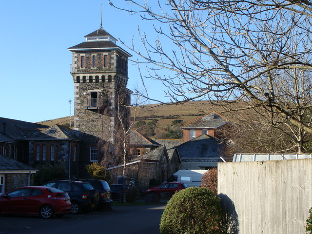
Moorhaven Hospital

Moorhaven Hospital, built as Plymouth Asylum and initially names the Plymouth Borough Asylum, was a mental health facility in Ivybridge, Devon, England...

Nearby Amenities

Located within 500m of 50.433278,-3.872839
Corringdon Ball
Natural: peak
Source: NPE
Lat/Long: 50.4335729/-3.8718974
Ford: yes
Lat/Long: 50.4359112/-3.8779673
Ford: yes
Lat/Long: 50.431871/-3.8780138
The data included in this document is from www.openstreetmap.org. The data is made available under ODbL.

Have you been to Corringdon Ball?

Leave your review of Corringdon Ball below (or comments, questions and feedback).