Meall Luaidhe

Hill, Mountain in Perthshire

Scotland

Meall Luaidhe

Peat hags at Meall nan Eun Extremely boggy area of moorland with the lower slopes of Meall nam Maigheach in the distance.
Peat hags at Meall nan Eun Credit: Iain Russell

Meall Luaidhe is a prominent hill located in Perthshire, Scotland. It is part of the Grampian Mountains and stands at an impressive height of 968 meters (3,176 feet) above sea level. The hill is situated near the village of Glen Lyon, northwest of the town of Aberfeldy.

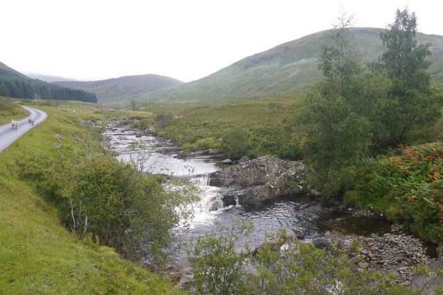
Meall Luaidhe offers breathtaking panoramic views of the surrounding landscape, including the stunning Glen Lyon valley, which is often referred to as Scotland's longest, narrowest glen. The hill is characterized by its rolling slopes and rocky terrain, making it a popular destination for hikers and mountaineers looking for a challenging climb.

The ascent to the summit of Meall Luaidhe can be demanding, particularly on the northern side, where steep slopes and scree can be encountered. However, the reward for reaching the top is well worth the effort, as it provides an unmatched vantage point to admire the beauty of the Scottish Highlands.

The hill is also renowned for its diverse flora and fauna, with heather, grasses, and wildflowers covering its slopes. Wildlife enthusiasts may have the opportunity to spot red deer, mountain hares, and various bird species during their exploration.

Meall Luaidhe is a fantastic destination for outdoor enthusiasts seeking a taste of Scotland's rugged natural beauty. Whether it's for hiking, photography, or simply enjoying the tranquility of the mountains, this majestic hill offers an unforgettable experience for visitors of all ages and abilities.

If you have any feedback on the listing, please let us know in the comments section below.

Meall Luaidhe Images

Images are sourced within 2km of 56.564404/-4.3097654 or Grid Reference NN5843. Thanks to Geograph Open Source API. All images are credited.

Peat hags at Meall nan Eun Extremely boggy area of moorland with the lower slopes of Meall nam Maigheach in the distance.
Peat hags at Meall nan Eun
Extremely boggy area of moorland with the lower slopes of Meall nam Maigheach in the distance.
Road looking south
Road looking south
Road looking southeast
Coire Buidhe, Meall nam Maigheach A very gentle corrie above the Lairig an Lochain. Coire Buidhes are often gentle, they are named after the dun coloured grasses and are usually popular with deer.
Coire Buidhe, Meall nam Maigheach
A very gentle corrie above the Lairig an Lochain. Coire Buidhes are often gentle, they are named after the dun coloured grasses and are usually popular with deer.
Allt Baile a' Mhuilinn The Lyon side of the Lairig an Lochain.  The burn descends to the Lyon near Bridge of Balgie with Ben Meggernie in the background.
Allt Baile a' Mhuilinn
The Lyon side of the Lairig an Lochain. The burn descends to the Lyon near Bridge of Balgie with Ben Meggernie in the background.
Allt Baile a' Mhuilinn A burn draining the north side of the Tarmachan range into Glen Lyon. Like many of the Lyon side glens there were many shielings here.
Allt Baile a' Mhuilinn
A burn draining the north side of the Tarmachan range into Glen Lyon. Like many of the Lyon side glens there were many shielings here.
Allt Baile a' Mhuilinn / Allt Breisleich The meeting of the Allt Breisleich and Allt Baile a' Mhuilinn.  This is also where two passes either side of the Tarmachan range meet. One, Lairg an Lochain has a modern road, the other, Lairig Breisleich is almost forgotten, trackless and boggy.
Allt Baile a' Mhuilinn / Allt Breisleich
The meeting of the Allt Breisleich and Allt Baile a' Mhuilinn. This is also where two passes either side of the Tarmachan range meet. One, Lairg an Lochain has a modern road, the other, Lairig Breisleich is almost forgotten, trackless and boggy.
East side of Meall Luaidhe Steep rocky ground above Glen Lyon.
East side of Meall Luaidhe
Steep rocky ground above Glen Lyon.
Cattle grid, Lairig an Lochain The road between Bridge of Balgie in Glen Lyon and Loch Tay.
Cattle grid, Lairig an Lochain
The road between Bridge of Balgie in Glen Lyon and Loch Tay.
Allt Baile a' Mhuilinn Looking upstream from the Lairg an Lochain road in Glen Lyon.
Allt Baile a' Mhuilinn
Looking upstream from the Lairg an Lochain road in Glen Lyon.
Meall nam Maigheach A 779m high hill on the south side of Glen Lyon.  Normally ascended by an easy stroll from the Lochan na Lairig road ( I set out at nearly 4pm in late Autumn and got down in daylight), it presents a better appearance to Gleann Dà-Eig.
Meall nam Maigheach
A 779m high hill on the south side of Glen Lyon. Normally ascended by an easy stroll from the Lochan na Lairig road ( I set out at nearly 4pm in late Autumn and got down in daylight), it presents a better appearance to Gleann Dà-Eig.
Gleann Dà-Eig Under the corrie of Meall nam Maigheach.  The lower and middle of the glen are not as well visited as its head which is on a munro bagger's trade route from the Lairig an Lochain road.
Gleann Dà-Eig
Under the corrie of Meall nam Maigheach. The lower and middle of the glen are not as well visited as its head which is on a munro bagger's trade route from the Lairig an Lochain road.
Old track, Gleann Dà-Eig A gully parallel with the current road suggests that there has been a substantial track up the glen for some time.
Old track, Gleann Dà-Eig
A gully parallel with the current road suggests that there has been a substantial track up the glen for some time.
Shieling ruin, Gleann Dà-Eig One of the many shieling ruins in the glen. There is also an old iron post and wire fence.
Shieling ruin, Gleann Dà-Eig
One of the many shieling ruins in the glen. There is also an old iron post and wire fence.
View towards Meall Corranaich The road up Gleann Da-Eig is very grassy as it approaches its end.
View towards Meall Corranaich
The road up Gleann Da-Eig is very grassy as it approaches its end.
Head of Gleann Dà-Eig Things get boggy towards the top of the glen.  There is a fair bit of traffic crossing the glen from the low pass between here and Lairig an Lochain on the way to Meall a' Choire Lèith
Head of Gleann Dà-Eig
Things get boggy towards the top of the glen. There is a fair bit of traffic crossing the glen from the low pass between here and Lairig an Lochain on the way to Meall a' Choire Lèith
Shepherds' cairn on Meall Luaidhe
Culvert under old track
Show me another place!

Meall Luaidhe is located at Grid Ref: NN5843 (Lat: 56.564404, Lng: -4.3097654)

Unitary Authority: Perth and Kinross

Police Authority: Tayside

What 3 Words

///optimists.undertook.resolves. Near Pubil, Perth & Kinross

Related Wikis

Bridge of Balgie

Bridge of Balgie is a hamlet in Glen Lyon (Perth & Kinross, Scotland) and lies at the junction between the east–west single track road along the foot of...

Glen Lyon

Glen Lyon (Scottish Gaelic: Gleann Lìomhann) is a glen in the Perth and Kinross region of Scotland. It is the longest enclosed glen in Scotland and runs...

Meggernie Castle

Meggernie Castle is a castle in the heart of Perth and Kinross, in central Scotland. It is located halfway up Glenlyon, where the river Lyon flows through...

Meall Corranaich

Meall Corranaich (Scottish Gaelic: Meall Choire Inich) is a mountain with a height of 1,069 metres (3,507 ft) in the Grampian Mountains of Scotland. It...

Nearby Amenities

Located within 500m of 56.564404,-4.3097654
Meall nam Maigheach
Corbett: yes
Description: Hill of the hares
Ele: 779
Graham: no
Marilyn: yes
Munro: no
Natural: peak
Prominence: 176
Lat/Long: 56.5630299/-4.3033742
Meall Luaidhe
Place: locality
Lat/Long: 56.5672399/-4.3084418
The data included in this document is from www.openstreetmap.org. The data is made available under ODbL.

Have you been to Meall Luaidhe?

Leave your review of Meall Luaidhe below (or comments, questions and feedback).