Beinn Udlamain

Hill, Mountain in Perthshire

Scotland

Beinn Udlamain

Summit cairn on Beinn Udlamain
Summit cairn on Beinn Udlamain Credit: Steven Brown

Beinn Udlamain is a prominent hill located in Perthshire, Scotland. With an elevation of 1,018 meters (3,340 feet), it is classified as a Munro, which means it is one of the many Scottish mountains over 3,000 feet in height.

Situated in the southern part of the Cairngorms National Park, Beinn Udlamain offers breathtaking views of the surrounding Highland landscape. It sits between two other Munros, A' Mharconaich to the west and Sgairneach Mhor to the east, forming a challenging and rewarding circuit for hikers and mountaineers.

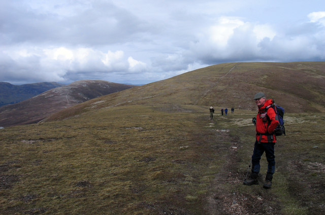
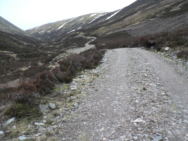
The ascent to the summit of Beinn Udlamain is characterized by a gradual incline through a mix of heather-covered moorland and rocky terrain. The route typically starts from the A9 road, near the Drumochter Pass, where a clearly marked path leads climbers up the hill. As they ascend, visitors are treated to stunning vistas of the surrounding peaks, glens, and lochs, including Loch Ericht to the north.

The summit of Beinn Udlamain offers a wide, flat plateau, providing ample space to rest and take in the panoramic views of the Cairngorms and the Grampian Mountains. On a clear day, it is possible to see as far as Ben Nevis, the highest peak in the British Isles, to the west.

Although Beinn Udlamain is a challenging hike, it is a popular destination for outdoor enthusiasts seeking to test their physical abilities and experience the natural beauty of the Scottish Highlands.

If you have any feedback on the listing, please let us know in the comments section below.

Beinn Udlamain Images

Images are sourced within 2km of 56.835461/-4.3298475 or Grid Reference NN5773. Thanks to Geograph Open Source API. All images are credited.

Summit cairn on Beinn Udlamain
Slopes of Beinn Udlamain
Ridge connecting A' Mharconaich with Beinn Udlamain The low point between the Munros A' Mharconaich and Beinn Udlamain is the obvious dip in the ridge. The ridge rises to A' Mharconaich summit of which lies out of view to the right of the image. Geal Charn is the rounded peak to the left; it's also a Munro.
Ridge connecting A' Mharconaich with Beinn Udlamain
The low point between the Munros A' Mharconaich and Beinn Udlamain is the obvious dip in the ridge. The ridge rises to A' Mharconaich summit of which lies out of view to the right of the image. Geal Charn is the rounded peak to the left; it's also a Munro.
Sgairneach Mhòr from north-east ridge of Beinn Udlamain A high, broad ridge connects the Munros of Beinn Udlamain and A' Mharconaich; there's a minor rise along the ridge at 902m from where this image was recorded. Sgairneach Mhòr is the distant mountain, also a Munro.
(Note the altered arrangement of fallen fence posts! <a title="https://www.geograph.org.uk/photo/76492" href="https://www.geograph.org.uk/photo/76492">Link</a> )
Sgairneach Mhòr from north-east ridge of Beinn Udlamain
A high, broad ridge connects the Munros of Beinn Udlamain and A' Mharconaich; there's a minor rise along the ridge at 902m from where this image was recorded. Sgairneach Mhòr is the distant mountain, also a Munro. (Note the altered arrangement of fallen fence posts! Link )
Ruined walls or pile of stones In the middle of the moorland I came across this pile of stones that appeared to be rectangular in shape that could suggest a ruined sheiling or it may just be a pile of stones
Ruined walls or pile of stones
In the middle of the moorland I came across this pile of stones that appeared to be rectangular in shape that could suggest a ruined sheiling or it may just be a pile of stones
New Access Road Ne Access road along Coire Dhomhain
New Access Road
Ne Access road along Coire Dhomhain
A Snow Bridge A patch of snow on the upper reaches of Allt Coire Dhomhain, hold right onto wet grass or make new footprints in the snow.
A Snow Bridge
A patch of snow on the upper reaches of Allt Coire Dhomhain, hold right onto wet grass or make new footprints in the snow.
Rock sculpture This little pile of rocks grabbed my attention, it reminded me of the Inukshuk I saw in the National Museum of Scotland, albeit a bit smaller.
Rock sculpture
This little pile of rocks grabbed my attention, it reminded me of the Inukshuk I saw in the National Museum of Scotland, albeit a bit smaller.
Beinn Udlamain summit cairn  Munro #61 A fantastic summit cairn, shelters and flat rocks to sit on on all sides, so at least you can get some shelter from just about any direction of wind.  The fence post sculpture I have seen in other photographs is now all piled up on the cairn.
Beinn Udlamain summit cairn Munro #61
A fantastic summit cairn, shelters and flat rocks to sit on on all sides, so at least you can get some shelter from just about any direction of wind. The fence post sculpture I have seen in other photographs is now all piled up on the cairn.
On Sgairneach Mhor South west of the summit looking towards the col near Mam Ban
On Sgairneach Mhor
South west of the summit looking towards the col near Mam Ban
Loch Ericht and Beinn Udlamain The nearest hillside is the NW slope of Beinn Udlamain in this long view from Geal-charn. Loch Ericht widens out to Alder Bay to the right. The distant hill on the left is probably Beinn Achaladair.
Loch Ericht and Beinn Udlamain
The nearest hillside is the NW slope of Beinn Udlamain in this long view from Geal-charn. Loch Ericht widens out to Alder Bay to the right. The distant hill on the left is probably Beinn Achaladair.
Schiehallion View A telephoto shot of distant Schiehallion from Beinn Udlamain across the shoulder of Sgairneach Mhor.
Schiehallion View
A telephoto shot of distant Schiehallion from Beinn Udlamain across the shoulder of Sgairneach Mhor.
Moorland above Loch Ericht Moorland in the Glas hoire above Loch Ericht, with the track running along the west side of the loch visible in the distance. Low cloud is limiting visibility, despite a heat wave allegedly occurring "down south".
Moorland above Loch Ericht
Moorland in the Glas hoire above Loch Ericht, with the track running along the west side of the loch visible in the distance. Low cloud is limiting visibility, despite a heat wave allegedly occurring "down south".
Carn 'Ic Loumhaidh A view to the north from Carn 'Ic Loumhaidh towards Beinn Udlamain.
Carn 'Ic Loumhaidh
A view to the north from Carn 'Ic Loumhaidh towards Beinn Udlamain.
View towards Geal Charn and A' Mharconaich A view taken on a descent from Beinn Udlamain towards Geal Charn and A' Mharconaich with the Fraoch-choire in the foreground - still daylight at 21:00 in early July.
View towards Geal Charn and A' Mharconaich
A view taken on a descent from Beinn Udlamain towards Geal Charn and A' Mharconaich with the Fraoch-choire in the foreground - still daylight at 21:00 in early July.
Coire Bhacaidh Steep ground in Coire Bhacaidh, viewed over the course of the Allt Udlamain, with Loch Ericht visible in the distance.
Coire Bhacaidh
Steep ground in Coire Bhacaidh, viewed over the course of the Allt Udlamain, with Loch Ericht visible in the distance.
North-western slopes of An Sgùlan The steep north-western slopes of An Sgùlan, with Beinn Udlamain visible in the distance.
North-western slopes of An Sgùlan
The steep north-western slopes of An Sgùlan, with Beinn Udlamain visible in the distance.
Coire Dhomhain The boulder strewn western flank of Sgairneach Mhòr in the upper region of Coire Dhomhain.
Coire Dhomhain
The boulder strewn western flank of Sgairneach Mhòr in the upper region of Coire Dhomhain.
Show me another place!

Beinn Udlamain is located at Grid Ref: NN5773 (Lat: 56.835461, Lng: -4.3298475)

Unitary Authority: Perth and Kinross

Police Authority: Tayside

What 3 Words

///betraying.asserts.wings. Near Newtonmore, Highland

Related Wikis

Beinn Udlamain

Beinn Udlamain is a Scottish mountain which stands just to the west of the summit of the Pass of Drumochter and east of Loch Ericht, some 30 km west-northwest...

Loch Ericht

Loch Ericht (Scottish Gaelic: Loch Eireachd) is a freshwater loch on the border between the former Perthshire, now Perth and Kinross and the former Inverness...

Sgairneach Mhòr

Sgairneach Mhòr is a Scottish mountain which lies in a group of seven Munros near the summit of the Pass of Drumochter and are known as the Drumochter...

A' Mharconaich

A' Mharconaich (Scottish Gaelic: A' Mharcanaich) is a mountain near Dalwhinnie in the Scottish Highlands. It is a Munro with a height of 975 metres (3...

Nearby Amenities

Located within 500m of 56.835461,-4.3298475
Beinn Udlamain
Description: Gloomy mountain
Ele: 1011
Marilyn: yes
Munro: yes
Munro Number: M119
Natural: peak
Prominence: 556
Source: NPE
Wikidata: Q4881346
Wikipedia: en:Beinn Udlamain
Lat/Long: 56.8355106/-4.3298994
The data included in this document is from www.openstreetmap.org. The data is made available under ODbL.

Have you been to Beinn Udlamain?

Leave your review of Beinn Udlamain below (or comments, questions and feedback).