Loch an t-Searraich

Lake, Pool, Pond, Freshwater Marsh in Inverness-shire

Scotland

Loch an t-Searraich

Summit cairn on Beinn Udlamain
Summit cairn on Beinn Udlamain Credit: Steven Brown

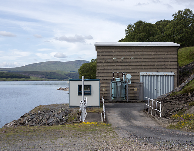
Loch an t-Searraich, located in Inverness-shire, is a picturesque freshwater loch nestled amidst the stunning Scottish Highlands. With an approximate area of 0.5 square kilometers, this natural water body offers a tranquil and serene environment for both locals and visitors to enjoy.

Surrounded by rolling hills and lush greenery, Loch an t-Searraich boasts crystal-clear waters that are perfect for various recreational activities. The loch is primarily used for fishing, attracting anglers from far and wide in search of its abundant fish population. Common species found in the loch include brown trout, rainbow trout, and pike, making it a haven for fishing enthusiasts.

The surrounding area of Loch an t-Searraich is also home to a diverse range of wildlife, including numerous bird species and small mammals. This makes it an ideal spot for birdwatchers and nature enthusiasts to observe and appreciate the local fauna.

The loch itself is relatively shallow, with an average depth of around 3 meters. Its shoreline is lined with reeds and grasses, creating a freshwater marsh ecosystem that supports various plant and animal species. The marsh provides essential habitats for wetland plants, such as water lilies and reed beds, which contribute to the ecological balance of the area.

Visitors to Loch an t-Searraich can enjoy the peaceful surroundings by taking leisurely walks along its shores or simply sitting back and admiring the breathtaking views of the Scottish countryside. The tranquil atmosphere and natural beauty of Loch an t-Searraich make it a must-visit destination for those seeking a peaceful retreat amidst the picturesque landscapes of Inverness-shire.

If you have any feedback on the listing, please let us know in the comments section below.

Loch an t-Searraich Images

Images are sourced within 2km of 56.828042/-4.3421224 or Grid Reference NN5773. Thanks to Geograph Open Source API. All images are credited.

Summit cairn on Beinn Udlamain
Slopes of Beinn Udlamain
Ruined walls or pile of stones In the middle of the moorland I came across this pile of stones that appeared to be rectangular in shape that could suggest a ruined sheiling or it may just be a pile of stones
Ruined walls or pile of stones
In the middle of the moorland I came across this pile of stones that appeared to be rectangular in shape that could suggest a ruined sheiling or it may just be a pile of stones
A Snow Bridge A patch of snow on the upper reaches of Allt Coire Dhomhain, hold right onto wet grass or make new footprints in the snow.
A Snow Bridge
A patch of snow on the upper reaches of Allt Coire Dhomhain, hold right onto wet grass or make new footprints in the snow.
Rock sculpture This little pile of rocks grabbed my attention, it reminded me of the Inukshuk I saw in the National Museum of Scotland, albeit a bit smaller.
Rock sculpture
This little pile of rocks grabbed my attention, it reminded me of the Inukshuk I saw in the National Museum of Scotland, albeit a bit smaller.
Beinn Udlamain summit cairn  Munro #61 A fantastic summit cairn, shelters and flat rocks to sit on on all sides, so at least you can get some shelter from just about any direction of wind.  The fence post sculpture I have seen in other photographs is now all piled up on the cairn.
Beinn Udlamain summit cairn Munro #61
A fantastic summit cairn, shelters and flat rocks to sit on on all sides, so at least you can get some shelter from just about any direction of wind. The fence post sculpture I have seen in other photographs is now all piled up on the cairn.
County boundary fence County boundary fence, Rowan and Birch trees on the East bank of Loch Ericht
County boundary fence
County boundary fence, Rowan and Birch trees on the East bank of Loch Ericht
Carn 'Ic Loumhaidh A view to the north from Carn 'Ic Loumhaidh towards Beinn Udlamain.
Carn 'Ic Loumhaidh
A view to the north from Carn 'Ic Loumhaidh towards Beinn Udlamain.
Coire Bhacaidh Steep ground in Coire Bhacaidh, viewed over the course of the Allt Udlamain, with Loch Ericht visible in the distance.
Coire Bhacaidh
Steep ground in Coire Bhacaidh, viewed over the course of the Allt Udlamain, with Loch Ericht visible in the distance.
North-western slopes of An Sgùlan The steep north-western slopes of An Sgùlan, with Beinn Udlamain visible in the distance.
North-western slopes of An Sgùlan
The steep north-western slopes of An Sgùlan, with Beinn Udlamain visible in the distance.
View towards Loch Ericht Steep ground on the north western slopes of An Sgùlan falling towards Loch Ericht.
View towards Loch Ericht
Steep ground on the north western slopes of An Sgùlan falling towards Loch Ericht.
Power station near Corrievarkie Lodge The hydroelectric power station on the shore of Loch Ericht, approximately one kilometre north east of Corrievarkie Lodge.
Power station near Corrievarkie Lodge
The hydroelectric power station on the shore of Loch Ericht, approximately one kilometre north east of Corrievarkie Lodge.
Coire Bhùirich The upper region of Coire Bhùirich, with the steep south-facing slopes of An Sgulan visible in the background.
Coire Bhùirich
The upper region of Coire Bhùirich, with the steep south-facing slopes of An Sgulan visible in the background.
Coire Dhomhain The boulder strewn western flank of Sgairneach Mhòr in the upper region of Coire Dhomhain.
Coire Dhomhain
The boulder strewn western flank of Sgairneach Mhòr in the upper region of Coire Dhomhain.
Summit area, Beinn Udlamain The flat summit plateau of Beinn Udlamain, the mountain of gloom (from the Gaelic Ùdlaidh, gloomy), viewed on a July evening.
Summit area, Beinn Udlamain
The flat summit plateau of Beinn Udlamain, the mountain of gloom (from the Gaelic Ùdlaidh, gloomy), viewed on a July evening.
Boundary on Carn 'lc Loumhaidh
Beinn Udlamain Ben Lawers to the left. The bold fence line is a rickety row of rusty posts in other seasons.
Beinn Udlamain
Ben Lawers to the left. The bold fence line is a rickety row of rusty posts in other seasons.
The plateau south of Beinn Udlamain Schiehallion can be seen on the skyline (right).
The plateau south of Beinn Udlamain
Schiehallion can be seen on the skyline (right).
Show me another place!

Loch an t-Searraich is located at Grid Ref: NN5773 (Lat: 56.828042, Lng: -4.3421224)

Unitary Authority: Highland

Police Authority: Highlands and Islands

What 3 Words

///plums.sprayer.spilling. Near Newtonmore, Highland

Related Wikis

Beinn Udlamain

Beinn Udlamain is a Scottish mountain which stands just to the west of the summit of the Pass of Drumochter and east of Loch Ericht, some 30 km west-northwest...

Loch Ericht

Loch Ericht (Scottish Gaelic: Loch Eireachd) is a freshwater loch on the border between the former Perthshire, now Perth and Kinross and the former Inverness...

Sgairneach Mhòr

Sgairneach Mhòr is a Scottish mountain which lies in a group of seven Munros near the summit of the Pass of Drumochter and are known as the Drumochter...

A' Mharconaich

A' Mharconaich (Scottish Gaelic: A' Mharcanaich) is a mountain near Dalwhinnie in the Scottish Highlands. It is a Munro with a height of 975 metres (3...

Have you been to Loch an t-Searraich?

Leave your review of Loch an t-Searraich below (or comments, questions and feedback).