Barmeen Hill

Hill, Mountain in Wigtownshire

Scotland

Barmeen Hill

Road junction near High Mindork
Road junction near High Mindork Credit: Nigel Thompson

Barmeen Hill is a prominent hill located in the region of Wigtownshire, in southwest Scotland. It is part of the Southern Uplands, a range of hills and mountains that stretches across the southern part of the country. Barmeen Hill rises to an elevation of 316 meters (1,037 feet) above sea level, making it a notable feature in the local landscape.

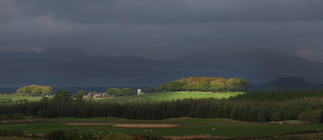
The hill is characterized by its gently sloping sides and rounded summit, which offers panoramic views of the surrounding countryside. Its slopes are covered in a patchwork of heather, grasses, and scattered trees, creating a picturesque scene throughout the year.

Barmeen Hill is a popular destination for outdoor enthusiasts and nature lovers. There are several hiking trails that lead to the summit, providing opportunities for visitors to explore the area's natural beauty. The hill’s accessible location and moderate elevation make it a suitable destination for people of all ages and fitness levels.

From the summit, on a clear day, visitors can enjoy breathtaking vistas of the surrounding countryside, including the rolling hills, farmland, and nearby Loch Ryan. The hill also offers a great vantage point to observe local wildlife, such as birds of prey, deer, and various species of small mammals.

Overall, Barmeen Hill is a picturesque and accessible natural landmark in Wigtownshire, offering visitors a chance to immerse themselves in the beauty of the Scottish countryside and enjoy stunning views of the surrounding area.

If you have any feedback on the listing, please let us know in the comments section below.

Barmeen Hill Images

Images are sourced within 2km of 54.890817/-4.6150013 or Grid Reference NX3258. Thanks to Geograph Open Source API. All images are credited.

Road junction near High Mindork
Wall and fence-lined minor road between High Mindork and Barnearnie Looking north-eastward.
Wall and fence-lined minor road between High Mindork and Barnearnie
Looking north-eastward.
West Crosherie Kirkcowan
West Crosherie
Kirkcowan
Barlennan Hill, low lying mist. Several hills around Kirkcowan have woods planted right on their tops. This was apparently done by a local landowner to commemorate the men who had fought in the Boer War, the hilltop plantings being reminiscent of the hilltop positions of his soldiers.
Barlennan Hill, low lying mist.
Several hills around Kirkcowan have woods planted right on their tops. This was apparently done by a local landowner to commemorate the men who had fought in the Boer War, the hilltop plantings being reminiscent of the hilltop positions of his soldiers.
Barlennan Plantation from Mid Hill Cairnsmore brooding in the background
Barlennan Plantation from Mid Hill
Cairnsmore brooding in the background
Floodwater, River Tarf Following 24 hours of heavy rain.
Floodwater, River Tarf
Following 24 hours of heavy rain.
Moorland near the Ballochrae Burn Looking to Barlennan Hill
Moorland near the Ballochrae Burn
Looking to Barlennan Hill
Barlennan Hill
Barlennan Hill
Barlennan Hill and Kirkcowan Church from near Mindork With the Galloway Hills beyond.
Barlennan Hill and Kirkcowan Church from near Mindork
With the Galloway Hills beyond.
Sheep near the Tarf Sheep foraging in the snow for grazing as an evening mist rises over the Tarf.
Sheep near the Tarf
Sheep foraging in the snow for grazing as an evening mist rises over the Tarf.
Barlennan Hill Viewed across a field still waterlogged from November's flooding, now frozen hard.
Barlennan Hill
Viewed across a field still waterlogged from November's flooding, now frozen hard.
Tarf Bridge Cottage The cottage right of picture sits at the side of the entrance track that leads to Kenmure Farm.
Tarf Bridge Cottage
The cottage right of picture sits at the side of the entrance track that leads to Kenmure Farm.
Tarf Water View of this river upstream which joins the River Bladnoch just east of Kirkcowan.
Tarf Water
View of this river upstream which joins the River Bladnoch just east of Kirkcowan.
Barnearnie View along this small country road towards Place Hill centre of picture.
Barnearnie
View along this small country road towards Place Hill centre of picture.
Kenmure This long access track runs down to Kenmure Farm.
Kenmure
This long access track runs down to Kenmure Farm.
Barchly This track leads to Barchly Hill and the dismantled railway that ran between Stranraer and Dumfries.
Barchly
This track leads to Barchly Hill and the dismantled railway that ran between Stranraer and Dumfries.
Tarf Bridge Cottage View along this track to the cottage which is well hidden left of picture behind trees and a stane wall.
Tarf Bridge Cottage
View along this track to the cottage which is well hidden left of picture behind trees and a stane wall.
Forest Break in Mindork Moss View along this break one of several through the moss.
Forest Break in Mindork Moss
View along this break one of several through the moss.
Show me another place!

Barmeen Hill is located at Grid Ref: NX3258 (Lat: 54.890817, Lng: -4.6150013)

Unitary Authority: Dumfries and Galloway

Police Authority: Dumfries and Galloway

What 3 Words

///manicured.wealth.votes. Near Newton Stewart, Dumfries & Galloway

Related Wikis

Kirkcowan

Kirkcowan is an area about 15 miles in length, and from nearly two to nearly seven miles in breadth, comprising 30,580 acres, of which 7000 are arable...

Kirkcowan railway station

Kirkcowan railway station served the village of Kirkcowan, Dumfries and Galloway, Scotland from 1861 to 1965 on the Portpatrick and Wigtownshire Joint...

Castle Loch, Dumfries and Galloway

Castle Loch is a large, shallow, freshwater loch in Dumfries and Galloway, in the Southern Uplands of south-west Scotland. It lies to the west of Mochrum...

Castle Loch

Castle Loch is a shallow eutrophic loch covering an area of around 100 hectares in the town of Lochmaben in Dumfries and Galloway, Scotland. It lies to...

Nearby Amenities

Located within 500m of 54.890817,-4.6150013
Turning Circle
Lat/Long: 54.888066/-4.6178409
The data included in this document is from www.openstreetmap.org. The data is made available under ODbL.

Have you been to Barmeen Hill?

Leave your review of Barmeen Hill below (or comments, questions and feedback).