Big Challoch Hill

Hill, Mountain in Wigtownshire

Scotland

Big Challoch Hill

Craigdow A long abandoned farm lying on the moor southwest of Clugston Loch. It was noted to be in ruins on the 1850 6" OS map.
Craigdow Credit: David Baird

Big Challoch Hill is a prominent geographical feature located in Wigtownshire, Scotland. Standing at an elevation of 316 meters (1,037 feet), it is classified as a hill rather than a mountain. Big Challoch Hill is situated near the village of Glenluce, approximately 10 kilometers (6 miles) southeast of Stranraer.

The hill is characterized by its steep slopes and distinctive conical shape, making it easily recognizable from the surrounding landscape. It is primarily composed of sedimentary rock formations, including sandstone and limestone, which have been shaped by natural erosion processes over millions of years.

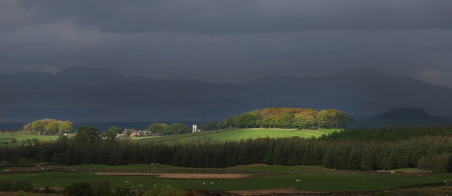
The summit of Big Challoch Hill offers panoramic views of the surrounding countryside, including glimpses of the Irish Sea to the west. The hill is covered in a mixture of heather, grasses, and scattered shrubs, providing habitat for a variety of wildlife, such as red grouse, rabbits, and various bird species.

Big Challoch Hill holds historical significance, as it is home to the remains of an ancient hillfort. This Iron Age settlement is believed to have been occupied from around 500 BC to 500 AD and is now protected as a Scheduled Ancient Monument.

The hill is a popular destination for outdoor enthusiasts, offering opportunities for hiking and nature exploration. Several walking trails lead to the summit, providing visitors with a chance to experience the beauty and tranquility of the surrounding Scottish countryside.

If you have any feedback on the listing, please let us know in the comments section below.

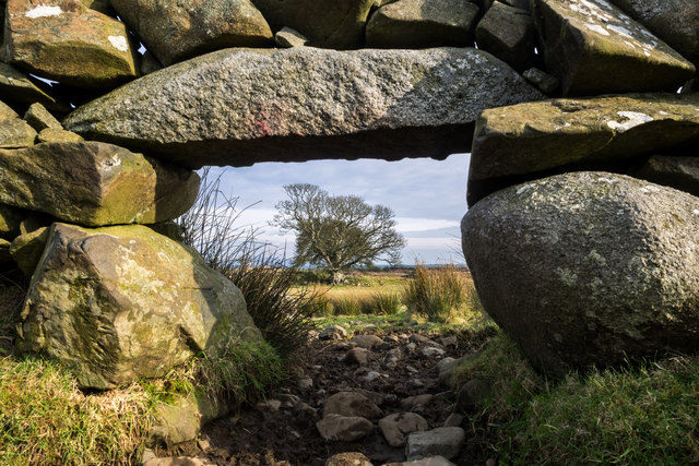
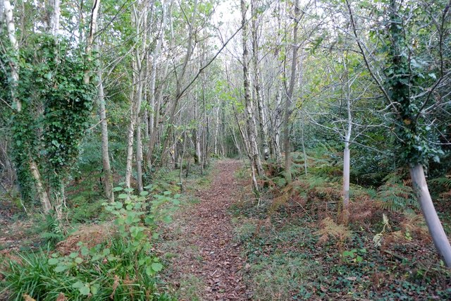
Big Challoch Hill Images

Images are sourced within 2km of 54.890424/-4.6073497 or Grid Reference NX3258. Thanks to Geograph Open Source API. All images are credited.

Craigdow A long abandoned farm lying on the moor southwest of Clugston Loch. It was noted to be in ruins on the 1850 6" OS map.
Craigdow
A long abandoned farm lying on the moor southwest of Clugston Loch. It was noted to be in ruins on the 1850 6" OS map.
Through the lunky hole A lunky hole is built in a drystone dyke to allow sheep to pass through it while holding back cattle. It can easily be blocked up with a small gate, board or stones. This one is in the dyke enclosing the old ruined farm of Craigdow.
Through the lunky hole
A lunky hole is built in a drystone dyke to allow sheep to pass through it while holding back cattle. It can easily be blocked up with a small gate, board or stones. This one is in the dyke enclosing the old ruined farm of Craigdow.
The Craigdow Burn The Craigdow Burn runs down from Craigdow Moor into the southern end of Clugston Loch.
The Craigdow Burn
The Craigdow Burn runs down from Craigdow Moor into the southern end of Clugston Loch.
Honeysuckle
Honeysuckle
Floodwater, River Tarf Following 24 hours of heavy rain.
Floodwater, River Tarf
Following 24 hours of heavy rain.
Elderflowers and chimney stack The chimney is all that remains of Armstrongs woollen mill, one of two neighbouring mills which were at one time the major employers in the area.
Elderflowers and chimney stack
The chimney is all that remains of Armstrongs woollen mill, one of two neighbouring mills which were at one time the major employers in the area.
Sheep near the Tarf Sheep foraging in the snow for grazing as an evening mist rises over the Tarf.
Sheep near the Tarf
Sheep foraging in the snow for grazing as an evening mist rises over the Tarf.
Track at West Crosherie Kirkcowan
Track at West Crosherie
Kirkcowan
Through the Woods Adjoining the River Tarff
Through the Woods
Adjoining the River Tarff
West Crosherie Kirkcowan
West Crosherie
Kirkcowan
Red Squirrel We currently have a healthy population of red squirrels in Galloway - in fact there seem to be more now than I can ever remember from years gone by. However the greys are beginning to encroach. Occasional individuals are turning up west of the River Cree, and their arrival often seems to be followed by the disappearance of the reds.
Red Squirrel
We currently have a healthy population of red squirrels in Galloway - in fact there seem to be more now than I can ever remember from years gone by. However the greys are beginning to encroach. Occasional individuals are turning up west of the River Cree, and their arrival often seems to be followed by the disappearance of the reds.
Greater spotted woodpecker
Red Squirrel We currently have a healthy population of red squirrels in Galloway - in fact there seem to be more now than I can ever remember from years gone by. However the greys are beginning to encroach. Occasional individuals are turning up west of the River Cree, and their arrival often seems to be followed by the disappearance of the reds.
Red Squirrel
We currently have a healthy population of red squirrels in Galloway - in fact there seem to be more now than I can ever remember from years gone by. However the greys are beginning to encroach. Occasional individuals are turning up west of the River Cree, and their arrival often seems to be followed by the disappearance of the reds.
Nuthatch Previously very scarce in Scotland, the nuthatch is gradually extending its range northwards - this is the first time I have seen them this far west in Dumfries and Galloway. Over the summer months I was lucky enough to be able to watch and photograph a pair of nuthatches and their offspring within this square.
Nuthatch
Previously very scarce in Scotland, the nuthatch is gradually extending its range northwards - this is the first time I have seen them this far west in Dumfries and Galloway. Over the summer months I was lucky enough to be able to watch and photograph a pair of nuthatches and their offspring within this square.
East Crosherie Entrance gate and track which leads to East Crosherie Farm.
East Crosherie
Entrance gate and track which leads to East Crosherie Farm.
Farm track This track runs from East Crosherie along the side of Long Range Plantation.
Farm track
This track runs from East Crosherie along the side of Long Range Plantation.
Track View along this track which runs down to Kirkcowan in this direction, left of picture on the horizon is West Crosherie Farm.
Track
View along this track which runs down to Kirkcowan in this direction, left of picture on the horizon is West Crosherie Farm.
East Crosherie View across land near the farm with West Crosherie Farm to the right and Barlennan Hill left of picture on the horizon.
East Crosherie
View across land near the farm with West Crosherie Farm to the right and Barlennan Hill left of picture on the horizon.
Show me another place!

Big Challoch Hill is located at Grid Ref: NX3258 (Lat: 54.890424, Lng: -4.6073497)

Unitary Authority: Dumfries and Galloway

Police Authority: Dumfries and Galloway

What 3 Words

///owner.prospered.husbands. Near Newton Stewart, Dumfries & Galloway

Related Wikis

Kirkcowan

Kirkcowan is an area about 15 miles in length, and from nearly two to nearly seven miles in breadth, comprising 30,580 acres, of which 7000 are arable...

Kirkcowan railway station

Kirkcowan railway station served the village of Kirkcowan, Dumfries and Galloway, Scotland from 1861 to 1965 on the Portpatrick and Wigtownshire Joint...

Torhouse

The Standing Stones of Torhouse (also Torhousekie) are a stone circle of nineteen granite boulders on the land of Torhouse, three miles west of Wigtown...

Mochrum Loch

Mochrum Loch is a large, irregular shaped, shallow, freshwater loch in Dumfries and Galloway, in the Southern Uplands of south-west Scotland. It lies approximately...

Have you been to Big Challoch Hill?

Leave your review of Big Challoch Hill below (or comments, questions and feedback).