Auchie Hill

Hill, Mountain in Kirkcudbrightshire

Scotland

Auchie Hill

Tormentil This little flower could be mistaken for a buttercup but its 4-petalled flower defines it as Tormentil (Potentilla erecta).  One of many yellow spring flowers commonly found along our footpaths and tracks.
Tormentil Credit: Mary and Angus Hogg

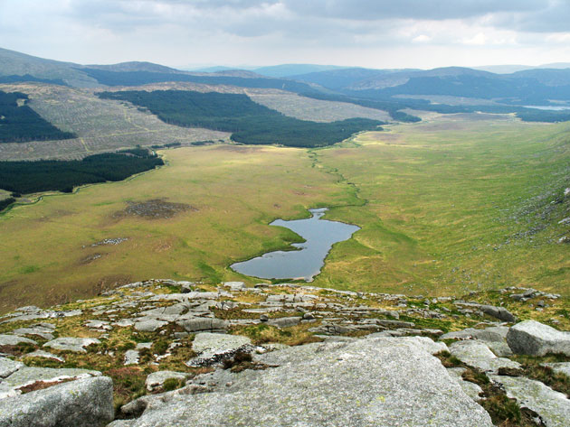
Auchie Hill is a prominent hill located in Kirkcudbrightshire, a historic county in southwest Scotland. It forms part of the scenic landscape near the village of Auchengray. Rising to an elevation of approximately 1,004 feet (306 meters), Auchie Hill offers stunning panoramic views of the surrounding countryside.

The hill is known for its distinctive shape, characterized by a gentle slope on one side and a steeper escarpment on the other. It is largely covered in grass and heather, with patches of woodland dotting its lower slopes. The hill's diverse vegetation provides a habitat for various plant and animal species, contributing to the area's biodiversity.

Auchie Hill serves as a popular destination for outdoor enthusiasts, offering opportunities for hiking and nature appreciation. A network of paths and trails crisscrosses the hill, providing access to its summit and allowing visitors to explore its diverse terrain. The hill's summit presents a fantastic vantage point, allowing visitors to admire the rolling hills, valleys, and waterways that stretch out below.

Aside from its natural beauty, Auchie Hill also holds archaeological significance. The area has been inhabited for thousands of years, and remnants of ancient settlements and burial mounds can be found on its slopes. These archaeological sites offer a glimpse into the region's rich history and provide valuable insight into the lives of past civilizations.

Overall, Auchie Hill in Kirkcudbrightshire is a captivating natural landmark that combines stunning vistas, biodiversity, and historic significance, making it a must-visit destination for nature lovers and history enthusiasts alike.

If you have any feedback on the listing, please let us know in the comments section below.
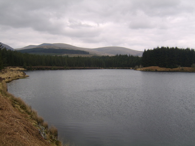
Auchie Hill Images

Images are sourced within 2km of 55.074772/-4.6272452 or Grid Reference NX3278. Thanks to Geograph Open Source API. All images are credited.

Tormentil This little flower could be mistaken for a buttercup but its 4-petalled flower defines it as Tormentil (Potentilla erecta).  One of many yellow spring flowers commonly found along our footpaths and tracks.
Tormentil
This little flower could be mistaken for a buttercup but its 4-petalled flower defines it as Tormentil (Potentilla erecta). One of many yellow spring flowers commonly found along our footpaths and tracks.
Coltsfoot flowers The bright yellow coltsfoot (Tussilago farfara) can be mistaken for a dandelion. These were growing on the forest track but the dry spring weather had kept them very small. One of many yellow spring flowers commonly found along our footpaths and tracks.
Coltsfoot flowers
The bright yellow coltsfoot (Tussilago farfara) can be mistaken for a dandelion. These were growing on the forest track but the dry spring weather had kept them very small. One of many yellow spring flowers commonly found along our footpaths and tracks.
Towards Dalnaw The minor road skirts the forest and leads to two remote farms.
Towards Dalnaw
The minor road skirts the forest and leads to two remote farms.
A forest track near Barjarg The road on the left gives access to Barjarg and Dalnaw while the track on the right continues into the forest.
A forest track near Barjarg
The road on the left gives access to Barjarg and Dalnaw while the track on the right continues into the forest.
Forest road The road gives access to a large area on Barjarg Hill, managed by Tilhill Forestry.
Forest road
The road gives access to a large area on Barjarg Hill, managed by Tilhill Forestry.
Swirls of cirrus The high-level wind had produced some spectacular swirls of goat’s hair cloud above the forest near Barwinnock.
Swirls of cirrus
The high-level wind had produced some spectacular swirls of goat’s hair cloud above the forest near Barwinnock.
Upper Reaches of River Cree
Auchie Island, River Cree Kayaking around Auchie Island on River Cree
Auchie Island, River Cree
Kayaking around Auchie Island on River Cree
Wall and fence near Cairnderry
Forest Track Near Bargrennan
A714 Near Bargrennan
Sheepfold Near Bargrennan
Cairnderry chambered cairn These are the stones visible on the surface of this chambered cairn. Details are available on <span class="nowrap"><a title="http://www.uclan.ac.uk/facs/science/archaeology/chamberedtombs.htm" rel="nofollow ugc noopener" href="http://www.uclan.ac.uk/facs/science/archaeology/chamberedtombs.htm">Link</a><img style="margin-left:2px;" alt="External link" title="External link - shift click to open in new window" src="https://s1.geograph.org.uk/img/external.png" width="10" height="10"/></span>
Cairnderry chambered cairn
These are the stones visible on the surface of this chambered cairn. Details are available on LinkExternal link
Forest Firebreak A break in the forest near Dornal Hill. Newly constructed tracks allow access to this part of the forest.
Forest Firebreak
A break in the forest near Dornal Hill. Newly constructed tracks allow access to this part of the forest.
Forest Track A newly constructed forest track near Dornal Hill
Forest Track
A newly constructed forest track near Dornal Hill
Log Piles Near Dornal Hill
Track Near Barwinnock
Track Near Barwinnock A little used track leading to Barjarg Hill
Track Near Barwinnock
A little used track leading to Barjarg Hill
Show me another place!

Auchie Hill is located at Grid Ref: NX3278 (Lat: 55.074772, Lng: -4.6272452)

Unitary Authority: Dumfries and Galloway

Police Authority: Dumfries and Galloway

What 3 Words

///showering.gifted.claim. Near Newton Stewart, Dumfries & Galloway

Related Wikis

Cairnderry chambered cairn

Cairnderry chambered cairn is a chambered cairn in Dumfries and Galloway. It is a Bargrennan cairn, a type of Neolithic or early Bronze Age monument only...

Bargrennan

Bargrennan (Scottish Gaelic: Bar Grianain, meaning height of the summer house or sunny spot) is a village in Dumfries and Galloway, in the south west of...

Loch Dornal

Loch Dornal is an irregular shaped, shallow, freshwater loch in south Ayrshire, in the Southern Uplands of Scotland. It lies approximately eight miles...

Glentrool

Glentrool is a collection of mountain biking routes through the heart of Galloway in southwest Scotland. The mountain bike routes are part of the 7Stanes...

Glen Trool

Glen Trool (Scottish Gaelic: Gleann an t-Sruthail) is a glen in the Southern Uplands, Galloway, Scotland. It contains Loch Trool which is fed by several...

Silver Flowe-Merrick Kells

Situated in south-west Scotland, the Silver Flowe-Merrick Kells biosphere reserve is composed of two separate sites. Silver Flowe is a unique bog formation...

Loch Trool

Loch Trool is a narrow, freshwater loch in Galloway, in the Southern Uplands in south-west Scotland. It lies in an elevated position in Glen Trool in the...

Kirriereoch Loch

Kirriereoch Loch is a small, shallow, square shaped, freshwater loch in Dumfries and Galloway, in the Southern Uplands of south-west Scotland. It lies...

Nearby Amenities

Located within 500m of 55.074772,-4.6272452
Power: pole
Lat/Long: 55.0718304/-4.6322058
Power: pole
Lat/Long: 55.07254/-4.6321706
Power: pole
Lat/Long: 55.0732159/-4.6321541
Power: pole
Lat/Long: 55.0738016/-4.6321423
Power: pole
Lat/Long: 55.0744263/-4.6321094
Power: pole
Lat/Long: 55.0751857/-4.6316109
Power: pole
Lat/Long: 55.0757108/-4.6312722
Power: pole
Lat/Long: 55.076256/-4.6309195
Power: pole
Lat/Long: 55.0767515/-4.6305738
Power: pole
Lat/Long: 55.0772859/-4.6302304
Power: pole
Lat/Long: 55.0777733/-4.6299247
Power: pole
Lat/Long: 55.078441/-4.6295202
Power: pole
Lat/Long: 55.0789984/-4.6291486
The data included in this document is from www.openstreetmap.org. The data is made available under ODbL.

Have you been to Auchie Hill?

Leave your review of Auchie Hill below (or comments, questions and feedback).