Mullach na Briobaig

Hill, Mountain in Inverness-shire

Scotland

Mullach na Briobaig

Winter sun on an old Scots Pine Glen Mallie at dawn. The distant fog lies on Loch Arkaig.
Winter sun on an old Scots Pine Credit: Alan Reid

Mullach na Briobaig is a prominent hill located in the Inverness-shire region of Scotland. Sitting at an elevation of 845 meters (2,772 feet), it is considered one of the notable peaks in the area.

Located in the southwestern region of Inverness-shire, Mullach na Briobaig is part of the wider Glen Shiel range of mountains. It is situated near the village of Invermoriston and offers breathtaking panoramic views of the surrounding landscape.

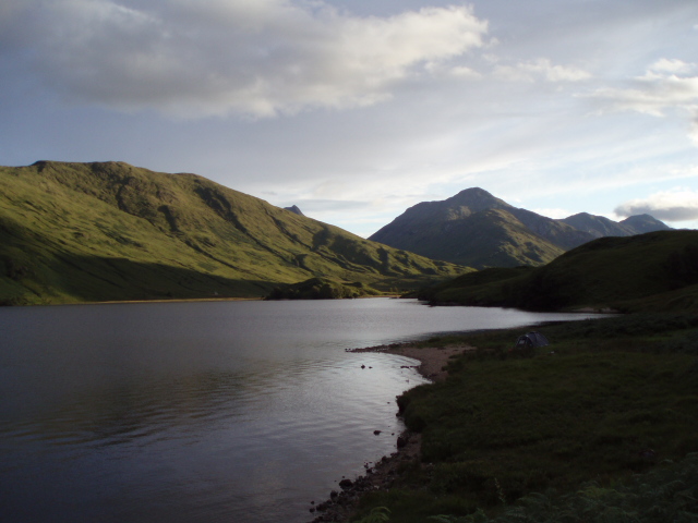
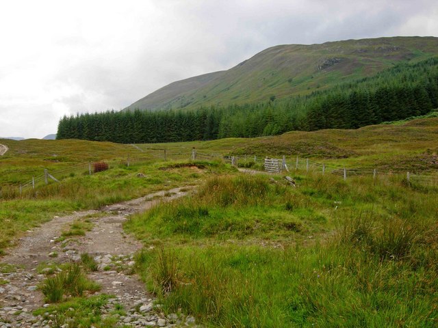
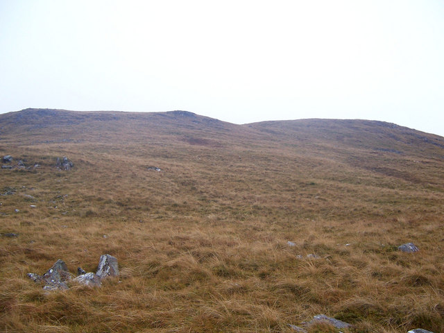
The hill is characterized by its rugged and rocky terrain, making it a popular destination for hikers and mountaineers. Its steep slopes and challenging ascent provide an exhilarating experience for outdoor enthusiasts. The summit of Mullach na Briobaig offers stunning views of Loch Ness and the surrounding glens, rewarding climbers with a sense of accomplishment.

The hill is also home to a diverse range of flora and fauna. Its lower slopes are covered with heather and grasses, while the higher regions are adorned with patches of rugged vegetation and mosses. The area supports a variety of bird species, including golden eagles, peregrine falcons, and ptarmigans.

Due to its location in the Scottish Highlands, Mullach na Briobaig is subject to unpredictable weather conditions. It is recommended that visitors come prepared with appropriate clothing and equipment, as the weather can change rapidly.

Overall, Mullach na Briobaig is a captivating natural landmark in Inverness-shire, offering outdoor enthusiasts and nature lovers a challenging and rewarding experience amidst stunning Scottish scenery.

If you have any feedback on the listing, please let us know in the comments section below.

Mullach na Briobaig Images

Images are sourced within 2km of 56.953156/-5.1204078 or Grid Reference NN1088. Thanks to Geograph Open Source API. All images are credited.

Winter sun on an old Scots Pine Glen Mallie at dawn. The distant fog lies on Loch Arkaig.
Winter sun on an old Scots Pine
Glen Mallie at dawn. The distant fog lies on Loch Arkaig.
Birches in Glen Mallie
Gravel track in Glen Mallie
Glen Mallie The estate track penetrates deeply into otherwise remote country, from a starting point at the outlet of Loch Arkaig. The slopes on the north side of the glen are barren with just a few scattered pines and an odd birch. The south side, steeper and cooler on north-facing slopes, still supports a considerable scattering of Scots Pines, though hardly what you might have expected from the "forest" shown on the Ordnance Survey maps. Many of the standing trees are dead, and there is little if any regeneration as tree seedlings make tasty morsels for hungry deer, of which there are far too many for forest to return.
Glen Mallie
The estate track penetrates deeply into otherwise remote country, from a starting point at the outlet of Loch Arkaig. The slopes on the north side of the glen are barren with just a few scattered pines and an odd birch. The south side, steeper and cooler on north-facing slopes, still supports a considerable scattering of Scots Pines, though hardly what you might have expected from the "forest" shown on the Ordnance Survey maps. Many of the standing trees are dead, and there is little if any regeneration as tree seedlings make tasty morsels for hungry deer, of which there are far too many for forest to return.
The road up Glen Mallie Sunrise in late January. No snow to be seen.
The road up Glen Mallie
Sunrise in late January. No snow to be seen.
Gravel track in Glen Mallie
Bracken and Scots pine in Glen Mallie
Gravel track in Glen Mallie
Looking East along Arkaig
Looking West along Loch Arkaig shoreline
Native woodlands on the banks of Loch Arkaig
Remnant forest, Glen Mallie A small patch of remnant pine and birch on the south-facing slope of Sròn nan Leac  above Glen Mallie.
Remnant forest, Glen Mallie
A small patch of remnant pine and birch on the south-facing slope of Sròn nan Leac above Glen Mallie.
A bridge and a few trees Pretty much the last of the pine and birch forest in Glen Mallie, it's all open moor above here. The bridge carries the newish track over a small burn draining from Sròn nan Leac.
A bridge and a few trees
Pretty much the last of the pine and birch forest in Glen Mallie, it's all open moor above here. The bridge carries the newish track over a small burn draining from Sròn nan Leac.
Heading downhill for a change The newish track up the glen mostly goes uphill, but this section makes a welcome relief on the unusual approach to Meall a’ Phuibill, the Corbett at the head of the glen.
Heading downhill for a change
The newish track up the glen mostly goes uphill, but this section makes a welcome relief on the unusual approach to Meall a’ Phuibill, the Corbett at the head of the glen.
Surviving woodland, Glen Mallie Pines and birches in a glen with some surviving old woodland.
Surviving woodland, Glen Mallie
Pines and birches in a glen with some surviving old woodland.
Bend of estate road in Glen Mallie The road heading out of the glen towards the foot of Loch Arkaig and the settlement at Achnacarry.
Bend of estate road in Glen Mallie
The road heading out of the glen towards the foot of Loch Arkaig and the settlement at Achnacarry.
Bruised line track over moorland The ATV track is over moorland to the east of Druim na Giubhsaich.
Beinn Bhàn is the mountain beyond, lying across Glen Mallie.
Bruised line track over moorland
The ATV track is over moorland to the east of Druim na Giubhsaich. Beinn Bhàn is the mountain beyond, lying across Glen Mallie.
Embedded rocks east of Druim na Giubhsaich The gradual descent of the section of ridge named as Druim na Giubhsaich eventually steepens to the east. The embedded rocks are on that steeper ground.
Loch Arkaig lies below with Sgurr Chòinnich being the obvious mountain at the image centre.
Embedded rocks east of Druim na Giubhsaich
The gradual descent of the section of ridge named as Druim na Giubhsaich eventually steepens to the east. The embedded rocks are on that steeper ground. Loch Arkaig lies below with Sgurr Chòinnich being the obvious mountain at the image centre.
Show me another place!

Mullach na Briobaig is located at Grid Ref: NN1088 (Lat: 56.953156, Lng: -5.1204078)

Unitary Authority: Highland

Police Authority: Highlands and Islands

What 3 Words

///field.subjects.uppermost. Near Gairlochy, Highland

Related Wikis

Loch Arkaig

Loch Arkaig (Scottish Gaelic: Loch Airceig) is a body of freshwater in Lochaber, Scotland, to the west of the Great Glen. It is approximately 12 miles...

Ardechive

Ardechive (Scottish Gaelic: Àird Eachbhaidh) is a small crofting hamlet, located on the shores of Loch Arkaig, close to Achnasaul and Spean Bridge, county...

Beinn Bhàn (Arkaig)

Beinn Bhàn is a Scottish mountain situated in the Lochaber region of the Highland Council Area. It stands 6 miles (10 km) north-west of Spean Bridge. The...

Battle of Drumlui

The Battle of Drumlui was a Scottish clan battle that took place in either 1330 or 1337, in the Scottish Highlands between the Clan Cameron and the Clan...

Achnasaul

Achnasaul (Scottish Gaelic: Achadh nan Sabhal) is a village, located on the shores of Loch Arkaig, close to Spean Bridge, Inverness-shire, Scotland, within...

Glen Loy

Glen Loy is a glen or valley in the Northwest Highlands of Scotland which opens onto the Great Glen at its eastern end. It is drained by the River Loy...

Druim Fada (Corpach)

Druim Fada (744 m) is a mountain in the Northwest Highlands of Scotland. It lies on the northern shore of Loch Eil in Lochaber, near the village of Corpach...

Stand-off at the Fords of Arkaig

The Stand-off at the Ford of Arkaig occurred in September 1665 at Achnacarry, about 10 miles (16 km) northeast of Fort William, Scotland. The Chattan Confederation...

Nearby Amenities

Located within 500m of 56.953156,-5.1204078
Mullach na Briobaig
Ele: 380
Natural: peak
Note: position estimated
Lat/Long: 56.9531661/-5.1223755
The data included in this document is from www.openstreetmap.org. The data is made available under ODbL.

Have you been to Mullach na Briobaig?

Leave your review of Mullach na Briobaig below (or comments, questions and feedback).