Carn Naun

Hill, Mountain in Cornwall

England

Carn Naun

Penwitch : Hor Point Looking back towards Hor Point and along the Cornish coastline.
Penwitch : Hor Point Credit: Lewis Clarke

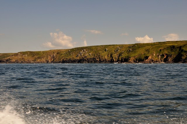
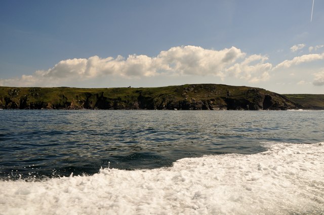
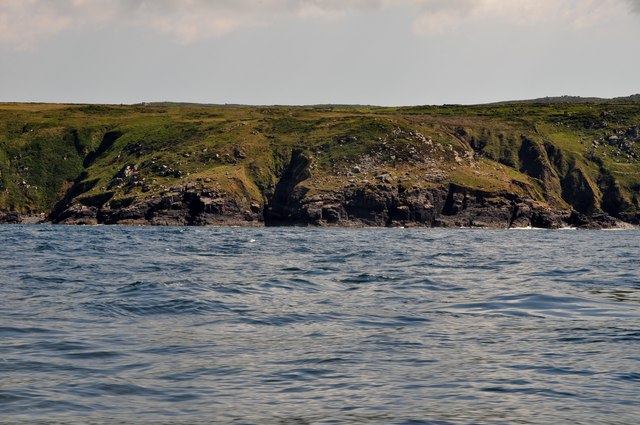
Carn Naun is a prominent hill located in Cornwall, England. It is situated in the southwestern part of the county, near the village of St Keverne. With an elevation of approximately 183 meters (600 feet), Carn Naun offers stunning panoramic views of the surrounding countryside and the nearby coastline.

The hill is characterized by its gentle slopes and lush greenery, making it a popular destination for hikers and nature enthusiasts. It is covered in a variety of vegetation, including grasses, heather, and gorse, which add to its natural beauty. The diversity of flora and fauna found on Carn Naun contributes to its ecological significance.

Carn Naun also holds historical importance, as evidenced by the presence of ancient barrows on its slopes. These burial mounds are remnants of the area's prehistoric past, providing an insight into the lives of early inhabitants.

Access to Carn Naun is relatively easy, as it is located near a number of footpaths and trails. Visitors can take advantage of these well-maintained routes to reach the summit and enjoy the breathtaking views. The hill's proximity to the village of St Keverne allows for easy access to amenities such as parking, accommodation, and dining options.

Overall, Carn Naun is a picturesque hill in Cornwall that offers a combination of natural beauty, historical significance, and recreational opportunities. Whether for a leisurely stroll or a challenging hike, it is a destination that appeals to both locals and tourists alike.

If you have any feedback on the listing, please let us know in the comments section below.

Carn Naun Images

Images are sourced within 2km of 50.213488/-5.5371194 or Grid Reference SW4740. Thanks to Geograph Open Source API. All images are credited.

Penwitch : Hor Point Looking back towards Hor Point and along the Cornish coastline.
Penwitch : Hor Point
Looking back towards Hor Point and along the Cornish coastline.
Penwith : Boat & Ocean A view from a boat as it heads along the Cornish Coastline
Penwith : Boat & Ocean
A view from a boat as it heads along the Cornish Coastline
Penwith : Cornish Coastline Looking along the Cornish Coastline from a boat heading towards Seal Island.
Penwith : Cornish Coastline
Looking along the Cornish Coastline from a boat heading towards Seal Island.
Penwith : The Carracks The Carracks are a group of rocks off of the Cornish coastline.
Penwith : The Carracks
The Carracks are a group of rocks off of the Cornish coastline.
Penwith : Bird on the Carracks A bird is out of harms way and in the sun here at the Carracks.
Penwith : Bird on the Carracks
A bird is out of harms way and in the sun here at the Carracks.
Penwith : Seal & Coastline A seal comes and greets us and poses for a photo with the coastline in the background.
Penwith : Seal & Coastline
A seal comes and greets us and poses for a photo with the coastline in the background.
Penwith : The Carracks The Carracks are also known as Seal Island because it's where the seals live.
Penwith : The Carracks
The Carracks are also known as Seal Island because it's where the seals live.
Penwith : The Carracks The Carracks and Little Carracks are a group of small rocky inshore islands off the Atlantic north coast of west Cornwall, United Kingdom. The name comes from "carrek", the Cornish language word for 'rock'.
Penwith : The Carracks
The Carracks and Little Carracks are a group of small rocky inshore islands off the Atlantic north coast of west Cornwall, United Kingdom. The name comes from "carrek", the Cornish language word for 'rock'.
Penwith : Seals at Seal Island The largest island in the group known as the Carracks is sometimes referred to as 'Seal Island' and is home to Atlantic Grey Seals, dogfish, anglerfish and sea anemones.
Penwith : Seals at Seal Island
The largest island in the group known as the Carracks is sometimes referred to as 'Seal Island' and is home to Atlantic Grey Seals, dogfish, anglerfish and sea anemones.
Penwith : Cornish Coastline Looking towards the coastline from a square marked as being out at sea.
Penwith : Cornish Coastline
Looking towards the coastline from a square marked as being out at sea.
Penwith : Carn Naun Point & Little Carracks Rocks out to sea and a headland along the rocky Cornish coastline.
Penwith : Carn Naun Point & Little Carracks
Rocks out to sea and a headland along the rocky Cornish coastline.
Penwith : Carn Naun Point Waves crashing against the headland along the rocky Cornish coastline.
Penwith : Carn Naun Point
Waves crashing against the headland along the rocky Cornish coastline.
Penwith : Cornish Coastline On the ocean about a kilometre off the Cornish coastline.
Penwith : Cornish Coastline
On the ocean about a kilometre off the Cornish coastline.
Penwith : Cornish Coastline From a boat out to sea looking across the coast of Cornwall.
Penwith : Cornish Coastline
From a boat out to sea looking across the coast of Cornwall.
Penwith : Cornish Coastline Looking back towards the Carracks and along the coastline.
Penwith : Cornish Coastline
Looking back towards the Carracks and along the coastline.
Penwith : Cornish Coastline Looking towards the coastline of Cornwall on a boat heading from the Carracks to St Ives.
Penwith : Cornish Coastline
Looking towards the coastline of Cornwall on a boat heading from the Carracks to St Ives.
Penwith : Cornish Coastline From a boat out at sea looking towards the Cornish coastline.
Penwith : Cornish Coastline
From a boat out at sea looking towards the Cornish coastline.
Penwith : Cornish Coastline Looking towards the coastline of Cornwall.
Penwith : Cornish Coastline
Looking towards the coastline of Cornwall.
Show me another place!

Carn Naun is located at Grid Ref: SW4740 (Lat: 50.213488, Lng: -5.5371194)

Unitary Authority: Cornwall

Police Authority: Devon and Cornwall

What 3 Words

///origin.convert.motivates. Near St Ives, Cornwall

Related Wikis

The Carracks

The Carracks (Cornish: Kerrek, meaning rocks) and Little Carracks (Cornish: Karrek an Ydhyn, meaning rock of the birds) are a group of small rocky inshore...

Hellesveor

Hellesveor (Cornish: Hellys Meur) is a hamlet near St Ives (where the 2011 census population was included) in west Cornwall, England. == References ==

Sperris Quoit

Sperris Quoit is a ruined megalithic burial chamber or dolmen, and one of a type of tomb unique to West Penwith, located on a moor around 365 metres northeast...

Towednack

Towednack (Cornish: Tewydnek) is a churchtown and civil parish in Cornwall, England, United Kingdom. The parish is bounded by those of Zennor in the west...

Nearby Amenities

Located within 500m of 50.213488,-5.5371194
Source: PGS
Lat/Long: 50.2138171/-5.5315621
Source: PGS
Lat/Long: 50.2115851/-5.5432741
Carn Naun
Description: OS trig pillar
Ele: 96.926
Man Made: survey_point
Note: Accurate location import for imagery offset calibration
Ref: S8139
Source: Ordnance Survey (OGL)
Survey Point: pillar
Lat/Long: 50.213479/-5.5371662
Barrier: kissing_gate
Source: GPS survey
Lat/Long: 50.2128739/-5.5346005
Old Church Ruins
Fixme: Its more likely these are old mine ruins
Name En: Old Church Ruins
Tourism: attraction
Lat/Long: 50.2105257/-5.5323015
Hiking: yes
Information: guidepost
Source: GPS survey
Tourism: information
Lat/Long: 50.2129218/-5.5344419
Entrance: yes
Lat/Long: 50.211565/-5.5329868
Entrance: yes
Lat/Long: 50.2116182/-5.5340624
Entrance: yes
Lat/Long: 50.2107908/-5.5325952
Entrance: yes
Lat/Long: 50.2123031/-5.5316001
Entrance: yes
Lat/Long: 50.2123503/-5.5315559
Entrance: yes
Lat/Long: 50.2123082/-5.5337808
Entrance: yes
Lat/Long: 50.2115152/-5.5330217
Entrance: yes
Lat/Long: 50.210899/-5.5332363
Entrance: yes
Lat/Long: 50.2107393/-5.533821
Entrance: yes
Lat/Long: 50.2104458/-5.5348322
Entrance: yes
Lat/Long: 50.2104475/-5.5382091
River Cove
Natural: bay
Lat/Long: 50.2123429/-5.5435285
Brea Cove
Natural: bay
Lat/Long: 50.2142447/-5.5306217
Bench
Backrest: no
Material: stone
Lat/Long: 50.2138614/-5.5354038
The data included in this document is from www.openstreetmap.org. The data is made available under ODbL.

Have you been to Carn Naun?

Leave your review of Carn Naun below (or comments, questions and feedback).