Treveal

Settlement in Cornwall

England

Treveal

Penwith : Boat & Ocean A view from a boat as it heads along the Cornish Coastline
Penwith : Boat & Ocean Credit: Lewis Clarke

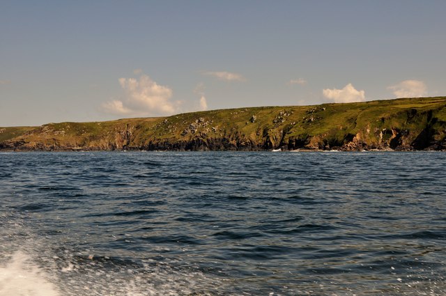
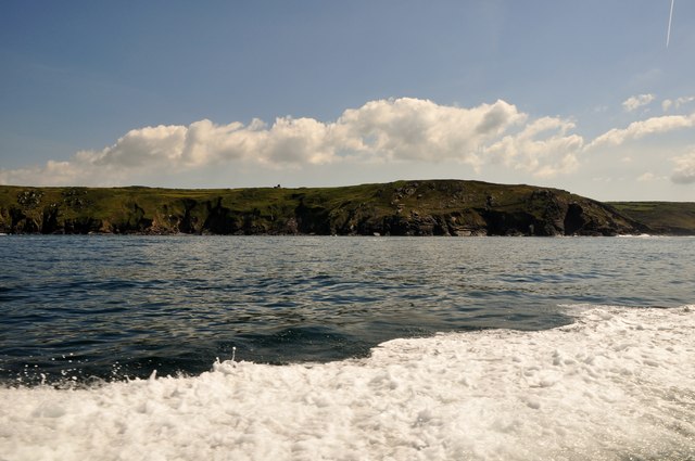
Treveal is a small coastal village located in the county of Cornwall, England. Situated on the north coast between the towns of St Ives and Hayle, Treveal is renowned for its picturesque setting and stunning natural beauty. The village is nestled within rolling green hills, offering sweeping views of the rugged coastline and the vast Atlantic Ocean.

Treveal is a popular destination for tourists seeking a tranquil and idyllic retreat. Its sandy beaches, such as Treveal Sands and Porth Treveal, attract visitors looking to relax, sunbathe, and enjoy water activities such as swimming and surfing. The clear blue waters also make it a great spot for snorkeling and diving.

The village itself is characterized by its charming and quaint atmosphere. Traditional Cornish stone cottages line the narrow streets, while a few local shops, cafes, and pubs provide essential services and a taste of local cuisine. The community is known for its warm hospitality and welcoming spirit, ensuring visitors feel at home.

Nature enthusiasts will find plenty to explore in the surrounding area. Treveal is located close to several nature reserves, including the nearby Hayle Estuary, which is a haven for birdwatchers. The South West Coast Path, which passes through Treveal, offers breathtaking hikes along the cliff tops and provides access to hidden coves and secluded beaches.

Overall, Treveal offers a serene and picturesque escape, combining natural beauty with a warm community atmosphere, making it an ideal destination for those seeking a peaceful and relaxing retreat in Cornwall.

If you have any feedback on the listing, please let us know in the comments section below.

Treveal Images

Images are sourced within 2km of 50.205808/-5.5470223 or Grid Reference SW4740. Thanks to Geograph Open Source API. All images are credited.

Penwith : Boat & Ocean A view from a boat as it heads along the Cornish Coastline
Penwith : Boat & Ocean
A view from a boat as it heads along the Cornish Coastline
Penwith : Cornish Coastline Looking along the Cornish Coastline from a boat heading towards Seal Island.
Penwith : Cornish Coastline
Looking along the Cornish Coastline from a boat heading towards Seal Island.
Penwith : The Carracks The Carracks are a group of rocks off of the Cornish coastline.
Penwith : The Carracks
The Carracks are a group of rocks off of the Cornish coastline.
Penwith : Bird on the Carracks A bird is out of harms way and in the sun here at the Carracks.
Penwith : Bird on the Carracks
A bird is out of harms way and in the sun here at the Carracks.
Penwith : Seal & Coastline A seal comes and greets us and poses for a photo with the coastline in the background.
Penwith : Seal & Coastline
A seal comes and greets us and poses for a photo with the coastline in the background.
Penwith : The Carracks The Carracks are also known as Seal Island because it's where the seals live.
Penwith : The Carracks
The Carracks are also known as Seal Island because it's where the seals live.
Penwith : The Carracks The Carracks and Little Carracks are a group of small rocky inshore islands off the Atlantic north coast of west Cornwall, United Kingdom. The name comes from "carrek", the Cornish language word for 'rock'.
Penwith : The Carracks
The Carracks and Little Carracks are a group of small rocky inshore islands off the Atlantic north coast of west Cornwall, United Kingdom. The name comes from "carrek", the Cornish language word for 'rock'.
Penwith : Seals at Seal Island The largest island in the group known as the Carracks is sometimes referred to as 'Seal Island' and is home to Atlantic Grey Seals, dogfish, anglerfish and sea anemones.
Penwith : Seals at Seal Island
The largest island in the group known as the Carracks is sometimes referred to as 'Seal Island' and is home to Atlantic Grey Seals, dogfish, anglerfish and sea anemones.
Penwith : Cornish Coastline Looking towards the coastline from a square marked as being out at sea.
Penwith : Cornish Coastline
Looking towards the coastline from a square marked as being out at sea.
Penwith : Carn Naun Point & Little Carracks Rocks out to sea and a headland along the rocky Cornish coastline.
Penwith : Carn Naun Point & Little Carracks
Rocks out to sea and a headland along the rocky Cornish coastline.
Penwith : Carn Naun Point Waves crashing against the headland along the rocky Cornish coastline.
Penwith : Carn Naun Point
Waves crashing against the headland along the rocky Cornish coastline.
Penwith : Cornish Coastline On the ocean about a kilometre off the Cornish coastline.
Penwith : Cornish Coastline
On the ocean about a kilometre off the Cornish coastline.
Penwith : Cornish Coastline From a boat out to sea looking across the coast of Cornwall.
Penwith : Cornish Coastline
From a boat out to sea looking across the coast of Cornwall.
Penwith : Cornish Coastline Looking back towards the Carracks and along the coastline.
Penwith : Cornish Coastline
Looking back towards the Carracks and along the coastline.
Penwith : Cornish Coastline Looking towards the coastline of Cornwall on a boat heading from the Carracks to St Ives.
Penwith : Cornish Coastline
Looking towards the coastline of Cornwall on a boat heading from the Carracks to St Ives.
The Carracks A main island and several additional rocks that protrude above the mean sea level a few hundred metres off the coast at Treveal Cliff.  This is the location that the seal watching boats from St Ives usually come to.  Indeed there was one boat there as we watched, and, with binoculars, we could see a few seals from here.
The Carracks
A main island and several additional rocks that protrude above the mean sea level a few hundred metres off the coast at Treveal Cliff. This is the location that the seal watching boats from St Ives usually come to. Indeed there was one boat there as we watched, and, with binoculars, we could see a few seals from here.
Cove River Is that its name?  The coastal path crosses this river, really a brook, on a stone footbridge here.  The brook drops another 50 metres to the coast at a place called River Cove.  How much are the names tautologous?
Cove River
Is that its name? The coastal path crosses this river, really a brook, on a stone footbridge here. The brook drops another 50 metres to the coast at a place called River Cove. How much are the names tautologous?
Show me another place!

Treveal is located at Grid Ref: SW4740 (Lat: 50.205808, Lng: -5.5470223)

Unitary Authority: Cornwall

Police Authority: Devon and Cornwall

What 3 Words

///surpasses.imperious.engrossed. Near St Ives, Cornwall

Related Wikis

The Carracks

The Carracks (Cornish: Kerrek, meaning rocks) and Little Carracks (Cornish: Karrek an Ydhyn, meaning rock of the birds) are a group of small rocky inshore...

Sperris Quoit

Sperris Quoit is a ruined megalithic burial chamber or dolmen, and one of a type of tomb unique to West Penwith, located on a moor around 365 metres northeast...
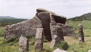
Zennor Quoit

Zennor Quoit is a ruined megalithic burial chamber or dolmen, located on a moor about a mile (1.6 km) east of the village of Zennor, Cornwall, England...
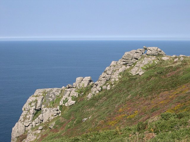
Zennor Head

Zennor Head ; (Cornish: Penn Senar) is a 750-metre (2,460 ft) long promontory on the Cornish coast of England, between Pendour Cove and Porthzennor Cove...

Nearby Amenities

Located within 500m of 50.205808,-5.5470223
Barrier: cattle_grid
Lat/Long: 50.207029/-5.5405233
Hiking: yes
Information: guidepost
Source: GPS survey
Tourism: information
Lat/Long: 50.2070438/-5.5406114
Entrance: yes
Lat/Long: 50.2019259/-5.5474547
Entrance: yes
Lat/Long: 50.2028166/-5.5455933
Entrance: yes
Lat/Long: 50.2022418/-5.5491257
Entrance: yes
Lat/Long: 50.202089/-5.547798
Entrance: yes
Lat/Long: 50.2026487/-5.542742
Power: pole
Lat/Long: 50.201871/-5.5440724
Power: pole
Lat/Long: 50.2016048/-5.5451721
The data included in this document is from www.openstreetmap.org. The data is made available under ODbL.

Have you been to Treveal?

Leave your review of Treveal below (or comments, questions and feedback).