Cnoc an Fheidh

Hill, Mountain in Ross-shire

Scotland

Cnoc an Fheidh

View towards Loch Chàrlabhaigh
View towards Loch Chàrlabhaigh Credit: David Dixon

Cnoc an Fheidh, also known as Cnoc Fidh, is a prominent hill located in Ross-shire, Scotland. It is situated in the Northwest Highlands, near the village of Evanton. Cnoc an Fheidh stands at an elevation of 374 meters (1,227 feet) above sea level, offering breathtaking panoramic views of the surrounding area.

The hill is characterized by its distinctive conical shape and is covered in heather and grass, contributing to the picturesque landscape. It is a popular destination for hikers and nature enthusiasts due to its accessibility and stunning vistas.

A well-defined path leads to the summit, making it relatively easy for visitors to reach the top. Along the way, walkers can enjoy the sight of diverse wildlife, including deer, birds, and smaller mammals such as rabbits and foxes.

Once at the summit, visitors are rewarded with unparalleled views of the Cromarty Firth, the Black Isle, and the surrounding mountain ranges. On clear days, one can even catch a glimpse of the Moray Firth and the distant peaks of the Cairngorms National Park.

Cnoc an Fheidh offers a peaceful and serene atmosphere, providing the perfect opportunity to relax and immerse oneself in the tranquility of the Scottish Highlands. Whether it is for a leisurely stroll or a challenging hike, this hill is a must-visit for anyone seeking to experience the natural beauty and serenity of Ross-shire.

If you have any feedback on the listing, please let us know in the comments section below.

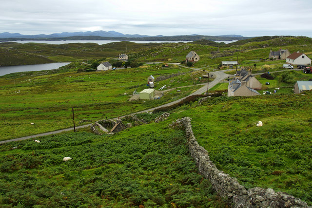
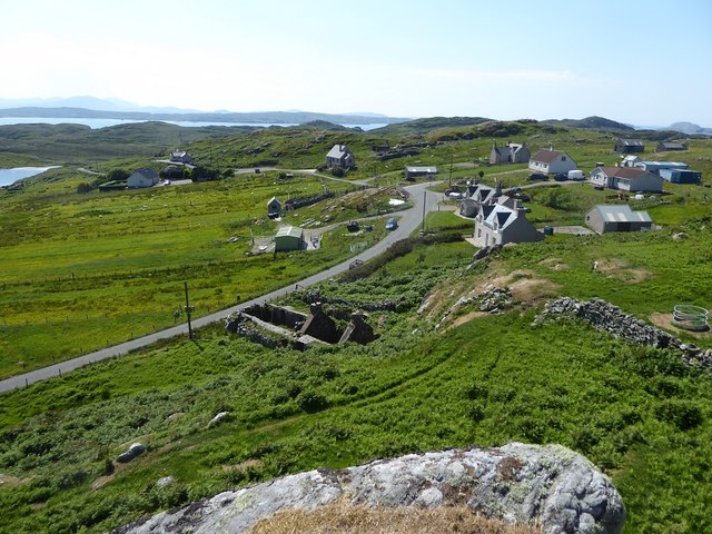
Cnoc an Fheidh Images

Images are sourced within 2km of 58.285765/-6.8077583 or Grid Reference NB1843. Thanks to Geograph Open Source API. All images are credited.

View towards Loch Chàrlabhaigh
Dun Carloway Broch A Broch is an Iron Age, drystone structure found almost exclusively in Scotland and the Isles. Designed to impress and defend, they were probably the homes of tribal leaders and important members of the community. They are built with two concentric walls of stone, with a stairway or gallery within the walls to the upper floors. 

Dun Carloway (Dùn Chàrlabhaigh) broch is located above Loch an Dùin on a rocky knoll in a good defensive position. It is one of the best preserved in the Hebrides and some sections of the outer wall stand approximately 9 metres tall so they have survived almost intact. It dates back more than 2000 years; it is thought to have been constructed about 200 BC. Broch-building ceased around AD 100, but they may have continued in use. Evidence from excavations suggests Dun Carloway may have been used until about AD 1000. In the 17th century the broch is said to have been used as a stronghold by members of the Morison Clan when it was besieged by the Macaulays of Uig, with whom they were feuding. The implication is that the wall of the broch were relatively complete until this date.

The broch is a scheduled monument (SM90110 <span class="nowrap"><a title="https://portal.historicenvironment.scot/designation/SM90110" rel="nofollow ugc noopener" href="https://portal.historicenvironment.scot/designation/SM90110">Link</a><img style="margin-left:2px;" alt="External link" title="External link - shift click to open in new window" src="https://s1.geograph.org.uk/img/external.png" width="10" height="10"/></span> Historic Environment Scotland). More information can be found in the statement of significance <span class="nowrap"><a title="https://app-hes-pubs-prod-neu-01.azurewebsites.net/api/file/185e6bb3-1b4d-4c6d-8497-acaf009e3ef6" rel="nofollow ugc noopener" href="https://app-hes-pubs-prod-neu-01.azurewebsites.net/api/file/185e6bb3-1b4d-4c6d-8497-acaf009e3ef6">Link</a><img style="margin-left:2px;" alt="External link" title="External link - shift click to open in new window" src="https://s1.geograph.org.uk/img/external.png" width="10" height="10"/></span>  (pdf file on the HES website).
Dun Carloway Broch
A Broch is an Iron Age, drystone structure found almost exclusively in Scotland and the Isles. Designed to impress and defend, they were probably the homes of tribal leaders and important members of the community. They are built with two concentric walls of stone, with a stairway or gallery within the walls to the upper floors. Dun Carloway (Dùn Chàrlabhaigh) broch is located above Loch an Dùin on a rocky knoll in a good defensive position. It is one of the best preserved in the Hebrides and some sections of the outer wall stand approximately 9 metres tall so they have survived almost intact. It dates back more than 2000 years; it is thought to have been constructed about 200 BC. Broch-building ceased around AD 100, but they may have continued in use. Evidence from excavations suggests Dun Carloway may have been used until about AD 1000. In the 17th century the broch is said to have been used as a stronghold by members of the Morison Clan when it was besieged by the Macaulays of Uig, with whom they were feuding. The implication is that the wall of the broch were relatively complete until this date. The broch is a scheduled monument (SM90110 LinkExternal link Historic Environment Scotland). More information can be found in the statement of significance LinkExternal link (pdf file on the HES website).
Dun Carloway (Dùn Chàrlabhaigh) A Broch is an Iron Age, drystone structure found almost exclusively in Scotland and the Isles. Designed to impress and defend, they were probably the homes of tribal leaders and important members of the community. They are built with two concentric walls of stone, with a stairway or gallery within the walls to the upper floors. 

Dun Carloway (Dùn Chàrlabhaigh) broch is located above Loch an Dùin on a rocky knoll in a good defensive position. It is one of the best preserved in the Hebrides and some sections of the outer wall stand approximately 9 metres tall so they have survived almost intact. It dates back more than 2000 years; it is thought to have been constructed about 200 BC. Broch-building ceased around AD 100, but they may have continued in use. Evidence from excavations suggests Dun Carloway may have been used until about AD 1000. In the 17th century the broch is said to have been used as a stronghold by members of the Morison Clan when it was besieged by the Macaulays of Uig, with whom they were feuding. The implication is that the wall of the broch were relatively complete until this date.

The broch is a scheduled monument (SM90110 <span class="nowrap"><a title="https://portal.historicenvironment.scot/designation/SM90110" rel="nofollow ugc noopener" href="https://portal.historicenvironment.scot/designation/SM90110">Link</a><img style="margin-left:2px;" alt="External link" title="External link - shift click to open in new window" src="https://s1.geograph.org.uk/img/external.png" width="10" height="10"/></span> Historic Environment Scotland). More information can be found in the statement of significance <span class="nowrap"><a title="https://app-hes-pubs-prod-neu-01.azurewebsites.net/api/file/185e6bb3-1b4d-4c6d-8497-acaf009e3ef6" rel="nofollow ugc noopener" href="https://app-hes-pubs-prod-neu-01.azurewebsites.net/api/file/185e6bb3-1b4d-4c6d-8497-acaf009e3ef6">Link</a><img style="margin-left:2px;" alt="External link" title="External link - shift click to open in new window" src="https://s1.geograph.org.uk/img/external.png" width="10" height="10"/></span>  (pdf file on the HES website).
Dun Carloway (Dùn Chàrlabhaigh)
A Broch is an Iron Age, drystone structure found almost exclusively in Scotland and the Isles. Designed to impress and defend, they were probably the homes of tribal leaders and important members of the community. They are built with two concentric walls of stone, with a stairway or gallery within the walls to the upper floors. Dun Carloway (Dùn Chàrlabhaigh) broch is located above Loch an Dùin on a rocky knoll in a good defensive position. It is one of the best preserved in the Hebrides and some sections of the outer wall stand approximately 9 metres tall so they have survived almost intact. It dates back more than 2000 years; it is thought to have been constructed about 200 BC. Broch-building ceased around AD 100, but they may have continued in use. Evidence from excavations suggests Dun Carloway may have been used until about AD 1000. In the 17th century the broch is said to have been used as a stronghold by members of the Morison Clan when it was besieged by the Macaulays of Uig, with whom they were feuding. The implication is that the wall of the broch were relatively complete until this date. The broch is a scheduled monument (SM90110 LinkExternal link Historic Environment Scotland). More information can be found in the statement of significance LinkExternal link (pdf file on the HES website).
Dùn Chàrlabhaigh Broch A Broch is an Iron Age, drystone structure found almost exclusively in Scotland and the Isles. Designed to impress and defend, they were probably the homes of tribal leaders and important members of the community. They are built with two concentric walls of stone, with a stairway or gallery within the walls to the upper floors. 

Dun Carloway (Dùn Chàrlabhaigh) broch is located above Loch an Dùin on a rocky knoll in a good defensive position. It is one of the best preserved in the Hebrides and some sections of the outer wall stand approximately 9 metres tall so they have survived almost intact. It dates back more than 2000 years; it is thought to have been constructed about 200 BC. Broch-building ceased around AD 100, but they may have continued in use. Evidence from excavations suggests Dun Carloway may have been used until about AD 1000. In the 17th century the broch is said to have been used as a stronghold by members of the Morison Clan when it was besieged by the Macaulays of Uig, with whom they were feuding. The implication is that the wall of the broch were relatively complete until this date.

The broch is a scheduled monument (SM90110 <span class="nowrap"><a title="https://portal.historicenvironment.scot/designation/SM90110" rel="nofollow ugc noopener" href="https://portal.historicenvironment.scot/designation/SM90110">Link</a><img style="margin-left:2px;" alt="External link" title="External link - shift click to open in new window" src="https://s1.geograph.org.uk/img/external.png" width="10" height="10"/></span> Historic Environment Scotland). More information can be found in the statement of significance <span class="nowrap"><a title="https://app-hes-pubs-prod-neu-01.azurewebsites.net/api/file/185e6bb3-1b4d-4c6d-8497-acaf009e3ef6" rel="nofollow ugc noopener" href="https://app-hes-pubs-prod-neu-01.azurewebsites.net/api/file/185e6bb3-1b4d-4c6d-8497-acaf009e3ef6">Link</a><img style="margin-left:2px;" alt="External link" title="External link - shift click to open in new window" src="https://s1.geograph.org.uk/img/external.png" width="10" height="10"/></span>  (pdf file on the HES website).
Dùn Chàrlabhaigh Broch
A Broch is an Iron Age, drystone structure found almost exclusively in Scotland and the Isles. Designed to impress and defend, they were probably the homes of tribal leaders and important members of the community. They are built with two concentric walls of stone, with a stairway or gallery within the walls to the upper floors. Dun Carloway (Dùn Chàrlabhaigh) broch is located above Loch an Dùin on a rocky knoll in a good defensive position. It is one of the best preserved in the Hebrides and some sections of the outer wall stand approximately 9 metres tall so they have survived almost intact. It dates back more than 2000 years; it is thought to have been constructed about 200 BC. Broch-building ceased around AD 100, but they may have continued in use. Evidence from excavations suggests Dun Carloway may have been used until about AD 1000. In the 17th century the broch is said to have been used as a stronghold by members of the Morison Clan when it was besieged by the Macaulays of Uig, with whom they were feuding. The implication is that the wall of the broch were relatively complete until this date. The broch is a scheduled monument (SM90110 LinkExternal link Historic Environment Scotland). More information can be found in the statement of significance LinkExternal link (pdf file on the HES website).
Broch at Doune Carloway A Broch is an Iron Age, drystone structure found almost exclusively in Scotland and the Isles. Designed to impress and defend, they were probably the homes of tribal leaders and important members of the community. They are built with two concentric walls of stone, with a stairway or gallery within the walls to the upper floors. 

Dun Carloway (Dùn Chàrlabhaigh) broch is located above Loch an Dùin on a rocky knoll in a good defensive position. It is one of the best preserved in the Hebrides and some sections of the outer wall stand approximately 9 metres tall so they have survived almost intact. It dates back more than 2000 years; it is thought to have been constructed about 200 BC. Broch-building ceased around AD 100, but they may have continued in use. Evidence from excavations suggests Dun Carloway may have been used until about AD 1000. In the 17th century the broch is said to have been used as a stronghold by members of the Morison Clan when it was besieged by the Macaulays of Uig, with whom they were feuding. The implication is that the wall of the broch were relatively complete until this date.

The broch is a scheduled monument (SM90110 <span class="nowrap"><a title="https://portal.historicenvironment.scot/designation/SM90110" rel="nofollow ugc noopener" href="https://portal.historicenvironment.scot/designation/SM90110">Link</a><img style="margin-left:2px;" alt="External link" title="External link - shift click to open in new window" src="https://s1.geograph.org.uk/img/external.png" width="10" height="10"/></span> Historic Environment Scotland). More information can be found in the statement of significance <span class="nowrap"><a title="https://app-hes-pubs-prod-neu-01.azurewebsites.net/api/file/185e6bb3-1b4d-4c6d-8497-acaf009e3ef6" rel="nofollow ugc noopener" href="https://app-hes-pubs-prod-neu-01.azurewebsites.net/api/file/185e6bb3-1b4d-4c6d-8497-acaf009e3ef6">Link</a><img style="margin-left:2px;" alt="External link" title="External link - shift click to open in new window" src="https://s1.geograph.org.uk/img/external.png" width="10" height="10"/></span>  (pdf file on the HES website).
Broch at Doune Carloway
A Broch is an Iron Age, drystone structure found almost exclusively in Scotland and the Isles. Designed to impress and defend, they were probably the homes of tribal leaders and important members of the community. They are built with two concentric walls of stone, with a stairway or gallery within the walls to the upper floors. Dun Carloway (Dùn Chàrlabhaigh) broch is located above Loch an Dùin on a rocky knoll in a good defensive position. It is one of the best preserved in the Hebrides and some sections of the outer wall stand approximately 9 metres tall so they have survived almost intact. It dates back more than 2000 years; it is thought to have been constructed about 200 BC. Broch-building ceased around AD 100, but they may have continued in use. Evidence from excavations suggests Dun Carloway may have been used until about AD 1000. In the 17th century the broch is said to have been used as a stronghold by members of the Morison Clan when it was besieged by the Macaulays of Uig, with whom they were feuding. The implication is that the wall of the broch were relatively complete until this date. The broch is a scheduled monument (SM90110 LinkExternal link Historic Environment Scotland). More information can be found in the statement of significance LinkExternal link (pdf file on the HES website).
Dun Carloway A Broch is an Iron Age, drystone structure found almost exclusively in Scotland and the Isles. Designed to impress and defend, they were probably the homes of tribal leaders and important members of the community. They are built with two concentric walls of stone, with a stairway or gallery within the walls to the upper floors. 

Dun Carloway (Dùn Chàrlabhaigh) broch is located above Loch an Dùin on a rocky knoll in a good defensive position. It is one of the best preserved in the Hebrides and some sections of the outer wall stand approximately 9 metres tall so they have survived almost intact. It dates back more than 2000 years; it is thought to have been constructed about 200 BC. Broch-building ceased around AD 100, but they may have continued in use. Evidence from excavations suggests Dun Carloway may have been used until about AD 1000. In the 17th century the broch is said to have been used as a stronghold by members of the Morison Clan when it was besieged by the Macaulays of Uig, with whom they were feuding. The implication is that the wall of the broch were relatively complete until this date.

The broch is a scheduled monument (SM90110 <span class="nowrap"><a title="https://portal.historicenvironment.scot/designation/SM90110" rel="nofollow ugc noopener" href="https://portal.historicenvironment.scot/designation/SM90110">Link</a><img style="margin-left:2px;" alt="External link" title="External link - shift click to open in new window" src="https://s1.geograph.org.uk/img/external.png" width="10" height="10"/></span> Historic Environment Scotland). More information can be found in the statement of significance <span class="nowrap"><a title="https://app-hes-pubs-prod-neu-01.azurewebsites.net/api/file/185e6bb3-1b4d-4c6d-8497-acaf009e3ef6" rel="nofollow ugc noopener" href="https://app-hes-pubs-prod-neu-01.azurewebsites.net/api/file/185e6bb3-1b4d-4c6d-8497-acaf009e3ef6">Link</a><img style="margin-left:2px;" alt="External link" title="External link - shift click to open in new window" src="https://s1.geograph.org.uk/img/external.png" width="10" height="10"/></span>  (pdf file on the HES website).
Dun Carloway
A Broch is an Iron Age, drystone structure found almost exclusively in Scotland and the Isles. Designed to impress and defend, they were probably the homes of tribal leaders and important members of the community. They are built with two concentric walls of stone, with a stairway or gallery within the walls to the upper floors. Dun Carloway (Dùn Chàrlabhaigh) broch is located above Loch an Dùin on a rocky knoll in a good defensive position. It is one of the best preserved in the Hebrides and some sections of the outer wall stand approximately 9 metres tall so they have survived almost intact. It dates back more than 2000 years; it is thought to have been constructed about 200 BC. Broch-building ceased around AD 100, but they may have continued in use. Evidence from excavations suggests Dun Carloway may have been used until about AD 1000. In the 17th century the broch is said to have been used as a stronghold by members of the Morison Clan when it was besieged by the Macaulays of Uig, with whom they were feuding. The implication is that the wall of the broch were relatively complete until this date. The broch is a scheduled monument (SM90110 LinkExternal link Historic Environment Scotland). More information can be found in the statement of significance LinkExternal link (pdf file on the HES website).
Doune Carloway, view from the broch The village of Doune is named after its Iron Age broch (<a href="https://www.geograph.org.uk/photo/7630277">NB1941 : Dun Carloway Broch</a>). Doune Carloway was at one time a farm, along with Kirvick but in 1828 it was divided into crofts for tenants evicted from Hacklete, Bernera.
Doune Carloway, view from the broch
The village of Doune is named after its Iron Age broch (NB1941 : Dun Carloway Broch). Doune Carloway was at one time a farm, along with Kirvick but in 1828 it was divided into crofts for tenants evicted from Hacklete, Bernera.
Blackhouse Village at Garenin
Dùn Chàrlabhaigh The broch at Carloway.
Dùn Chàrlabhaigh
The broch at Carloway.
Welcome to Dùn Chàrlabhaigh Historic Scotland information panel about the broch.
Welcome to Dùn Chàrlabhaigh
Historic Scotland information panel about the broch.
Ruin by Loch Garenin
Broch at Doun Carloway
Bus shelter near the Tweed Mill
Na Gearrannan The main road through the restored part of the old village of blackhouses. People lived in some of these houses up until 1974.
Na Gearrannan
The main road through the restored part of the old village of blackhouses. People lived in some of these houses up until 1974.
Dòun Chàrlabhaigh
Dòun Chàrlabhaigh
The hamlet below Carloway Broch
Buildings in Gearrannan Blackhouse Village
Show me another place!

Cnoc an Fheidh is located at Grid Ref: NB1843 (Lat: 58.285765, Lng: -6.8077583)

Unitary Authority: Na h-Eileanan an Iar

Police Authority: Highlands and Islands

What 3 Words

///dentures.ladder.about. Near Carloway, Na h-Eileanan Siar

Related Wikis

Borrowston, Lewis

Borrowston (Scottish Gaelic: Borghastan), with a population of about 50, is a crofting township situated on the Isle of Lewis, on the Outer Hebrides of...

Garenin

Garenin (Scottish Gaelic: Na Gearrannan) is a crofting township on the west coast of the Isle of Lewis in the Outer Hebrides of Scotland. Garenin is in...

Dun Carloway

Dun Carloway (Scottish Gaelic: Dùn Chàrlabhaigh) is a broch situated in the district of Carloway, on the west coast of the Isle of Lewis, Scotland (grid...

Carloway

Carloway (Scottish Gaelic: Càrlabhagh [ˈkʰaːɾɫ̪ə.ɤː]) is a crofting township and a district on the west coast of the Isle of Lewis, in the Outer Hebrides...

Have you been to Cnoc an Fheidh?

Leave your review of Cnoc an Fheidh below (or comments, questions and feedback).