Cnoc a' Loch
Hill, Mountain in Ross-shire
Scotland
Cnoc a' Loch

Cnoc a' Loch, located in Ross-shire, Scotland, is a prominent hill that offers breathtaking views and a variety of outdoor activities for nature enthusiasts. Standing at an elevation of approximately 328 meters (1,076 feet), it is a popular destination for hikers and mountaineers seeking to explore the Scottish Highlands.
The hill is nestled amidst the stunning landscape of Ross-shire, characterized by rolling green hills, picturesque lochs, and dense woodlands. Its location near Loch Achilty adds to the charm and beauty of the area. The surrounding countryside is rich in wildlife, with deer and various bird species often spotted in the vicinity.
Hiking up Cnoc a' Loch provides visitors with an invigorating experience and rewards them with panoramic views of the surrounding countryside. On a clear day, one can enjoy vistas of the nearby mountains, including Ben Wyvis and the Fannichs.
The hill features well-marked trails, making it suitable for both experienced hikers and those seeking a more leisurely stroll. The ascent to the summit is relatively moderate, making it accessible to a wide range of fitness levels. Along the way, hikers can enjoy the tranquil surroundings and may even come across remnants of ancient settlements, adding a touch of history to the experience.
Cnoc a' Loch is a haven for outdoor enthusiasts, offering opportunities for hillwalking, birdwatching, and photography. The area is also a favorite spot for picnics and family outings. Its proximity to nearby towns and villages, such as Dingwall and Inverness, makes it easily accessible and a popular destination for locals and tourists alike.
If you have any feedback on the listing, please let us know in the comments section below.
Cnoc a' Loch Images
Images are sourced within 2km of 58.212319/-6.9423857 or Grid Reference NB0935. Thanks to Geograph Open Source API. All images are credited.


Cnoc a' Loch is located at Grid Ref: NB0935 (Lat: 58.212319, Lng: -6.9423857)
Unitary Authority: Na h-Eileanan an Iar
Police Authority: Highlands and Islands
What 3 Words
///unlisted.hang.evidence. Near Carloway, Na h-Eileanan Siar
Nearby Locations
Related Wikis

Loch na Berie
Loch Na Berie is a broch in the Outer Hebrides of Scotland, located approximately 400 yards from the shore, and is thought to have been located on an island...

Kneep
Kneep (Scottish Gaelic: Cnìp) is a village on the Isle of Lewis, in the Outer Hebrides, Scotland. Kneep is within the parish of Uig.Various archaeological...

Cliff, Lewis
Cliff (Scottish Gaelic: Cliobh) is a small settlement on the Isle of Lewis, in the Outer Hebrides, Scotland. Cliff is within the parish of Uig. The settlement...

Flodaigh, Lewis
Flodaigh is a small island in Loch Roag on the west coast of Lewis in the Outer Hebrides of Scotland. It is about 33 hectares (82 acres) in extent and...

Vacsay
Vacsay (Scottish Gaelic: Bhacsaigh from Old Norse "bakkiey" meaning "peat bank island") is one of the Outer Hebrides. It is off the west coast of Lewis...
Pabaigh Mòr
Pabay Mòr or Pabaigh Mòr is an uninhabited island in the Outer Hebrides of Scotland. == History == The island's name comes from papey, an Old Norse name...
Loch Ròg
Loch Ròg or Loch Roag is a large sea loch on the west coast of Lewis, Outer Hebrides. It is broadly divided into East Loch Roag and West Loch Roag with...
Fuaigh Beag
Fuaigh Beag or Vuia Be(a)g is an island in the Outer Hebrides. It is off the west coast of Lewis near Great Bernera in Loch Roag. Its name means "little...
Related Videos

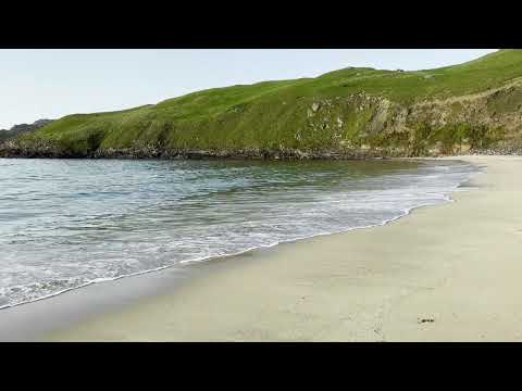
Cliff Beach Isle of Lewis 4K Video
Beautiful remote beach in Lewis and Harris Scotland, Sept. 2023. Wait til the end for photo of beach from above taken at golden ...

Kneep, Isle of Lewis
Kneep (Scottish Gaelic: Cnìp) is a village on the Isle of Lewis, in the Outer Hebrides, Scotland. Kneep is within the parish of Uig.
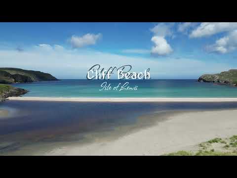
Cliff Beach - Isle of Lewis - Outer Hebrides - Scotland | 4K | DJI Mini 3 Pro
Cliff Beach is located on the western side of Isle of Lewis (Outer Hebrides in Scotland). It is beautiful stretch of light cream sand ...
Nearby Amenities
Located within 500m of 58.212319,-6.9423857Have you been to Cnoc a' Loch?
Leave your review of Cnoc a' Loch below (or comments, questions and feedback).