Aird nan Sgalag

Hill, Mountain in Ross-shire

Scotland

Aird nan Sgalag

Lazy Beds at Tràigh na Beirigh Ridges formed by hand digging of fields.  These one are unusual in that some of the ridges are lined with small stones.
Lazy Beds at Tràigh na Beirigh Credit: Sandy Gerrard

Aird nan Sgalag is a prominent hill located in the county of Ross-shire in the Scottish Highlands. It is situated in the northwest part of the county, near the village of Aultbea. The hill is part of the breathtaking landscape of the Torridon Mountain Range, known for its rugged terrain and stunning vistas.

Standing at an elevation of approximately 563 meters (1,847 feet), Aird nan Sgalag offers magnificent panoramic views of the surrounding area. On a clear day, visitors can enjoy vistas of the nearby Loch Ewe, the Isle of Skye, and the distant mountains of Torridon.

The hill is a popular destination for hikers and nature enthusiasts, who are drawn to its natural beauty and tranquil atmosphere. The ascent of Aird nan Sgalag is relatively moderate, making it accessible to a wide range of abilities. The path to the summit is well-defined, although caution is advised as the terrain can be uneven and slippery in certain areas.

Wildlife is abundant in the area surrounding Aird nan Sgalag, with red deer, golden eagles, and mountain hares being commonly spotted. The hill is also home to a variety of plant species, including heather and juniper.

Overall, Aird nan Sgalag is a captivating hill that offers visitors the opportunity to immerse themselves in the stunning Scottish Highlands landscape and enjoy breathtaking views of the surrounding area.

If you have any feedback on the listing, please let us know in the comments section below.

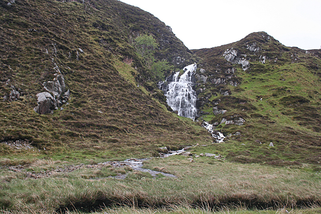
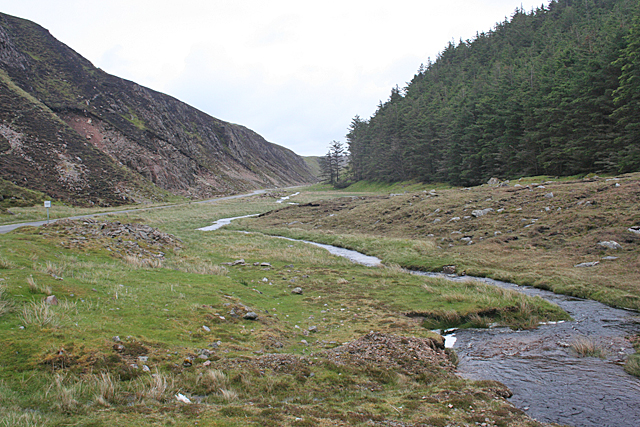
Aird nan Sgalag Images

Images are sourced within 2km of 58.200751/-6.955328 or Grid Reference NB0834. Thanks to Geograph Open Source API. All images are credited.

Lazy Beds at Tràigh na Beirigh Ridges formed by hand digging of fields.  These one are unusual in that some of the ridges are lined with small stones.
Lazy Beds at Tràigh na Beirigh
Ridges formed by hand digging of fields. These one are unusual in that some of the ridges are lined with small stones.
An Sùileachan Monument A monument to the Lewis land clearances <span class="nowrap"><a title="https://bhaltostrust.co.uk/suileachan-project/" rel="nofollow ugc noopener" href="https://bhaltostrust.co.uk/suileachan-project/">Link</a><img style="margin-left:2px;" alt="External link" title="External link - shift click to open in new window" src="https://s1.geograph.org.uk/img/external.png" width="10" height="10"/></span>
An Sùileachan Monument
A monument to the Lewis land clearances LinkExternal link
A slipway in Loch Miabhaig
A' Bheirigh from Suaineabhal
Lochan at Cragavig An old boundary wall snakes across the moorland
Lochan at Cragavig
An old boundary wall snakes across the moorland
Cerishader: postbox № HS2 158 A small postbox on the B8011, with its back to Loch Ròg. It is emptied at 9 o'clock each morning, except Sunday.
Cerishader: postbox № HS2 158
A small postbox on the B8011, with its back to Loch Ròg. It is emptied at 9 o'clock each morning, except Sunday.
A' Bheirigh
A' Bheirigh
Carishader postbox The sea inlet is part of Loch Ròg.
Carishader postbox
The sea inlet is part of Loch Ròg.
Old black house walls, Cairisiadar Looking up An Gleann Ruadh.
Old black house walls, Cairisiadar
Looking up An Gleann Ruadh.
Gleann Bhaltois (Glen Valtos) 5 Gleann Bhaltois is a spectacular example of a glacial meltwater channel. At the end of the last Ice Age, about 10,000 years ago, there is thought to have been a lake where Uig Bay now lies, dammed by ice to the west. The outlet from the lake was at the head of what is now Gleann Bhaltois, and carved a deep steep-sided glen, exploiting a fault line in the rocks. Following several wet days, a waterfall is draining the moor above.
Gleann Bhaltois (Glen Valtos) 5
Gleann Bhaltois is a spectacular example of a glacial meltwater channel. At the end of the last Ice Age, about 10,000 years ago, there is thought to have been a lake where Uig Bay now lies, dammed by ice to the west. The outlet from the lake was at the head of what is now Gleann Bhaltois, and carved a deep steep-sided glen, exploiting a fault line in the rocks. Following several wet days, a waterfall is draining the moor above.
Gleann Bhaltois (Glen Valtos) 6 Gleann Bhaltois is a spectacular example of a glacial meltwater channel. At the end of the last Ice Age, about 10,000 years ago, there is thought to have been a lake where Uig Bay now lies, dammed by ice to the west. The outlet from the lake was at the head of what is now Gleann Bhaltois, and carved a deep steep-sided glen, exploiting a fault line in the rocks. At this point, the glen steps down from its winding upper course through a rock fall to the much straighter lower course.
Gleann Bhaltois (Glen Valtos) 6
Gleann Bhaltois is a spectacular example of a glacial meltwater channel. At the end of the last Ice Age, about 10,000 years ago, there is thought to have been a lake where Uig Bay now lies, dammed by ice to the west. The outlet from the lake was at the head of what is now Gleann Bhaltois, and carved a deep steep-sided glen, exploiting a fault line in the rocks. At this point, the glen steps down from its winding upper course through a rock fall to the much straighter lower course.
Gleann Bhaltois (Glen Valtos) 7 Gleann Bhaltois is a spectacular example of a glacial meltwater channel. At the end of the last Ice Age, about 10,000 years ago, there is thought to have been a lake where Uig Bay now lies, dammed by ice to the west. The outlet from the lake was at the head of what is now Gleann Bhaltois, and carved a deep steep-sided glen, exploiting a fault line in the rocks. From this point, the glen follows the straight line of the fault. The classic and diagnostic feature of a meltwater channel, well seen in this view, is that the stream it contains is too small to have carved it in the first place.
Gleann Bhaltois (Glen Valtos) 7
Gleann Bhaltois is a spectacular example of a glacial meltwater channel. At the end of the last Ice Age, about 10,000 years ago, there is thought to have been a lake where Uig Bay now lies, dammed by ice to the west. The outlet from the lake was at the head of what is now Gleann Bhaltois, and carved a deep steep-sided glen, exploiting a fault line in the rocks. From this point, the glen follows the straight line of the fault. The classic and diagnostic feature of a meltwater channel, well seen in this view, is that the stream it contains is too small to have carved it in the first place.
Gleann Bhaltois (Glen Valtos) 7 Gleann Bhaltois is a spectacular example of a glacial meltwater channel. At the end of the last Ice Age, about 10,000 years ago, there is thought to have been a lake where Uig Bay now lies, dammed by ice to the west. The outlet from the lake was at the head of what is now Gleann Bhaltois, and carved a deep steep-sided glen, exploiting a fault line in the rocks.
Gleann Bhaltois (Glen Valtos) 7
Gleann Bhaltois is a spectacular example of a glacial meltwater channel. At the end of the last Ice Age, about 10,000 years ago, there is thought to have been a lake where Uig Bay now lies, dammed by ice to the west. The outlet from the lake was at the head of what is now Gleann Bhaltois, and carved a deep steep-sided glen, exploiting a fault line in the rocks.
Name That Tune This cheerful accordionist stands just inside a field by the cattle grid on the B8011 north of Cairisiadar. The label at his feet reads 'Name That Tune'.
Name That Tune
This cheerful accordionist stands just inside a field by the cattle grid on the B8011 north of Cairisiadar. The label at his feet reads 'Name That Tune'.
Cairisiadar (Carishader) Though the B8011 has been much improved, there are still some single-track stretches, notably where it crosses narrow bridges which have not been rebuilt, as here at Cairisiadar.
Cairisiadar (Carishader)
Though the B8011 has been much improved, there are still some single-track stretches, notably where it crosses narrow bridges which have not been rebuilt, as here at Cairisiadar.
Miabhaig harbour pontoon View from RIB afloat to pontoon at Miabhaig, Ceann A Tuath Na Hearadh (North Harris).  Compare to <a href="https://www.geograph.org.uk/photo/575251">NB0934 : Miabhaig Jetty</a> taken by Dave Fergusson on 1 Oct 2007.
Miabhaig harbour pontoon
View from RIB afloat to pontoon at Miabhaig, Ceann A Tuath Na Hearadh (North Harris). Compare to NB0934 : Miabhaig Jetty taken by Dave Fergusson on 1 Oct 2007.
Show me another place!

Aird nan Sgalag is located at Grid Ref: NB0834 (Lat: 58.200751, Lng: -6.955328)

Unitary Authority: Na h-Eileanan an Iar

Police Authority: Highlands and Islands

What 3 Words

///salt.owners.daydreams. Near Carloway, Na h-Eileanan Siar

Related Wikis

Loch na Berie

Loch Na Berie is a broch in the Outer Hebrides of Scotland, located approximately 400 yards from the shore, and is thought to have been located on an island...

Flodaigh, Lewis

Flodaigh is a small island in Loch Roag on the west coast of Lewis in the Outer Hebrides of Scotland. It is about 33 hectares (82 acres) in extent and...

Cliff, Lewis

Cliff (Scottish Gaelic: Cliobh) is a small settlement on the Isle of Lewis, in the Outer Hebrides, Scotland. Cliff is within the parish of Uig. The settlement...

Kneep

Kneep (Scottish Gaelic: Cnìp) is a village on the Isle of Lewis, in the Outer Hebrides, Scotland. Kneep is within the parish of Uig.Various archaeological...

Nearby Amenities

Located within 500m of 58.200751,-6.955328
Passing Place
Lat/Long: 58.1985659/-6.952369
Passing Place
Lat/Long: 58.2036172/-6.9536011
Barrier: cattle_grid
Lat/Long: 58.2013388/-6.9546299
Leisure: slipway
Lat/Long: 58.2020107/-6.953176
Leisure: slipway
Lat/Long: 58.2034502/-6.9543832
Restaurant
Scallop
Lat/Long: 58.2017993/-6.9530219
Miabhaig
Name En: Miavaig
Name Gd: Miabhaig
Place: village
Lat/Long: 58.2029652/-6.9596178
Passing Place
Lat/Long: 58.1996054/-6.9530129
Passing Place
Lat/Long: 58.2013676/-6.9572234
Power: pole
Lat/Long: 58.197517/-6.9509146
Power: pole
Lat/Long: 58.1981776/-6.9514386
Power: pole
Lat/Long: 58.1986777/-6.9518375
Power: pole
Lat/Long: 58.199407/-6.9524133
Power: pole
Lat/Long: 58.2000418/-6.9531922
Power: pole
Lat/Long: 58.2007166/-6.9539865
Power: pole
Lat/Long: 58.2010722/-6.956996
Power: pole
Lat/Long: 58.2017695/-6.9539218
Power: pole
Lat/Long: 58.2011631/-6.9582835
Power: pole
Lat/Long: 58.2012137/-6.9590604
Power: pole
Lat/Long: 58.2013231/-6.9603582
Power: pole
Lat/Long: 58.2016505/-6.9607994
Power: pole
Lat/Long: 58.2021642/-6.9614727
Power: pole
Lat/Long: 58.2029096/-6.9624099
Power: pole
Lat/Long: 58.2050127/-6.9539989
Power: pole
Lat/Long: 58.2046651/-6.9526775
Power: pole
Lat/Long: 58.2042204/-6.9515696
Power: pole
Lat/Long: 58.2037116/-6.950312
Power: pole
Lat/Long: 58.2036499/-6.9492602
Power: pole
Lat/Long: 58.2020319/-6.9472198
Power: pole
Lat/Long: 58.203111/-6.950273
Power: pole
Lat/Long: 58.2031656/-6.9494458
Power: pole
Lat/Long: 58.2032185/-6.9487095
Passing Place
Lat/Long: 58.2041045/-6.9543398
Passing Place
Lat/Long: 58.2045401/-6.9549891
Barrier: cattle_grid
Lat/Long: 58.2014886/-6.9560943
Power: pole
Lat/Long: 58.2013561/-6.954735
Power: pole
Lat/Long: 58.2009226/-6.9556832
Power: pole
Lat/Long: 58.2012302/-6.9555702
Power: pole
Lat/Long: 58.2011515/-6.9561351
Power: pole
Lat/Long: 58.2011093/-6.9569539
Power: pole
Lat/Long: 58.200842/-6.9550196
Power: pole
Lat/Long: 58.2012624/-6.9576926
Power: pole
Lat/Long: 58.2014127/-6.9583933
Power: pole
Lat/Long: 58.2016481/-6.9586921
The data included in this document is from www.openstreetmap.org. The data is made available under ODbL.

Have you been to Aird nan Sgalag?

Leave your review of Aird nan Sgalag below (or comments, questions and feedback).