Beidig
Hill, Mountain in Inverness-shire
Scotland
Beidig

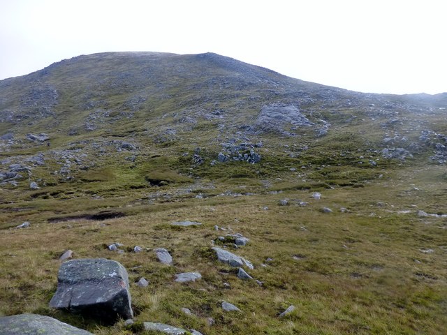
Beidig is a prominent hill located in the region of Inverness-shire, Scotland. Standing at an impressive height of approximately 2,217 feet (675 meters), it offers breathtaking panoramic views of the surrounding landscape. Beidig is situated within the Great Glen, a geological fault line that stretches from Inverness to Fort William. This makes it a popular destination for hikers, nature enthusiasts, and climbers.
The hill is characterized by its rugged terrain, with steep slopes and rocky outcrops. Its summit is marked by a cairn, which serves as a point of reference for visitors. From the top, one can enjoy sweeping vistas of the nearby Loch Ness, the Caledonian Canal, and the stunning Scottish Highlands.
Beidig is home to a diverse range of flora and fauna, including heather, bracken, and a variety of bird species such as red grouse and peregrine falcons. The area surrounding the hill is also rich in history, with remnants of ancient settlements and burial sites scattered throughout the landscape.
Due to its accessibility and natural beauty, Beidig attracts a steady stream of visitors all year round. Hiking trails of varying difficulty levels offer opportunities for both seasoned climbers and beginners to explore the hill’s natural wonders. The surrounding area also offers ample accommodation options, ranging from cozy bed and breakfasts to luxury hotels, making it an ideal base for those wishing to discover the wonders of Inverness-shire.
If you have any feedback on the listing, please let us know in the comments section below.
Beidig Images
Images are sourced within 2km of 57.988229/-7.0218374 or Grid Reference NB0310. Thanks to Geograph Open Source API. All images are credited.


![Ceartaval [Ceartabhal] Second subMarilyn today in mixed weather with the magnificent seven in mixed weather.
Name: Ceartaval [Ceartabhal]
Hill number: 1593
Height: 556m / 1824ft
Area: 24B: Harris and Nearby Islands
Class: Hu,5H,sMa
Grid ref: NB 04262 12675
Summit feature: rock
Drop: 145m
Col: 411m NB049125](https://s0.geograph.org.uk/geophotos/03/69/52/3695208_0cce8fdf.jpg)
![View Towards Ceartabhal A lovely view towards Ceartaval [Ceartabhal] which captures all that is good about hill walking on the Isle of Harris.](https://s1.geograph.org.uk/geophotos/03/69/52/3695221_e1ae2c0b.jpg)


![Leosaval [Leosabhal] First subMarilyn of 3 today with Alan Holmes, George Morl, Iain Brown, Martin Richardson, Jim Bloomer and Michael Earnshaw in mixed weather. A lovely viewpoint for Taransay.
Name: Leosaval [Leosabhal]
Hill number: 1598
Height: 412m / 1352ft
Area: 24B: Harris and Nearby Islands
Class: Hu,4,sMa
Grid ref: NB038098 (est)
Drop: 143m
Col: 269m NB034107](https://s1.geograph.org.uk/geophotos/03/69/51/3695153_86f4216f.jpg)
![Leosaval [Leosabhal] Boulder And Rainbow Name: Leosaval [Leosabhal]
Hill number: 1598
Height: 412m / 1352ft
Area: 24B: Harris and Nearby Islands
Class: Hu,4,sMa
Grid ref: NB038098 (est)
Drop: 143m
Col: 269m NB034107](https://s0.geograph.org.uk/geophotos/03/69/51/3695164_94071cad.jpg)

Beidig is located at Grid Ref: NB0310 (Lat: 57.988229, Lng: -7.0218374)
Unitary Authority: Na h-Eileanan an Iar
Police Authority: Highlands and Islands
What 3 Words
///royally.savers.banquets. Near Tarbert, Na h-Eileanan Siar
Nearby Locations
Related Wikis

Tiorga Mor
Tiorga Mor (679 m) is a mountain in Harris, in the Outer Hebrides of Scotland. The most westerly peak of the high mountains of Harris, it is a very rugged...

Amhuinnsuidhe
Amhuinnsuidhe (Scottish Gaelic: Abhainn Suidhe) is a settlement on Harris, in the Outer Hebrides, Scotland. The settlement is also within the parish of...

Chliostair Hydro-Electric Scheme
Chliostair Hydro-Electric Scheme is a small scheme promoted by the North of Scotland Hydro-Electric Board on Harris, Outer Hebrides. It consists of a single...

Amhuinnsuidhe Castle
Amhuinnsuidhe Castle is a large 19th-century private country house on Harris, one of the Western Isles of Scotland. It was designated as a Category A listed...
Have you been to Beidig?
Leave your review of Beidig below (or comments, questions and feedback).