Sudhanais
Hill, Mountain in Inverness-shire
Scotland
Sudhanais

Sudhanais is a picturesque hill located in Inverness-shire, Scotland. It is part of the stunning Scottish Highlands region, renowned for its breathtaking landscapes and rugged beauty. Rising to a height of approximately 1,248 feet (380 meters), Sudhanais offers hikers and nature enthusiasts an opportunity to immerse themselves in the tranquility of the surrounding countryside.
The hill is characterized by its distinctive shape, with a gently sloping ascent leading up to a prominent summit. The terrain is predominantly rocky and covered in heather, providing a rich tapestry of colors throughout the year. Sudhanais is particularly stunning during the summer months when the heather is in full bloom, painting the landscape with vibrant shades of purple and pink.
From the summit of Sudhanais, visitors are rewarded with panoramic views of the surrounding area. On clear days, it is possible to see the majestic peaks of nearby mountains such as Ben Wyvis and Ben Nevis. The hill also offers a glimpse into the region's rich history, with remnants of ancient settlements and cairns scattered across its slopes.
Hiking and walking are popular activities on Sudhanais, with a variety of trails catering to different levels of fitness and experience. The hill is accessible from various starting points, and a network of well-marked paths guides visitors through its diverse terrain.
Sudhanais is a hidden gem in the Scottish Highlands, offering visitors a chance to connect with nature and soak in the unmatched beauty of Inverness-shire. Whether it's a leisurely stroll or a challenging hike, Sudhanais has something to offer for everyone seeking an authentic Highland experience.
If you have any feedback on the listing, please let us know in the comments section below.
Sudhanais Images
Images are sourced within 2km of 57.68771/-7.2194799 or Grid Reference NF8978. Thanks to Geograph Open Source API. All images are credited.

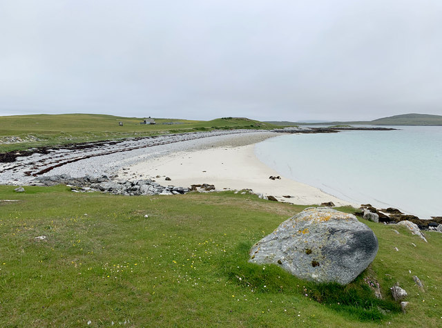
![Oystercatchers on the beach You are never far away from the sight or loud piping of oystercatchers on the Western Isles. This view is south towards the small island of Lingeigh [to the right] with the hills of North Uist beyond.](https://s3.geograph.org.uk/geophotos/06/21/07/6210727_b324520c.jpg)

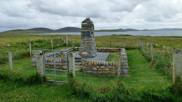


![The 'Giant MacAskill' memorial. Angus MacAskill [born on Berneray in 1825]was indeed a giant of a man. The memorial is the same height as he was [7ft 9&quot;/ 2.38m], whilst he weighed 193kg. At the age of 24 he toured with Barnum and Bailey&#039;s circus, and there are more details of his life in the museum at Dunvegan on Skye.](https://s3.geograph.org.uk/photos/50/46/504679_a2374ba5.jpg)
Sudhanais is located at Grid Ref: NF8978 (Lat: 57.68771, Lng: -7.2194799)
Unitary Authority: Na h-Eileanan an Iar
Police Authority: Highlands and Islands
What 3 Words
///euphoric.perusing.perform. Near Lochmaddy, Na h-Eileanan Siar
Nearby Locations
Related Wikis

Newtonferry
Newtonferry (Scottish Gaelic: Port nan Long, "the harbour of the ships") is a small crofting community on the island of North Uist in the Western Isles...

Dun an Sticir
Dun an Sticir (Scottish Gaelic: Dùn an Sticir [ˈt̪un əɲ ˈʃtʲiçkʲɪɾʲ]) is an Iron Age broch situated approximately 9.5 kilometers north of Lochmaddy in...

North Uist Machair and Islands
The North Uist Machair and Islands is a protected wetland area in the Outer Hebrides of Scotland. A total of 4,705 hectares comprises seven separate areas...

Otternish
Otternish is the former North Uist terminal for the ferry to Berneray, in the Outer Hebrides, Scotland. The slipway lies 6 miles (10 km) north of Lochmaddy...
Nearby Amenities
Located within 500m of 57.68771,-7.2194799Have you been to Sudhanais?
Leave your review of Sudhanais below (or comments, questions and feedback).