Back o' the World
Downs, Moorland in Ayrshire
Scotland
Back o' the World
Back o' the World is a rural area located in Ayrshire, Scotland, known for its breathtaking downs and moorland landscapes. Situated amidst rolling hills and vast open spaces, it offers a tranquil and idyllic setting for nature enthusiasts and hikers alike.
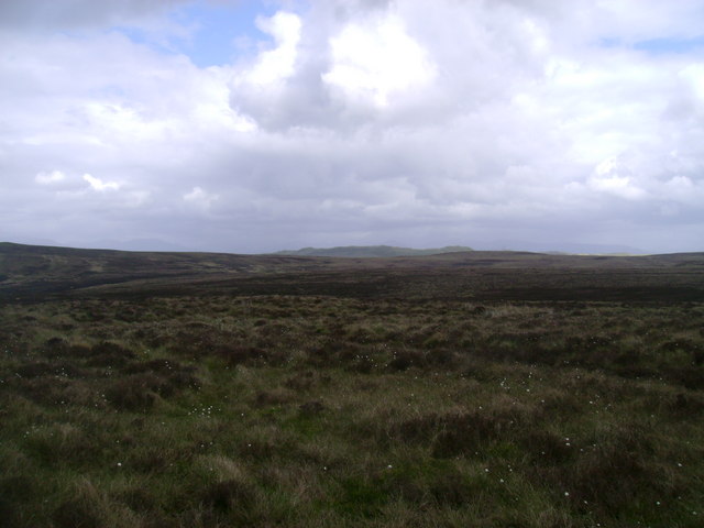
The downs of Back o' the World are characterized by their gently sloping terrain, covered with lush green grass and scattered with vibrant wildflowers during the spring and summer months. The area provides an excellent vantage point to admire the surrounding countryside, with panoramic views stretching out for miles.
The moorland, on the other hand, showcases a more rugged and untamed beauty. Covered in heather and bracken, it is dotted with numerous small lochs and streams, creating a diverse habitat for various bird species and other wildlife. The moorland is also home to a variety of plant species, including cotton grass and bog moss.
Back o' the World offers numerous walking trails and paths, allowing visitors to explore its natural wonders at their own pace. These routes take you through peaceful woodlands, past tranquil lochs, and up to the hilltops, where you can take in the stunning views of the surrounding countryside.
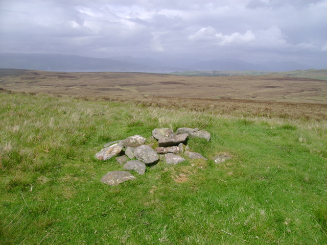
The area is also steeped in history, with several ancient sites and ruins scattered throughout. These include standing stones, burial cairns, and remnants of old settlements, offering a glimpse into the region's rich past.
Overall, Back o' the World in Ayrshire is a picturesque and unspoiled landscape, offering a peaceful retreat for those seeking to connect with nature and immerse themselves in the beauty of Scotland's countryside.
If you have any feedback on the listing, please let us know in the comments section below.
Back o' the World Images
Images are sourced within 2km of 55.890003/-4.8036234 or Grid Reference NS2469. Thanks to Geograph Open Source API. All images are credited.


Back o' the World is located at Grid Ref: NS2469 (Lat: 55.890003, Lng: -4.8036234)
Unitary Authority: North Ayrshire
Police Authority: Ayrshire
Also known as: Ferret of Keith
What 3 Words
///dimes.snore.importing. Near Inverkip, Inverclyde
Nearby Locations
Related Wikis

Loch Thom
Loch Thom is a reservoir which since 1827 has provided a water supply to the town of Greenock in Inverclyde, Scotland. It is named after the civil engineer...

Inverclyde (UK Parliament constituency)
Inverclyde is a parliamentary constituency of the House of Commons of the Parliament of the United Kingdom. It replaced Greenock and Inverclyde and the...

Inverclyde
Inverclyde (Scots: Inerclyde, Scottish Gaelic: Inbhir Chluaidh, pronounced [iɲiɾʲˈxl̪ˠuəj], "mouth of the Clyde") is one of 32 council areas used for local...

Gryffe Reservoirs
The Gryffe Reservoirs, also spelled 'Gryfe', take their name from the River Gryffe, name deriving from the Gaelic garbh meaning "rough stream". are two...

Inverkip
Inverkip (; Scottish Gaelic: Inbhir Chip) is a village and parish in the Inverclyde council area and historic county of Renfrewshire in the west central...

IBM railway station
IBM railway station (formerly known as IBM Halt) is a currently disused railway station on the Inverclyde Line, 25+1⁄2 miles (41 km) west of Glasgow Central...

Inverkip railway station
Inverkip railway station is a railway station serving the village of Inverkip, Inverclyde, Scotland. The station is managed by ScotRail and is on the Inverclyde...
Spango Valley
Spango Valley is a steep sided valley to the south-west of Greenock, Scotland. It runs approximately south west to north east for around 2.4 km (1.5 mi...
Nearby Amenities
Located within 500m of 55.890003,-4.8036234Have you been to Back o' the World?
Leave your review of Back o' the World below (or comments, questions and feedback).