Bedford Level (South Level)
Downs, Moorland in Cambridgeshire East Cambridgeshire
England
Bedford Level (South Level)

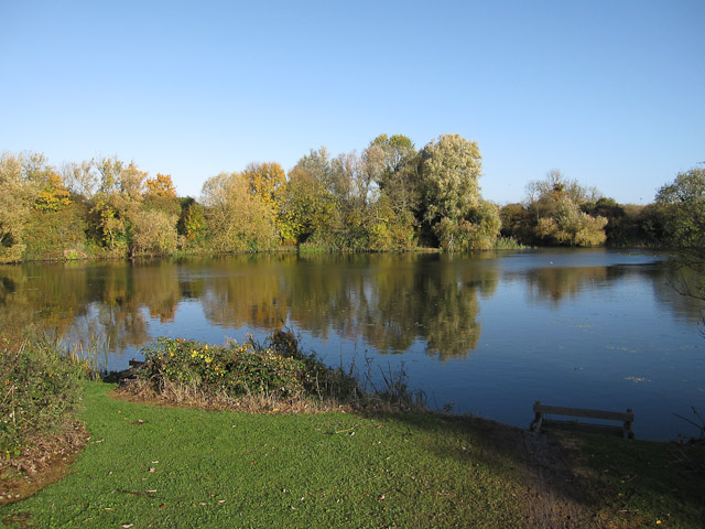
Bedford Level, also known as the South Level, is an area located in Cambridgeshire, England. It is situated in the eastern part of the county, near the town of Downham Market. The region is known for its flat and marshy terrain, characterized by low-lying moorland and fenland.
Covering an area of approximately 200 square miles, Bedford Level is intersected by several rivers, including the River Great Ouse, the River Nene, and the River Wissey. These waterways have played a significant role in shaping the landscape, as well as providing a means of transportation and drainage.
The fenland in Bedford Level is rich in biodiversity, supporting a variety of plant and animal species. The area is home to several nature reserves, including the Welney Wetland Centre and the RSPB Ouse Washes, which attract birdwatchers and wildlife enthusiasts.
Historically, Bedford Level has been subject to extensive drainage efforts to reclaim the land for agriculture. The Bedford Level Corporation, established in 1663, was responsible for overseeing the construction and maintenance of drainage channels and embankments. These efforts have transformed the area into fertile farmland, primarily used for arable farming and livestock grazing.
Bedford Level is also notable for its engineering achievements. The Old Bedford River and the New Bedford River, both artificial channels, were created in the 17th century to improve drainage and prevent flooding. The region is now protected by a complex network of flood defense systems, including sluices and pumping stations, ensuring the safety of the surrounding communities.
If you have any feedback on the listing, please let us know in the comments section below.
Bedford Level (South Level) Images
Images are sourced within 2km of 52.399634/0.29163158 or Grid Reference TL5680. Thanks to Geograph Open Source API. All images are credited.


Bedford Level (South Level) is located at Grid Ref: TL5680 (Lat: 52.399634, Lng: 0.29163158)
Division: Isle of Ely
Administrative County: Cambridgeshire
District: East Cambridgeshire
Police Authority: Cambridgeshire
What 3 Words
///throwaway.obtain.always. Near Ely, Cambridgeshire
Nearby Locations
Related Wikis

Isle of Ely Rowing Club
Isle of Ely Rowing Club is a rowing club on the River Great Ouse based at Kiln Lane, Prickwillow Road, Ely, Cambridgeshire.The club was founded in 2004...
Ely Pits and Meadows
Ely Pits and Meadows is an 85.8-hectare (212-acre) Site of Special Scientific Interest (SSSI) on the eastern outskirts of Ely in Cambridgeshire. It is...

Roswell Pits
Roswell Pits is an 8 hectare nature reserve on the eastern outskirts of Ely in Cambridgeshire. It is managed by the Environment Agency. It is part of the...
The Boat Race 2021
The Boat Race 2021 was an event comprising two side-by-side rowing races that took place on 4 April 2021. The Boat Race is contested annually between crews...
Queen Adelaide, Cambridgeshire
Queen Adelaide is a hamlet on the River Great Ouse in the Fens about 1+1⁄2 miles (2.4 km) northeast of Ely, Cambridgeshire, England. The hamlet is named...

East Cambridgeshire
East Cambridgeshire (locally known as East Cambs) is a local government district in Cambridgeshire, England. Its council is based in the city of Ely. The...

Princess of Wales Hospital, Ely
The Princess of Wales Hospital is a healthcare facility in Ely, Cambridgeshire. It is managed by the Cambridgeshire and Peterborough NHS Foundation Trust...

Ely Cathedral
Ely Cathedral, formally the Cathedral Church of the Holy and Undivided Trinity, is an Anglican cathedral in the city of Ely, Cambridgeshire, England. The...
Nearby Amenities
Located within 500m of 52.399634,0.29163158Have you been to Bedford Level (South Level)?
Leave your review of Bedford Level (South Level) below (or comments, questions and feedback).