Saxon Down
Downs, Moorland in Sussex Lewes
England
Saxon Down
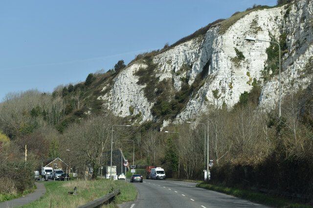
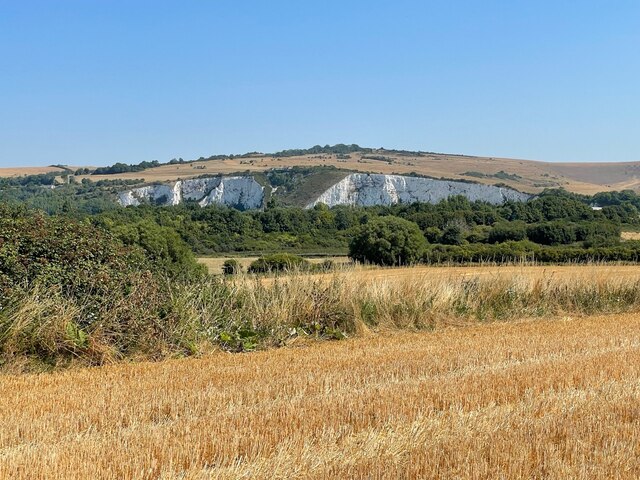
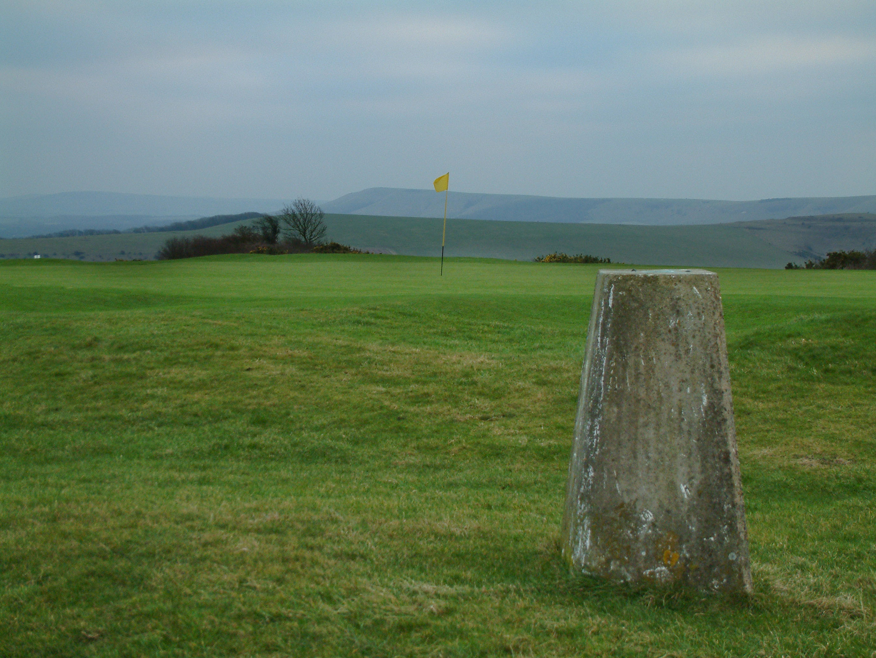
Saxon Down, located in Sussex, England, is a picturesque area encompassing both downs and moorland landscapes. Stretching across rolling hills and valleys, it offers breathtaking views and a diverse range of natural features. The region is known for its unique flora and fauna, making it a popular destination for nature enthusiasts and hikers.
The downs in Saxon Down are characterized by their gently sloping hills and grassy pastures. These open spaces provide ample opportunities for outdoor activities such as walking, picnicking, and photography. The rich biodiversity of this area includes various species of wildflowers, butterflies, and birds, making it a haven for wildlife lovers.
In contrast, the moorland in Saxon Down offers a different experience. Characterized by its heather-covered hills and peat bogs, this landscape provides a stark and rugged beauty. Moorland walks allow visitors to immerse themselves in the unique atmosphere and enjoy the tranquility of the surroundings.
Saxon Down is also home to several historical and archaeological sites. Ancient burial mounds, known as barrows, dot the landscape, offering a glimpse into the area's rich history. These sites provide valuable insights into the lives and customs of the people who once inhabited this region.
Overall, Saxon Down in Sussex offers a diverse and captivating natural environment. Its combination of downs and moorland, along with its historical significance, make it an ideal destination for those seeking both natural beauty and cultural exploration.
If you have any feedback on the listing, please let us know in the comments section below.
Saxon Down Images
Images are sourced within 2km of 50.873318/0.048658228 or Grid Reference TQ4410. Thanks to Geograph Open Source API. All images are credited.
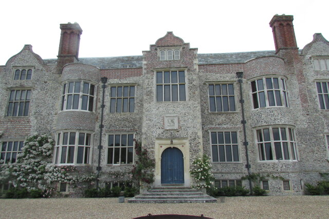
![Glynde Place [1] From the car parking area, this grassy path leads through the gardens to the house.
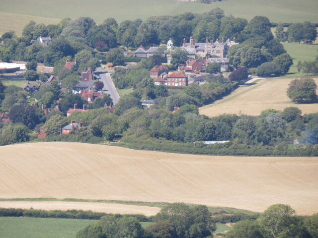
The Glynde Place estate is situated at the top of the village of Glynde, some 2½ miles east of Lewes. The house was built in 1569 from local flint, chalk and Caen stone. The estate has 10 acres of garden and 74 acres of parkland. The house is listed, grade I, with details at: <span class="nowrap"><a title="https://historicengland.org.uk/listing/the-list/list-entry/1221546" rel="nofollow ugc noopener" href="https://historicengland.org.uk/listing/the-list/list-entry/1221546">Link</a><img style="margin-left:2px;" alt="External link" title="External link - shift click to open in new window" src="https://s1.geograph.org.uk/img/external.png" width="10" height="10"/></span> The grounds are on the Register of Historic Parks and Gardens. Grade II*, with much history and detail at:
<span class="nowrap"><a title="https://historicengland.org.uk/listing/the-list/list-entry/1000307" rel="nofollow ugc noopener" href="https://historicengland.org.uk/listing/the-list/list-entry/1000307">Link</a><img style="margin-left:2px;" alt="External link" title="External link - shift click to open in new window" src="https://s1.geograph.org.uk/img/external.png" width="10" height="10"/></span>](https://s1.geograph.org.uk/geophotos/07/22/39/7223997_32bfd076.jpg)
![Glynde Place [2] The house is seen from the approach path from the car park.
The Glynde Place estate is situated at the top of the village of Glynde, some 2½ miles east of Lewes. The house was built in 1569 from local flint, chalk and Caen stone. The estate has 10 acres of garden and 74 acres of parkland. The house is listed, grade I, with details at: <span class="nowrap"><a title="https://historicengland.org.uk/listing/the-list/list-entry/1221546" rel="nofollow ugc noopener" href="https://historicengland.org.uk/listing/the-list/list-entry/1221546">Link</a><img style="margin-left:2px;" alt="External link" title="External link - shift click to open in new window" src="https://s1.geograph.org.uk/img/external.png" width="10" height="10"/></span> The grounds are on the Register of Historic Parks and Gardens. Grade II*, with much history and detail at:
<span class="nowrap"><a title="https://historicengland.org.uk/listing/the-list/list-entry/1000307" rel="nofollow ugc noopener" href="https://historicengland.org.uk/listing/the-list/list-entry/1000307">Link</a><img style="margin-left:2px;" alt="External link" title="External link - shift click to open in new window" src="https://s1.geograph.org.uk/img/external.png" width="10" height="10"/></span>](https://s0.geograph.org.uk/geophotos/07/22/40/7224000_f05209ec.jpg)
![Glynde Place [3] The east front of the house.
The Glynde Place estate is situated at the top of the village of Glynde, some 2½ miles east of Lewes. The house was built in 1569 from local flint, chalk and Caen stone. The estate has 10 acres of garden and 74 acres of parkland. The house is listed, grade I, with details at: <span class="nowrap"><a title="https://historicengland.org.uk/listing/the-list/list-entry/1221546" rel="nofollow ugc noopener" href="https://historicengland.org.uk/listing/the-list/list-entry/1221546">Link</a><img style="margin-left:2px;" alt="External link" title="External link - shift click to open in new window" src="https://s1.geograph.org.uk/img/external.png" width="10" height="10"/></span> The grounds are on the Register of Historic Parks and Gardens. Grade II*, with much history and detail at:
<span class="nowrap"><a title="https://historicengland.org.uk/listing/the-list/list-entry/1000307" rel="nofollow ugc noopener" href="https://historicengland.org.uk/listing/the-list/list-entry/1000307">Link</a><img style="margin-left:2px;" alt="External link" title="External link - shift click to open in new window" src="https://s1.geograph.org.uk/img/external.png" width="10" height="10"/></span>](https://s3.geograph.org.uk/geophotos/07/22/40/7224003_5478c9f8.jpg)
![Glynde Place [4] The garden wall and gate piers were built in 1760. On one side the wall is faced with squared knapped flints with blind arches of red brick and gate piers of squared knapped flints edged with red brick. The other side of the wall is faced with cobbles and the gate piers are wholly of red brick. The piers are crowned with a lead figure of a wyvern. Listed, grade II*, with details at: <span class="nowrap"><a title="https://historicengland.org.uk/listing/the-list/list-entry/1043919" rel="nofollow ugc noopener" href="https://historicengland.org.uk/listing/the-list/list-entry/1043919">Link</a><img style="margin-left:2px;" alt="External link" title="External link - shift click to open in new window" src="https://s1.geograph.org.uk/img/external.png" width="10" height="10"/></span>
The Glynde Place estate is situated at the top of the village of Glynde, some 2½ miles east of Lewes. The house was built in 1569 from local flint, chalk and Caen stone. The estate has 10 acres of garden and 74 acres of parkland. The house is listed, grade I, with details at: <span class="nowrap"><a title="https://historicengland.org.uk/listing/the-list/list-entry/1221546" rel="nofollow ugc noopener" href="https://historicengland.org.uk/listing/the-list/list-entry/1221546">Link</a><img style="margin-left:2px;" alt="External link" title="External link - shift click to open in new window" src="https://s1.geograph.org.uk/img/external.png" width="10" height="10"/></span> The grounds are on the Register of Historic Parks and Gardens. Grade II*, with much history and detail at:
<span class="nowrap"><a title="https://historicengland.org.uk/listing/the-list/list-entry/1000307" rel="nofollow ugc noopener" href="https://historicengland.org.uk/listing/the-list/list-entry/1000307">Link</a><img style="margin-left:2px;" alt="External link" title="External link - shift click to open in new window" src="https://s1.geograph.org.uk/img/external.png" width="10" height="10"/></span>](https://s1.geograph.org.uk/geophotos/07/22/40/7224005_d61e403d.jpg)
![Glynde Place [5] The garden wall and gate piers were built in 1760. On one side the wall is faced with squared knapped flints with blind arches of red brick and gate piers of squared knapped flints edged with red brick. The other side of the wall is faced with cobbles and the gate piers are wholly of red brick. The piers are crowned with a lead figure of a wyvern. Listed, grade II*, with details at: <span class="nowrap"><a title="https://historicengland.org.uk/listing/the-list/list-entry/1043919" rel="nofollow ugc noopener" href="https://historicengland.org.uk/listing/the-list/list-entry/1043919">Link</a><img style="margin-left:2px;" alt="External link" title="External link - shift click to open in new window" src="https://s1.geograph.org.uk/img/external.png" width="10" height="10"/></span>
The Glynde Place estate is situated at the top of the village of Glynde, some 2½ miles east of Lewes. The house was built in 1569 from local flint, chalk and Caen stone. The estate has 10 acres of garden and 74 acres of parkland. The house is listed, grade I, with details at: <span class="nowrap"><a title="https://historicengland.org.uk/listing/the-list/list-entry/1221546" rel="nofollow ugc noopener" href="https://historicengland.org.uk/listing/the-list/list-entry/1221546">Link</a><img style="margin-left:2px;" alt="External link" title="External link - shift click to open in new window" src="https://s1.geograph.org.uk/img/external.png" width="10" height="10"/></span> The grounds are on the Register of Historic Parks and Gardens. Grade II*, with much history and detail at:
<span class="nowrap"><a title="https://historicengland.org.uk/listing/the-list/list-entry/1000307" rel="nofollow ugc noopener" href="https://historicengland.org.uk/listing/the-list/list-entry/1000307">Link</a><img style="margin-left:2px;" alt="External link" title="External link - shift click to open in new window" src="https://s1.geograph.org.uk/img/external.png" width="10" height="10"/></span>](https://s3.geograph.org.uk/geophotos/07/22/40/7224011_aa5369d4.jpg)
![Glynde Place [6] The stables were built in 1760 and consist of two buildings at right angles to each other, joined by a flanking wall. One of the buildings stands across the carriage drive. Constructed of squared knapped flint with red brick quoins. There is a central carriage arch in red brick. The roof is of slate, with a turret over the archway. Listed, grade I, with details at: <span class="nowrap"><a title="https://historicengland.org.uk/listing/the-list/list-entry/1221605" rel="nofollow ugc noopener" href="https://historicengland.org.uk/listing/the-list/list-entry/1221605">Link</a><img style="margin-left:2px;" alt="External link" title="External link - shift click to open in new window" src="https://s1.geograph.org.uk/img/external.png" width="10" height="10"/></span>
The Glynde Place estate is situated at the top of the village of Glynde, some 2½ miles east of Lewes. The house was built in 1569 from local flint, chalk and Caen stone. The estate has 10 acres of garden and 74 acres of parkland. The house is listed, grade I, with details at: <span class="nowrap"><a title="https://historicengland.org.uk/listing/the-list/list-entry/1221546" rel="nofollow ugc noopener" href="https://historicengland.org.uk/listing/the-list/list-entry/1221546">Link</a><img style="margin-left:2px;" alt="External link" title="External link - shift click to open in new window" src="https://s1.geograph.org.uk/img/external.png" width="10" height="10"/></span> The grounds are on the Register of Historic Parks and Gardens. Grade II*, with much history and detail at:
<span class="nowrap"><a title="https://historicengland.org.uk/listing/the-list/list-entry/1000307" rel="nofollow ugc noopener" href="https://historicengland.org.uk/listing/the-list/list-entry/1000307">Link</a><img style="margin-left:2px;" alt="External link" title="External link - shift click to open in new window" src="https://s1.geograph.org.uk/img/external.png" width="10" height="10"/></span>](https://s1.geograph.org.uk/geophotos/07/22/49/7224997_ec0437aa.jpg)
![Glynde Place [7] Part of the gardens.
The Glynde Place estate is situated at the top of the village of Glynde, some 2½ miles east of Lewes. The house was built in 1569 from local flint, chalk and Caen stone. The estate has 10 acres of garden and 74 acres of parkland. The house is listed, grade I, with details at: <span class="nowrap"><a title="https://historicengland.org.uk/listing/the-list/list-entry/1221546" rel="nofollow ugc noopener" href="https://historicengland.org.uk/listing/the-list/list-entry/1221546">Link</a><img style="margin-left:2px;" alt="External link" title="External link - shift click to open in new window" src="https://s1.geograph.org.uk/img/external.png" width="10" height="10"/></span> The grounds are on the Register of Historic Parks and Gardens. Grade II*, with much history and detail at:
<span class="nowrap"><a title="https://historicengland.org.uk/listing/the-list/list-entry/1000307" rel="nofollow ugc noopener" href="https://historicengland.org.uk/listing/the-list/list-entry/1000307">Link</a><img style="margin-left:2px;" alt="External link" title="External link - shift click to open in new window" src="https://s1.geograph.org.uk/img/external.png" width="10" height="10"/></span>](https://s2.geograph.org.uk/geophotos/07/22/49/7224998_de9dcbdd.jpg)
![Glynde Place [8] The carriage drive leading to the entrance from the road. Seen from the stables.
The Glynde Place estate is situated at the top of the village of Glynde, some 2½ miles east of Lewes. The house was built in 1569 from local flint, chalk and Caen stone. The estate has 10 acres of garden and 74 acres of parkland. The house is listed, grade I, with details at: <span class="nowrap"><a title="https://historicengland.org.uk/listing/the-list/list-entry/1221546" rel="nofollow ugc noopener" href="https://historicengland.org.uk/listing/the-list/list-entry/1221546">Link</a><img style="margin-left:2px;" alt="External link" title="External link - shift click to open in new window" src="https://s1.geograph.org.uk/img/external.png" width="10" height="10"/></span> The grounds are on the Register of Historic Parks and Gardens. Grade II*, with much history and detail at:
<span class="nowrap"><a title="https://historicengland.org.uk/listing/the-list/list-entry/1000307" rel="nofollow ugc noopener" href="https://historicengland.org.uk/listing/the-list/list-entry/1000307">Link</a><img style="margin-left:2px;" alt="External link" title="External link - shift click to open in new window" src="https://s1.geograph.org.uk/img/external.png" width="10" height="10"/></span>](https://s3.geograph.org.uk/geophotos/07/22/49/7224999_39e54a32.jpg)
![Parish church [1] The Anglican parish church of St Mary the Virgin was built in 1765. The entrance front is of knapped flint on an ashlar base with a pediment. The other walls are of cobbles on an ashlar base. The interior retains its original fittings. The gallery was inserted in 1841 and the chancel was repaired in 1894. Listed, grade II*, with details at: <span class="nowrap"><a title="https://historicengland.org.uk/listing/the-list/list-entry/1043918" rel="nofollow ugc noopener" href="https://historicengland.org.uk/listing/the-list/list-entry/1043918">Link</a><img style="margin-left:2px;" alt="External link" title="External link - shift click to open in new window" src="https://s1.geograph.org.uk/img/external.png" width="10" height="10"/></span>
The Glynde Place estate is situated at the top of the village of Glynde, some 2½ miles east of Lewes. The house was built in 1569 from local flint, chalk and Caen stone. The estate has 10 acres of garden and 74 acres of parkland. The house is listed, grade I, with details at: <span class="nowrap"><a title="https://historicengland.org.uk/listing/the-list/list-entry/1221546" rel="nofollow ugc noopener" href="https://historicengland.org.uk/listing/the-list/list-entry/1221546">Link</a><img style="margin-left:2px;" alt="External link" title="External link - shift click to open in new window" src="https://s1.geograph.org.uk/img/external.png" width="10" height="10"/></span> The grounds are on the Register of Historic Parks and Gardens. Grade II*, with much history and detail at:
<span class="nowrap"><a title="https://historicengland.org.uk/listing/the-list/list-entry/1000307" rel="nofollow ugc noopener" href="https://historicengland.org.uk/listing/the-list/list-entry/1000307">Link</a><img style="margin-left:2px;" alt="External link" title="External link - shift click to open in new window" src="https://s1.geograph.org.uk/img/external.png" width="10" height="10"/></span>](https://s2.geograph.org.uk/geophotos/07/22/50/7225002_26126d8d.jpg)
![Glynde Place [9] The view from the house, looking northeast.
The Glynde Place estate is situated at the top of the village of Glynde, some 2½ miles east of Lewes. The house was built in 1569 from local flint, chalk and Caen stone. The estate has 10 acres of garden and 74 acres of parkland. The house is listed, grade I, with details at: <span class="nowrap"><a title="https://historicengland.org.uk/listing/the-list/list-entry/1221546" rel="nofollow ugc noopener" href="https://historicengland.org.uk/listing/the-list/list-entry/1221546">Link</a><img style="margin-left:2px;" alt="External link" title="External link - shift click to open in new window" src="https://s1.geograph.org.uk/img/external.png" width="10" height="10"/></span> The grounds are on the Register of Historic Parks and Gardens. Grade II*, with much history and detail at:
<span class="nowrap"><a title="https://historicengland.org.uk/listing/the-list/list-entry/1000307" rel="nofollow ugc noopener" href="https://historicengland.org.uk/listing/the-list/list-entry/1000307">Link</a><img style="margin-left:2px;" alt="External link" title="External link - shift click to open in new window" src="https://s1.geograph.org.uk/img/external.png" width="10" height="10"/></span>](https://s0.geograph.org.uk/geophotos/07/22/50/7225004_a621cc80.jpg)


Saxon Down is located at Grid Ref: TQ4410 (Lat: 50.873318, Lng: 0.048658228)
Administrative County: East Sussex
District: Lewes
Police Authority: Sussex
What 3 Words
///repelled.crew.songbook. Near Ringmer, East Sussex
Nearby Locations
Related Wikis

Lewes Downs
Lewes Downs is a 165-hectare (410-acre) biological Site of Special Scientific Interest east of Lewes in East Sussex. It is a Nature Conservation Review...
Cliffe Hill
Cliffe Hill is a hill to the east of the town of Lewes in East Sussex, England. It is impressive on its western edge, where it looms over Lewes. Its summit...

Glyndebourne Festival Opera
Glyndebourne Festival Opera is an annual opera festival held at Glyndebourne, an English country house near Lewes, in East Sussex, England. == History... ==

Glyndebourne
Glyndebourne () is an English country house, the site of an opera house that, since 1934, has been the venue for the annual Glyndebourne Festival Opera...
Nearby Amenities
Located within 500m of 50.873318,0.048658228Have you been to Saxon Down?
Leave your review of Saxon Down below (or comments, questions and feedback).