Grimston Park
Downs, Moorland in Yorkshire
England
Grimston Park

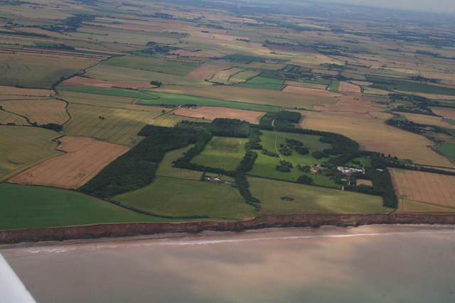
Grimston Park is a picturesque estate located in the heart of Yorkshire, England. Nestled between the rolling hills of the Yorkshire Downs and the vast expanse of moorland, it offers a stunning natural setting that attracts visitors from near and far.
Covering an extensive area, Grimston Park is renowned for its diverse landscapes. The Yorkshire Downs, with their undulating hills and lush greenery, provide a perfect backdrop for leisurely walks and horse riding. The views from the highest points are breathtaking, offering panoramic vistas for miles around.
In contrast, the adjacent moorland offers a wilder and more rugged experience. Visitors can explore the heather-clad expanses, which are home to a rich variety of flora and fauna, including unique bird species. The moorland is also crisscrossed by well-maintained trails, making it popular among hikers and nature enthusiasts.
Aside from its natural beauty, Grimston Park is steeped in history. The estate boasts an impressive manor house, which dates back several centuries. The stunning architecture and well-preserved interior provide a glimpse into the grandeur of the past. The estate also features beautifully landscaped gardens and a tranquil lake, creating a peaceful oasis for visitors to enjoy.
Grimston Park offers a range of amenities for visitors, including a charming tea room serving traditional Yorkshire treats, as well as picnic areas and designated camping spots. The estate is open year-round, and each season brings its own charm, from vibrant spring blooms to golden autumnal hues.
Overall, Grimston Park is a true gem in the Yorkshire countryside, offering a harmonious blend of stunning natural landscapes, rich history, and warm hospitality. It is a must-visit destination for those seeking tranquility and an escape from the hustle and bustle of daily life.
If you have any feedback on the listing, please let us know in the comments section below.
Grimston Park Images
Images are sourced within 2km of 53.795515/-0.05698614 or Grid Reference TA2834. Thanks to Geograph Open Source API. All images are credited.


Grimston Park is located at Grid Ref: TA2834 (Lat: 53.795515, Lng: -0.05698614)
Division: East Riding
Unitary Authority: East Riding of Yorkshire
Police Authority: Humberside
What 3 Words
///committee.primed.dynamics. Near Roos, East Yorkshire
Nearby Locations
Related Wikis

Grimston, East Riding of Yorkshire
Grimston is a hamlet in the civil parish of East Garton, in the East Riding of Yorkshire, England, in an area known as Holderness. It is situated approximately...
Hilston
Hilston is a village in the civil parish of Roos, in the East Riding of Yorkshire, England, near the North Sea coast in an area known as Holderness. It...

Garton
Garton (or Garton in Holderness) is a village in the East Riding of Yorkshire, England, in an area known as Holderness. It is situated approximately 7...

East Garton
East Garton is a civil parish in the East Riding of Yorkshire, England. It is situated 7 miles (11 km) to the north-west of Withernsea town centre and...

Owstwick
Owstwick is a hamlet in the civil parish of Roos, in the East Riding of Yorkshire, England, in an area known as Holderness. It is approximately 11 miles...
Fitling
Fitling is a hamlet in the civil parish of East Garton, in the East Riding of Yorkshire, England, in an area known as Holderness. It is situated approximately...
East Newton
East Newton is a hamlet in the civil parish of Aldbrough, in the East Riding of Yorkshire, England, in an area known as Holderness. It is situated approximately...

Tunstall, East Riding of Yorkshire
Tunstall is a village in the civil parish of Roos, in Holderness, in the East Riding of Yorkshire, England, close to the North Sea coast. It is situated...
Nearby Amenities
Located within 500m of 53.795515,-0.05698614Have you been to Grimston Park?
Leave your review of Grimston Park below (or comments, questions and feedback).