Mareham Moor

Downs, Moorland in Lincolnshire East Lindsey

England

Mareham Moor

Stubble field and St Helen's Wood
Stubble field and St Helen's Wood Credit: Jonathan Thacker

Mareham Moor is a small village located in Lincolnshire, England. It is situated on the edge of the Lincolnshire Wolds, an Area of Outstanding Natural Beauty known for its rolling hills and picturesque countryside. The village is surrounded by agricultural land, with fields of crops and grazing animals stretching out as far as the eye can see.

Mareham Moor itself is a quiet and peaceful village, with a small population and a close-knit community. The village is home to a few shops and amenities, including a local pub and a village hall. The landscape around Mareham Moor is characterized by open fields, hedgerows, and patches of woodland, creating a diverse and rich habitat for wildlife.

The area is popular with walkers and nature enthusiasts, who come to explore the nearby Downs and Moorland. The Lincolnshire Wolds offer stunning views and opportunities for hiking, cycling, and birdwatching. Mareham Moor is a charming and idyllic village, perfect for those looking to escape the hustle and bustle of city life and immerse themselves in the beauty of the English countryside.

If you have any feedback on the listing, please let us know in the comments section below.
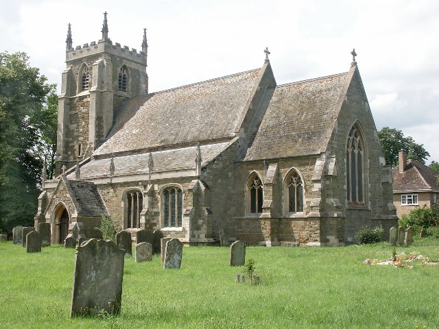
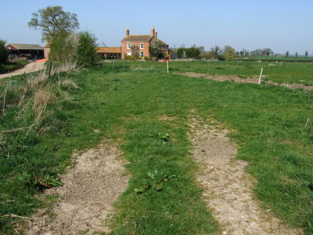
Mareham Moor Images

Images are sourced within 2km of 53.130543/-0.10821122 or Grid Reference TF2660. Thanks to Geograph Open Source API. All images are credited.

Stubble field and St Helen's Wood
Fen Lane A common feature of fenland roads is the tendency to be dead straight for a distance and then take a very sharp bend in order to avoid a drain or other water course. Here Fen Lan does just that as it approaches Mareham le Fen. At least the lack of hedgerows makes it easy to see oncoming traffic.
Fen Lane
A common feature of fenland roads is the tendency to be dead straight for a distance and then take a very sharp bend in order to avoid a drain or other water course. Here Fen Lan does just that as it approaches Mareham le Fen. At least the lack of hedgerows makes it easy to see oncoming traffic.
Direction Sign – Signpost on Horncastle Road in Mareham le Fen parish Located on a grass triangle in the centre of the junction of Horncastle Road and Fieldside in Mareham le Fen parish. 3 arms and no finial.

Milestone Society National ID: LI_TF2761
Direction Sign – Signpost on Horncastle Road in Mareham le Fen parish
Located on a grass triangle in the centre of the junction of Horncastle Road and Fieldside in Mareham le Fen parish. 3 arms and no finial. Milestone Society National ID: LI_TF2761
Muddy field near Enderby Hill Farm
Mumby's Bridge Road... ...crosses Mumby's Bridge to reach Mumby's Bridge Farm
Mumby's Bridge Road...
...crosses Mumby's Bridge to reach Mumby's Bridge Farm
Three Score Acre Looking north at the junction of Birkwood Lane and Fen Lane
Three Score Acre
Looking north at the junction of Birkwood Lane and Fen Lane
Country Road The road is near Birkwood Hall. I was 'buzzed' by a quad bike when parked here near the hall. The hall is to the left and behind me.
Country Road
The road is near Birkwood Hall. I was 'buzzed' by a quad bike when parked here near the hall. The hall is to the left and behind me.
Nursery Farm To the rear of the farm is St Helen's Wood.
Nursery Farm
To the rear of the farm is St Helen's Wood.
The junction of Mareham Beck with the Catchwater Drain Mareham Beck (right) brings water from the southern Wolds which is then taken by the Catchwater Drain to the main drains which feed into the River Witham. Here the scouring of the bed shows that the Mareham Beck is bringing a considerable amount of (remarkably clean) down off the Wolds after recent rain.
The junction of Mareham Beck with the Catchwater Drain
Mareham Beck (right) brings water from the southern Wolds which is then taken by the Catchwater Drain to the main drains which feed into the River Witham. Here the scouring of the bed shows that the Mareham Beck is bringing a considerable amount of (remarkably clean) down off the Wolds after recent rain.
Catchwater Drain
Catchwater Drain
Mareham Beck At the point where it joins the Catchwater Drain.
Mareham Beck
At the point where it joins the Catchwater Drain.
Mareham Beck Looking upstream.
Mareham Beck
Looking upstream.
Crop marks in field SW of Mareham le Fen: aerial 2018
Mareham Gate Farm
Mareham Gate Farm
Postbox at Mareham Gate
Roadway to Nursery Farm
Mareham Gate Farm View over a drain.
Mareham Gate Farm
View over a drain.
Station Road, Mareham Gate
Show me another place!

Mareham Moor is located at Grid Ref: TF2660 (Lat: 53.130543, Lng: -0.10821122)

Administrative County: Lincolnshire

District: East Lindsey

Police Authority: Lincolnshire

What 3 Words

///carefully.proper.monkey. Near Coningsby, Lincolnshire

Nearby Locations

Mareham Moor

Related Wikis

Mareham le Fen

Mareham le Fen (otherwise Mareham-le-Fen) is a village and civil parish about 6 miles (10 km) south from the town of Horncastle, Lincolnshire, England...

Haltham Coppice

Haltham Coppice is a small woodland in the parish of Tumby, Lincolnshire. == References ==

Haltham Wood

Haltham Wood is a woodland in the parish of Haltham in the East Lindsey district of Lincolnshire, England. == References ==

Wilksby

Wilksby is a hamlet in the civil parish of Wood Enderby, in the East Lindsey district of Lincolnshire. A former civil parish in itself, it was merged with...

Nearby Amenities

Located within 500m of 53.130543,-0.10821122
Source: OS_OpenData _StreetView
Lat/Long: 53.127252/-0.1076806
Source: OS_OpenData _StreetView
Lat/Long: 53.1315269/-0.1035499
Source: OS_OpenData _StreetView
Lat/Long: 53.1311025/-0.1040585
Material: wood
Power: pole
Lat/Long: 53.1267697/-0.1106067
Material: wood
Power: pole
Lat/Long: 53.1269647/-0.109247
Material: wood
Power: pole
Lat/Long: 53.1271613/-0.1078701
Material: wood
Power: pole
Lat/Long: 53.1273387/-0.1067368
Material: wood
Power: pole
Lat/Long: 53.1275105/-0.1055862
Material: wood
Power: pole
Lat/Long: 53.1276934/-0.1042713
Material: wood
Power: pole
Lat/Long: 53.1278844/-0.1029276
Power: pole
Source: Bing
Lat/Long: 53.132494/-0.1014924
Power: pole
Source: Bing
Lat/Long: 53.1329504/-0.1051222
Power: pole
Source: Bing
Lat/Long: 53.1331599/-0.104403
Power: pole
Source: Bing
Lat/Long: 53.1334525/-0.1033681
Mareham Moor
Place: locality
Source: Bing
Lat/Long: 53.1297181/-0.1088206
Fixme: Name of farm?
Place: farm
Source: Bing
Lat/Long: 53.1322822/-0.1043433
Primrose Cottage
Place: isolated_dwelling
Source: Bing
Lat/Long: 53.1332283/-0.1056622
The data included in this document is from www.openstreetmap.org. The data is made available under ODbL.

Have you been to Mareham Moor?

Leave your review of Mareham Moor below (or comments, questions and feedback).