Benniworth Moor

Downs, Moorland in Lincolnshire East Lindsey

England

Benniworth Moor

Benniworth: aerial 2022
Benniworth: aerial 2022 Credit: Chris

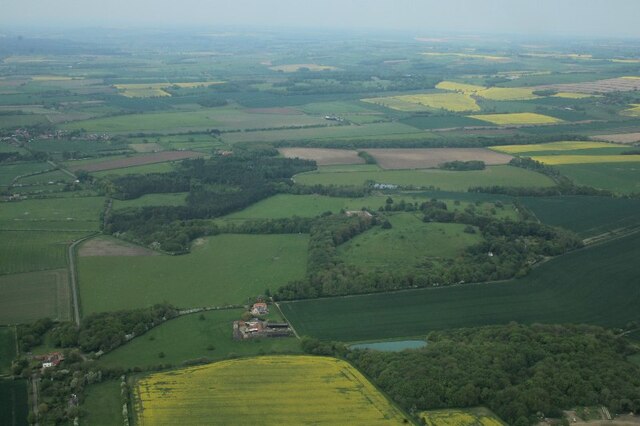
Benniworth Moor is a picturesque and tranquil area located in the county of Lincolnshire, England. Situated near the village of Benniworth, it covers a vast expanse of downs and moorland, offering visitors a unique and unspoiled natural landscape to explore.

The moorland of Benniworth Moor is characterized by its rolling hills, heather-covered terrain, and scattered patches of woodland. It is home to a rich variety of flora and fauna, including several rare and protected species. The moorland's diverse ecosystem provides a haven for wildlife, with sightings of birds such as the golden plover and curlew being common.

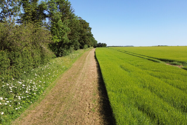
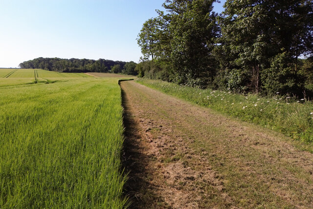
Visitors to Benniworth Moor can enjoy a range of outdoor activities amidst its stunning surroundings. Walking and hiking trails crisscross the moor, allowing visitors to explore its hidden corners and take in the breathtaking views. The area is also popular among nature enthusiasts, who can indulge in birdwatching, wildlife photography, and plant identification.

Benniworth Moor offers a peaceful and serene environment, providing a welcome escape from the hustle and bustle of modern life. Its remote location ensures a sense of tranquility and solitude, allowing visitors to connect with nature and relax in its serene ambiance.

Overall, Benniworth Moor is a hidden gem in Lincolnshire, offering a unique and captivating experience for those seeking natural beauty, wildlife encounters, and outdoor activities.

If you have any feedback on the listing, please let us know in the comments section below.

Benniworth Moor Images

Images are sourced within 2km of 53.308165/-0.20550995 or Grid Reference TF1980. Thanks to Geograph Open Source API. All images are credited.

Benniworth: aerial 2022
Fields near Low Farm, Benniworth: aerial 2022
Benniworth, south: aerial 2022
Stable block at site of Panton Hall: aerial 2022 (1) It dates from 1777 and was probably built by William Legg. It underwent alterations in the 20th century. 

See: <span class="nowrap"><a title="https://www.heritagegateway.org.uk/Gateway/Results_Single.aspx?uid=MLI93551&resourceID=1006" rel="nofollow ugc noopener" href="https://www.heritagegateway.org.uk/Gateway/Results_Single.aspx?uid=MLI93551&resourceID=1006">Link</a><img style="margin-left:2px;" alt="External link" title="External link - shift click to open in new window" src="https://s1.geograph.org.uk/img/external.png" width="10" height="10"/></span>
Stable block at site of Panton Hall: aerial 2022 (1)
It dates from 1777 and was probably built by William Legg. It underwent alterations in the 20th century. See: LinkExternal link
Stable block at site of Panton Hall: aerial 2022 (2) It dates from 1777 and was probably built by William Legg. It underwent alterations in the 20th century. 

See: <span class="nowrap"><a title="https://www.heritagegateway.org.uk/Gateway/Results_Single.aspx?uid=MLI93551&resourceID=1006" rel="nofollow ugc noopener" href="https://www.heritagegateway.org.uk/Gateway/Results_Single.aspx?uid=MLI93551&resourceID=1006">Link</a><img style="margin-left:2px;" alt="External link" title="External link - shift click to open in new window" src="https://s1.geograph.org.uk/img/external.png" width="10" height="10"/></span>
Stable block at site of Panton Hall: aerial 2022 (2)
It dates from 1777 and was probably built by William Legg. It underwent alterations in the 20th century. See: LinkExternal link
Stable block at site of Panton Hall: aerial 2022 (3) It dates from 1777 and was probably built by William Legg. It underwent alterations in the 20th century. 

See: <span class="nowrap"><a title="https://www.heritagegateway.org.uk/Gateway/Results_Single.aspx?uid=MLI93551&resourceID=1006" rel="nofollow ugc noopener" href="https://www.heritagegateway.org.uk/Gateway/Results_Single.aspx?uid=MLI93551&resourceID=1006">Link</a><img style="margin-left:2px;" alt="External link" title="External link - shift click to open in new window" src="https://s1.geograph.org.uk/img/external.png" width="10" height="10"/></span>
Stable block at site of Panton Hall: aerial 2022 (3)
It dates from 1777 and was probably built by William Legg. It underwent alterations in the 20th century. See: LinkExternal link
Panton: aerial 2023 (1)  Park and stable block, which is a listed building dating from 1777. 

Panton Hall itself was demolished in 1964.

See <a href="https://www.geograph.org.uk/photo/3595000">TF1880 : Stable Block at site of Panton Hall: aerial</a>, <span class="nowrap"><a title="http://www.britishlistedbuildings.co.uk/en-195409-stable-block-at-site-of-panton-hall-east#.VZEDdRurQsY" rel="nofollow ugc noopener" href="http://www.britishlistedbuildings.co.uk/en-195409-stable-block-at-site-of-panton-hall-east#.VZEDdRurQsY">Link</a><img style="margin-left:2px;" alt="External link" title="External link - shift click to open in new window" src="https://s1.geograph.org.uk/img/external.png" width="10" height="10"/></span>.
Panton: aerial 2023 (1)
Park and stable block, which is a listed building dating from 1777. Panton Hall itself was demolished in 1964. See TF1880 : Stable Block at site of Panton Hall: aerial, LinkExternal link.
Panton: aerial 2023 (2) Park and stable block, which is a listed building dating from 1777. 

Panton Hall itself was demolished in 1964.

See <a href="https://www.geograph.org.uk/photo/3595000">TF1880 : Stable Block at site of Panton Hall: aerial</a>, <span class="nowrap"><a title="http://www.britishlistedbuildings.co.uk/en-195409-stable-block-at-site-of-panton-hall-east#.VZEDdRurQsY" rel="nofollow ugc noopener" href="http://www.britishlistedbuildings.co.uk/en-195409-stable-block-at-site-of-panton-hall-east#.VZEDdRurQsY">Link</a><img style="margin-left:2px;" alt="External link" title="External link - shift click to open in new window" src="https://s1.geograph.org.uk/img/external.png" width="10" height="10"/></span>.
Panton: aerial 2023 (2)
Park and stable block, which is a listed building dating from 1777. Panton Hall itself was demolished in 1964. See TF1880 : Stable Block at site of Panton Hall: aerial, LinkExternal link.
Panton: aerial 2023 (3) Park, walled garden and stable block. The latter is a listed building dating from 1777. 

Panton Hall itself was demolished in 1964.

See <a href="https://www.geograph.org.uk/photo/3595000">TF1880 : Stable Block at site of Panton Hall: aerial</a>, <span class="nowrap"><a title="http://www.britishlistedbuildings.co.uk/en-195409-stable-block-at-site-of-panton-hall-east#.VZEDdRurQsY" rel="nofollow ugc noopener" href="http://www.britishlistedbuildings.co.uk/en-195409-stable-block-at-site-of-panton-hall-east#.VZEDdRurQsY">Link</a><img style="margin-left:2px;" alt="External link" title="External link - shift click to open in new window" src="https://s1.geograph.org.uk/img/external.png" width="10" height="10"/></span>.
Panton: aerial 2023 (3)
Park, walled garden and stable block. The latter is a listed building dating from 1777. Panton Hall itself was demolished in 1964. See TF1880 : Stable Block at site of Panton Hall: aerial, LinkExternal link.
Track to Panton Stables
Panton Park and Stables, and Warren Farm: aerial 2023
Panton Park and Stables: aerial 2023
Track along Whitepits Plantation A similar view to <a href="https://www.geograph.org.uk/photo/812585">TF1881 : Field edge</a>
Track along Whitepits Plantation
A similar view to TF1881 : Field edge
Track along Whitepits Plantation Looking south towards the road.
The opposite way to <a href="https://www.geograph.org.uk/photo/7513268">TF1881 : Track along Whitepits Plantation</a>
Track along Whitepits Plantation
Looking south towards the road. The opposite way to TF1881 : Track along Whitepits Plantation
St Julian's church, Benniworth The unusual dedication could relate to several Martyrs of that name.
St Julian's church, Benniworth
The unusual dedication could relate to several Martyrs of that name.
Interior, St Julian's church, Benniworth A modest interior.
Interior, St Julian's church, Benniworth
A modest interior.
Organ, St Julian's church, Benniworth 2 Manual and Pedals with 8 stops by W. E. Richardson & Sons, 1896.
Quoted as "nicely voiced".
Organ, St Julian's church, Benniworth
2 Manual and Pedals with 8 stops by W. E. Richardson & Sons, 1896. Quoted as "nicely voiced".
Font, St Julian's church, Benniworth Grade II listed.

A cruciform church dating back to the mid-twelfth century, but was almost entirely rebuilt in 1875 by Fowler.

The church is built in greenstone with ashlar dressings and slate roofs.
There is a west tower, nave with small north and south transepts, chancel and north vestry.

The tower is of three stages and has elements of the old twelfth century fabric, but was heavily restored in the nineteenth century. A pyramid roof was added.
The west door similarly dates from the twelfth century but was heavily restored, Pevsner stating it is probably 90% Fowler.
The north and south transepts and chancel, originally from the eighteenth century were also rebuilt in 1875.
The transepts have two Bay arcades.
There is a pointed chancel arch from the mid-thirteenth century with a fifteenth century screen which was restored in 1905.
The font dates from the twelfth century, being round with intersecting arcading, heavily restored in the 19th century.

There is a modest organ by Richardson and sons in the north transept.

The remains of fourteenth century cross consisting of base and shaft stand in the churchyard.
Font, St Julian's church, Benniworth
Grade II listed. A cruciform church dating back to the mid-twelfth century, but was almost entirely rebuilt in 1875 by Fowler. The church is built in greenstone with ashlar dressings and slate roofs. There is a west tower, nave with small north and south transepts, chancel and north vestry. The tower is of three stages and has elements of the old twelfth century fabric, but was heavily restored in the nineteenth century. A pyramid roof was added. The west door similarly dates from the twelfth century but was heavily restored, Pevsner stating it is probably 90% Fowler. The north and south transepts and chancel, originally from the eighteenth century were also rebuilt in 1875. The transepts have two Bay arcades. There is a pointed chancel arch from the mid-thirteenth century with a fifteenth century screen which was restored in 1905. The font dates from the twelfth century, being round with intersecting arcading, heavily restored in the 19th century. There is a modest organ by Richardson and sons in the north transept. The remains of fourteenth century cross consisting of base and shaft stand in the churchyard.
Show me another place!

Benniworth Moor is located at Grid Ref: TF1980 (Lat: 53.308165, Lng: -0.20550995)

Administrative County: Lincolnshire

District: East Lindsey

Police Authority: Lincolnshire

What 3 Words

///medium.fans.influence. Near Wragby, Lincolnshire

Related Wikis

Benniworth

Benniworth is a village and civil parish in the East Lindsey district of Lincolnshire, England. The village is situated just west of the B1225 road, and...

Sotby

Sotby is a village and civil parish in the East Lindsey district of Lincolnshire, England. It is situated 15 miles (24 km) north-east from the city and...

South Willingham and Hainton railway station

South Willingham and Hainton railway station was a railway station that served the village of South Willingham, Lincolnshire, England between 1874 and...

East Barkwith railway station

East Barkwith railway station was a railway station that served the village of East Barkwith, Lincolnshire, England between 1874 and 1958, on the Louth...

Panton, Lincolnshire

Panton is a village in the civil parish of East Barkwith, in the East Lindsey of district, Lincolnshire, England. It is situated approximately 13 miles...

South Willingham

South Willingham is a village and civil parish in the East Lindsey district of Lincolnshire, England, and partly within the Lincolnshire Wolds Area of...

East Barkwith

East Barkwith is a village and civil parish in the East Lindsey district of Lincolnshire, England. It is situated on the A157, and approximately 13 miles...

Market Stainton

Market Stainton is a village and civil parish in the East Lindsey district of Lincolnshire, England. It is situated approximately 7 miles (11 km) north...

Nearby Amenities

Located within 500m of 53.308165,-0.20550995
Benniworth Moor Farm
Place: farm
Source: Bing
Lat/Long: 53.3080469/-0.2034336
Benniworth Moor
Place: locality
Source: Bing
Lat/Long: 53.3048222/-0.2020391
Note: End of Public Highway
Lat/Long: 53.3070043/-0.2012998
The data included in this document is from www.openstreetmap.org. The data is made available under ODbL.

Have you been to Benniworth Moor?

Leave your review of Benniworth Moor below (or comments, questions and feedback).