Bottom Park

Downs, Moorland in Leicestershire Melton

England

Bottom Park

Path and Stile near Burton Lazars Trig Point
Path and Stile near Burton Lazars Trig Point Credit: thejackrustles

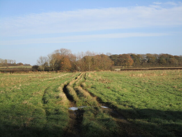
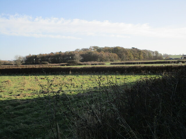
Bottom Park is a picturesque rural area located in Leicestershire, England. Situated in the heart of the county, it is known for its beautiful downs and vast moorland. Covering a sprawling area of approximately 500 acres, this natural wonderland offers visitors a tranquil escape from the hustle and bustle of city life.

The park is characterized by its gently rolling hills and open grassland, providing breathtaking panoramic views of the surrounding countryside. Its diverse ecosystem supports a wide range of flora and fauna, making it a haven for nature enthusiasts. Visitors can spot a variety of wildlife, including rabbits, foxes, and various species of birds.

Bottom Park is also home to a network of well-maintained footpaths and trails, making it an ideal destination for walkers, hikers, and cyclists. These paths meander through the park, allowing visitors to explore its different terrains and discover hidden gems along the way.

In addition to its natural beauty, Bottom Park offers various recreational facilities. There is a designated picnic area, complete with benches and tables, where visitors can enjoy a leisurely lunch amidst the serene surroundings. The park also houses a children's playground, providing entertainment for younger visitors.

Overall, Bottom Park in Leicestershire is a haven for those seeking a peaceful retreat in nature. With its stunning downs, expansive moorland, and abundant wildlife, it offers a truly enchanting experience for all who visit.

If you have any feedback on the listing, please let us know in the comments section below.

Bottom Park Images

Images are sourced within 2km of 52.739659/-0.86489209 or Grid Reference SK7616. Thanks to Geograph Open Source API. All images are credited.

Path and Stile near Burton Lazars Trig Point
Burton Lazars Trig Point Flush Bracket S4660
Footpath Sign - Burton Lazars
The churchyard, Burton Lazars The churchyard has a fine collection of Swithland slate headstones.
The churchyard, Burton Lazars
The churchyard has a fine collection of Swithland slate headstones.
Melton Road north of Burton Lazars There is a just a short gap between Burton Lazars and the edge of Melton Mowbray.
Melton Road north of Burton Lazars
There is a just a short gap between Burton Lazars and the edge of Melton Mowbray.
The Jubilee Way on the edge of Melton Mowbray
Muddy track through woodland OS shows this as a road used as a public footpath but it does not appear on the Leicestershire County Council interactive footpath map.
Muddy track through woodland
OS shows this as a road used as a public footpath but it does not appear on the Leicestershire County Council interactive footpath map.
Track across a grass field OS shows this as a road used as a public footpath but it does not appear on the Leicestershire County Council interactive footpath map.
Track across a grass field
OS shows this as a road used as a public footpath but it does not appear on the Leicestershire County Council interactive footpath map.
Flooded track OS shows this as a road used as a public footpath but it does not appear on the Leicestershire County Council interactive footpath map.
Flooded track
OS shows this as a road used as a public footpath but it does not appear on the Leicestershire County Council interactive footpath map.
Ice covered pool A thin layer of ice covers this pool.
Ice covered pool
A thin layer of ice covers this pool.
Track alongside a sprayed field OS shows this as a road used as a public footpath but it does not appear on the Leicestershire County Council interactive footpath map.
Track alongside a sprayed field
OS shows this as a road used as a public footpath but it does not appear on the Leicestershire County Council interactive footpath map.
Lone tree and sprayed field Burton Lazars in the distance.
Lone tree and sprayed field
Burton Lazars in the distance.
Ellaby's Spinney
Ellaby's Spinney
Sprayed field Burton Lazars in the distance.
Sprayed field
Burton Lazars in the distance.
Sprayed field and small area of woodland
Monument to William Squires, Burton Lazars William Squires died in 1781 and half his estate was left to erect this monument <span class="nowrap"><a title="https://historicengland.org.uk/listing/the-list/list-entry/1307784" rel="nofollow ugc noopener" href="https://historicengland.org.uk/listing/the-list/list-entry/1307784">Link</a><img style="margin-left:2px;" alt="External link" title="External link - shift click to open in new window" src="https://s1.geograph.org.uk/img/external.png" width="10" height="10"/></span>
Monument to William Squires, Burton Lazars
William Squires died in 1781 and half his estate was left to erect this monument LinkExternal link
Setting up the Christmas tree, St. James' church, Burton Lazars The chancel of St. James' church was rebuilt in 1850 <span class="nowrap"><a title="https://historicengland.org.uk/listing/the-list/list-entry/1360836" rel="nofollow ugc noopener" href="https://historicengland.org.uk/listing/the-list/list-entry/1360836">Link</a><img style="margin-left:2px;" alt="External link" title="External link - shift click to open in new window" src="https://s1.geograph.org.uk/img/external.png" width="10" height="10"/></span>
Setting up the Christmas tree, St. James' church, Burton Lazars
The chancel of St. James' church was rebuilt in 1850 LinkExternal link
St. James' church, Burton Lazars Medieval church with a chancel of 1850 <span class="nowrap"><a title="https://historicengland.org.uk/listing/the-list/list-entry/1360836" rel="nofollow ugc noopener" href="https://historicengland.org.uk/listing/the-list/list-entry/1360836">Link</a><img style="margin-left:2px;" alt="External link" title="External link - shift click to open in new window" src="https://s1.geograph.org.uk/img/external.png" width="10" height="10"/></span>
St. James' church, Burton Lazars
Medieval church with a chancel of 1850 LinkExternal link
Show me another place!

Bottom Park is located at Grid Ref: SK7616 (Lat: 52.739659, Lng: -0.86489209)

Administrative County: Leicestershire

District: Melton

Police Authority: Leicestershire

What 3 Words

///swimmer.browser.pats. Near Melton Mowbray, Leicestershire

Related Wikis

Burton Lazars

Burton Lazars is a village and former civil parish, now in the parish of Burton and Dalby, in the Melton district, in the county of Leicestershire, England...

Burton and Dalby

Burton and Dalby is a civil parish in the Melton district of Leicestershire, England, to the south of Melton Mowbray. It covers the villages of Burton...

King Edward VII School, Melton Mowbray

King Edward VII School (KE7) was an LEA maintained 11-19 comprehensive secondary school in Melton Mowbray, Leicestershire in England which closed in 2011...

Melton Town F.C.

Melton Town Football Club is a football club based in Melton Mowbray, Leicestershire, England. They are currently members of the United Counties League...

Nearby Amenities

Located within 500m of 52.739659,-0.86489209
Bus Stop
Melton Road
Alt Name: Burton Lazars - Lime Street
Bus: yes
Naptan AltCommonName: Burton Lazars - Lime Street
Naptan AtcoCode: 260000503
Naptan Bearing: S
Naptan CommonName: Melton Road
Naptan Indicator: outside
Naptan Landmark: 27 Hillside House
Naptan NaptanCode: leidmwdm
Naptan Notes: Hourly - County
Naptan Street: Melton Road
Naptan Verified: no
Public Transport: platform
Shelter: no
Source: naptan_import
Lat/Long: 52.7432985/-0.8630895
Turning Circle
Lat/Long: 52.7391986/-0.8674887
Turning Circle
Lat/Long: 52.7386634/-0.8681221
The data included in this document is from www.openstreetmap.org. The data is made available under ODbL.

Have you been to Bottom Park?

Leave your review of Bottom Park below (or comments, questions and feedback).