Hawes Side

Settlement in Lancashire

England

Hawes Side

Pumping station on Blackpool seafront A sewage pumping station on Blackpool's seafront.
Pumping station on Blackpool seafront Credit: Malc McDonald

Hawes Side is a residential area located in the town of Blackpool, Lancashire, in the northwest of England. Situated approximately 3 miles south of Blackpool town center, Hawes Side is a well-established community that offers a range of amenities and easy access to nearby attractions.

The area is primarily comprised of residential properties, including a mix of semi-detached houses, bungalows, and some flats. The housing stock in Hawes Side is generally well-maintained and appeals to families, professionals, and retirees alike. The streets are lined with neatly kept gardens, and there are several green spaces and parks dotted around the neighborhood, providing residents with opportunities for recreation and leisure activities.

Hawes Side benefits from excellent transport links, with regular bus services connecting the area to Blackpool town center and surrounding suburbs. The nearby M55 motorway also offers convenient access to the wider region, including major cities such as Preston and Manchester.

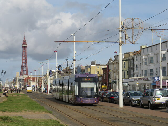
Local amenities in Hawes Side include a variety of shops, convenience stores, and small businesses. There are also several schools in the area, catering to children of all ages. For leisure and entertainment, residents can visit nearby attractions such as Blackpool Pleasure Beach, the iconic Blackpool Tower, and the sandy beaches of the Promenade, all just a short distance away.

Overall, Hawes Side offers a peaceful and family-friendly environment, with a range of amenities and attractions within easy reach. Its location, close to the vibrant town of Blackpool, makes it an attractive place to live for those seeking a balance between residential tranquility and urban convenience.

If you have any feedback on the listing, please let us know in the comments section below.

Hawes Side Images

Images are sourced within 2km of 53.798317/-3.030856 or Grid Reference SD3234. Thanks to Geograph Open Source API. All images are credited.

Pumping station on Blackpool seafront A sewage pumping station on Blackpool's seafront.
Pumping station on Blackpool seafront
A sewage pumping station on Blackpool's seafront.
Tram on Blackpool seafront A tramway runs the full length of Blackpool's seafront, from Starr Gate to Bispham, then continues to Cleveleys and Fleetwood.  It forms an integral part of Blackpool's public transport system.  Blackpool Tower stands tall in the background to this image.
Tram on Blackpool seafront
A tramway runs the full length of Blackpool's seafront, from Starr Gate to Bispham, then continues to Cleveleys and Fleetwood. It forms an integral part of Blackpool's public transport system. Blackpool Tower stands tall in the background to this image.
Blackpool seafront The seafront at Blackpool, with the tide coming in.  Blackpool's expanse of sandy beach has become submerged by the sea.
Blackpool seafront
The seafront at Blackpool, with the tide coming in. Blackpool's expanse of sandy beach has become submerged by the sea.
Tram on Blackpool seafront Blackpool's tramway runs the full length of the town's seafront.  In this image, a tram heads away from the camera towards Blackpool Tower.
Tram on Blackpool seafront
Blackpool's tramway runs the full length of the town's seafront. In this image, a tram heads away from the camera towards Blackpool Tower.
Blackpool promenade Blackpool promenade.
Blackpool promenade
Blackpool promenade.
South Pier, Blackpool South Pier (originally known as Victoria Pier) is one of three piers at Blackpool. Located on the South Shore, the pier contains a number of amusement and adrenalin rides. It opened in 1893. At 149 m (488 ft 10 in) long, it is the shortest of the three piers (<span class="nowrap"><a title="http://en.wikipedia.org/wiki/South_Pier,_Blackpool" rel="nofollow ugc noopener" href="http://en.wikipedia.org/wiki/South_Pier,_Blackpool">Link</a><img style="margin-left:2px;" alt="External link" title="External link - shift click to open in new window" src="https://s1.geograph.org.uk/img/external.png" width="10" height="10"/></span> Wikipedia).
South Pier, Blackpool
South Pier (originally known as Victoria Pier) is one of three piers at Blackpool. Located on the South Shore, the pier contains a number of amusement and adrenalin rides. It opened in 1893. At 149 m (488 ft 10 in) long, it is the shortest of the three piers (LinkExternal link Wikipedia).
Rides at Blackpool Pleasure Beach There may be more than one rollercoaster ride intertwined here.
Rides at Blackpool Pleasure Beach
There may be more than one rollercoaster ride intertwined here.
Ripley's Believe It or Not, Blackpool A long established feature of the town, though apparently it was relocated to the Pleasure Beach from its original home in the town centre.
Ripley's Believe It or Not, Blackpool
A long established feature of the town, though apparently it was relocated to the Pleasure Beach from its original home in the town centre.
Entrance building, Blackpool Pleasure Beach Viewed from the nearby tram stop.
Entrance building, Blackpool Pleasure Beach
Viewed from the nearby tram stop.
Blackpool Promenade Blackpool Promenade is home to the annual Blackpool Illuminations, a free light festival that has been running since 1879
Blackpool Promenade
Blackpool Promenade is home to the annual Blackpool Illuminations, a free light festival that has been running since 1879
The Pleasure Beach seen from The Promenade, Blackpool
High Tide Organ, Blackpool Designed by Liam Curtin and John Gooding (2002).
High Tide Organ, Blackpool
Designed by Liam Curtin and John Gooding (2002).
High Tide Organ, Blackpool Designed by Liam Curtin and John Gooding (2002).
High Tide Organ, Blackpool
Designed by Liam Curtin and John Gooding (2002).
Shelter, Promenade, Blackpool The High Tide Organ is in the background on the left.
Shelter, Promenade, Blackpool
The High Tide Organ is in the background on the left.
Under the South Pier, Blackpool South Pier (originally known as Victoria Pier) is one of three piers at Blackpool. Located on the South Shore, the pier contains a number of amusement and adrenalin rides. It opened in 1893. At 149 m (488 ft 10 in) long, it is the shortest of the three piers (<span class="nowrap"><a title="http://en.wikipedia.org/wiki/South_Pier,_Blackpool" rel="nofollow ugc noopener" href="http://en.wikipedia.org/wiki/South_Pier,_Blackpool">Link</a><img style="margin-left:2px;" alt="External link" title="External link - shift click to open in new window" src="https://s1.geograph.org.uk/img/external.png" width="10" height="10"/></span> Wikipedia).
Under the South Pier, Blackpool
South Pier (originally known as Victoria Pier) is one of three piers at Blackpool. Located on the South Shore, the pier contains a number of amusement and adrenalin rides. It opened in 1893. At 149 m (488 ft 10 in) long, it is the shortest of the three piers (LinkExternal link Wikipedia).
The South Pier, Blackpool South Pier (originally known as Victoria Pier) is one of three piers at Blackpool. Located on the South Shore, the pier contains a number of amusement and adrenalin rides. It opened in 1893. At 149 m (488 ft 10 in) long, it is the shortest of the three piers (<span class="nowrap"><a title="http://en.wikipedia.org/wiki/South_Pier,_Blackpool" rel="nofollow ugc noopener" href="http://en.wikipedia.org/wiki/South_Pier,_Blackpool">Link</a><img style="margin-left:2px;" alt="External link" title="External link - shift click to open in new window" src="https://s1.geograph.org.uk/img/external.png" width="10" height="10"/></span> Wikipedia).
The South Pier, Blackpool
South Pier (originally known as Victoria Pier) is one of three piers at Blackpool. Located on the South Shore, the pier contains a number of amusement and adrenalin rides. It opened in 1893. At 149 m (488 ft 10 in) long, it is the shortest of the three piers (LinkExternal link Wikipedia).
Entrance to the South Pier, Blackpool South Pier (originally known as Victoria Pier) is one of three piers at Blackpool. Located on the South Shore, the pier contains a number of amusement and adrenalin rides. It opened in 1893. At 149 m (488 ft 10 in) long, it is the shortest of the three piers (<span class="nowrap"><a title="http://en.wikipedia.org/wiki/South_Pier,_Blackpool" rel="nofollow ugc noopener" href="http://en.wikipedia.org/wiki/South_Pier,_Blackpool">Link</a><img style="margin-left:2px;" alt="External link" title="External link - shift click to open in new window" src="https://s1.geograph.org.uk/img/external.png" width="10" height="10"/></span> Wikipedia).
Entrance to the South Pier, Blackpool
South Pier (originally known as Victoria Pier) is one of three piers at Blackpool. Located on the South Shore, the pier contains a number of amusement and adrenalin rides. It opened in 1893. At 149 m (488 ft 10 in) long, it is the shortest of the three piers (LinkExternal link Wikipedia).
Show me another place!

Hawes Side is located at Grid Ref: SD3234 (Lat: 53.798317, Lng: -3.030856)

Unitary Authority: Blackpool

Police Authority: Lancashire

What 3 Words

///look.ready.crunch. Near Great Marton, Lancashire

Related Wikis

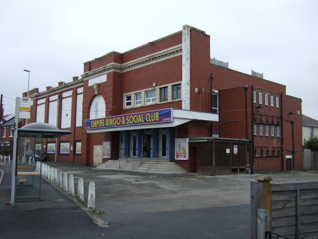
Empire Cinema, Blackpool

The Empire Cinema was a 1920s structure in Blackpool, Lancashire, in England, United Kingdom. It was built as a cinema and was used as such until 1959...

Marton, Blackpool

Marton is a historic village on the coastal plain of the Fylde in the Borough of Blackpool in Lancashire, England, most of which is now forms a part of...
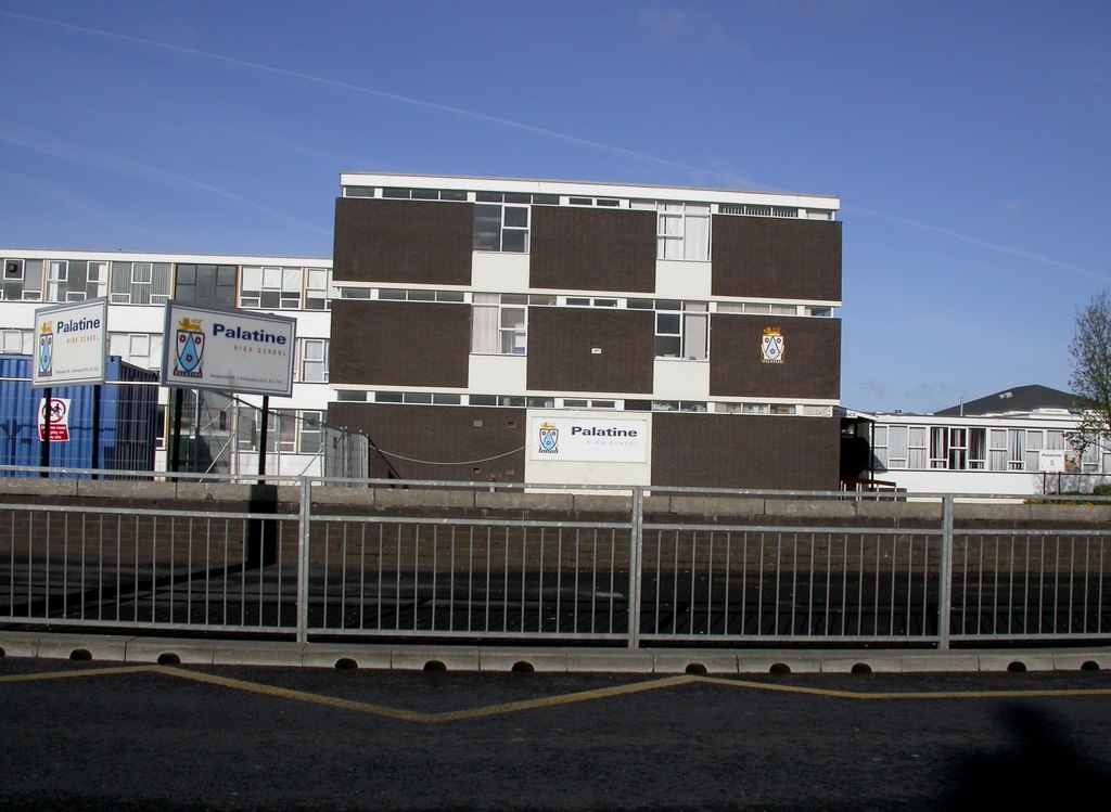
South Shore Academy

South Shore Academy (formerly Palatine Community Sports College) is a school in South Shore, Blackpool, Lancashire. A National Lottery Grant enabled the...

Noor-A-Madina Mosque

Noor-A-Madina Ahle Sunnat Mosque is a Sunni Islam mosque in Blackpool, Lancashire, England. == Facilities == Currently, there are two 200-person capacity...

Nearby Amenities

Located within 500m of 53.798317,-3.030856
Crossing
Crossing: zebra
Crossing Ref: zebra
Lat/Long: 53.7970279/-3.0237063
Crossing
Crossing: zebra
Crossing Ref: zebra
Lat/Long: 53.7992027/-3.0278794
Traffic Signals
Traffic Signals: signal
Traffic Signals Direction: backward
Lat/Long: 53.8001043/-3.0336268
Turning Circle
Lat/Long: 53.8008356/-3.0313031
Turning Circle
Lat/Long: 53.8003398/-3.033261
Traffic Signals
Traffic Signals: signal
Traffic Signals Direction: forward
Lat/Long: 53.8004633/-3.034011
Mini Roundabout
Direction: clockwise
Lat/Long: 53.7975399/-3.0253875
Mini Roundabout
Direction: clockwise
Lat/Long: 53.796465/-3.0299846
Post Office
Daggers Hall Lane Post Office
Addr City: Blackpool
Addr Housenumber: 157
Addr Postcode: FY4 4NG
Addr Street: Vicarage Lane
Brand: Post Office
Brand Wikidata: Q1783168
Ref Pol Id: 4101
Website: https://www.postoffice.co.uk/branch-finder/1654055/daggers-hall-lane
Lat/Long: 53.7973138/-3.025271
Mini Roundabout
Direction: clockwise
Lat/Long: 53.7967772/-3.0301883
Place Of Worship
Salvation Army
Addr City: Blackpool
Addr Country: GB
Addr Postcode: FY4 3BB
Addr Street: Dorset Street
Denomination: salvation_army
Email: blackpool.south@salvationarmy.org.uk
Fhrs Id: 510546
Phone: 01253 626114
Religion: christian
Website: https://www.salvationarmy.org.uk/blackpool-south
Lat/Long: 53.798405/-3.0381778
Turning Circle
Lat/Long: 53.7966739/-3.0346472
Turning Circle
Lat/Long: 53.7965091/-3.0356352
Turning Circle
Lat/Long: 53.7963743/-3.0266217
Mini Roundabout
Direction: clockwise
Lat/Long: 53.7986154/-3.0271353
Post Box
Collection Times: Mo-Fr 16:45; Sa 11:00; Su off
Operator: Royal Mail
Operator Wikidata: Q638098
Post Box Type: pillar
Ref: FY1 243
Royal Cypher: GVIR
Royal Cypher Wikidata: Q33102169
Lat/Long: 53.8019678/-3.0311154
Post Box
Brand: Royal Mail
Brand Wikidata: Q638098
Collection Times: Mo-Fr 09:00; Sa 07:00; Su off
Drive Through: no
Operator: Royal Mail
Operator Wikidata: Q638098
Post Box Type: pillar
Ref: FY4 226D
Royal Cypher: EIIR
Royal Cypher Wikidata: Q33102113
Lat/Long: 53.7968856/-3.0370266
One Stop
Addr City: Blackpool
Addr Housenumber: 77-81
Addr Postcode: FY4 4AX
Addr Street: Daggers Hall Lane
Brand: One Stop
Brand Wikidata: Q65954217
Contact Website: https://www.onestop.co.uk/store?store=17e6169f-1972-4fe6-b773-fdd3156696ad
Fhrs Id: 1544537
Shop: convenience
Lat/Long: 53.7964861/-3.0294533
Fast Food
Spen Pizza & Kebabs
Addr City: Blackpool
Addr Postcode: FY4 4AS
Cuisine: kebab
Fhrs Id: 911710
Lat/Long: 53.7999047/-3.0335592
Post Box
Brand: Royal Mail
Brand Wikidata: Q638098
Collection Times: Mo-Fr 09:00; Sa 07:00; Su off
Drive Through: no
Operator: Royal Mail
Operator Wikidata: Q638098
Post Box Type: pillar
Ref: FY4 242D
Royal Cypher: EIIR
Royal Cypher Wikidata: Q33102113
Lat/Long: 53.7970306/-3.0303846
Post Box
Brand: Royal Mail
Brand Wikidata: Q638098
Collection Times: Mo-Fr 17:00; Sa 12:45; Su off
Drive Through: no
Operator: Royal Mail
Operator Wikidata: Q638098
Post Box Type: pillar
Ref: FY4 308
Royal Cypher: EIIR
Royal Cypher Wikidata: Q33102113
Lat/Long: 53.7998635/-3.0291074
Post Box
Collection Times: Mo-Fr 17:30; Sa 11:30; Su off
Operator: Royal Mail
Operator Wikidata: Q638098
Post Box Type: pillar
Ref: FY4 129
Royal Cypher: GR
Royal Cypher Wikidata: Q33102273
Lat/Long: 53.797374/-3.0250798
Pharmacy
Whitworth Chemists Ltd
Addr City: Blackpool
Addr Postcode: FY4 3AG
Addr Street: Waterloo Road
Dispensing: yes
Healthcare: pharmacy
Lat/Long: 53.8002613/-3.0361889
Post Box
Collection Times: Mo-Fr 09:00; Sa 07:00; Su off
Operator: Royal Mail
Operator Wikidata: Q638098
Post Box Type: lamp
Ref: FY4 283D
Royal Cypher: EIIR
Royal Cypher Wikidata: Q33102113
Lat/Long: 53.7961665/-3.0249014
Post Box
Brand: Royal Mail
Brand Wikidata: Q638098
Collection Times: Mo-Fr 16:45; Sa 11:45; Su off
Drive Through: no
Operator: Royal Mail
Operator Wikidata: Q638098
Post Box Type: pillar
Ref: FY4 56
Royal Cypher: EIIR
Royal Cypher Wikidata: Q33102113
Lat/Long: 53.7997448/-3.0333041
Fast Food
333
Addr City: Blackpool
Addr Postcode: FY4 3AF
Addr Street: Waterloo Road
Cuisine: chinese
Fhrs Id: 140342
Lat/Long: 53.8001372/-3.0372638
Fast Food
Mad About Pizza
Addr City: Blackpool
Addr Postcode: FY4 3AF
Addr Street: Waterloo Road
Cuisine: pizza
Fhrs Id: 140667
Lat/Long: 53.8001277/-3.0374221
Pricewise
Addr City: Blackpool
Addr Housenumber: 199
Addr Postcode: FY4 4AA
Addr Street: Hawes Side Lane
Fhrs Id: 141981
Shop: convenience
Lat/Long: 53.7949899/-3.029577
Fast Food
The Golden Fish
Addr City: Blackpool
Addr Housenumber: 171
Addr Postcode: FY4 4AA
Addr Street: Hawes Side Lane
Cuisine: fish_and_chips
Takeaway: yes
Lat/Long: 53.7962233/-3.0295489
Fast Food
Juan Hua Lodge
Addr City: Blackpool
Addr Housenumber: 72
Addr Postcode: FY4 4AS
Addr Street: Hawes Side Lane
Cuisine: chinese
Fhrs Id: 1514320
Lat/Long: 53.7983382/-3.0317047
The Cottage Bakery
Addr City: Blackpool
Addr Postcode: FY4 4AP
Fhrs Id: 141982
Shop: bakery
Lat/Long: 53.7993474/-3.0324879
Fast Food
Addr City: Blackpool
Addr Postcode: FY4 3DE
Cuisine: sandwich
Lat/Long: 53.7998939/-3.0337915
Fast Food
Lai Sing
Addr City: Blackpool
Addr Postcode: FY4 3DP
Cuisine: chinese
Fhrs Id: 141922
Lat/Long: 53.7969647/-3.0370504
Fast Food
Chutney Blue
Addr City: Blackpool
Addr Housenumber: 95-97
Addr Postcode: FY4 3EU
Addr Street: Marton Drive
Cuisine: indian
Fhrs Id: 141923
Takeaway: yes
Lat/Long: 53.7960696/-3.0372301
Asda
Addr City: Blackpool
Addr Postcode: FY4 4ES
Brand: Asda
Brand Wikidata: Q297410
Brand Wikipedia: en:Asda
Contact Website: https://storelocator.asda.com/north-west/blackpool/1-welbeck-avenue
Fhrs Id: 829126
Operator: Asda Stores Ltd
Shop: supermarket
Lat/Long: 53.7986232/-3.0253506
Fast Food
Greggs
Addr City: Blackpool
Addr Postcode: FY4 4ES
Brand: Greggs
Brand Wikidata: Q3403981
Brand Wikipedia: en:Greggs
Contact Website: https://www.greggs.co.uk/shop-finder?shop-code=1793
Cuisine: sandwich;bakery
Fhrs Id: 140556
Shop: bakery
Takeaway: yes
Lat/Long: 53.7987802/-3.0255546
Iceland
Addr City: Blackpool
Addr Postcode: FY4 4ES
Brand: Iceland
Brand Wikidata: Q721810
Contact Website: https://www.iceland.co.uk/store-finder/store?StoreID=374&StoreName=BLACKPOOL%20VIC%20LANE
Fhrs Id: 643472
Shop: frozen_food
Lat/Long: 53.7989345/-3.025721
Fast Food
Kung Food Panda
Addr City: Blackpool
Addr Postcode: FY4 4EL
Cuisine: chinese
Fhrs Id: 951135
Lat/Long: 53.7996503/-3.0285832
Fast Food
Curry Time
Addr City: Blackpool
Addr Postcode: FY4 4EL
Cuisine: indian
Fhrs Id: 140500
Takeaway: yes
Lat/Long: 53.7996155/-3.0285376
Farmhouse Pantry
Addr City: Blackpool
Addr Postcode: FY4 4EF
Fhrs Id: 376420
Shop: bakery
Lat/Long: 53.8002095/-3.0284598
Smiley's One Stop Shop
Addr City: Blackpool
Addr Housenumber: 443-449
Addr Postcode: FY4 4BW
Addr Street: Waterloo Road
Brand: Premier
Brand Wikidata: Q7240340
Fhrs Id: 376414
Shop: convenience
Website: https://www.premier-stores.co.uk/our-stores/smileys-one-stop-shop-0
Lat/Long: 53.8020724/-3.030033
Fast Food
Babylon
Addr City: Blackpool
Addr Housenumber: 481
Addr Postcode: FY4 4BW
Addr Street: Waterloo Road
Cuisine: indian
Fhrs Id: 140726
Lat/Long: 53.8022889/-3.0289154
Kindergarten
Little Dreamers Nursery
Addr City: Blackpool
Addr Housenumber: 78
Addr Postcode: FY4 4EL
Addr Street: Vicarage Lane
Fhrs Id: 1558384
Lat/Long: 53.8004507/-3.027192
Pub
Brun Grove WMC
Addr City: Blackpool
Addr Housenumber: 1
Addr Postcode: FY1 6PG
Addr Street: Brun Grove
Lat/Long: 53.8016821/-3.0339056
Veterinary
PDSA
Addr City: Blackpool
Addr Postcode: FY4 4AP
Lat/Long: 53.7991174/-3.0320871
Salon Glo
Addr City: Blackpool
Addr Housenumber: 342
Addr Postcode: FY4 4BH
Addr Street: Waterloo Road
Shop: hairdresser
Lat/Long: 53.8011926/-3.0325457
Veterinary
Spen Corner Veterinary Centre
Addr City: Blackpool
Addr Housenumber: 70-72
Addr Postcode: FY4 3DP
Addr Street: Marton Drive
Lat/Long: 53.7970545/-3.0370136
Crossing
Crossing: zebra
Kerb: lowered
Tactile Paving: yes
Lat/Long: 53.8000354/-3.0364703
Blackpool Sunbeds
Addr City: Blackpool
Addr Housenumber: 374
Addr Postcode: FY4 4BH
Addr Street: Waterloo Road
Leisure: tanning_salon
Lat/Long: 53.8018897/-3.0313226
Sam Taylor
Addr City: Blackpool
Addr Housenumber: 5-21
Addr Postcode: FY4 4EF
Addr Street: Vicarage Lane
Shop: bicycle
Lat/Long: 53.8021256/-3.0277795
Fast Food
Maggies
Addr City: Blackpool
Addr Housenumber: 479
Addr Postcode: FY4 4BW
Addr Street: Waterloo Road
Cuisine: pizza
Fhrs Id: 1203254
Takeaway: yes
Lat/Long: 53.8024717/-3.028163
Chadwicks Insurance
Addr City: Blackpool
Addr Housenumber: 463
Addr Postcode: FY4 4BW
Addr Street: Waterloo Road
Office: insurance
Lat/Long: 53.8023711/-3.029142
Berry's Beds
Addr City: Blackpool
Addr Housenumber: 461
Addr Postcode: FY4 4BW
Addr Street: Waterloo Road
Shop: bed
Lat/Long: 53.8023141/-3.0294827
Kindergarten
Little Blossoms Nursery
Addr City: Blackpool
Addr Housenumber: 2
Addr Postcode: FY4 4BU
Addr Street: Whittam Avenue
Fhrs Id: 1105694
Lat/Long: 53.8020765/-3.0288416
Spen Corner
Junction: yes
Lat/Long: 53.8002705/-3.0338725
Traffic Signals
Traffic Signals: signal
Traffic Signals Direction: forward
Lat/Long: 53.8000429/-3.03407
Cycleway: asl
Direction: forward
Lat/Long: 53.8000857/-3.0340412
Cycleway: asl
Direction: backward
Lat/Long: 53.8000777/-3.0335866
Traffic Signals
Traffic Signals: signal
Traffic Signals Direction: forward
Lat/Long: 53.80031/-3.0335853
Cycleway: asl
Direction: forward
Lat/Long: 53.8003412/-3.0335315
Cycleway: asl
Direction: forward
Lat/Long: 53.800306/-3.0334935
Traffic Signals
Traffic Signals: signal
Traffic Signals Direction: forward
Lat/Long: 53.8002654/-3.0335202
Crossing
Crossing: marked
Crossing Island: no
Crossing Markings: dots
Tactile Paving: yes
Lat/Long: 53.8002247/-3.0335461
Traffic Signals
Traffic Signals: signal
Traffic Signals Direction: forward
Lat/Long: 53.8002259/-3.0342822
Cycleway: asl
Direction: forward
Lat/Long: 53.8002319/-3.034219
Cycleway: asl
Direction: forward
Lat/Long: 53.8004274/-3.0339783
Hawes Side
Place: suburb
Lat/Long: 53.7948909/-3.0309211
Barrier: bollard
Lat/Long: 53.7943786/-3.0338126
Barrier: bollard
Lat/Long: 53.7983687/-3.0308433
Barrier: bollard
Lat/Long: 53.7946095/-3.0325633
Barrier: bollard
Lat/Long: 53.794679/-3.0322037
Crossing
Crossing: marked
Crossing Island: no
Crossing Markings: dots
Tactile Paving: yes
Lat/Long: 53.8000556/-3.0339192
Crossing
Crossing: marked
Crossing Island: no
Crossing Markings: dots
Tactile Paving: yes
Lat/Long: 53.8001296/-3.0340114
Community Centre
Bostonway Community Centre
Lat/Long: 53.7961655/-3.0254576
Barrier: bollard
Lat/Long: 53.8020389/-3.0312533
Evans Halshaw Ford
Shop: car
Lat/Long: 53.7993077/-3.0268086
Crossing
Lat/Long: 53.7988307/-3.0260257
Parking
Access: customers
Lat/Long: 53.7987205/-3.0314803
Vicarage Lane Garage
Shop: car_repair
Lat/Long: 53.7980473/-3.0271277
Car Rental
Ovono
Addr City: Blackpool
Addr Housenumber: 4
Addr Postcode: FY4 4ES
Addr Street: Welbeck Avenue
Lat/Long: 53.7996952/-3.0250626
Caterware
Addr City: Blackpool
Addr Housename: Caterware House
Addr Postcode: FY4 4ES
Addr Street: Welbeck Avenue
Shop: wholesale
Lat/Long: 53.7990382/-3.024633
Crossing
Crossing: marked
Crossing Island: no
Crossing Markings: dots
Tactile Paving: yes
Lat/Long: 53.8003808/-3.0336639
Crossing
Crossing: marked
Crossing Island: no
Crossing Markings: dots
Tactile Paving: yes
Lat/Long: 53.8004014/-3.0340715
Crossing
Crossing: marked
Crossing Island: no
Crossing Markings: dots
Tactile Paving: yes
Lat/Long: 53.8002351/-3.0341946
Crossing
Crossing: marked
Crossing Island: no
Crossing Markings: dots
Tactile Paving: yes
Lat/Long: 53.8003923/-3.0339425
Crossing
Crossing: marked
Crossing Island: no
Crossing Markings: dots
Tactile Paving: yes
Lat/Long: 53.8002916/-3.0336145
Crossing
Crossing: pavement
Lat/Long: 53.8005212/-3.0339739
Bus Stop
Bus: yes
Naptan AtcoCode: 2590B0647
Naptan NaptanCode: blpagtjp
Public Transport: platform
Lat/Long: 53.8006908/-3.0332344
Bus Stop
Bus: yes
Naptan AtcoCode: 2590B0671
Naptan NaptanCode: blpagwad
Public Transport: platform
Lat/Long: 53.8025304/-3.028357
Crossing
Crossing: marked
Crossing Island: no
Crossing Markings: dots
Tactile Paving: yes
Lat/Long: 53.8001335/-3.0336709
Box Bros
Shop: funeral_directors
Lat/Long: 53.7998556/-3.0327644
Disused Amenity: library
Lat/Long: 53.802148/-3.0308972
Arnold's Convience Store
Shop: convenience
Lat/Long: 53.7983855/-3.0317464
Defibrillator
Access: yes
Defibrillator Location: Bostonway Community Centre
Emergency: defibrillator
Lat/Long: 53.7962183/-3.0253936
The data included in this document is from www.openstreetmap.org. The data is made available under ODbL.

Have you been to Hawes Side?

Leave your review of Hawes Side below (or comments, questions and feedback).