Wessington Green

Downs, Moorland in Derbyshire North East Derbyshire

England

Wessington Green

Wessington Lane, South Wingfield
Wessington Lane, South Wingfield Credit: Neil Theasby

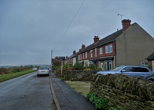
Wessington Green is a picturesque village located in Derbyshire, England. It is situated on the edge of the county's rolling hills and moorland, offering residents and visitors breathtaking views of the surrounding countryside. The village is part of the wider Wessington area, which encompasses both rural and residential areas.

Known for its natural beauty, Wessington Green is surrounded by lush green fields, meadows, and woodlands. The area is popular for hiking and walking enthusiasts, who can explore the nearby Derbyshire Dales and Peak District National Park. The village is home to a number of footpaths and trails that allow visitors to immerse themselves in the stunning landscapes.

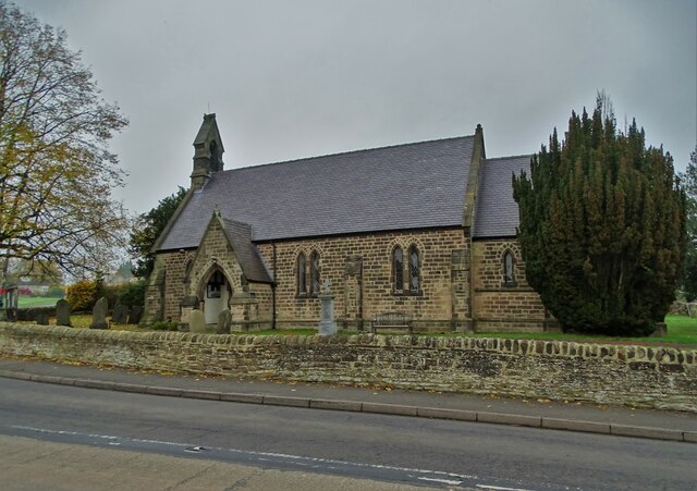
In terms of infrastructure, Wessington Green offers a range of amenities for its residents. These include a local primary school, a church, a post office, and a village hall that hosts various community events throughout the year. The village also benefits from good transportation links, with regular bus services connecting it to nearby towns and cities.

The community in Wessington Green is tight-knit and friendly, with a strong sense of community spirit. The village hosts annual events such as summer fairs and Christmas markets, which bring residents together and create a vibrant atmosphere. Additionally, there are local sports clubs and societies that cater to different interests, providing opportunities for residents to get involved and socialize.

Overall, Wessington Green is a charming village nestled amidst the natural beauty of Derbyshire's downs and moorland. It offers a peaceful and idyllic lifestyle for its residents, with plenty of outdoor activities and a close-knit community.

If you have any feedback on the listing, please let us know in the comments section below.

Wessington Green Images

Images are sourced within 2km of 53.114372/-1.4475694 or Grid Reference SK3757. Thanks to Geograph Open Source API. All images are credited.

Wessington Lane, South Wingfield
On Moorwood Moor Lane Looking back to Crich Lane Farm
On Moorwood Moor Lane
Looking back to Crich Lane Farm
Christ Church, Wessington In March 1859 the parish of Wessington was formed out of the parish of Crich. Christ Church Wessington which was built between 1857 and 1859 was dedicated by the Bishop of Derby. Further building work occurred in 1884 to increase the church's seating capacity to over two hundred.
Christ Church, Wessington
In March 1859 the parish of Wessington was formed out of the parish of Crich. Christ Church Wessington which was built between 1857 and 1859 was dedicated by the Bishop of Derby. Further building work occurred in 1884 to increase the church's seating capacity to over two hundred.
Railway bridge over Back Lane, Shirland It carries the main Midland railway linking Chesterfield and Derby.
Railway bridge over Back Lane, Shirland
It carries the main Midland railway linking Chesterfield and Derby.
North of Toadhole Furnace This farm track may follow the course of Icknield Street or Ryknild Street - a Roman road that ran from the south west of England to Yorkshire and possibly beyond
North of Toadhole Furnace
This farm track may follow the course of Icknield Street or Ryknild Street - a Roman road that ran from the south west of England to Yorkshire and possibly beyond
North of Toadhole Furnace Looking to the main Midland railway track that connects Chesterfield and Derby
North of Toadhole Furnace
Looking to the main Midland railway track that connects Chesterfield and Derby
The Amber Hotel at Toadhole Furnace
Grass field off Potter's Lane
Grass field off Inns Lane
Track near Hallfield Gate (Old Roman Road)
Railway embankment near Wessington
Footpath near Shirland
Minor road towards Wessington
Track to Broomhill Farm
Farmland near Broomhill Farm
Farm building, Cross Lane
Cross Lane, Wessington
Wessington Lane towards South Wingfield
Show me another place!

Wessington Green is located at Grid Ref: SK3757 (Lat: 53.114372, Lng: -1.4475694)

Administrative County: Derbyshire

District: North East Derbyshire

Police Authority: Derbyshire

What 3 Words

///headstone.bonfires.majoring. Near South Wingfield, Derbyshire

Related Wikis

Wessington

Wessington is a village and civil parish in the English county of Derbyshire. The population of the civil parish at the 2011 census was 576. It is in the...

Brackenfield

Brackenfield is a village and civil parish in the North East Derbyshire district of Derbyshire, England. The population of the civil parish as of the 2011...

Mathersgrave

Mathersgrave is a hamlet in Derbyshire, England. It consists of three houses on Mathers Grave Lane. This lane runs between the A615 Matlock road and School...

Wheatcroft, Derbyshire

Wheatcroft is a hamlet in the hills of Amber Valley, near Crich, Derbyshire, England. Wheatcroft has no shop or church and while it once had a chapel it...

Nearby Amenities

Located within 500m of 53.114372,-1.4475694
Wessington
Is In: Derbyshire, England, UK
Place: village
Wikidata: Q658183
Wikipedia: en:Wessington
Lat/Long: 53.1159685/-1.4466373
Barrier: stile
Steps: 1
Stile: wall
Lat/Long: 53.1169682/-1.4445637
Bench
Created By: Potlatch 0.10f
Lat/Long: 53.1157532/-1.4459006
Barrier: stile
Material: wood
Steps: 1
Stile: stepover
Lat/Long: 53.1146799/-1.4539763
Bench
Created By: Potlatch 0.10f
Lat/Long: 53.1168659/-1.4444587
Fast Food
Cuisine: fish_and_chips
Ele: 169.3166504
Lat/Long: 53.1161391/-1.4472384
Telephone
Defibrillator
Booth: K6
Colour: red
Covered: booth
Defibrillator Location: inside red phone box, Matlock Road, Wessington
Ele: 169.5568848
Emergency: defibrillator
Man Made: telephone_box
Old Phone: +44 1773 832153
Ref GB The Circuit: 448CCAF1-F86B-4FF6-A32F-B03500E22313
Lat/Long: 53.1158832/-1.4480143
Bench
Ele: 169.7972412
Lat/Long: 53.1160442/-1.4483576
Pub
Horse And Jockey
Addr City: Alfreton
Addr Postcode: DE55 6DW
Addr Street: Brackenfield Lane
Addr Village: Wessington
Beer Garden: yes
Contact Facebook: https://www.facebook.com/horseandjockeywessington
Fhrs Id: 933637
Food: yes
Outdoor Seating: yes
Parking: yes
Real Ale: Sharps Doom Bar, Castle Rock Kiss Me Kate
Website: https://www.horseandjockeywessington.co.uk/
Lat/Long: 53.1165331/-1.448382
Post Box
Brand: Royal Mail
Brand Wikidata: Q638098
Brand Wikipedia: en:Royal Mail
Operator: Royal Mail
Operator Wikidata: Q638098
Post Box Type: wall
Ref: DE55 411
Royal Cypher: GR
Royal Cypher Wikidata: Q33102273
Lat/Long: 53.1142233/-1.4442116
Bench
Ele: 162.1068115
Lat/Long: 53.1150868/-1.4457942
Ele: 161.8664551
Lat/Long: 53.1152405/-1.4456111
Post Box
Ele: 166.0000000
Post Box Design: type_m
Post Box Type: lamp
Ref: DE55 664
Lat/Long: 53.1166843/-1.4488009
Bus Stop
Bus: yes
Ele: 166.0000000
Public Transport: platform
Lat/Long: 53.1173153/-1.4490208
Ele: 157
Lat/Long: 53.1138711/-1.4480485
Barrier: cattle_grid
Ele: 148.0000000
Lat/Long: 53.1118419/-1.4486943
Ele: 147.0000000
Lat/Long: 53.1115152/-1.4484739
Barrier: stile
Ele: 147.0000000
Steps: 1
Stile: stepover
Lat/Long: 53.1115011/-1.4484867
Ele: 153
Lat/Long: 53.1128758/-1.4480629
Ele: 158
Lat/Long: 53.1143481/-1.4480471
Ele: 163
Lat/Long: 53.1151116/-1.4480612
Barrier: stile
Ele: 143.0000000
Steps: 1
Stile: stepover
Lat/Long: 53.110663/-1.4490737
Bench
Ele: 167.0000000
Lat/Long: 53.1161492/-1.448048
Bench
Ele: 158.0000000
Lat/Long: 53.1153438/-1.4462874
Bench
Ele: 153.0000000
Lat/Long: 53.115938/-1.4441809
Barrier: stile
Stile: stepover
Lat/Long: 53.1106481/-1.4436865
Information: board
Tourism: information
Lat/Long: 53.115885/-1.4449386
Barrier: stile
Material: wood
Source: survey;gps
Stile: stepover
Lat/Long: 53.1106663/-1.4435614
Bench
Source: survey;gps
Lat/Long: 53.114346/-1.4450693
Crich Lane Farm
Guest House: bed_and_breakfast
Tourism: guest_house
Lat/Long: 53.1114001/-1.449906
Power: pole
Lat/Long: 53.117445/-1.4424008
Historic: monument
Lat/Long: 53.1158562/-1.447414
Footway
Lat/Long: 53.1167342/-1.4441831
The data included in this document is from www.openstreetmap.org. The data is made available under ODbL.

Have you been to Wessington Green?

Leave your review of Wessington Green below (or comments, questions and feedback).