Wether Down

Downs, Moorland in Berkshire

England

Wether Down

Farmland: Lambourn This square contains the end of the village of Lambourn and farmland. This view taken from North Farm Close (the road between the B4001 and the minor road), looks north east across the field towards the top of the hill.
Farmland: Lambourn Credit: Pam Brophy

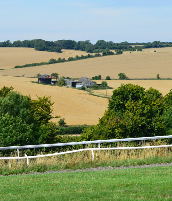
Wether Down, located in Berkshire, England, is a picturesque area that encompasses both downs and moorland. Spanning an approximate area of 500 hectares, it is situated within the stunning North Wessex Downs Area of Outstanding Natural Beauty (AONB).

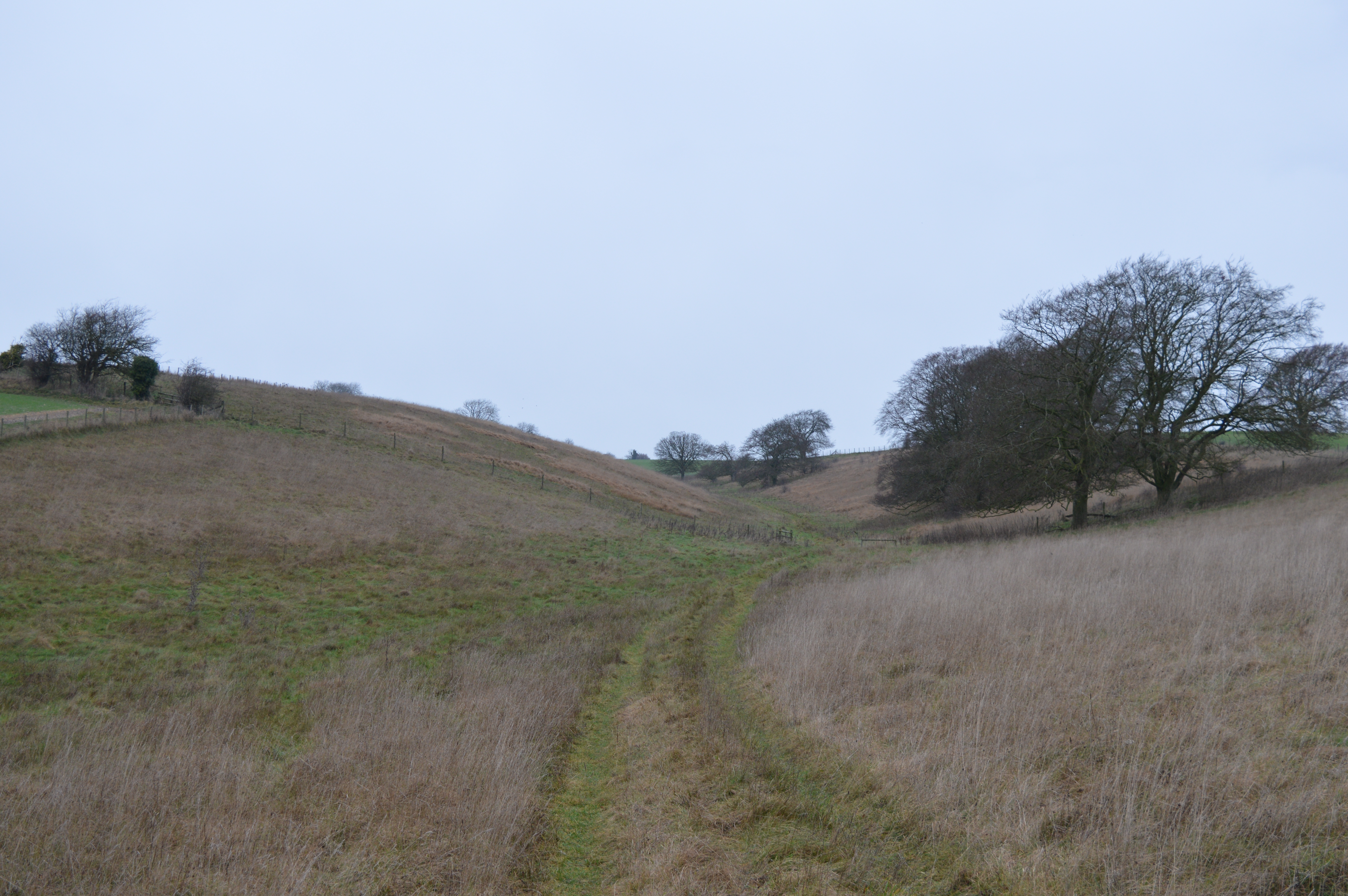
The downs of Wether Down are characterized by gently rolling hills, covered in lush green grasses and dotted with vibrant wildflowers during the spring and summer months. The landscape provides a tranquil and serene atmosphere, attracting visitors who seek to escape the hustle and bustle of urban life. The downs are also home to a variety of wildlife, including butterflies, birds, and grazing livestock, contributing to the area's biodiversity.

Adjacent to the downs, the moorland of Wether Down adds a unique element to the landscape. Here, visitors can experience a different terrain, characterized by heather-covered hillsides, scattered trees, and open expanses. Moorland habitats are essential for many bird species, including the iconic red grouse, which can often be spotted in the area.

Wether Down offers numerous opportunities for outdoor activities, such as walking, hiking, and birdwatching. Several well-marked trails traverse the downs and moorland, providing visitors with the chance to explore the area's natural beauty while enjoying panoramic views of the surrounding countryside.

Overall, Wether Down in Berkshire is a haven for nature lovers, offering a diverse range of habitats and breathtaking landscapes that make it an ideal destination for those seeking a peaceful and scenic retreat.

If you have any feedback on the listing, please let us know in the comments section below.

Wether Down Images

Images are sourced within 2km of 51.528678/-1.5297553 or Grid Reference SU3281. Thanks to Geograph Open Source API. All images are credited.

Farmland: Lambourn This square contains the end of the village of Lambourn and farmland. This view taken from North Farm Close (the road between the B4001 and the minor road), looks north east across the field towards the top of the hill.
Farmland: Lambourn
This square contains the end of the village of Lambourn and farmland. This view taken from North Farm Close (the road between the B4001 and the minor road), looks north east across the field towards the top of the hill.
Valley Equine Hospital This square consists of residences, farms and the Equine hospital. This view of the paddocks for horses "on the mend", is to the north of the hospital driveway, in the south western section of the square.
Valley Equine Hospital
This square consists of residences, farms and the Equine hospital. This view of the paddocks for horses "on the mend", is to the north of the hospital driveway, in the south western section of the square.
Stud Farm in the Valley of the Race Horse: Lambourn This stud farm (Neardown Stables), is to the south west of the B road in the north eastern corner of the square. The square is mostly Farmland and stables.
Stud Farm in the Valley of the Race Horse: Lambourn
This stud farm (Neardown Stables), is to the south west of the B road in the north eastern corner of the square. The square is mostly Farmland and stables.
The Malt Shovel Free House in Upper Lambourn
Houses, Lambourn At the northern extremity of the village. In the foreground are new houses on North Farm Close and climbing up the hillside are the less modern ones of Northfields.
Houses, Lambourn
At the northern extremity of the village. In the foreground are new houses on North Farm Close and climbing up the hillside are the less modern ones of Northfields.
The Malt Shovel, Upper Lambourn Once the village bakehouse now one of the favourite watering holes of the racing fraternity.  The building is Grade II listed.
The Malt Shovel, Upper Lambourn
Once the village bakehouse now one of the favourite watering holes of the racing fraternity. The building is Grade II listed.
Footpath, Upper Lambourn The footpath takes walkers from the Malt Shovel to the B4000.  There is a set of practice starting stalls used for training horse to jump off at the start of a race and to enter the stalls so that they can come under orders when they reach the racecourse.
Footpath, Upper Lambourn
The footpath takes walkers from the Malt Shovel to the B4000. There is a set of practice starting stalls used for training horse to jump off at the start of a race and to enter the stalls so that they can come under orders when they reach the racecourse.
Harvested field, Lambourn, Berkshire
Stables at Beechdown Farm
North Farm Close, Lambourn Looking into the small modern development on the site of an eponymous farm from the B4001 as it leaves the village.
North Farm Close, Lambourn
Looking into the small modern development on the site of an eponymous farm from the B4001 as it leaves the village.
Farmland, Lambourn Looking down on some large buildings at Whitehouse Farm in Upper Lambourn with a crop of peas in the foreground.
Farmland, Lambourn
Looking down on some large buildings at Whitehouse Farm in Upper Lambourn with a crop of peas in the foreground.
The Mile End Stream at North Farm The Mile End Stream is an ephemeral groundwater fed chalk stream which only flows in exceptionally wet years when the water table is unusually high.
The Mile End Stream at North Farm
The Mile End Stream is an ephemeral groundwater fed chalk stream which only flows in exceptionally wet years when the water table is unusually high.
North Farm OBH In the kiosk is an observation borehole (OBH) used by the Environment Agency for monitoring groundwater levels in the chalk aquifer.
Not that you could get to it just now as it's on an island in the Mile End stream, itself a result of high groundwater.
North Farm OBH
In the kiosk is an observation borehole (OBH) used by the Environment Agency for monitoring groundwater levels in the chalk aquifer. Not that you could get to it just now as it's on an island in the Mile End stream, itself a result of high groundwater.
Malt Shovel Lane, Upper Lambourn The pub and its lane.
Malt Shovel Lane, Upper Lambourn
The pub and its lane.
Sheepdrove Road passes a communications mast
Sheepcote drove Road north of Isbury Farm
Gallop, Lambourn, Berkshire
Chapel Forge farriery, Upper Lambourn Former non-conformist chapel of St. Luke, now a farriery.
Chapel Forge farriery, Upper Lambourn
Former non-conformist chapel of St. Luke, now a farriery.
Show me another place!

Wether Down is located at Grid Ref: SU3281 (Lat: 51.528678, Lng: -1.5297553)

Unitary Authority: West Berkshire

Police Authority: Thames Valley

What 3 Words

///undertook.quack.surveyed. Near Lambourn, Berkshire

Related Wikis

Croker's Hole

Croker's Hole is a 4.4-hectare (11-acre) biological Site of Special Scientific Interest north of Upper Lambourn in Berkshire.The site is a narrow grassland...

Upper Lambourn

Upper Lambourn is a small village in the county of Berkshire, England. The village is situated in the civil parish of Lambourn , and is 1.2 miles (2 km...

Seven Barrows

Seven Barrows is a Bronze Age bowl barrow cemetery, 4-hectare (9.9-acre) of which are designated a biological Site of Special Scientific Interest, at Upper...

Lambourn

Lambourn is a village and civil parish in Berkshire, England. It lies just north of the M4 Motorway between Swindon and Newbury, and borders Wiltshire...

Nearby Amenities

Located within 500m of 51.528678,-1.5297553
Trabb's Farm
Landuse: farm
Note Retag: CS #48756035
Source: OS OpenData StreetView
Lat/Long: 51.5327223/-1.5301702
Newbarn Farm
Landuse: farm
Note Retag: CS #48756035
Source: OS OpenData StreetView
Lat/Long: 51.5245265/-1.530256
Power: pole
Source: Bing
Lat/Long: 51.530683/-1.52696
Power: pole
Source: Bing
Lat/Long: 51.5313489/-1.5272952
Power: pole
Source: Bing
Lat/Long: 51.5320029/-1.5275903
Power: pole
Source: Bing
Lat/Long: 51.5300039/-1.52663
Power: pole
Source: Bing
Lat/Long: 51.5292865/-1.5262975
Power: pole
Source: Bing
Lat/Long: 51.5330507/-1.5281079
Power: pole
Source: Bing
Lat/Long: 51.5326537/-1.5286042
Mile End Farm House
Addr Housename: Mile End Farm House
Building: house
Source: OS OpenData StreetView
Lat/Long: 51.5272672/-1.5229867
Trabb's Farm House
Addr Housename: Trabb's Farm House
Building: house
Source: OS OpenData StreetView
Lat/Long: 51.5327956/-1.5275615
Mile End
Place: hamlet
Source: OS OpenData StreetView
Lat/Long: 51.5260323/-1.5248321
Wether Down
Place: locality
Source: OS OpenData StreetView
Lat/Long: 51.5289712/-1.5294927
Post Box
Post Box Type: lamp
Ref: RG17 248
Royal Cypher: EIIR
Royal Cypher Wikidata: Q33102113
Lat/Long: 51.5269269/-1.5235725
The data included in this document is from www.openstreetmap.org. The data is made available under ODbL.

Have you been to Wether Down?

Leave your review of Wether Down below (or comments, questions and feedback).