Ablington Downs
Downs, Moorland in Gloucestershire Cotswold
England
Ablington Downs
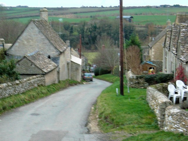
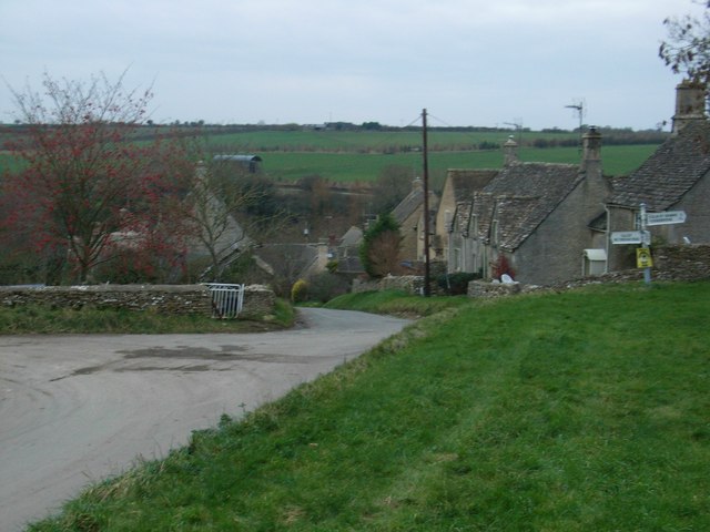
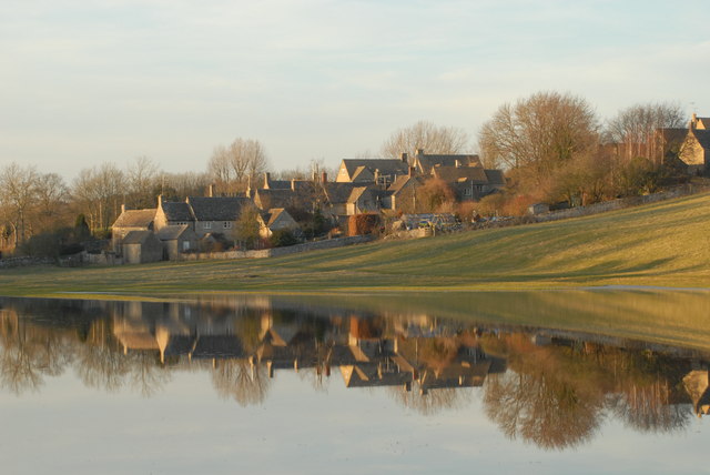
Ablington Downs is a picturesque area located in Gloucestershire, England. Situated in the Cotswolds, it is renowned for its stunning downs and moorland landscapes. Covering an extensive area, Ablington Downs offers visitors panoramic views of the surrounding countryside, making it a popular destination for nature lovers and hikers.
The downs of Ablington Downs are characterized by their rolling hills and open grassland, which are home to a diverse range of flora and fauna. The area is particularly known for its abundance of wildflowers, including orchids and buttercups, creating vibrant splashes of color throughout the landscape. These downs provide important habitats for various bird species, such as skylarks and meadow pipits, making it a haven for birdwatching enthusiasts.
Ablington Downs also features vast moorland areas, which are characterized by their heather-covered expanses. This unique habitat supports a variety of wildlife, including red grouse and rabbits. The moorland is dotted with rocky outcrops, adding to its rugged beauty.
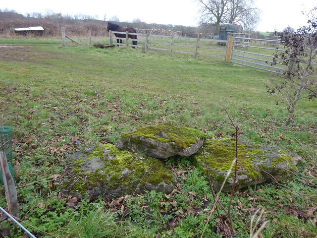
Aside from its natural attractions, Ablington Downs boasts historical significance. The area is home to ancient burial mounds and prehistoric earthworks, indicating human settlement dating back thousands of years. These archaeological sites provide insight into the region's rich cultural heritage.
Ablington Downs offers a tranquil and idyllic escape from the hustle and bustle of city life. Whether it's exploring the vast downs, admiring the wildflowers, or immersing in the area's history, visitors to Ablington Downs are guaranteed a memorable experience in the heart of Gloucestershire's picturesque countryside.
If you have any feedback on the listing, please let us know in the comments section below.
Ablington Downs Images
Images are sourced within 2km of 51.776975/-1.8600404 or Grid Reference SP0908. Thanks to Geograph Open Source API. All images are credited.
![A circular walk around Bibury and Ablington [4] The path passes through a kissing gate at the side of this large electric gate.
The walk starts at Arlington Corner and follows a footpath to Ablington, where the River Coln is crossed, and then a byway northeast to Saltway Barn. Another byway, the historic Salt Way, is then followed southeast before a right turn onto a bridleway which runs south past Hale Barn to Bibury. The River Coln is recrossed at Bibury Mill and a footpath is then followed back to the starting point. Just over 5 miles.](https://s3.geograph.org.uk/geophotos/07/48/92/7489299_5eae3bf9.jpg)
![A circular walk around Bibury and Ablington [5] Black sheep and lambs alongside the path.
The walk starts at Arlington Corner and follows a footpath to Ablington, where the River Coln is crossed, and then a byway northeast to Saltway Barn. Another byway, the historic Salt Way, is then followed southeast before a right turn onto a bridleway which runs south past Hale Barn to Bibury. The River Coln is recrossed at Bibury Mill and a footpath is then followed back to the starting point. Just over 5 miles.](https://s2.geograph.org.uk/geophotos/07/48/93/7489302_4165ff1b.jpg)
![A circular walk around Bibury and Ablington [6] The path passes through this small copse.
The walk starts at Arlington Corner and follows a footpath to Ablington, where the River Coln is crossed, and then a byway northeast to Saltway Barn. Another byway, the historic Salt Way, is then followed southeast before a right turn onto a bridleway which runs south past Hale Barn to Bibury. The River Coln is recrossed at Bibury Mill and a footpath is then followed back to the starting point. Just over 5 miles.](https://s0.geograph.org.uk/geophotos/07/48/93/7489304_63fe2f3e.jpg)
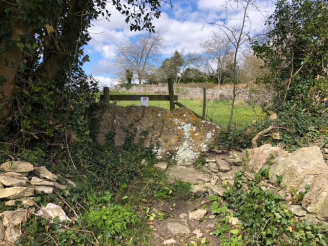
![A circular walk around Bibury and Ablington [7] A stile and then a gate take the footpath to the crossing of the track.
The walk starts at Arlington Corner and follows a footpath to Ablington, where the River Coln is crossed, and then a byway northeast to Saltway Barn. Another byway, the historic Salt Way, is then followed southeast before a right turn onto a bridleway which runs south past Hale Barn to Bibury. The River Coln is recrossed at Bibury Mill and a footpath is then followed back to the starting point. Just over 5 miles.](https://s0.geograph.org.uk/geophotos/07/48/93/7489312_663e720a.jpg)
![A circular walk around Bibury and Ablington [8] The footpath cross this track, seen here looking northeast.
The walk starts at Arlington Corner and follows a footpath to Ablington, where the River Coln is crossed, and then a byway northeast to Saltway Barn. Another byway, the historic Salt Way, is then followed southeast before a right turn onto a bridleway which runs south past Hale Barn to Bibury. The River Coln is recrossed at Bibury Mill and a footpath is then followed back to the starting point. Just over 5 miles.](https://s2.geograph.org.uk/geophotos/07/48/93/7489314_97bec6f5.jpg)
![A circular walk around Bibury and Ablington [9] The footpath cross this track, seen here looking southwest.
The walk starts at Arlington Corner and follows a footpath to Ablington, where the River Coln is crossed, and then a byway northeast to Saltway Barn. Another byway, the historic Salt Way, is then followed southeast before a right turn onto a bridleway which runs south past Hale Barn to Bibury. The River Coln is recrossed at Bibury Mill and a footpath is then followed back to the starting point. Just over 5 miles.](https://s3.geograph.org.uk/geophotos/07/48/93/7489315_d86821e5.jpg)
![A circular walk around Bibury and Ablington [10] Difficult to see from ground level, this is Rawbarrow or Ablington Camp, a slight univallate hillfort situated on the summit of a ridge which also forms the southern valley side of the River Coln. A roughly oval enclosure of approximately 11 acres (4.4ha) the earthworks are best preserved on the eastern side as a bank of up to 30 feet (9 metres) wide and 6 feet (1.7 metres) high. A Scheduled Ancient Monument with details at: <span class="nowrap"><a title="https://historicengland.org.uk/listing/the-list/list-entry/1003356" rel="nofollow ugc noopener" href="https://historicengland.org.uk/listing/the-list/list-entry/1003356">Link</a><img style="margin-left:2px;" alt="External link" title="External link - shift click to open in new window" src="https://s1.geograph.org.uk/img/external.png" width="10" height="10"/></span>](https://s0.geograph.org.uk/geophotos/07/48/93/7489316_90b88654.jpg)
![A circular walk around Bibury and Ablington [11] Difficult to see from ground level, this is Rawbarrow or Ablington Camp, a slight univallate hillfort situated on the summit of a ridge which also forms the southern valley side of the River Coln. A roughly oval enclosure of approximately 11 acres (4.4ha) the earthworks are best preserved on the eastern side as a bank of up to 30 feet (9 metres) wide and 6 feet (1.7 metres) high. A Scheduled Ancient Monument with details at: <span class="nowrap"><a title="https://historicengland.org.uk/listing/the-list/list-entry/1003356" rel="nofollow ugc noopener" href="https://historicengland.org.uk/listing/the-list/list-entry/1003356">Link</a><img style="margin-left:2px;" alt="External link" title="External link - shift click to open in new window" src="https://s1.geograph.org.uk/img/external.png" width="10" height="10"/></span>](https://s1.geograph.org.uk/geophotos/07/48/93/7489317_3149e33e.jpg)
![A circular walk around Bibury and Ablington [12] The footpath from Arlington Corner meet the minor road at Ablington.
The walk starts at Arlington Corner and follows a footpath to Ablington, where the River Coln is crossed, and then a byway northeast to Saltway Barn. Another byway, the historic Salt Way, is then followed southeast before a right turn onto a bridleway which runs south past Hale Barn to Bibury. The River Coln is recrossed at Bibury Mill and a footpath is then followed back to the starting point. Just over 5 miles.](https://s2.geograph.org.uk/geophotos/07/48/93/7489318_31443d2d.jpg)
![A circular walk around Bibury and Ablington [13] After passing through Ablington Village, the walk now follows a restricted byway which leads northeast to Saltway Barn.
The walk starts at Arlington Corner and follows a footpath to Ablington, where the River Coln is crossed, and then a byway northeast to Saltway Barn. Another byway, the historic Salt Way, is then followed southeast before a right turn onto a bridleway which runs south past Hale Barn to Bibury. The River Coln is recrossed at Bibury Mill and a footpath is then followed back to the starting point. Just over 5 miles.](https://s2.geograph.org.uk/geophotos/07/48/93/7489326_08bc7578.jpg)
![A circular walk around Bibury and Ablington [14] The track, a restricted byway, runs along the field edge on its way to Saltway Barn.
The walk starts at Arlington Corner and follows a footpath to Ablington, where the River Coln is crossed, and then a byway northeast to Saltway Barn. Another byway, the historic Salt Way, is then followed southeast before a right turn onto a bridleway which runs south past Hale Barn to Bibury. The River Coln is recrossed at Bibury Mill and a footpath is then followed back to the starting point. Just over 5 miles.](https://s0.geograph.org.uk/geophotos/07/48/93/7489328_a152267d.jpg)
![A circular walk around Bibury and Ablington [15] The track continues northeast towards Saltway Barn. Gore Hill Covert is seen in the distance.
The walk starts at Arlington Corner and follows a footpath to Ablington, where the River Coln is crossed, and then a byway northeast to Saltway Barn. Another byway, the historic Salt Way, is then followed southeast before a right turn onto a bridleway which runs south past Hale Barn to Bibury. The River Coln is recrossed at Bibury Mill and a footpath is then followed back to the starting point. Just over 5 miles.](https://s1.geograph.org.uk/geophotos/07/48/93/7489329_d99739a6.jpg)
Ablington Downs is located at Grid Ref: SP0908 (Lat: 51.776975, Lng: -1.8600404)
Administrative County: Gloucestershire
District: Cotswold
Police Authority: Gloucestershire
What 3 Words
///developer.brink.hardly. Near Northleach, Gloucestershire
Nearby Locations
Related Wikis


Nearby Amenities
Located within 500m of 51.776975,-1.8600404Have you been to Ablington Downs?
Leave your review of Ablington Downs below (or comments, questions and feedback).