Middleway Meadows

Downs, Moorland in Yorkshire

England

Middleway Meadows

Keighley Road, Silsden Looking towards the entrance to Aldi supermarket.
Keighley Road, Silsden Credit: Mark Anderson

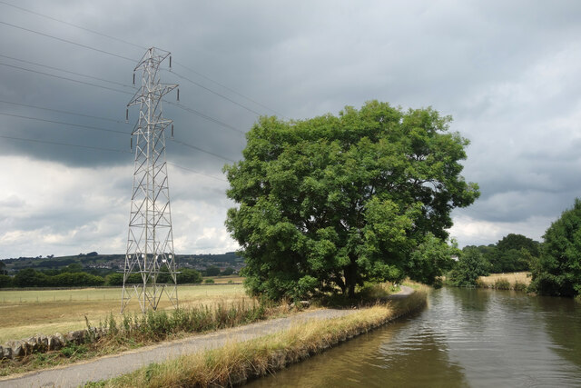
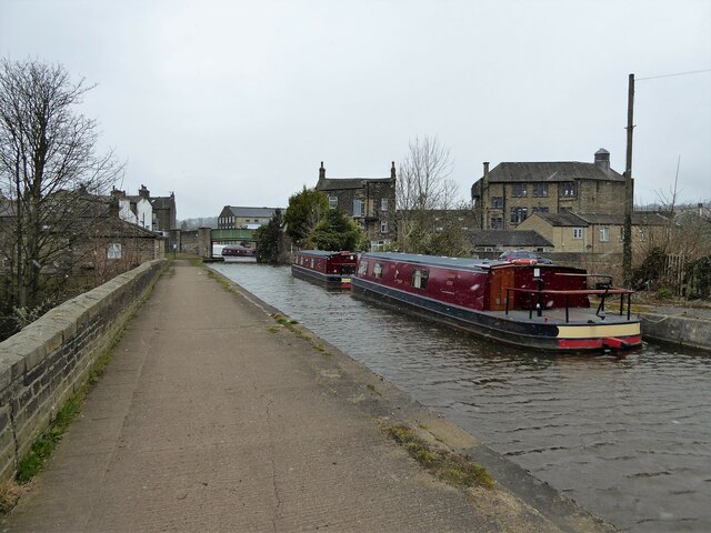
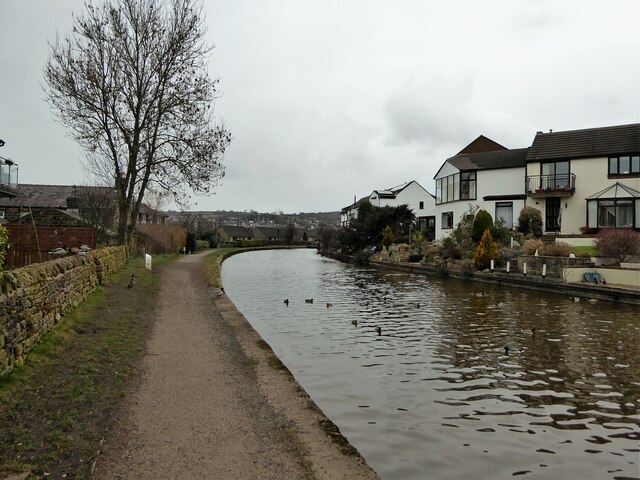
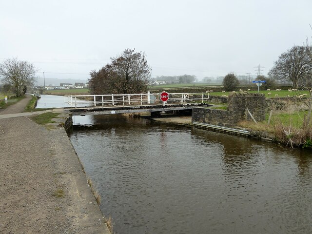
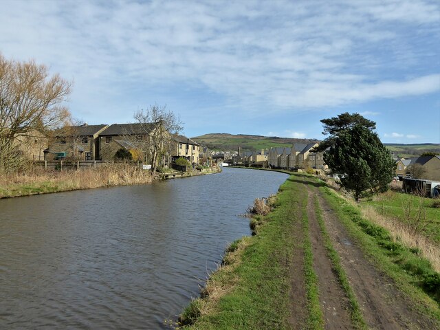
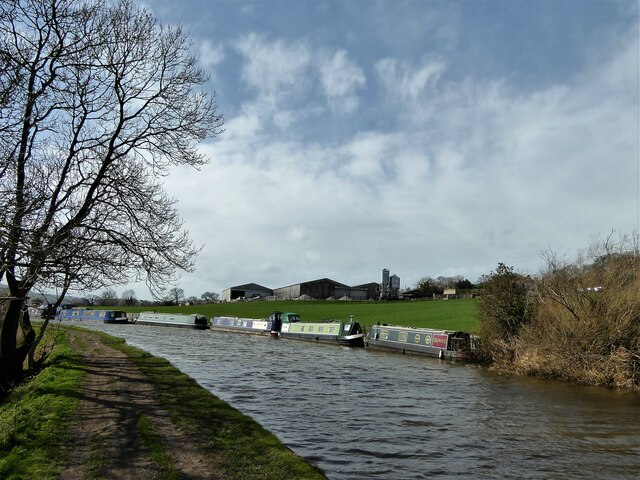
Middleway Meadows is a picturesque area located in Yorkshire, England. Nestled between the rolling hills and vast moorland, it offers a stunning natural landscape with a rich diversity of flora and fauna. The meadows are situated in the heart of the Yorkshire Downs, offering breathtaking views of the surrounding countryside.

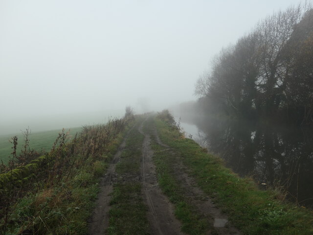
The area is known for its tranquil and peaceful atmosphere, making it a popular destination for nature lovers and outdoor enthusiasts. The meadows are crisscrossed by a network of well-maintained walking trails, allowing visitors to explore the area at their own pace. These trails take you through lush green fields, wildflower meadows, and along babbling brooks, immersing you in the beauty of the countryside.

Middleway Meadows is also home to a wide range of wildlife, providing ample opportunities for nature spotting. Visitors may catch a glimpse of rabbits, hares, foxes, and a variety of bird species. The moorland surrounding the meadows is particularly renowned for its population of rare bird species, making it a haven for birdwatchers.

In addition to its natural beauty, Middleway Meadows offers a range of amenities for visitors. There are picnic areas where visitors can relax and enjoy a meal amidst the idyllic surroundings. The meadows are also equipped with designated parking areas and restroom facilities to ensure visitors' comfort.

Overall, Middleway Meadows is a haven of tranquility and natural beauty, offering a unique experience for those seeking to escape the hustle and bustle of daily life and immerse themselves in the splendor of Yorkshire's Downs and Moorland.

If you have any feedback on the listing, please let us know in the comments section below.

Middleway Meadows Images

Images are sourced within 2km of 53.913531/-1.9300871 or Grid Reference SE0446. Thanks to Geograph Open Source API. All images are credited.

Keighley Road, Silsden Looking towards the entrance to Aldi supermarket.
Keighley Road, Silsden
Looking towards the entrance to Aldi supermarket.
Keighley Road, Silsden approaching Elliott Street Elliott Street is on the left. The temporary traffic lights are for some road works on St John's Street on the right.
Keighley Road, Silsden approaching Elliott Street
Elliott Street is on the left. The temporary traffic lights are for some road works on St John's Street on the right.
Elliott Street, Silsden near Prince Street
Sunday football at Silsden AFC Some junior football players are taking a break.
Sunday football at Silsden AFC
Some junior football players are taking a break.
The Leeds and Liverpool Canal, Silsden Under the bridge carrying Keighley Road (A6034).
The Leeds and Liverpool Canal, Silsden
Under the bridge carrying Keighley Road (A6034).
Old milestone One of the 615 milestones set up by the newly formed West Riding County Council in 1893/94.  This route extends from Addingham through Silsden and Glusburn to the county boundary with Lancashire on the A6068.  It is on the east side of Bolton Road near the entrance to Cringles Park Home Estate.  It is Grade II listed 1223253.
Old milestone
One of the 615 milestones set up by the newly formed West Riding County Council in 1893/94. This route extends from Addingham through Silsden and Glusburn to the county boundary with Lancashire on the A6068. It is on the east side of Bolton Road near the entrance to Cringles Park Home Estate. It is Grade II listed 1223253.
Old milestone On the south-east side of Bolton Road at the northern end of Silsden is this West Riding County Council stone from 1893/94.  Although the pavement has been built up over the years all the legends are still visible.   It is not known at which foundry the castings on this route were forged.
Old milestone
On the south-east side of Bolton Road at the northern end of Silsden is this West Riding County Council stone from 1893/94. Although the pavement has been built up over the years all the legends are still visible. It is not known at which foundry the castings on this route were forged.
Old milestone This West Riding County Council milestone set up in 1893/94 is on the east side of the A6034, Keighley Road, south of Silsden, overlooking the golf course.   About 15cm of the casting which is attached to a longer backing stone is now under pavement level.
Old milestone
This West Riding County Council milestone set up in 1893/94 is on the east side of the A6034, Keighley Road, south of Silsden, overlooking the golf course. About 15cm of the casting which is attached to a longer backing stone is now under pavement level.
Leeds & Liverpool Canal near Silsden
Silsden - Town Centre Conservative Club and The Punchbowl pub at the top of the Kirkgate.
Silsden - Town Centre
Conservative Club and The Punchbowl pub at the top of the Kirkgate.
Silsden - St James Church The parish church dates from 1712 and was originally a chapel of ease for Kildwick.
 <span class="nowrap"><a title="www.silsdenhistorygroup.co.uk" rel="nofollow ugc noopener" href="http://www.silsdenhistorygroup.co.uk">Link</a><img style="margin-left:2px;" alt="External link" title="External link - shift click to open in new window" src="https://s1.geograph.org.uk/img/external.png" width="10" height="10"/></span>
Silsden - St James Church
The parish church dates from 1712 and was originally a chapel of ease for Kildwick. LinkExternal link
One misty moisty morning on the towpath near Silsden No sign of an old man clothed in leather!. More prosaically, this is the Leeds & Liverpool canal, between bridges 191A and 191 on a late November morning.
One misty moisty morning on the towpath near Silsden
No sign of an old man clothed in leather!. More prosaically, this is the Leeds & Liverpool canal, between bridges 191A and 191 on a late November morning.
Apple tree, by Cowling swingbridge [no 191] Not crab apples, but sweet little eating apples. Its rare to see so many apples still on their tree at the end of November.
Apple tree, by Cowling swingbridge [no 191]
Not crab apples, but sweet little eating apples. Its rare to see so many apples still on their tree at the end of November.
Leeds & Liverpool Canal View along the trough of the aqueduct across Hainsworth Road on a snowy day.
Leeds & Liverpool Canal
View along the trough of the aqueduct across Hainsworth Road on a snowy day.
Leeds & Liverpool Canal Following the contour towards Silsden and now lined with new housing
Leeds & Liverpool Canal
Following the contour towards Silsden and now lined with new housing
Brunthwaite Bridge No.192 A swing bridge on the Leeds & Liverpool Canal
Brunthwaite Bridge No.192
A swing bridge on the Leeds & Liverpool Canal
Leeds and Liverpool Canal Approaching Silsden from the Kildwick direction
Leeds and Liverpool Canal
Approaching Silsden from the Kildwick direction
Woodside Moorings On the Leeds & Liverpool Canal
Woodside Moorings
On the Leeds & Liverpool Canal
Show me another place!

Middleway Meadows is located at Grid Ref: SE0446 (Lat: 53.913531, Lng: -1.9300871)

Division: West Riding

Unitary Authority: Bradford

Police Authority: West Yorkshire

What 3 Words

///shock.sorters.sock. Near Silsden, West Yorkshire

Related Wikis

Silsden

Silsden is a town and civil parish in the City of Bradford in West Yorkshire, England, on the River Aire and Leeds and Liverpool Canal between Keighley...

Silsden Town Hall

Silsden Town Hall is a municipal building in Kirkgate, Silsden, West Yorkshire, England. The town hall is the meeting place of Silsden Town Council....

Silsden A.F.C.

Silsden A.F.C. is a football club based in Silsden, West Yorkshire, England, and is currently a member of the Northern Counties East League Premier Division...

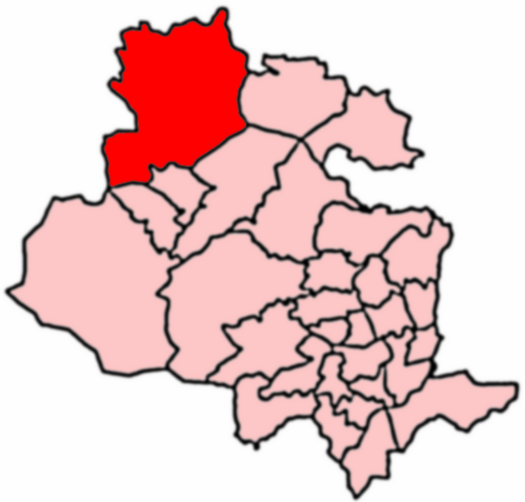
Craven (Bradford ward)

Craven is an electoral ward within the City of Bradford Metropolitan District Council, West Yorkshire, England. The population of the ward at the 2011...

Nearby Amenities

Located within 500m of 53.913531,-1.9300871
Silsden
Is In: UK, England,Yorkshire,West Yorkshire, Airedale
Is In Country: UK
Is In County: West Yorkshire
Is In Historical County: Yorkshire
Place: village
Wikidata: Q2472743
Wikipedia: en:Silsden
Lat/Long: 53.913185/-1.9374737
Brunthwaite
Is In: UK,England,Yorkshire,West Yorkshire,Airedale
Is In County: West Yorkshire
Is In Historical County: Yorkshire
Is In Municipality: Bradford
Place: hamlet
Population: 50
Lat/Long: 53.9124072/-1.9246184
Barrier: stile
Stile: hipster
Lat/Long: 53.9172812/-1.9284169
Barrier: stile
Stile: hipster
Lat/Long: 53.9172749/-1.9302564
Bus Stop
Bolton Road Pickard Lane
Bus: yes
Departures Board: timetable
Local Ref: 45016909
Naptan AtcoCode: 450016909
Naptan Bearing: SW
Naptan CommonName: Bolton Road Pickard Lane
Naptan Crossing: Pickard Lane
Naptan Indicator: Stop 45016909
Naptan Notes: L/C 516
Naptan PlusbusZoneRef: LEEDS
Naptan ShortCommonName: Pickard Lane
Naptan Street: Bolton Road
Naptan Verified: yes
Public Transport: platform
Shelter: no
Source: naptan_import
Lat/Long: 53.916677/-1.9341204
Bus Stop
Bolton Road Pickard Lane
Bus: yes
Departures Board: timetable
Local Ref: 45016910
Naptan AtcoCode: 450016910
Naptan Bearing: NE
Naptan CommonName: Bolton Road Pickard Lane
Naptan Crossing: Pickard Lane
Naptan Indicator: Stop 45016910
Naptan Notes: L/C 505
Naptan PlusbusZoneRef: LEEDS
Naptan ShortCommonName: Pickard Lane
Naptan Street: Bolton Road
Naptan Verified: yes
Public Transport: platform
Shelter: no
Source: naptan_import
Lat/Long: 53.9164835/-1.9347509
Bus Stop
Bolton Road Bell Square
Bus: yes
Local Ref: 45016911
Naptan AtcoCode: 450016911
Naptan Bearing: NE
Naptan CommonName: Bolton Road Bell Square
Naptan Crossing: Bell Square
Naptan Indicator: Stop 45016911
Naptan Landmark: Kings Arms PH
Naptan PlusbusZoneRef: LEEDS
Naptan ShortCommonName: Bell Square S3
Naptan Street: Bolton Road
Naptan Verified: no
Public Transport: platform
Source: naptan_import
Lat/Long: 53.9152405/-1.9371372
Power: pole
Source: OS 1:25k
Lat/Long: 53.9132549/-1.9263324
Power: pole
Source: OS 1:25k
Lat/Long: 53.9150629/-1.929757
Power: pole
Source: OS 1:25k
Lat/Long: 53.9146636/-1.9299438
Power: pole
Source: OS 1:25k
Lat/Long: 53.9132895/-1.9316022
Power: pole
Source: OS 1:25k
Lat/Long: 53.9118603/-1.9256937
Power: pole
Source: OS 1:25k
Lat/Long: 53.9174371/-1.931555
Recycling
Recycling Cans: yes
Recycling Clothes: yes
Recycling Glass: yes
Recycling Paper: yes
Lat/Long: 53.9147074/-1.9369395
Turning Circle
Lat/Long: 53.9129335/-1.9325164
Turning Circle
Lat/Long: 53.9101469/-1.9302447
Turning Circle
Lat/Long: 53.9099646/-1.9275545
Turning Circle
Lat/Long: 53.9095979/-1.9308782
Turning Circle
Lat/Long: 53.9118527/-1.9334423
Turning Circle
Lat/Long: 53.9168467/-1.9320015
Turning Circle
Lat/Long: 53.9161124/-1.9328643
Turning Circle
Lat/Long: 53.909848/-1.9330271
Power: pole
Lat/Long: 53.9139388/-1.9288764
Power: pole
Lat/Long: 53.9103405/-1.9248162
Power: pole
Lat/Long: 53.913548/-1.9261048
Power: pole
Lat/Long: 53.9142092/-1.9281798
Noexit: yes
Lat/Long: 53.9125619/-1.9365896
Post Box
Source: survey
Lat/Long: 53.9166491/-1.9341487
Post Box
Source: survey
Lat/Long: 53.9108972/-1.9328204
Bus Stop
Bolton Road Silsden
Bus: yes
Local Ref: 45050467
Naptan AtcoCode: 450050467
Naptan Bearing: SW
Naptan BusStopType: CUS
Naptan CommonName: Bolton Road Silsden
Naptan Indicator: Stop 45050467
Naptan PlusbusZoneRef: LEEDS
Naptan ShortCommonName: Brown Bank Lane
Naptan Street: Bolton Road
Naptan Verified: yes
Physically Present: no
Public Transport: platform
Source: naptan_import
Lat/Long: 53.9178628/-1.9317863
Post Box
Post Box Type: wall
Royal Cypher: EIIR
Royal Cypher Wikidata: Q33102113
Lat/Long: 53.9134962/-1.937525
Historic: memorial
Lat/Long: 53.9146698/-1.937171
Barrier: stile;gate
Lat/Long: 53.9143214/-1.9302135
Noexit: yes
Lat/Long: 53.9125604/-1.9365132
Bench
Lat/Long: 53.9130366/-1.9374858
Bench
Lat/Long: 53.9130178/-1.9374333
Parking
Parking: surface
Lat/Long: 53.9112145/-1.9350887
Power: pole
Lat/Long: 53.9173632/-1.9292861
Power: pole
Lat/Long: 53.916428/-1.9294873
Querrel Hill
Place: locality
Source: OS sheet 185, publ. 1848
Lat/Long: 53.9164871/-1.9345077
Generator Method: photovoltaic
Generator Output Electricity: yes
Generator Source: solar
Generator Type: solar_photovoltaic_panel
Power: generator
Lat/Long: 53.9123612/-1.9328315
Parking
Parking: surface
Lat/Long: 53.9111789/-1.9277672
Turning Circle
Lat/Long: 53.9141252/-1.9306319
Generator Method: photovoltaic
Generator Output Electricity: yes
Generator Source: solar
Generator Type: solar_photovoltaic_panel
Power: generator
Lat/Long: 53.9155759/-1.9359732
Crossing
Crossing: traffic_signals
Lat/Long: 53.9151741/-1.9371548
Generator Method: photovoltaic
Generator Output Electricity: yes
Generator Source: solar
Generator Type: solar_photovoltaic_panel
Power: generator
Lat/Long: 53.9138352/-1.9373958
Power: pole
Lat/Long: 53.9103037/-1.9346988
Power: pole
Lat/Long: 53.9101189/-1.9350395
Post Box
Operator: Royal Mail
Operator Wikidata: Q638098
Lat/Long: 53.9132287/-1.9374663
Waterway: milestone
Lat/Long: 53.9113092/-1.936695
The data included in this document is from www.openstreetmap.org. The data is made available under ODbL.

Have you been to Middleway Meadows?

Leave your review of Middleway Meadows below (or comments, questions and feedback).