Brownsey Moor

Downs, Moorland in Yorkshire Richmondshire

England

Brownsey Moor

Old Gang Smelting Mill (1) Ruins of a once thriving lead smelting operation, which brought much prosperity to the area in the 19th Century.
Grade II Listed building, thus hoping this will ensure no more deterioration will take place.
Wainwright's Coast to Coast walk passes by.
Old Gang Smelting Mill (1) Credit: Chris Heaton

Brownsey Moor is a picturesque area located in Yorkshire, England, known for its stunning natural beauty and diverse ecosystems. Covering a vast expanse of land, the moor is characterized by rolling hills, expansive valleys, and heather-covered moorland.

The moor is situated within the Yorkshire Dales National Park, which adds to its protected status and ensures its preservation for generations to come. The area is home to a wide range of plant and animal species, making it a haven for nature enthusiasts and wildlife lovers. Visitors can expect to see an array of bird species, including curlews, lapwings, and red grouse, as well as various mammals such as hares and deer.

Brownsey Moor offers a unique landscape, with its heather-covered hills providing a striking contrast against the clear blue skies. During the summer months, the moor is a haven for wildflowers, painting the landscape with vibrant colors. The area also boasts numerous walking trails, allowing visitors to explore its beauty while taking in breathtaking views of the surrounding countryside.

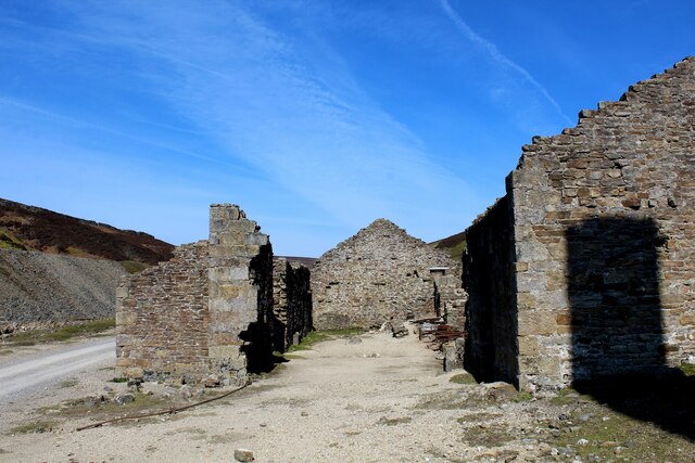
In addition to its natural wonders, Brownsey Moor also holds historical significance. Ancient burial mounds and stone circles can be found scattered across the moor, providing a glimpse into the area's rich past. These historical artifacts serve as a reminder of the human presence in the region dating back thousands of years.

Overall, Brownsey Moor is a must-visit destination for those seeking a true taste of Yorkshire's natural beauty. With its diverse ecosystems, stunning vistas, and historical significance, this moorland truly offers a unique and enriching experience for all who venture there.

If you have any feedback on the listing, please let us know in the comments section below.

Brownsey Moor Images

Images are sourced within 2km of 54.390145/-2.048983 or Grid Reference SD9699. Thanks to Geograph Open Source API. All images are credited.

Old Gang Smelting Mill (1) Ruins of a once thriving lead smelting operation, which brought much prosperity to the area in the 19th Century.
Grade II Listed building, thus hoping this will ensure no more deterioration will take place.
Wainwright's Coast to Coast walk passes by.
Old Gang Smelting Mill (1)
Ruins of a once thriving lead smelting operation, which brought much prosperity to the area in the 19th Century. Grade II Listed building, thus hoping this will ensure no more deterioration will take place. Wainwright's Coast to Coast walk passes by.
Old Gang Smelting Mill (2) Ruins of a once thriving lead smelting operation, which brought much prosperity to the area in the 19th Century.
Grade II Listed building, thus hoping this will ensure no more deterioration will take place.
Wainwright's Coast to Coast walk passes by.
Old Gang Smelting Mill (2)
Ruins of a once thriving lead smelting operation, which brought much prosperity to the area in the 19th Century. Grade II Listed building, thus hoping this will ensure no more deterioration will take place. Wainwright's Coast to Coast walk passes by.
Old Gang Smelting Mill (3) Ruins of a once thriving lead smelting operation, which brought much prosperity to the area in the 19th Century.
Grade II Listed building, thus hoping this will ensure no more deterioration will take place.
Wainwright's Coast to Coast walk passes by.
Old Gang Smelting Mill (3)
Ruins of a once thriving lead smelting operation, which brought much prosperity to the area in the 19th Century. Grade II Listed building, thus hoping this will ensure no more deterioration will take place. Wainwright's Coast to Coast walk passes by.
Shooting Hut beside Old Gang Beck Amidst the ruins of the Old Gang Smelting Mill complex, there appears to be one structure in one piece - a luncheon hut for the shooting fraternity, which is of very much more recent construction
Shooting Hut beside Old Gang Beck
Amidst the ruins of the Old Gang Smelting Mill complex, there appears to be one structure in one piece - a luncheon hut for the shooting fraternity, which is of very much more recent construction
Bridge across Old Gang Beck Stone bridge spanning Old Gang Beck or Mill Gill - the map gives the watercourse a choice of names.
As seen from the Coast to Coast Walk long distance footpath.
Bridge across Old Gang Beck
Stone bridge spanning Old Gang Beck or Mill Gill - the map gives the watercourse a choice of names. As seen from the Coast to Coast Walk long distance footpath.
Victoria Bridge Substantial well constructed stone bridge spanning Hard Level Gill. Originally used for transportation of lead ore to the Old Gang Smelting Mill.
Now used for shooters, walkers and farmers access to high moorland.
Victoria Bridge
Substantial well constructed stone bridge spanning Hard Level Gill. Originally used for transportation of lead ore to the Old Gang Smelting Mill. Now used for shooters, walkers and farmers access to high moorland.
Track crossing Hard Level Gill As seen from the Coast to Coast long distance footpath
Track crossing Hard Level Gill
As seen from the Coast to Coast long distance footpath
Level House Bridge Substantial stone bridge spanning Hard Level Gill, originally constructed to give access to the Old Gang Lead Mines.
Now used for access by walkers, shooters and farmers - and for hikers involved in traversing the Coast to Coast Walk.
Level House Bridge
Substantial stone bridge spanning Hard Level Gill, originally constructed to give access to the Old Gang Lead Mines. Now used for access by walkers, shooters and farmers - and for hikers involved in traversing the Coast to Coast Walk.
Hard Level Gill Runs parallel with the Coast to Coast Walk long distance footpath below Level House Bridge
Hard Level Gill
Runs parallel with the Coast to Coast Walk long distance footpath below Level House Bridge
Bouseteams set into mine spoil The ore storage bays are embedded into the mine spoil from the Victoria Level on the slope of the south side of the valley of Hard Level Gill.
Reeth High Moor is on the far side of the valley.
Bouseteams set into mine spoil
The ore storage bays are embedded into the mine spoil from the Victoria Level on the slope of the south side of the valley of Hard Level Gill. Reeth High Moor is on the far side of the valley.
Hard Level Gill to Victoria Bridge The trickling cascade in the foreground is part of Hard Level Force, which on this occasion after a period of dry weather is certainly no 'force'. The bridge carries a footpath and shooters track, but once carried a tramway associated with the nearby mines and smelt mill.
Hard Level Gill to Victoria Bridge
The trickling cascade in the foreground is part of Hard Level Force, which on this occasion after a period of dry weather is certainly no 'force'. The bridge carries a footpath and shooters track, but once carried a tramway associated with the nearby mines and smelt mill.
Old Gang Smelting Mill
Hard Level Force Hard Level Gill appears to disappear as it enters the confines of the Force.
Hard Level Force
Hard Level Gill appears to disappear as it enters the confines of the Force.
Level House Bridge
Level House Bridge
Ashpots Level Not marked on any map, this is a reasonably large spoil heap for a former lead mine. It is unknown whether it proved to be anything other than a trial, as there is no evidence on the heap other than limestone and a few bits of calcite.
Ashpots Level
Not marked on any map, this is a reasonably large spoil heap for a former lead mine. It is unknown whether it proved to be anything other than a trial, as there is no evidence on the heap other than limestone and a few bits of calcite.
Victoria Level One of just a handful of levels driven into the westside of Mill Gill by the Old Gang Company. It was by far the most successful, cutting Watersikes Vein and the Sun Vein in the 1860's, less than 5 years after the mine was begun. 
The end came, due to the fall in lead prices, in around 1887. This level was tried again in the late 1890's before closing in 1906, and it was cleaned out and repaired in 1924-26 by two men, but was found to contain no lead ore.
Victoria Level
One of just a handful of levels driven into the westside of Mill Gill by the Old Gang Company. It was by far the most successful, cutting Watersikes Vein and the Sun Vein in the 1860's, less than 5 years after the mine was begun. The end came, due to the fall in lead prices, in around 1887. This level was tried again in the late 1890's before closing in 1906, and it was cleaned out and repaired in 1924-26 by two men, but was found to contain no lead ore.
A row of Bouse Teams at Victoria Level Bouse: is the name for lead ore. It would have been brought out of the mine and tipped from a tub into one of these four Teams (a storage bay) before it was then taken by another tramway to the crushing floors and then on to the smelting mill. 
Rock & minerals that were of no value would have been run to the end of the spoil heap and tipped over.
A row of Bouse Teams at Victoria Level
Bouse: is the name for lead ore. It would have been brought out of the mine and tipped from a tub into one of these four Teams (a storage bay) before it was then taken by another tramway to the crushing floors and then on to the smelting mill. Rock & minerals that were of no value would have been run to the end of the spoil heap and tipped over.
Bridge over Ashpots Gutter This very finely crafted bridge, over what is quite frankly a tiddler of a stream, has been built for grouse shooting parties on the Gunnerside Estate, but is handily placed at the point where a PROW crosses the moor.
Bridge over Ashpots Gutter
This very finely crafted bridge, over what is quite frankly a tiddler of a stream, has been built for grouse shooting parties on the Gunnerside Estate, but is handily placed at the point where a PROW crosses the moor.
Show me another place!

Brownsey Moor is located at Grid Ref: SD9699 (Lat: 54.390145, Lng: -2.048983)

Division: North Riding

Administrative County: North Yorkshire

District: Richmondshire

Police Authority: North Yorkshire

What 3 Words

///stiletto.lime.constrain. Near Bowes, Co. Durham

Related Wikis

Melbecks

Melbecks is a civil parish in North Yorkshire, England. It is located in upper Swaledale and covers the settlements of Gunnerside, Low Row, Feetham and...

Low Row

Low Row is a village in Swaledale, in the Yorkshire Dales, North Yorkshire, England. It lies about 3 miles west of Reeth and is between Healaugh and Gunnerside...

Feetham

Feetham is a hamlet opposite Low Row in the Yorkshire Dales, North Yorkshire, England. The origin of the place-name is from Old Norse and means place at...

Gunnerside

Gunnerside is a village in North Yorkshire, England. It is situated in Swaledale, on the B6270 road, 3 miles (5 km) east of Muker and 6 miles (10 km) west...

Kearton

Kearton is a hamlet in the Yorkshire Dales, North Yorkshire, England. Kearton is situated near Low Row and Reeth. == References == == External links... ==

Crackpot, North Yorkshire

Crackpot is a village in Swaledale, North Yorkshire, England. Its name derives from the Old English kraka (crow) and the Viking word pot (usually a pit...

Gunnerside Gill

Gunnerside Gill (or Ghyll) is a small valley in the Yorkshire Dales, England, which branches off Swaledale into moorland to the north of Gunnerside. The...

Satron

Satron is a hamlet in Swaledale, North Yorkshire, England. It lies 0.6 miles (1 km) south west of Gunnerside on the opposite bank of the River Swale. It...

Nearby Amenities

Located within 500m of 54.390145,-2.048983
Brownsey Moor
Place: locality
Lat/Long: 54.3894131/-2.0479054
Hunting Stand
Hunting Stand: grouse_butt
Source: aerial imagery
Lat/Long: 54.3908685/-2.0415428
The data included in this document is from www.openstreetmap.org. The data is made available under ODbL.

Have you been to Brownsey Moor?

Leave your review of Brownsey Moor below (or comments, questions and feedback).