Great Cartway Coppice

Downs, Moorland in Wiltshire

England

Great Cartway Coppice

Track junction, Chase Woods Staplefoot Road (foreground) meets Longcroft Road (footpath BSJO 19) in Bridmore Green, on the north-western side of the woods.
Track junction, Chase Woods Credit: Derek Harper

Great Cartway Coppice is a picturesque woodland located in Wiltshire, England. Situated amidst the rolling Downs and Moorland, this natural treasure covers an area of approximately 50 acres. The coppice is known for its rich biodiversity and stunning natural beauty, attracting nature enthusiasts and hikers alike.

The woodland is dominated by a mixture of deciduous and coniferous trees, including oak, beech, and pine, creating a diverse and vibrant ecosystem. The dense canopy provides a haven for a wide range of wildlife, including deer, foxes, badgers, and numerous species of birds.

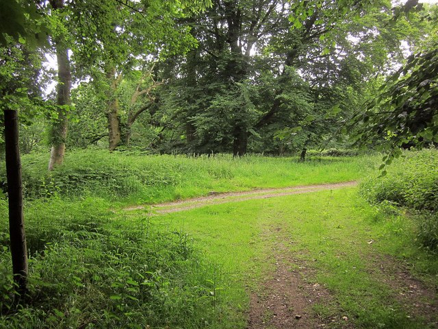
The forest floor is adorned with a carpet of wildflowers, such as bluebells, primroses, and wood anemones, adding bursts of color to the landscape during springtime. The woodland paths wind through the coppice, offering visitors the opportunity to immerse themselves in the tranquil surroundings and enjoy the peaceful ambiance.

Great Cartway Coppice is also home to a small stream that meanders through the woods, adding to the charm and serenity of the area. This stream provides a habitat for various aquatic creatures, including frogs, newts, and small fish.

The coppice is a popular destination for outdoor activities such as walking, birdwatching, and photography. It offers several well-maintained trails that cater to different levels of fitness and interests.

Great Cartway Coppice is a true gem of Wiltshire, offering visitors a chance to connect with nature and explore the beauty of the Downs and Moorland region.

If you have any feedback on the listing, please let us know in the comments section below.

Great Cartway Coppice Images

Images are sourced within 2km of 50.966041/-2.0582775 or Grid Reference ST9618. Thanks to Geograph Open Source API. All images are credited.

Track junction, Chase Woods Staplefoot Road (foreground) meets Longcroft Road (footpath BSJO 19) in Bridmore Green, on the north-western side of the woods.
Track junction, Chase Woods
Staplefoot Road (foreground) meets Longcroft Road (footpath BSJO 19) in Bridmore Green, on the north-western side of the woods.
Longcroft Road Footpath BSJO 19 follows this track through Long Croft in Chase Woods.
Longcroft Road
Footpath BSJO 19 follows this track through Long Croft in Chase Woods.
Chase Avenue Crossing Longcroft Road, which I am following. Chase Avenue is one of a pair of beech avenues created by Augustus Pitt Rivers as an extension to his Rushmore estate in the late C19.
Chase Avenue
Crossing Longcroft Road, which I am following. Chase Avenue is one of a pair of beech avenues created by Augustus Pitt Rivers as an extension to his Rushmore estate in the late C19.
Path, Great Shaftesbury Coppice Approaching the forest edge shown in <a href="https://www.geograph.org.uk/photo/4544846">ST9718 : Little Shaftesbury Coppice</a>.
Path, Great Shaftesbury Coppice
Approaching the forest edge shown in ST9718 : Little Shaftesbury Coppice.
Track by Great Shaftesbury Coppice Bridleway E52 23 runs alongside the edge of Chase Woods. This looks in the other direction from the same spot as <a href="https://www.geograph.org.uk/photo/4544846">ST9718 : Little Shaftesbury Coppice</a>.
Track by Great Shaftesbury Coppice
Bridleway E52 23 runs alongside the edge of Chase Woods. This looks in the other direction from the same spot as ST9718 : Little Shaftesbury Coppice.
Shire Rack The path follows the county boundary between Dorset and Wiltshire.
Shire Rack
The path follows the county boundary between Dorset and Wiltshire.
Parkland east of Oakley Lane Part of Rushmore Park.
Parkland east of Oakley Lane
Part of Rushmore Park.
B3081 looking east Heading towards Sixpenny Handley.
B3081 looking east
Heading towards Sixpenny Handley.
Rushmore Park, avenue The remains of a once fine avenue of beech trees, at the southern entrance to the estate.
Rushmore Park, avenue
The remains of a once fine avenue of beech trees, at the southern entrance to the estate.
Rushmore Park, timber Beech trunks, awaiting collection by the roadside.
Rushmore Park, timber
Beech trunks, awaiting collection by the roadside.
Rushmore Park, footpath Skirting woodland, towards Shermel Gate.
Rushmore Park, footpath
Skirting woodland, towards Shermel Gate.
Rushmore Park, avenue A once fine avenue of beech trees leading from South Lodge. Several have disappeared or are in poor condition.
Rushmore Park, avenue
A once fine avenue of beech trees leading from South Lodge. Several have disappeared or are in poor condition.
Rushmore Park, platform Possibly used for watching equestrian events.
Rushmore Park, platform
Possibly used for watching equestrian events.
Rushmore Park, gate Entering Pollards Wood, on the path to Shermel Gate.
Rushmore Park, gate
Entering Pollards Wood, on the path to Shermel Gate.
Rushmore Park, footpath Through Pollards Wood, on the way to Shermel Gate; part of Hardy Way.
Rushmore Park, footpath
Through Pollards Wood, on the way to Shermel Gate; part of Hardy Way.
Rushmore Park, bluebells Wild bluebells under, unusually, a screen of conifers in Uddens Coppice.
Rushmore Park, bluebells
Wild bluebells under, unusually, a screen of conifers in Uddens Coppice.
Rushmore Park, marker On the path through Uddens Coppice towards Shermel Gate; on Hardy Way.
Rushmore Park, marker
On the path through Uddens Coppice towards Shermel Gate; on Hardy Way.
Rushmore Park, bluebell wood Wild bluebells in Brookes Coppice.
Rushmore Park, bluebell wood
Wild bluebells in Brookes Coppice.
Show me another place!

Great Cartway Coppice is located at Grid Ref: ST9618 (Lat: 50.966041, Lng: -2.0582775)

Unitary Authority: Wiltshire

Police Authority: Wiltshire

What 3 Words

///scream.magazine.thrillers. Near Bower Chalke, Wiltshire

Related Wikis

Woodcutts Settlement

Woodcutts Settlement is an archaeological site of the late Iron Age and Romano-British period on Cranborne Chase, England. It is situated about 1 mile...

Sandroyd School

Sandroyd School is an independent co-educational preparatory school for day and boarding pupils aged 2 to 13 in the south of Wiltshire, England. The school...

Cranborne Chase

Cranborne Chase (grid reference ST970180) is an area of central southern England, straddling the counties Dorset, Hampshire and Wiltshire. It is part of...

South Lodge Camp

South Lodge Camp is an archaeological site of the Bronze Age, about 0.6 miles (1.0 km) south-east of the village of Tollard Royal, in Wiltshire, England...

Cranborne Chase and West Wiltshire Downs

Cranborne Chase and West Wiltshire Downs is an Area of Outstanding Natural Beauty (AONB) covering 379 square miles (980 km2) of Dorset, Hampshire, Somerset...

Rotherley Down Settlement

Rotherley Down Settlement is an archaeological site of the late Iron Age and Romano-British period on Cranborne Chase, England. It is about 1.5 miles...

Tollard Royal

Tollard Royal is a village and civil parish on Cranborne Chase, Wiltshire, England. The parish is on Wiltshire's southern boundary with Dorset and the...

Rotherley Downs

Rotherley Downs (grid reference ST946196) is a 120.05 hectare biological Site of Special Scientific Interest in Wiltshire, England, notified in 1989. The...

Nearby Amenities

Located within 500m of 50.966041,-2.0582775
New Pond Arundell Coppice
Place: locality
Lat/Long: 50.9663976/-2.0548334
Barrow Hill
Place: locality
Lat/Long: 50.9675208/-2.0526966
Little Ball
Place: locality
Lat/Long: 50.9658595/-2.0525913
Badgers Glory
Place: locality
Lat/Long: 50.9652291/-2.053889
Glover's Coppice
Place: locality
Lat/Long: 50.9689416/-2.0544451
The data included in this document is from www.openstreetmap.org. The data is made available under ODbL.

Have you been to Great Cartway Coppice?

Leave your review of Great Cartway Coppice below (or comments, questions and feedback).