Creech Heath

Downs, Moorland in Dorset

England

Creech Heath

Halfway Inn Public house and restaurant on the A531. Located approximately halfway between Wareham and Corfe Castle.
Halfway Inn Credit: Graham Hogg

Creech Heath is a picturesque area located in the county of Dorset, England. Situated within the Cranborne Chase and West Wiltshire Downs Area of Outstanding Natural Beauty, Creech Heath boasts stunning landscapes consisting of downs and moorland.

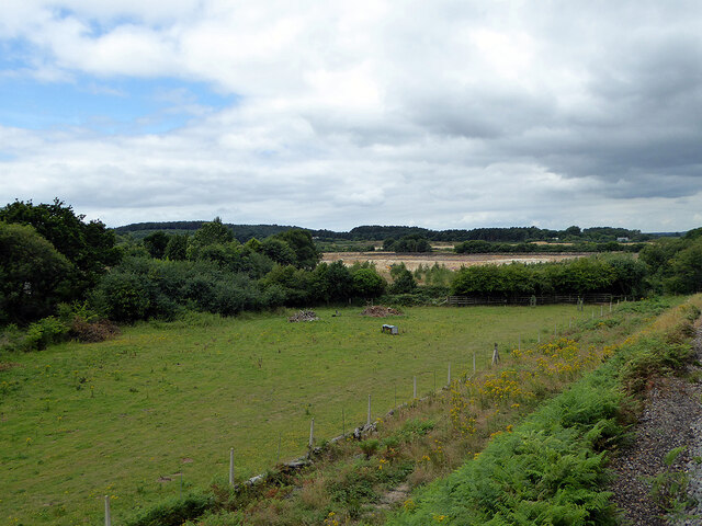
The downs in Creech Heath are characterized by rolling hills and expansive open spaces. These grassy uplands provide a haven for various species of flora and fauna, making it an ideal destination for nature enthusiasts and wildlife lovers. The vibrant colors of wildflowers that adorn the downs during the spring and summer months create a breathtaking sight.

In contrast, the moorland in Creech Heath offers a different kind of beauty. With its heather-covered hills and valleys, the moorland provides a rugged and untamed landscape. Visitors can explore the winding footpaths that meander through this terrain, offering breathtaking views of the surrounding countryside.

Creech Heath is also home to several important archaeological sites, including ancient burial mounds and hill forts. These remnants of the past provide a glimpse into the rich history of the area, attracting history buffs and archaeology enthusiasts.

For those seeking outdoor activities, Creech Heath offers ample opportunities for hiking, cycling, and horseback riding. The well-maintained trails cater to all levels of expertise, allowing visitors to immerse themselves in the natural beauty of the surroundings.

Overall, Creech Heath in Dorset is a haven for nature lovers and history enthusiasts alike. With its stunning downs, rugged moorland, and important archaeological sites, it provides a captivating experience for all who visit.

If you have any feedback on the listing, please let us know in the comments section below.

Creech Heath Images

Images are sourced within 2km of 50.656152/-2.1051973 or Grid Reference SY9284. Thanks to Geograph Open Source API. All images are credited.

Halfway Inn Public house and restaurant on the A531. Located approximately halfway between Wareham and Corfe Castle.
Halfway Inn
Public house and restaurant on the A531. Located approximately halfway between Wareham and Corfe Castle.
Pasture beside the railway Looking towards Stoborough Heath, viewed from a Swanage to Wareham train service.
Pasture beside the railway
Looking towards Stoborough Heath, viewed from a Swanage to Wareham train service.
Old Milestone by the A351, south of Stoborough Green Carved stone post by the A351, in parish of ARNE (PURBECK District), by bus stop and path to Blue Pool, opposite sign 'RVP No 5' at entrance to Hartland Nature reserve, on West side of road. Dorset 2 (limestone), erected by the Wareham (North, South & West Branches) turnpike trust in the 19th century.

Inscription reads:-
II
MILES FROM
WAREHAM
Carved benchmark bottom centre of front face. 

Grade II Listed. List Entry Number:1120342 <span class="nowrap"><a title="https://historicengland.org.uk/listing/the-list/list-entry/1120342" rel="nofollow ugc noopener" href="https://historicengland.org.uk/listing/the-list/list-entry/1120342">Link</a><img style="margin-left:2px;" alt="External link" title="External link - shift click to open in new window" src="https://s1.geograph.org.uk/img/external.png" width="10" height="10"/></span>

Milestone Society National ID: DO_WASW02
Old Milestone by the A351, south of Stoborough Green
Carved stone post by the A351, in parish of ARNE (PURBECK District), by bus stop and path to Blue Pool, opposite sign 'RVP No 5' at entrance to Hartland Nature reserve, on West side of road. Dorset 2 (limestone), erected by the Wareham (North, South & West Branches) turnpike trust in the 19th century. Inscription reads:- II MILES FROM WAREHAM Carved benchmark bottom centre of front face. Grade II Listed. List Entry Number:1120342 LinkExternal link Milestone Society National ID: DO_WASW02
Scrub land beside the railway By Stoborough Heath.
Scrub land beside the railway
By Stoborough Heath.
The Blue Pool, Furzebrook, near Wareham Taken nearly 60 years ago, the location and direction are not precise, although I hope close to the true values.
The Blue Pool, Furzebrook, near Wareham
Taken nearly 60 years ago, the location and direction are not precise, although I hope close to the true values.
Steep road and former quarry below Cocknowle
Hairpin bend below Stonehill Down
Disused quarry face below Stonehill Down The road makes a steep descent with a hairpin bend in the valley to the left.
Disused quarry face below Stonehill Down
The road makes a steep descent with a hairpin bend in the valley to the left.
Rose cottages On the corner of Stoborough Meadow
Rose cottages
On the corner of Stoborough Meadow
Tractor and trailer Outside a house in Stoborough Green
Tractor and trailer
Outside a house in Stoborough Green
Grange Road, King's Barrow A long straight stretch of road close to Stoborough Heath
Grange Road, King's Barrow
A long straight stretch of road close to Stoborough Heath
Railway bridge at Holme Lane Over the Swanage Railway line
Railway bridge at Holme Lane
Over the Swanage Railway line
Furzebrook Public Footpath A view that members of the public are denied, Furzebrook Public Footpath crossing the Swanage Railway. The gradient of 1 in 78 is apparent in this view. Please note I was authorised to be on railway property and hold the appropriate Personal Track Safety qualification.
Furzebrook Public Footpath
A view that members of the public are denied, Furzebrook Public Footpath crossing the Swanage Railway. The gradient of 1 in 78 is apparent in this view. Please note I was authorised to be on railway property and hold the appropriate Personal Track Safety qualification.
On the level? A former Southern Railway concrete Gradient Post indicates the change of grade as the Swanage branch line passes over Blue Pool No.99 Public Footpath.
On the level?
A former Southern Railway concrete Gradient Post indicates the change of grade as the Swanage branch line passes over Blue Pool No.99 Public Footpath.
ClayPit Perhaps I noticed this feature when track walking the Swanage branch and I assume that it is or used to be some sort of clay workings for which the Purbeck area is well known.
ClayPit Perhaps
I noticed this feature when track walking the Swanage branch and I assume that it is or used to be some sort of clay workings for which the Purbeck area is well known.
Telephone box on Grange Road Still has a phone in it!  Here's the proof: <a href="https://www.geograph.org.uk/photo/4948758">SY9182 : Not been used for some time</a>
Telephone box on Grange Road
Still has a phone in it! Here's the proof: SY9182 : Not been used for some time
Pointing the way With one finger post missing (for East Creech) this typical Dorset signpost lies at the junction of Furzebrook Road and the East Creech Road, near East Creech, Isle Of Purbeck, Dorset. The scenery is typical of the area.
Pointing the way
With one finger post missing (for East Creech) this typical Dorset signpost lies at the junction of Furzebrook Road and the East Creech Road, near East Creech, Isle Of Purbeck, Dorset. The scenery is typical of the area.
Show me another place!

Creech Heath is located at Grid Ref: SY9284 (Lat: 50.656152, Lng: -2.1051973)

Unitary Authority: Dorset

Police Authority: Dorset

What 3 Words

///glides.rewrites.servants. Near Wareham, Dorset

Related Wikis

Furzebrook, Dorset

Furzebrook is a small village on the Isle of Purbeck, in the county of Dorset in the south of England. It is about 2 miles (3.2 km) south of Wareham and...

Blue Pool, Dorset

Blue Pool is a flooded, disused clay pit where Purbeck ball clay was once extracted. It is now a lake within the Furzebrook Estate, a 25-acre (10 ha) park...

East Creech

East Creech is a hamlet in the parish of Church Knowle in the county of Dorset, England. East Creech lies at the northern foot of the Purbeck Hills about...

Stoborough Green

Stoborough Green is a village in the English county of Dorset. It is situated to the south of the village of Stoborough and about 2 kilometres south of...

Nearby Amenities

Located within 500m of 50.656152,-2.1051973
Railway: switch
Lat/Long: 50.6572787/-2.0994111
Railway: switch
Lat/Long: 50.6573196/-2.0997878
Railway: switch
Lat/Long: 50.6572689/-2.0992408
Railway: buffer_stop
Lat/Long: 50.6576512/-2.1013888
Railway: switch
Lat/Long: 50.6569796/-2.0983833
Material: wood
Power: pole
Source: bing
Lat/Long: 50.6528367/-2.1006397
Material: wood
Power: pole
Source: bing
Lat/Long: 50.658215/-2.1008063
Material: wood
Power: pole
Source: bing
Lat/Long: 50.6584833/-2.0998568
Material: wood
Power: pole
Source: bing
Lat/Long: 50.654042/-2.0989335
Man Made: wastewater_plant
Source: survey
Lat/Long: 50.6551597/-2.0983254
Fire Flapper
Emergency: fire_flapper
Lat/Long: 50.6559944/-2.1062054
Fire Flapper
Emergency: fire_flapper
Lat/Long: 50.6565466/-2.1103472
Information: board
Source: survey
Tourism: information
Lat/Long: 50.6576923/-2.1110607
Barrier: stile
Source: survey
Lat/Long: 50.6589833/-2.1079292
Railway: crossing
Source: survey
Lat/Long: 50.6590646/-2.1078725
Barrier: stile
Source: survey
Lat/Long: 50.6591083/-2.1078433
Direction: 175
Generator Method: photovoltaic
Generator Output Electricity: yes
Generator Solar Modules: 16
Generator Source: solar
Generator Type: solar_photovoltaic_panel
Location: roof
Power: generator
Lat/Long: 50.6580937/-2.1006251
Ford: yes
Lat/Long: 50.6589873/-2.1016065
The data included in this document is from www.openstreetmap.org. The data is made available under ODbL.

Have you been to Creech Heath?

Leave your review of Creech Heath below (or comments, questions and feedback).