Black Moor

Downs, Moorland in Yorkshire Richmondshire

England

Black Moor

Towards the head of East Gill The view looks over Candleseave Sike just beyond the fenceline towards the gathering ground for what will become East Gill once the former stream joins it in the valley below. Most of the moor this side of East Gill is sedge, which makes for much easier walking than heather despite a lack of paths. Occasionally a set of quad-bike tracks provide a line to follow across the moor, but they follow a gamekeeper's agenda visiting various grouse grit-feeding points, rather than indicating the best line for walkers. They do, however, give a good clue as to the best spot to cross a couple of boggy sections. All in all, this is not a heavily trafficked bit of countryside - I met no-one else until I dropped into the valley bottom of Swaledale (where it became quite crowded) despite this being a pleasant sunny Sunday.
Towards the head of East Gill Credit: Andy Waddington

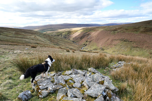
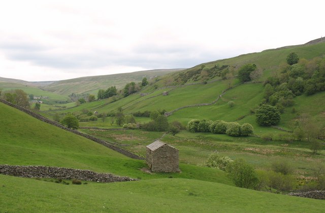
Black Moor is a picturesque and expansive region located in the county of Yorkshire, England. Nestled within the vast expanse of the Yorkshire Downs, this area is renowned for its breathtaking beauty and unique wildlife. Black Moor is characterized by its vast stretches of moorland, which is a type of open, treeless landscape dominated by heather, grasses, and mosses.

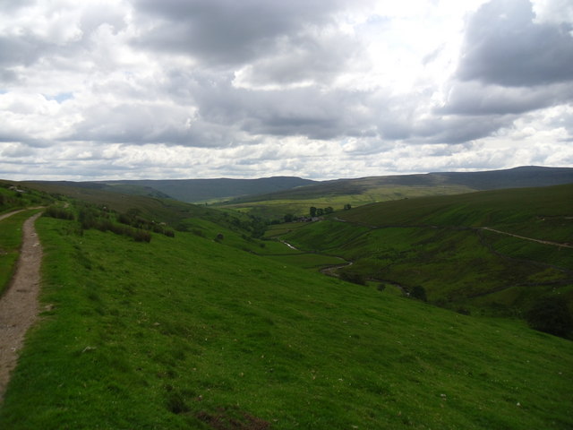
The moorland of Black Moor is a result of centuries of natural processes, with peat bogs forming in the wetter areas. The terrain is undulating, with gentle slopes and occasional rocky outcrops dotting the landscape. This creates a stunning visual contrast, especially during the flowering season when the heather blooms, painting vast expanses of the moor in shades of purple and pink.

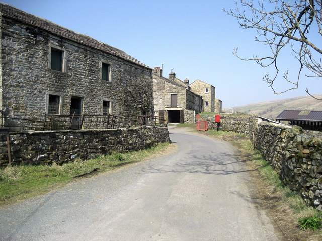
The region is also home to a diverse range of flora and fauna, including various bird species such as lapwings and curlews, which nest in the moorland. The peat bogs provide a unique habitat for specialized plant species such as bog rosemary and cotton grass. In addition, Black Moor is known for its population of hardy sheep, which graze on the rich vegetation.

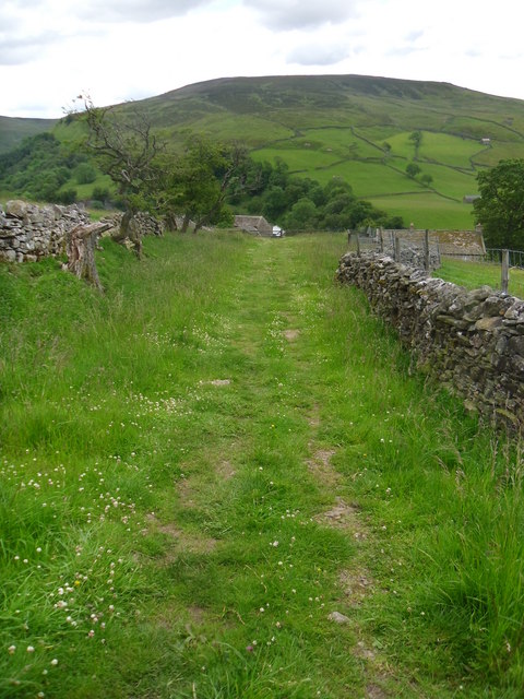
Black Moor offers visitors a serene and tranquil environment, perfect for leisurely walks and hikes. The moorland provides ample opportunities for outdoor activities such as birdwatching, photography, and even horse riding. The surrounding Yorkshire Downs offer stunning panoramic views of the countryside, making it an ideal destination for nature enthusiasts and those seeking a peaceful retreat in the heart of Yorkshire.

If you have any feedback on the listing, please let us know in the comments section below.

Black Moor Images

Images are sourced within 2km of 54.423677/-2.1603141 or Grid Reference NY8903. Thanks to Geograph Open Source API. All images are credited.

Towards the head of East Gill The view looks over Candleseave Sike just beyond the fenceline towards the gathering ground for what will become East Gill once the former stream joins it in the valley below. Most of the moor this side of East Gill is sedge, which makes for much easier walking than heather despite a lack of paths. Occasionally a set of quad-bike tracks provide a line to follow across the moor, but they follow a gamekeeper's agenda visiting various grouse grit-feeding points, rather than indicating the best line for walkers. They do, however, give a good clue as to the best spot to cross a couple of boggy sections. All in all, this is not a heavily trafficked bit of countryside - I met no-one else until I dropped into the valley bottom of Swaledale (where it became quite crowded) despite this being a pleasant sunny Sunday.
Towards the head of East Gill
The view looks over Candleseave Sike just beyond the fenceline towards the gathering ground for what will become East Gill once the former stream joins it in the valley below. Most of the moor this side of East Gill is sedge, which makes for much easier walking than heather despite a lack of paths. Occasionally a set of quad-bike tracks provide a line to follow across the moor, but they follow a gamekeeper's agenda visiting various grouse grit-feeding points, rather than indicating the best line for walkers. They do, however, give a good clue as to the best spot to cross a couple of boggy sections. All in all, this is not a heavily trafficked bit of countryside - I met no-one else until I dropped into the valley bottom of Swaledale (where it became quite crowded) despite this being a pleasant sunny Sunday.
Sheepfold in East Gill Although this sheepfold serves the east side of East Gill, it utilises a loop in the stream to find a spot sheltered from the prevailing westerly weather by the steep eroding bank on the far side. The rocks exposed there are shales of the Stainmore Group of Pendleian age (the earliest substage of the Namurian, Lower Carboniferous) just below the Lower Howgate Edge Grit, above the Crow Chert and corresponding with the Mirk Fell Ganister which occurs somewhat further north and contains quite a bit of coal.
Sheepfold in East Gill
Although this sheepfold serves the east side of East Gill, it utilises a loop in the stream to find a spot sheltered from the prevailing westerly weather by the steep eroding bank on the far side. The rocks exposed there are shales of the Stainmore Group of Pendleian age (the earliest substage of the Namurian, Lower Carboniferous) just below the Lower Howgate Edge Grit, above the Crow Chert and corresponding with the Mirk Fell Ganister which occurs somewhat further north and contains quite a bit of coal.
East Gill from south of Long Gill The rather indistinct and intermittent quad bike tracks that form the only guide to the easiest route on the east bank of East Gill have just made a rather precarious and boggy crossing of Long Gill and ascended back onto firm ground. This pile of stones (it hardly qualifies as a cairn) commands a view over East Gill as it cuts down on its way to join the River Swale down a series of waterfalls into the Keld Gorge.
East Gill from south of Long Gill
The rather indistinct and intermittent quad bike tracks that form the only guide to the easiest route on the east bank of East Gill have just made a rather precarious and boggy crossing of Long Gill and ascended back onto firm ground. This pile of stones (it hardly qualifies as a cairn) commands a view over East Gill as it cuts down on its way to join the River Swale down a series of waterfalls into the Keld Gorge.
Sheepfold by East Gill Walking back to Keld from Rogan's Seat.
Sheepfold by East Gill
Walking back to Keld from Rogan's Seat.
Fellside wall below Garland Hills Lovely Seat dominates the backdrop.
Fellside wall below Garland Hills
Lovely Seat dominates the backdrop.
Goods wagon, West Stones Dale The wagon appears in good condition and seems to be secure.
Goods wagon, West Stones Dale
The wagon appears in good condition and seems to be secure.
Bridleway, West Stones Dale The bridleway crosses open moorland and it will soon join the Pennine Way.
Bridleway, West Stones Dale
The bridleway crosses open moorland and it will soon join the Pennine Way.
Barns and walls, West Stonesdale The beautiful stone built barns so typical of the dales.
Barns and walls, West Stonesdale
The beautiful stone built barns so typical of the dales.
Wriggly track near Keld The track wriggles its way down the hill and up the other side.
Wriggly track near Keld
The track wriggles its way down the hill and up the other side.
Track, Stonesdale The track acts as a bridleway which takes riders and walkers to join the Pennine Way.
Track, Stonesdale
The track acts as a bridleway which takes riders and walkers to join the Pennine Way.
Fields and barns in Stonesdale The fields are bound with drystone walls.

Drystone walls are built without mortar, and their stability – they can stand for 200 years – is due to the skill of the craftsmen who place rough boulders and angular stones together.

Many drystone walls were constructed as part of the enclosure of open grazing. They were especially useful in areas too exposed for hedgerows to survive and where stones were readily available.

Most drystone walls are wider at the base than at the crown, and are often capped with coping stones. A typical wall has two outer layers of large, flattish stones enclosing an inner ‘heart’ of smaller, rounder stones. Often it is reinforced with ‘through bands’ of even larger, flat stones which can also be used as stiles.

The very dryness of a wall makes it more likely to endure wind and frost and to act as shelter for livestock as well as a boundary.
Fields and barns in Stonesdale
The fields are bound with drystone walls. Drystone walls are built without mortar, and their stability – they can stand for 200 years – is due to the skill of the craftsmen who place rough boulders and angular stones together. Many drystone walls were constructed as part of the enclosure of open grazing. They were especially useful in areas too exposed for hedgerows to survive and where stones were readily available. Most drystone walls are wider at the base than at the crown, and are often capped with coping stones. A typical wall has two outer layers of large, flattish stones enclosing an inner ‘heart’ of smaller, rounder stones. Often it is reinforced with ‘through bands’ of even larger, flat stones which can also be used as stiles. The very dryness of a wall makes it more likely to endure wind and frost and to act as shelter for livestock as well as a boundary.
Pennine way. Looking back towards Keld.
Pennine way.
Looking back towards Keld.
Pennine way. Looking south along path.
Pennine way.
Looking south along path.
The track to Frith lodge. A very windy /steep track.
The track to Frith lodge.
A very windy /steep track.
Shelter and sheep on Stonesdale Moor
Startindale Gill A gill in West Stonesdale.
Startindale Gill
A gill in West Stonesdale.
Currack Force The edge of Rainby Force is just in view on the left.
Currack Force
The edge of Rainby Force is just in view on the left.
Hoggarts Leap - The Rapid The Upper Swale is a river for kayakers wanting to run waterfalls. Hoggarts Leap (named on the large scale OS map) doesn't really qualify and is consequently universally known to paddlers simply as "The Rapid". There's a wide choice of possible lines, some get easier as the water gets higher, others get harder. The confident tend to take the shelf river right, and boof into the current as far forward as the water allows, then paddle a sneak line hard right, or cross to the photographer's side. There's a big kicker in the middle which most tend to try to avoid. The kayaker seen here (your photographer's other half) has taken a more conservative (but some would think more difficult) line down the corner seam, then across the stopper to reach river left, where she is now nicely on line for the second bouncy drop. Either of these routes works at this level - 0.96m on the Park Bridge gauge passed just a few minutes earlier, though the level was coming up as we paddled. For those who came only for the waterfalls and don't fancy more complex water, it's an easy portage river left.
Hoggarts Leap - The Rapid
The Upper Swale is a river for kayakers wanting to run waterfalls. Hoggarts Leap (named on the large scale OS map) doesn't really qualify and is consequently universally known to paddlers simply as "The Rapid". There's a wide choice of possible lines, some get easier as the water gets higher, others get harder. The confident tend to take the shelf river right, and boof into the current as far forward as the water allows, then paddle a sneak line hard right, or cross to the photographer's side. There's a big kicker in the middle which most tend to try to avoid. The kayaker seen here (your photographer's other half) has taken a more conservative (but some would think more difficult) line down the corner seam, then across the stopper to reach river left, where she is now nicely on line for the second bouncy drop. Either of these routes works at this level - 0.96m on the Park Bridge gauge passed just a few minutes earlier, though the level was coming up as we paddled. For those who came only for the waterfalls and don't fancy more complex water, it's an easy portage river left.
Show me another place!

Black Moor is located at Grid Ref: NY8903 (Lat: 54.423677, Lng: -2.1603141)

Division: North Riding

Administrative County: North Yorkshire

District: Richmondshire

Police Authority: North Yorkshire

What 3 Words

///revise.community.look. Near Kirkby Stephen, Cumbria

Related Wikis

West Stonesdale

West Stonesdale is a hamlet in the Yorkshire Dales, North Yorkshire, England. The secluded village is near Keld to the south, Tan Hill to the north and...

East Gill Force

East Gill Force is a waterfall in Swaledale, 330 yards (300 m) east of the hamlet of Keld, in the Yorkshire Dales National Park, North Yorkshire, England...

Keld, North Yorkshire

Keld is a village in the English county of North Yorkshire. It is in Swaledale, and the Yorkshire Dales National Park. The name derives from the Viking...

Wain Wath Force

Wain Wath Force is a waterfall on the River Swale in the Yorkshire Dales National Park, North Yorkshire, England. The falls are at grid reference NY883015...

Kisdon Force

Kisdon Force is a series of waterfalls on the River Swale in Swaledale, England. The falls are situated within the Yorkshire Dales National Park in the...

Rogan's Seat

Rogan's Seat is a remote hill located near East Stonesdale and Gunnerside Gill, in the Yorkshire Dales in England. It is a high expanse of moorland that...

Catrake Force

Catrake Force is a waterfall on the River Swale in North Yorkshire, England. It is not visible from the road but is accessible via a campsite in Keld....

Angram Bottoms

Angram Bottoms (grid reference SD891999) is a 9.8 hectares (24 acres) biological Site of Special Scientific Interest (SSSI) near to the village of Angram...

Related Videos

Coast to Coast: Solo Hiking Across the Country - Day 8 (4K)

Join me on Patreon! https://www.patreon.com/TinyPineOutdoors Day 8 of solo hiking the Coast to Coast, my mum dropped me off ...

Hiking John O’ Groats to Land’s End | Daily Vlog | Day 33

Me and Di (my girlfriend) are hiking from John O' Groats to Land's End and wild camping all the way. This is a daily vlog of our ...

Pennine Way (part 7) - Tann Hill pub, trail magic & walking in the clouds

Another beautiful part of the Pennine Way hike between Horton and Middleton-in-Teasdale. With a few steep climbs and rocky ...

Have you been to Black Moor?

Leave your review of Black Moor below (or comments, questions and feedback).