Coalpit Hill

Hill, Mountain in Yorkshire Richmondshire

England

Coalpit Hill

Towards the head of East Gill The view looks over Candleseave Sike just beyond the fenceline towards the gathering ground for what will become East Gill once the former stream joins it in the valley below. Most of the moor this side of East Gill is sedge, which makes for much easier walking than heather despite a lack of paths. Occasionally a set of quad-bike tracks provide a line to follow across the moor, but they follow a gamekeeper's agenda visiting various grouse grit-feeding points, rather than indicating the best line for walkers. They do, however, give a good clue as to the best spot to cross a couple of boggy sections. All in all, this is not a heavily trafficked bit of countryside - I met no-one else until I dropped into the valley bottom of Swaledale (where it became quite crowded) despite this being a pleasant sunny Sunday.
Towards the head of East Gill Credit: Andy Waddington

Coalpit Hill is a prominent geological formation located in Yorkshire, England. Situated in the eastern part of the county, it is part of the Pennine range, known for its rugged and picturesque landscapes. Rising to an elevation of approximately 413 meters (1,355 feet) above sea level, Coalpit Hill is often classified as a hill rather than a mountain due to its relatively modest height.

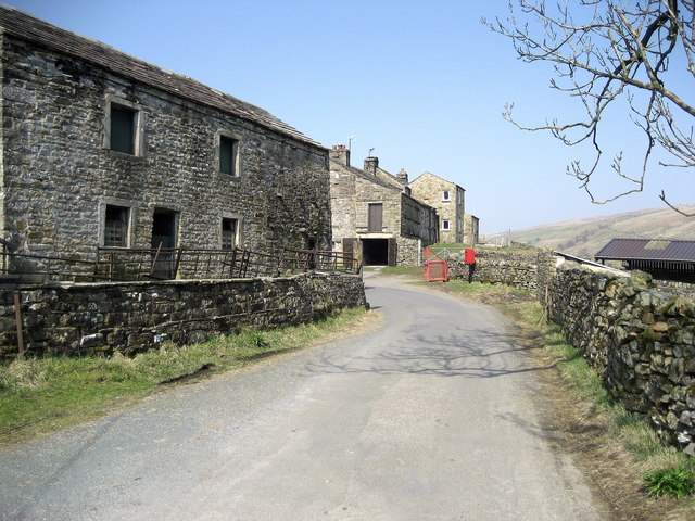
The hill takes its name from the coal mining activity that once thrived in the surrounding area. During the 18th and 19th centuries, numerous coal pits were established in the vicinity, making Coalpit Hill a significant site for the local mining industry.

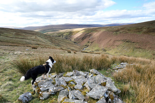
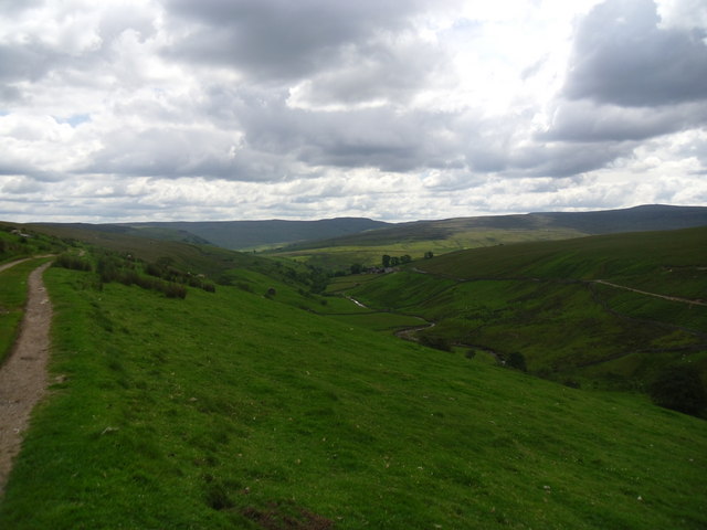
Today, Coalpit Hill is known for its natural beauty and offers breathtaking panoramic views of the Yorkshire countryside. The hill is covered in lush greenery, with heather and grasses adorning its slopes. It is a popular destination for outdoor enthusiasts, including hikers and nature lovers, who are drawn to its tranquil environment and the opportunity to explore the surrounding trails and footpaths.

The summit of Coalpit Hill provides visitors with an unforgettable vista, overlooking the picturesque villages and rolling hills of Yorkshire. On a clear day, it is even possible to catch a glimpse of the distant Yorkshire Dales National Park to the west.

Coalpit Hill is not only a natural landmark but also serves as a reminder of the region's industrial heritage. Its historical significance, combined with its stunning landscapes, makes it a compelling destination for both locals and tourists alike.

If you have any feedback on the listing, please let us know in the comments section below.

Coalpit Hill Images

Images are sourced within 2km of 54.427755/-2.1619484 or Grid Reference NY8903. Thanks to Geograph Open Source API. All images are credited.

Towards the head of East Gill The view looks over Candleseave Sike just beyond the fenceline towards the gathering ground for what will become East Gill once the former stream joins it in the valley below. Most of the moor this side of East Gill is sedge, which makes for much easier walking than heather despite a lack of paths. Occasionally a set of quad-bike tracks provide a line to follow across the moor, but they follow a gamekeeper's agenda visiting various grouse grit-feeding points, rather than indicating the best line for walkers. They do, however, give a good clue as to the best spot to cross a couple of boggy sections. All in all, this is not a heavily trafficked bit of countryside - I met no-one else until I dropped into the valley bottom of Swaledale (where it became quite crowded) despite this being a pleasant sunny Sunday.
Towards the head of East Gill
The view looks over Candleseave Sike just beyond the fenceline towards the gathering ground for what will become East Gill once the former stream joins it in the valley below. Most of the moor this side of East Gill is sedge, which makes for much easier walking than heather despite a lack of paths. Occasionally a set of quad-bike tracks provide a line to follow across the moor, but they follow a gamekeeper's agenda visiting various grouse grit-feeding points, rather than indicating the best line for walkers. They do, however, give a good clue as to the best spot to cross a couple of boggy sections. All in all, this is not a heavily trafficked bit of countryside - I met no-one else until I dropped into the valley bottom of Swaledale (where it became quite crowded) despite this being a pleasant sunny Sunday.
Sheepfold in East Gill Although this sheepfold serves the east side of East Gill, it utilises a loop in the stream to find a spot sheltered from the prevailing westerly weather by the steep eroding bank on the far side. The rocks exposed there are shales of the Stainmore Group of Pendleian age (the earliest substage of the Namurian, Lower Carboniferous) just below the Lower Howgate Edge Grit, above the Crow Chert and corresponding with the Mirk Fell Ganister which occurs somewhat further north and contains quite a bit of coal.
Sheepfold in East Gill
Although this sheepfold serves the east side of East Gill, it utilises a loop in the stream to find a spot sheltered from the prevailing westerly weather by the steep eroding bank on the far side. The rocks exposed there are shales of the Stainmore Group of Pendleian age (the earliest substage of the Namurian, Lower Carboniferous) just below the Lower Howgate Edge Grit, above the Crow Chert and corresponding with the Mirk Fell Ganister which occurs somewhat further north and contains quite a bit of coal.
East Gill from south of Long Gill The rather indistinct and intermittent quad bike tracks that form the only guide to the easiest route on the east bank of East Gill have just made a rather precarious and boggy crossing of Long Gill and ascended back onto firm ground. This pile of stones (it hardly qualifies as a cairn) commands a view over East Gill as it cuts down on its way to join the River Swale down a series of waterfalls into the Keld Gorge.
East Gill from south of Long Gill
The rather indistinct and intermittent quad bike tracks that form the only guide to the easiest route on the east bank of East Gill have just made a rather precarious and boggy crossing of Long Gill and ascended back onto firm ground. This pile of stones (it hardly qualifies as a cairn) commands a view over East Gill as it cuts down on its way to join the River Swale down a series of waterfalls into the Keld Gorge.
Sheepfold by East Gill Walking back to Keld from Rogan's Seat.
Sheepfold by East Gill
Walking back to Keld from Rogan's Seat.
Fellside wall below Garland Hills Lovely Seat dominates the backdrop.
Fellside wall below Garland Hills
Lovely Seat dominates the backdrop.
Goods wagon, West Stones Dale The wagon appears in good condition and seems to be secure.
Goods wagon, West Stones Dale
The wagon appears in good condition and seems to be secure.
Bridleway, West Stones Dale The bridleway crosses open moorland and it will soon join the Pennine Way.
Bridleway, West Stones Dale
The bridleway crosses open moorland and it will soon join the Pennine Way.
Barns and walls, West Stonesdale The beautiful stone built barns so typical of the dales.
Barns and walls, West Stonesdale
The beautiful stone built barns so typical of the dales.
Wriggly track near Keld The track wriggles its way down the hill and up the other side.
Wriggly track near Keld
The track wriggles its way down the hill and up the other side.
Track, Stonesdale The track acts as a bridleway which takes riders and walkers to join the Pennine Way.
Track, Stonesdale
The track acts as a bridleway which takes riders and walkers to join the Pennine Way.
Fields and barns in Stonesdale The fields are bound with drystone walls.

Drystone walls are built without mortar, and their stability – they can stand for 200 years – is due to the skill of the craftsmen who place rough boulders and angular stones together.

Many drystone walls were constructed as part of the enclosure of open grazing. They were especially useful in areas too exposed for hedgerows to survive and where stones were readily available.

Most drystone walls are wider at the base than at the crown, and are often capped with coping stones. A typical wall has two outer layers of large, flattish stones enclosing an inner ‘heart’ of smaller, rounder stones. Often it is reinforced with ‘through bands’ of even larger, flat stones which can also be used as stiles.

The very dryness of a wall makes it more likely to endure wind and frost and to act as shelter for livestock as well as a boundary.
Fields and barns in Stonesdale
The fields are bound with drystone walls. Drystone walls are built without mortar, and their stability – they can stand for 200 years – is due to the skill of the craftsmen who place rough boulders and angular stones together. Many drystone walls were constructed as part of the enclosure of open grazing. They were especially useful in areas too exposed for hedgerows to survive and where stones were readily available. Most drystone walls are wider at the base than at the crown, and are often capped with coping stones. A typical wall has two outer layers of large, flattish stones enclosing an inner ‘heart’ of smaller, rounder stones. Often it is reinforced with ‘through bands’ of even larger, flat stones which can also be used as stiles. The very dryness of a wall makes it more likely to endure wind and frost and to act as shelter for livestock as well as a boundary.
Pennine way. Looking south along path.
Pennine way.
Looking south along path.
The track to Frith lodge. A very windy /steep track.
The track to Frith lodge.
A very windy /steep track.
Shelter and sheep on Stonesdale Moor
Startindale Gill A gill in West Stonesdale.
Startindale Gill
A gill in West Stonesdale.
Track to Firth Lodge Looking across Startindale Gill.
Track to Firth Lodge
Looking across Startindale Gill.
Startindale Gill
Startindale Gill
West Stones Dale Looking north with Stonesdale Beck in the valley to the right of the road.
West Stones Dale
Looking north with Stonesdale Beck in the valley to the right of the road.
Show me another place!

Coalpit Hill is located at Grid Ref: NY8903 (Lat: 54.427755, Lng: -2.1619484)

Division: North Riding

Administrative County: North Yorkshire

District: Richmondshire

Police Authority: North Yorkshire

What 3 Words

///refilled.convinced.holidays. Near Kirkby Stephen, Cumbria

Related Wikis

West Stonesdale

West Stonesdale is a hamlet in the Yorkshire Dales, North Yorkshire, England. The secluded village is near Keld to the south, Tan Hill to the north and...

Rogan's Seat

Rogan's Seat is a remote hill located near East Stonesdale and Gunnerside Gill, in the Yorkshire Dales in England. It is a high expanse of moorland that...

East Gill Force

East Gill Force is a waterfall in Swaledale, 330 yards (300 m) east of the hamlet of Keld, in the Yorkshire Dales National Park, North Yorkshire, England...

Wain Wath Force

Wain Wath Force is a waterfall on the River Swale in the Yorkshire Dales National Park, North Yorkshire, England. The falls are at grid reference NY883015...

Keld, North Yorkshire

Keld is a village in the English county of North Yorkshire. It is in Swaledale, and the Yorkshire Dales National Park. The name derives from the Viking...

Kisdon Force

Kisdon Force is a series of waterfalls on the River Swale in Swaledale, England. The falls are situated within the Yorkshire Dales National Park in the...

Catrake Force

Catrake Force is a waterfall on the River Swale in North Yorkshire, England. It is not visible from the road but is accessible via a campsite in Keld....

Tan Hill, North Yorkshire

Tan Hill (NY896067) is a high point on the Pennine Way in the Richmondshire district of North Yorkshire, England. It lies north of Keld in the civil parish...

Have you been to Coalpit Hill?

Leave your review of Coalpit Hill below (or comments, questions and feedback).