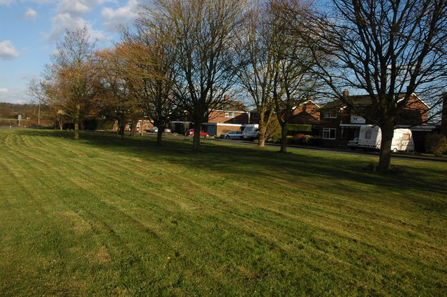
Dunstall Common

Downs, Moorland in Worcestershire Malvern Hills

England

Dunstall Common

Earl's Croome church Earl's Croome church is dedicated to St Nicholas.  The church is Grade II* listed, see: <span class="nowrap"><a title="https://historicengland.org.uk/listing/the-list/list-entry/1302545?section=comments-and-photos" rel="nofollow ugc noopener" href="https://historicengland.org.uk/listing/the-list/list-entry/1302545?section=comments-and-photos">Link</a><img style="margin-left:2px;" alt="External link" title="External link - shift click to open in new window" src="https://s1.geograph.org.uk/img/external.png" width="10" height="10"/></span>
Earl's Croome church Credit: Philip Halling

Dunstall Common is a picturesque area located in Worcestershire, England. Spanning over several acres, it is a beautiful expanse of downs and moorland that offers a stunning natural landscape. The common is characterized by its rolling hills, open fields, and scattered patches of trees.

The common is a haven for nature enthusiasts and outdoor lovers. It is home to a diverse range of flora and fauna, with various species of wildflowers, grasses, and shrubs dotting the landscape. The area is particularly known for its heather, which blooms in vibrant shades of purple during late summer.

The common is also a popular spot for birdwatchers, as it attracts a wide variety of bird species. Visitors can spot various birds of prey, such as kestrels and buzzards, soaring high in the sky. Additionally, the common is a habitat for smaller birds like larks, finches, and warblers.

Walking trails crisscross the common, allowing visitors to explore its natural beauty at their own pace. These paths offer breathtaking views of the surrounding Worcestershire countryside, with glimpses of distant hills and valleys. The common is also intersected by a small stream, adding to its charm and providing a tranquil atmosphere.

Dunstall Common is not only a haven for wildlife and nature lovers, but it also holds historical significance. The area has evidence of prehistoric settlements, including ancient burial mounds and earthworks. These historical remnants add an extra layer of intrigue to the common, making it an enticing destination for those interested in local history.

Overall, Dunstall Common in Worcestershire offers a captivating blend of natural beauty, wildlife, and historical significance. Whether you are seeking a peaceful walk, birdwatching opportunities, or a glimpse into the past, this common is a must-visit destination.

If you have any feedback on the listing, please let us know in the comments section below.

Dunstall Common Images

Images are sourced within 2km of 52.084648/-2.1680439 or Grid Reference SO8842. Thanks to Geograph Open Source API. All images are credited.

Earl's Croome church Earl's Croome church is dedicated to St Nicholas.  The church is Grade II* listed, see: <span class="nowrap"><a title="https://historicengland.org.uk/listing/the-list/list-entry/1302545?section=comments-and-photos" rel="nofollow ugc noopener" href="https://historicengland.org.uk/listing/the-list/list-entry/1302545?section=comments-and-photos">Link</a><img style="margin-left:2px;" alt="External link" title="External link - shift click to open in new window" src="https://s1.geograph.org.uk/img/external.png" width="10" height="10"/></span>
Earl's Croome church
Earl's Croome church is dedicated to St Nicholas. The church is Grade II* listed, see: LinkExternal link
Seat at the end of the landing strip At the west end of the light aircraft landing strip is a seat with a view across flat farmland to the Malvern Hills.
Seat at the end of the landing strip
At the west end of the light aircraft landing strip is a seat with a view across flat farmland to the Malvern Hills.
Landing strip near Woodmancote View east from the end of the grass runway. The large barns serving as hangars are beyond the oilseed rape crop on the right. 
See <a href="https://www.geograph.org.uk/photo/2446965">SO9143 : Landing strip near Woodmancote</a> for the other end of the strip.
Landing strip near Woodmancote
View east from the end of the grass runway. The large barns serving as hangars are beyond the oilseed rape crop on the right. See SO9143 : Landing strip near Woodmancote for the other end of the strip.
Into the sunset A car heads west towards Upton on the A4104 at Woodmancote.
Into the sunset
A car heads west towards Upton on the A4104 at Woodmancote.
Footpath to Woodmancote Brake Looking south from the A4104.
Footpath to Woodmancote Brake
Looking south from the A4104.
Bourne Brook near Woodmancote The satellite station in the background is situated on the former Defford Airfield.
Bourne Brook near Woodmancote
The satellite station in the background is situated on the former Defford Airfield.
Golf Balls at Defford Golf Balls on the site of the former Defford Airfield. The airfield was opened in 1941 during the Second World War and played a significant role in the development of Radar. Since the war the site has remained a satellite station. The site is clearly visible from the passing Bristol to Birmingham railway line.
Golf Balls at Defford
Golf Balls on the site of the former Defford Airfield. The airfield was opened in 1941 during the Second World War and played a significant role in the development of Radar. Since the war the site has remained a satellite station. The site is clearly visible from the passing Bristol to Birmingham railway line.
Woodmancote Brake The triangular shaped wood to the left is Woodmancote Brake. The course of Bourne Brook can be seen meandering across the land.
Woodmancote Brake
The triangular shaped wood to the left is Woodmancote Brake. The course of Bourne Brook can be seen meandering across the land.
Trailer and silage bales A trailer and silage bales beside the A4104 between Baughton and Defford. The disused Defford airfield is in the background, now the site of a satellite station.
Trailer and silage bales
A trailer and silage bales beside the A4104 between Baughton and Defford. The disused Defford airfield is in the background, now the site of a satellite station.
Swans on Bourne Brook Two swans on Bourne Brook, in the distance is Defford Satellite station.
Swans on Bourne Brook
Two swans on Bourne Brook, in the distance is Defford Satellite station.
The A4104 near Woodmancote The A4104 pictured to the west of Woodmancote, Bredon Hill is in the background.
The A4104 near Woodmancote
The A4104 pictured to the west of Woodmancote, Bredon Hill is in the background.
The site of RAF Defford Airfield The former RAF Defford Airfield which was constructed in 1941 and became important in the development of RADAR.  The airfield closed in 1957.  The land is now farmed and West Mercia Constabulary occupy part of the site as well as a satellite communications facility.  Planning has been given for the installation of 120,000 solar panels, the equivalent of 60 football pitches.
The site of RAF Defford Airfield
The former RAF Defford Airfield which was constructed in 1941 and became important in the development of RADAR. The airfield closed in 1957. The land is now farmed and West Mercia Constabulary occupy part of the site as well as a satellite communications facility. Planning has been given for the installation of 120,000 solar panels, the equivalent of 60 football pitches.
Buildings on former RAF Defford The former RAF Defford Airfield which was constructed in 1941 and became important in the development of RADAR.  The airfield closed in 1957.  The land is now farmed and West Mercia Constabulary occupy part of the site.  There is also a satellite communications facility.  Planning has been given for the installation of 120,000 solar panels, the equivalent of 60 football pitches.
Buildings on former RAF Defford
The former RAF Defford Airfield which was constructed in 1941 and became important in the development of RADAR. The airfield closed in 1957. The land is now farmed and West Mercia Constabulary occupy part of the site. There is also a satellite communications facility. Planning has been given for the installation of 120,000 solar panels, the equivalent of 60 football pitches.
A4104 near Woodmancote With the Malvern Hills in the distance.
A4104 near Woodmancote
With the Malvern Hills in the distance.
Old Milestone by the A4104, Woodmancote Stone post (plate lost) by the A4104, in parish of Defford (Wychavon District), 200m West of Woodmancote Farm (the Monkey House), in hedge opposite road sign, on South side of road. Erected by the Evesham Second District turnpike trust in the 19th century. 

Inscription once read:-
(Upton upon Severn)
(4)
(Pershore)
(4)    
Rivet benchmark on top.

Milestone Society National ID: WO_PSUS04
Old Milestone by the A4104, Woodmancote
Stone post (plate lost) by the A4104, in parish of Defford (Wychavon District), 200m West of Woodmancote Farm (the Monkey House), in hedge opposite road sign, on South side of road. Erected by the Evesham Second District turnpike trust in the 19th century. Inscription once read:- (Upton upon Severn) (4) (Pershore) (4) Rivet benchmark on top. Milestone Society National ID: WO_PSUS04
Milestone, Woodmancote Stone post (plate lost) by the A4104, in parish of Defford (Wychavon District), 200m W of Woodmancote Farm (the Monkey House), in hedge opposite road sign, on South side of road.  Erected by the Evesham Second District Turnpike Trust in the 19th century. 
The inscription once showed mileages to Pershore, 4, and Upton, 4. 
Not listed by Historic England. NGR: SO 90315 42540

Milestone Society National ID: WO_PSUS04
Milestone, Woodmancote
Stone post (plate lost) by the A4104, in parish of Defford (Wychavon District), 200m W of Woodmancote Farm (the Monkey House), in hedge opposite road sign, on South side of road. Erected by the Evesham Second District Turnpike Trust in the 19th century. The inscription once showed mileages to Pershore, 4, and Upton, 4. Not listed by Historic England. NGR: SO 90315 42540 Milestone Society National ID: WO_PSUS04
The Cider House at Woodmancote The Cider House at Woodmancote, also known as the Monkey House because many years ago a customer came to the bar claiming he'd been attacked by monkeys.  Maybe he'd had one too many.  The cider house used to serve cider made from apples from an orchard behind the house.
The Cider House at Woodmancote
The Cider House at Woodmancote, also known as the Monkey House because many years ago a customer came to the bar claiming he'd been attacked by monkeys. Maybe he'd had one too many. The cider house used to serve cider made from apples from an orchard behind the house.
Footpath off the A4104, Woodmancote
Show me another place!

Dunstall Common is located at Grid Ref: SO8842 (Lat: 52.084648, Lng: -2.1680439)

Administrative County: Worcestershire

District: Malvern Hills

Police Authority: West Mercia

What 3 Words

///piled.massaging.given. Near Eckington, Worcestershire

Related Wikis

Dunstall Common

Dunstall Common is a village in Worcestershire, England.

Baughton

Baughton is a hamlet in Worcestershire, England. The Population of Baughton is 193. The population as a whole is older than the national average and the...
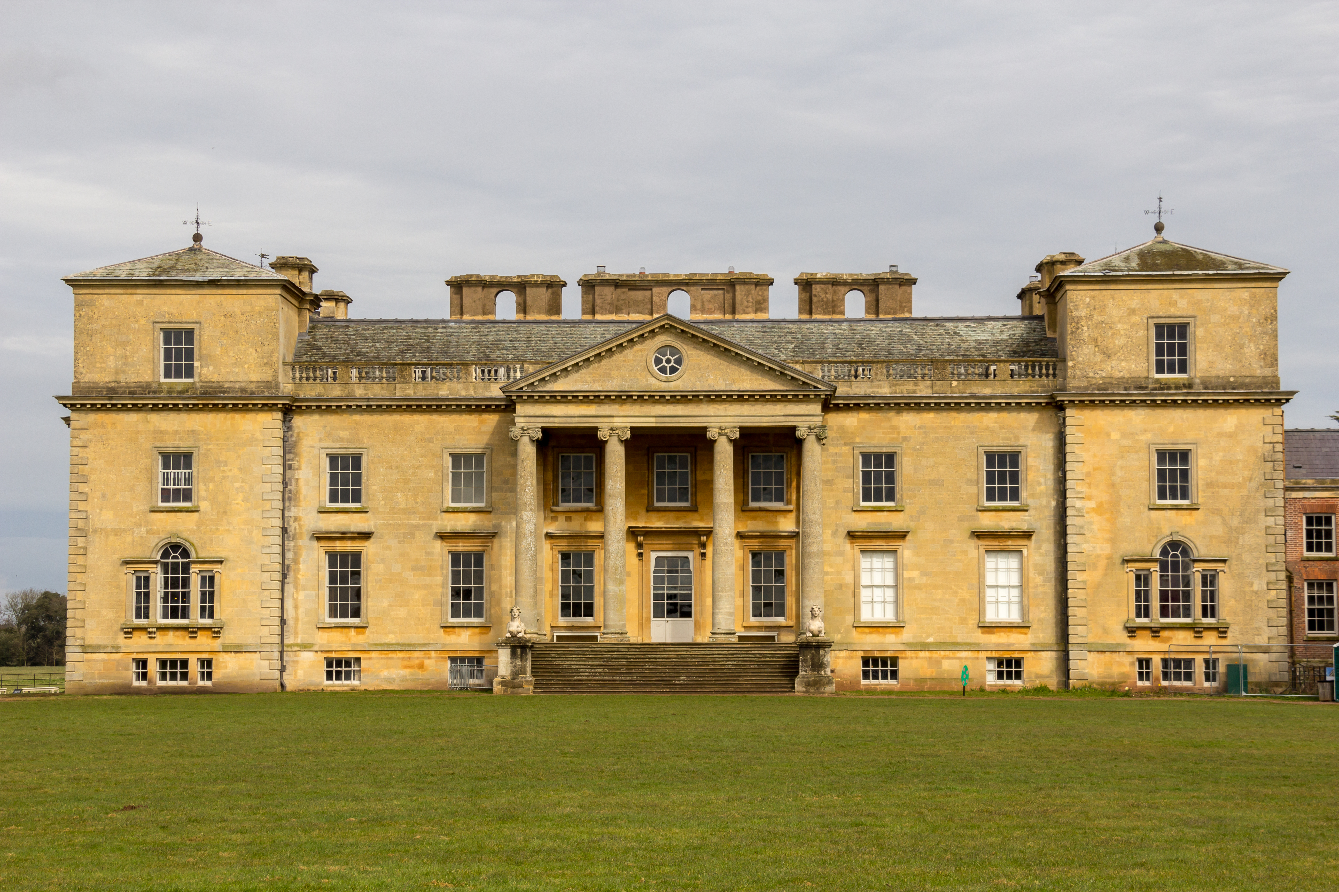
Croome Court

Croome Court is a mid-18th-century Neo-Palladian mansion surrounded by extensive landscaped parkland at Croome D'Abitot, near Upton-upon-Severn in south...

Horewell Forest

Horewell Forest was a royal forest, i. e. a royal game preserve. In the west, it bordered the river Severn, and Strensham in the south and extended to...

Earls Croome

Earl's Croome is a village and civil parish in the Malvern Hills District in the county of Worcestershire, England. It had a population of 243 in 2021...

Croome D'Abitot

Croome D'Abitot is a village and civil parish, which shares a joint parish council with Severn Stoke, in the Malvern Hills District in the county of Worcestershire...

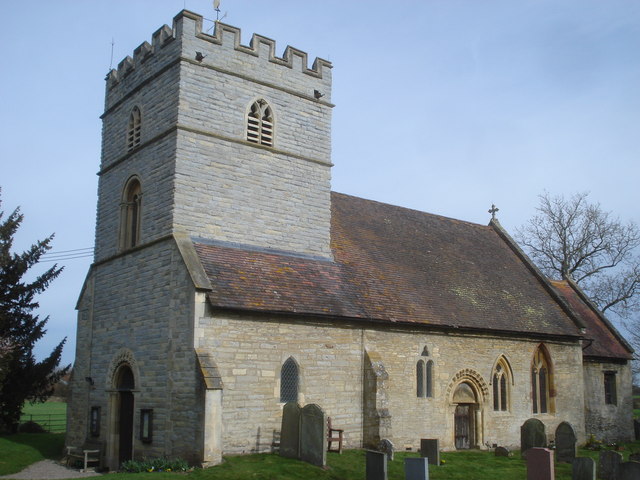
St Mary Magdalene's Church, Croome D'Abitot

St Mary Magdalene's Church is a former Anglican church in the grounds of Croome Court, at Croome D'Abitot, Worcestershire, England. It is recorded in...

RAF Defford

Royal Air Force Defford, or more simply RAF Defford, is a former Royal Air Force station located 1.1 miles (1.8 km) northwest of Defford, Worcestershire...

Related Videos

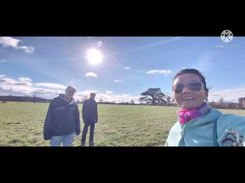
NATIONAL TRUST - CROOME - 4K DJI MINI 3 PRO DRONE & WALKING TOUR 2023

Well back up in the sky over National Trust Croome with my DJI Mini 3 Pro Drone in 4K , Walking footage taken on the iPhone 14 ...

Croome Court walking around

Walking around croome Court.

A days walking around Croome National Trust @nationaltrustcharity

A lovely walk round National Trust Croome #disneyprep.

Nearby Amenities

Located within 500m of 52.084648,-2.1680439
Dunstall Common
Naptan AtcoCode: 2000G643002
Naptan Bearing: NE
Naptan BusStopType: CUS
Naptan CommonName: Dunstall Common
Naptan Indicator: adj
Naptan Landmark: near Chequers
Naptan NaptanCode: wocdmamg
Naptan Street: Dunstall Common
Naptan Verified: no
Source: naptan_import
Lat/Long: 52.084532/-2.1737272
Phone
Check Date: 2022-03-22
Emergency: phone
Source: survey
Lat/Long: 52.084169/-2.1752321
Post Box
Collection Times: Mo-Fr 16:00; Sa 07:15
Post Box Type: lamp
Ref: WR8 129
Royal Cypher: EIIR
Royal Cypher Wikidata: Q33102113
Source: GPS Survey
Lat/Long: 52.0844872/-2.1708506
Barrier: stile
Foot: yes
Lat/Long: 52.085257/-2.1621524
Barrier: stile
Foot: yes
Lat/Long: 52.086948/-2.1623154
Red Deer Park Farm
Power: pole
Transformer: distribution
Voltage Primary: 11000
Lat/Long: 52.0843191/-2.1607742
Dunstall Farm Severn Stoke
Power: pole
Transformer: distribution
Lat/Long: 52.0871259/-2.1661051
Power: pole
Lat/Long: 52.0880192/-2.1641377
Power: pole
Lat/Long: 52.0879153/-2.1651381
Power: pole
Lat/Long: 52.0878049/-2.1661681
Power: pole
Lat/Long: 52.0874671/-2.1675575
Power: pole
Lat/Long: 52.0871918/-2.1687377
Power: pole
Lat/Long: 52.0868556/-2.1701029
Power: pole
Lat/Long: 52.0865491/-2.171385
Power: pole
Lat/Long: 52.0862837/-2.1725249
Power: pole
Lat/Long: 52.0859253/-2.1739398
Power: pole
Lat/Long: 52.0857036/-2.1748424
Dunstall Barn
Power: pole
Transformer: distribution
Voltage Primary: 11000
Lat/Long: 52.0850426/-2.1743381
The data included in this document is from www.openstreetmap.org. The data is made available under ODbL.

Have you been to Dunstall Common?

Leave your review of Dunstall Common below (or comments, questions and feedback).