Bloody Meadow

Downs, Moorland in Gloucestershire Tewkesbury

England

Bloody Meadow

Southwick Farm View across farmland to Southwick Farm with the Malvern Hills in the distance.
Southwick Farm Credit: Philip Halling

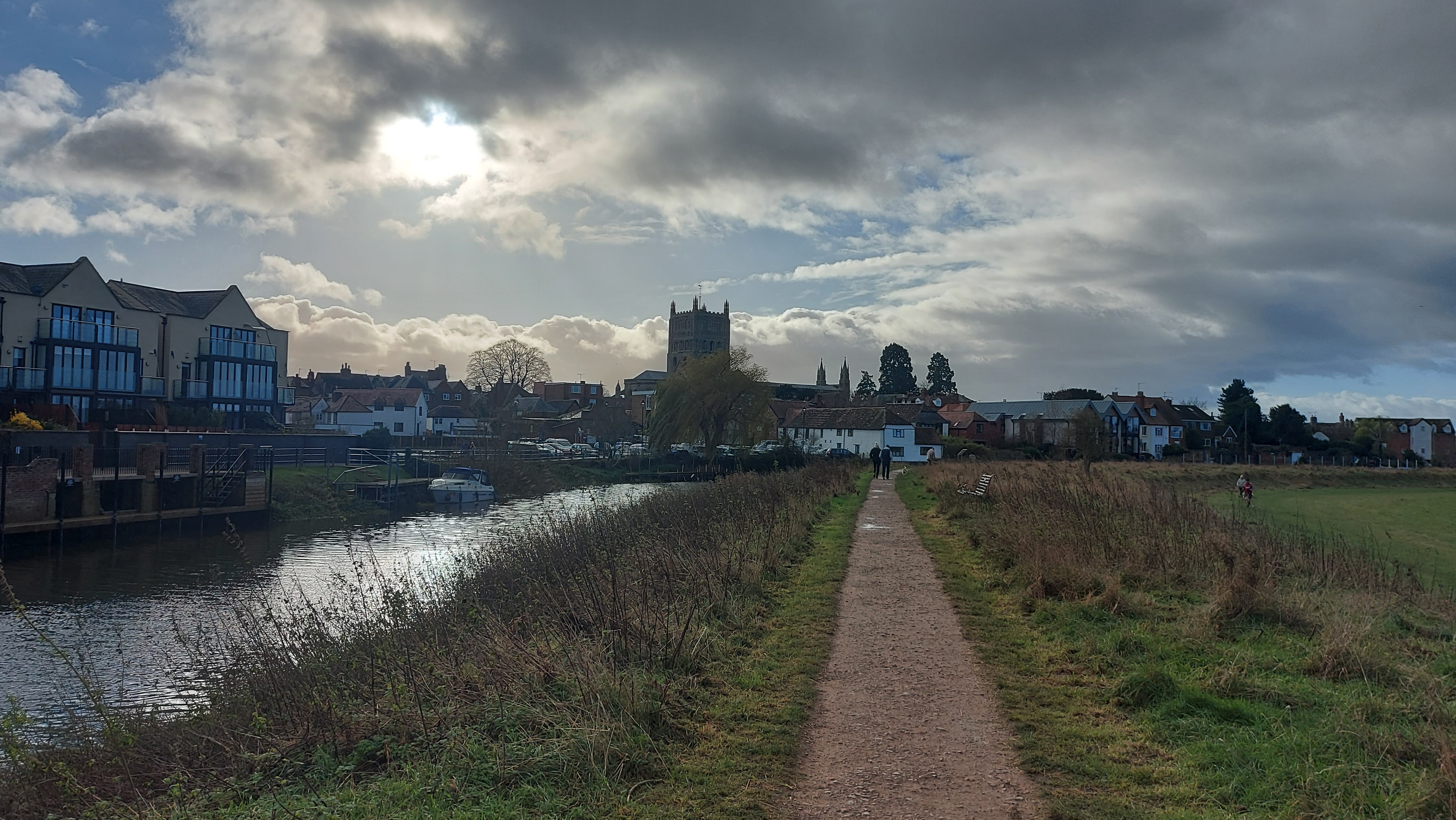
Bloody Meadow is a picturesque area located in the county of Gloucestershire, England. Situated amidst the beautiful Downs and Moorland, this region offers a unique and diverse landscape that attracts both locals and tourists alike.

Covering an extensive area, Bloody Meadow is characterized by its rolling hills, expansive grasslands, and scattered patches of woodland. The meadow gets its name from a historical event that took place here centuries ago, relating to a long-forgotten battle or local folklore.

The natural beauty of Bloody Meadow is further enhanced by its rich biodiversity. The area serves as a habitat for a variety of plant and animal species, making it a haven for nature lovers and wildlife enthusiasts. The wide expanse of grasslands provides ample grazing opportunities for livestock, contributing to the agricultural heritage of the region.

Visitors to Bloody Meadow can enjoy a range of outdoor activities, such as hiking, cycling, and birdwatching. The terrain offers numerous trails and pathways that wind through the hills and moorlands, providing stunning panoramic views of the surrounding countryside.

Bloody Meadow also holds cultural significance, with several historical landmarks scattered throughout the area. These include ancient burial mounds, archaeological sites, and remnants of old settlements, all of which provide a glimpse into the region's rich past.

Overall, Bloody Meadow in Gloucestershire is a captivating destination that seamlessly blends natural beauty, cultural heritage, and recreational opportunities, making it a must-visit location for anyone seeking to explore the charms of the English countryside.

If you have any feedback on the listing, please let us know in the comments section below.

Bloody Meadow Images

Images are sourced within 2km of 51.985293/-2.1677731 or Grid Reference SO8831. Thanks to Geograph Open Source API. All images are credited.

Southwick Farm View across farmland to Southwick Farm with the Malvern Hills in the distance.
Southwick Farm
View across farmland to Southwick Farm with the Malvern Hills in the distance.
New Housing Development On what I thought was the road from Walton Cardiff to Treddington.
The road has been stopped with the concrete bollards and houses springing up evertwhere. Not yet on the online OS map.
New Housing Development
On what I thought was the road from Walton Cardiff to Treddington. The road has been stopped with the concrete bollards and houses springing up evertwhere. Not yet on the online OS map.
Housing development, Tewkesbury In the foreground is a controversial housing development which has been built over the last ten years. The town of Tewkesbury is in the middle distance with the abbey to the left of centre. Beyond the town is Severn Ham, a large meadow which is cut for hay each summer.  The River Severn can be seen in the distance, with the Queenhill Bridge carrying the M50 motorway over the Severn near the top of the pictures and to the far right the river is passing Upper Lode.
Housing development, Tewkesbury
In the foreground is a controversial housing development which has been built over the last ten years. The town of Tewkesbury is in the middle distance with the abbey to the left of centre. Beyond the town is Severn Ham, a large meadow which is cut for hay each summer. The River Severn can be seen in the distance, with the Queenhill Bridge carrying the M50 motorway over the Severn near the top of the pictures and to the far right the river is passing Upper Lode.
The Wheatpieces, Tewkesbury Modern housing estate to the east of Tewkesbury, Snowdonia Road is pictured here.
The Wheatpieces, Tewkesbury
Modern housing estate to the east of Tewkesbury, Snowdonia Road is pictured here.
Footpath to Tewkesbury In the distance to the west is the substantial tower of Tewkesbury Abbey.
Footpath to Tewkesbury
In the distance to the west is the substantial tower of Tewkesbury Abbey.
Footpath west from the lane to Walton Cardiff The kissing gate is unneccessary with current land-use.
Footpath west from the lane to Walton Cardiff
The kissing gate is unneccessary with current land-use.
Hawkmoth Close Red-brick 90's housing on the outskirts of Tewkesbury.
Hawkmoth Close
Red-brick 90's housing on the outskirts of Tewkesbury.
Hawkmoth Close 2 Looking west within this housing development near Tewkesbury.
Hawkmoth Close 2
Looking west within this housing development near Tewkesbury.
Morrison's Supermarket Car Park, Tewkesbury
A438 approaching the Tewkesbury bypass On the left is Morrisons supermarket's car park.
A438 approaching the Tewkesbury bypass
On the left is Morrisons supermarket's car park.
Morrisons Supermarket, Tewkesbury
A438, Ashchurch Road Ashchurch Road, just to the east of Tewkesbury town centre.
A438, Ashchurch Road
Ashchurch Road, just to the east of Tewkesbury town centre.
Old railway line from Tewkesbury's first station Now a footpath, this was the course of the railway from Ashchurch to Tewkesbury's first railway station on a cramped site between Oldbury Road and High Street. 
It was replaced in 1864 by a later station, with the two lines joining in the middle distance of this image.
Old railway line from Tewkesbury's first station
Now a footpath, this was the course of the railway from Ashchurch to Tewkesbury's first railway station on a cramped site between Oldbury Road and High Street. It was replaced in 1864 by a later station, with the two lines joining in the middle distance of this image.
Tewkesbury By-Pass A38
Swilgate floods, Tewkesbury Waders would be needed for getting along this path after flooding around New Year 2014.
Swilgate floods, Tewkesbury
Waders would be needed for getting along this path after flooding around New Year 2014.
Dried-out winter teasel Plant alongside the Tewkesbury bypass with the blurred outline of the Abbey in the flooded distance.
Dried-out winter teasel
Plant alongside the Tewkesbury bypass with the blurred outline of the Abbey in the flooded distance.
Tewkesbury: track-bed of former railway towards Station, 1985 View NW from A38 Ashchurch Road: ex-Midland Ashchurch - Tewkesbury - Great Malvern branch, just west of the former Tewkesbury Junction to the site of the former 'new' station of 1864. (See <a href="https://www.geograph.org.uk/photo/1702660">SO8933 : Tewkesbury Station</a>] etc.). [Location of this view may be slightly incorrect]?
Tewkesbury: track-bed of former railway towards Station, 1985
View NW from A38 Ashchurch Road: ex-Midland Ashchurch - Tewkesbury - Great Malvern branch, just west of the former Tewkesbury Junction to the site of the former 'new' station of 1864. (See SO8933 : Tewkesbury Station] etc.). [Location of this view may be slightly incorrect]?
Tewkesbury 2nd railway station (site), Gloucestershire Opened in 1864 by the Midland Railway on the line from Ashchurch to Malvern, this station replaced an earlier terminus station in the town. In turn it itself was  closed to passengers in 1961, and completely in 1964.
View west towards Ripple and Malvern. The site has become completely wooded.
Tewkesbury 2nd railway station (site), Gloucestershire
Opened in 1864 by the Midland Railway on the line from Ashchurch to Malvern, this station replaced an earlier terminus station in the town. In turn it itself was closed to passengers in 1961, and completely in 1964. View west towards Ripple and Malvern. The site has become completely wooded.
Show me another place!

Bloody Meadow is located at Grid Ref: SO8831 (Lat: 51.985293, Lng: -2.1677731)

Administrative County: Gloucestershire

District: Tewkesbury

Police Authority: Gloucestershire

What 3 Words

///whistling.edicts.crouches. Near Tewkesbury, Gloucestershire

Nearby Locations

Bloody Meadow

Related Wikis

River Swilgate

The River Swilgate is a small river that flows through Gloucestershire, England. It is formed by the confluence at Elmstone Hardwicke of the Hyde Brook...

Battle of Tewkesbury

The Battle of Tewkesbury, which took place on 4 May 1471, was one of the most decisive battles of the Wars of the Roses in England. King Edward IV and...

Tewkesbury Abbey

The Abbey Church of St Mary the Virgin, Tewkesbury, commonly known as Tewkesbury Abbey, is located in the town of Tewkesbury in the ceremonial county of...

Tewkesbury

Tewkesbury ( TEWKS-bər-ee) is a market town and civil parish in the north of Gloucestershire, England. The town grew following the construction of Tewkesbury...

Nearby Amenities

Located within 500m of 51.985293,-2.1677731
Bus Stop
Council Offices
Bench: yes
Bin: no
Bus: yes
Departures Board: timetable
Flag: yes
Kerb: no
Lit: yes
Naptan AtcoCode: 1600GLT021
Naptan Bearing: NW
Naptan CommonName: Council Offices
Naptan Indicator: o/s
Naptan NaptanCode: glodmamw
Naptan Street: Gloucester Road
Naptan Verified: yes
Passenger Information Display: no
Pole: yes
Public Transport: platform
Shelter: yes
Source: naptan_import;survey
Tactile Paving: no
Lat/Long: 51.9865095/-2.1630376
Bus Stop
Council Offices
Bench: yes
Bin: no
Bus: yes
Departures Board: timetable
Flag: yes
Kerb: no
Lit: yes
Naptan AtcoCode: 1600GLT022
Naptan Bearing: SE
Naptan CommonName: Council Offices
Naptan Indicator: opp
Naptan NaptanCode: glodmapa
Naptan Street: Gloucester Road
Naptan Verified: yes
Passenger Information Display: no
Pole: yes
Public Transport: platform
Shelter: yes
Source: naptan_import;survey
Tactile Paving: no
Lat/Long: 51.986499/-2.1628145
Bus Stop
Council Offices Grounds
Bus: yes
Naptan AtcoCode: 1600GLT124
Naptan Bearing: N
Naptan CommonName: Council Offices Grounds
Naptan NaptanCode: glodmaja
Naptan Street: Off Gloucester Rd
Naptan Verified: no
Public Transport: platform
Source: naptan_import
Lat/Long: 51.986913/-2.1645099
Police
Tewkesbury Police Station
Operator: Gloucestershire Constabulary
Phone GB: 101
Website: https://www.gloucestershire.police.uk/
Lat/Long: 51.9870785/-2.1650629
Power: pole
Lat/Long: 51.9892035/-2.1656565
Post Box
Collection Times: Mo-Fr 09:00; Sa 07:00
Operator: Royal Mail
Operator Type: private
Operator Wikidata: Q638098
Post Box Mounting: pier
Post Box Type: lamp
Ref: GL20 29D
Royal Cypher: EIIR
Royal Cypher Wikidata: Q33102113
Lat/Long: 51.9856119/-2.1615835
Start Line Tewkesbury Half Marathon 2015
Lat/Long: 51.9849686/-2.1641679
Barrier: swing_gate
Material: metal
Swing Gate Type: double
Lat/Long: 51.9863564/-2.162584
Fixme: incomplete
Lat/Long: 51.9880331/-2.1636877
Barrier: kissing_gate
Lat/Long: 51.9880345/-2.1637267
Crossing
Crossing Island: yes
Lat/Long: 51.9856502/-2.1618079
Bench
Lat/Long: 51.9879238/-2.1631048
Bench
Lat/Long: 51.9879502/-2.1632284
Barrier: kissing_gate
Foot: designated
Lat/Long: 51.984697/-2.1646976
Bench
Source: survey
Lat/Long: 51.9882234/-2.1640545
Marker: pedestal
Operator: CLH
Operator Old: GPSS
Ref: CP 2373
Ref GPSS: 15169
Source: survey
Utility: oil
Lat/Long: 51.9848042/-2.1646124
Marker: aerial
Operator: CLH
Operator Old: GPSS
Ref: MP 2488
Ref GPSS: 15174
Source: survey
Utility: oil
Lat/Long: 51.9875425/-2.1664807
Power: pole
Lat/Long: 51.9878053/-2.1645965
Lower Lode Sewage Pumping Station
Location Transition: yes
Power: pole
Transformer: distribution
Voltage Primary: 11000
Lat/Long: 51.9883291/-2.1651676
Power: pole
Lat/Long: 51.9863057/-2.1633332
Power: pole
Lat/Long: 51.989472/-2.1653905
Power: pole
Lat/Long: 51.9883191/-2.165551
Power: pole
Lat/Long: 51.9859962/-2.1630897
Marker: aerial
Operator: CLH
Operator Old: GPSS
Ref GPSS: 15225
Source: survey
Utility: oil
Lat/Long: 51.9848141/-2.1646205
Marker: aerial
Operator: CLH
Operator Old: GPSS
Ref GPSS: 15198
Source: survey
Utility: oil
Lat/Long: 51.9872218/-2.1662841
Marker: aerial
Operator: CLH
Operator Old: GPSS
Ref: CP 2474
Ref GPSS: 15169
Source: survey
Utility: oil
Lat/Long: 51.9874127/-2.1664012
Marker: aerial
Operator: CLH
Operator Old: GPSS
Ref GPSS: 15195
Source: survey
Utility: oil
Lat/Long: 51.9864593/-2.1658167
Marker: aerial
Operator: CLH
Operator Old: GPSS
Ref GPSS: 19469
Source: survey
Utility: oil
Lat/Long: 51.9876932/-2.1665731
Marker: aerial
Operator: CLH
Operator Old: GPSS
Ref GPSS: 15185
Source: survey
Utility: oil
Lat/Long: 51.9842202/-2.1643657
Marker: pedestal
Operator: CLH
Operator Old: GPSS
Ref: MP 2487
Ref GPSS: 15169
Utility: oil
Lat/Long: 51.9844292/-2.1647532
Power: pole
Lat/Long: 51.9866559/-2.1634812
Location Transition: yes
Power: pole
Lat/Long: 51.9870432/-2.1658462
Lower Lode Lane Valve Chamber
Power: pole
Transformer: distribution
Voltage Primary: 11000
Lat/Long: 51.9866898/-2.1669137
Power: pole
Lat/Long: 51.9862628/-2.1681932
Power: pole
Lat/Long: 51.9855454/-2.1695839
Location Transition: yes
Power: pole
Lat/Long: 51.9848153/-2.1709169
STW Lower Lode Lane
Power: transformer
Transformer: distribution
Voltage Primary: 11000
Lat/Long: 51.9842287/-2.1716006
Location Transition: yes
Power: pole
Lat/Long: 51.9845588/-2.1717625
Power: pole
Lat/Long: 51.9844395/-2.1721206
Power: pole
Lat/Long: 51.9841376/-2.1730862
Tewkesbury Park Shed
Power: pole
Transformer: distribution
Voltage Primary: 11000
Lat/Long: 51.9832898/-2.1740364
Covered: no
Leisure: picnic_table
Lat/Long: 51.9884791/-2.1641732
Covered: no
Leisure: picnic_table
Lat/Long: 51.9885282/-2.1640887
Bench
Material: wood
Lat/Long: 51.988458/-2.1639962
Waste Basket
Waste: trash
Lat/Long: 51.9885199/-2.1637715
A Short Lived Reign
Board Type: history
Information: board
Tourism: information
Lat/Long: 51.9880868/-2.1640418
Waste Basket
Waste: trash
Lat/Long: 51.9881144/-2.1643254
Bench
Lat/Long: 51.9881144/-2.1648297
Bench
Lat/Long: 51.9882466/-2.164607
Bench
Lat/Long: 51.9882499/-2.1644072
Epidemics of Tewkesbury
Board Type: history
Information: board
Tourism: information
Lat/Long: 51.9864651/-2.1613857
Bench
Lat/Long: 51.9881888/-2.164196
Bench
Lat/Long: 51.9881314/-2.1642114
Waste Basket
Waste: rubbish bin;dog_excrement
Lat/Long: 51.9880409/-2.1637212
Waste Basket
Waste: trash
Lat/Long: 51.9863809/-2.1625659
Waste Basket
Waste: trash
Lat/Long: 51.9864345/-2.1615004
Cholera Monument
Historic: monument
Lat/Long: 51.9864878/-2.161385
Waste Basket
Waste: dog_excrement
Lat/Long: 51.9865758/-2.1613052
Barrier: cycle_barrier
Bicycle: yes
Material: metal
Lat/Long: 51.9865676/-2.1613476
Man Made: street_cabinet
Operator: Severn Trent Water
Lat/Long: 51.9882577/-2.1645541
Police
Tewkesbury Police Station
Opening Hours: We-Th 08:30-16:30
Operator: Gloucestershire Constabulary
Lat/Long: 51.9871484/-2.1646561
The data included in this document is from www.openstreetmap.org. The data is made available under ODbL.

Have you been to Bloody Meadow?

Leave your review of Bloody Meadow below (or comments, questions and feedback).