Ashholme Common

Downs, Moorland in Northumberland

England

Ashholme Common

Moorland, Coanwood
Moorland, Coanwood Credit: Andrew Smith

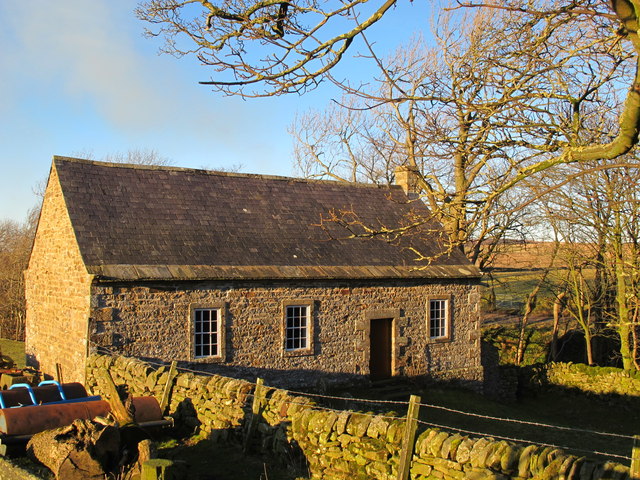
Ashholme Common, located in Northumberland, England, is a diverse and captivating natural landscape encompassing downs and moorland. Covering an area of approximately 500 acres, the common is a designated Site of Special Scientific Interest (SSSI) due to its exceptional ecological value and rich biodiversity.

The common is characterized by its undulating downs, which are covered in a variety of grasses, heather, and wildflowers. This habitat supports a wide range of plant species, including bilberry, heath bedstraw, and tormentil. The downs also provide ideal grazing grounds for sheep and other livestock, which contribute to the maintenance of the landscape through traditional farming practices.

In addition to the downs, Ashholme Common boasts expansive areas of moorland. The moorland is dominated by heather, which creates a vibrant purple carpet during the summer months. This habitat is important for several bird species, including the curlew, lapwing, and red grouse. Visitors to the common may be lucky enough to spot these iconic birds, as well as other wildlife such as hares, rabbits, and adders.

Ashholme Common is a beloved destination for nature enthusiasts, walkers, and photographers. Its picturesque landscapes and diverse flora and fauna make it an ideal location for outdoor exploration and appreciation of the natural world. The common's remote location and tranquil atmosphere offer a peaceful retreat from the hustle and bustle of everyday life, allowing visitors to connect with nature and experience the beauty of Northumberland's countryside.

If you have any feedback on the listing, please let us know in the comments section below.

Ashholme Common Images

Images are sourced within 2km of 54.906624/-2.4586031 or Grid Reference NY7056. Thanks to Geograph Open Source API. All images are credited.

Moorland, Coanwood
Moorland, Coanwood
Moorland, Coanwood
Moorland, Coanwood
Pen with corrugated metal shed The stone-walled sheep pen is on the north side of an estate road climbing from Eals giving access to moorland and a shooting hut.
Pen with corrugated metal shed
The stone-walled sheep pen is on the north side of an estate road climbing from Eals giving access to moorland and a shooting hut.
Ashholme Common west of the Millstone Band (2)
Coanwood Friends' Meeting House (3) The colours in the winter's late afternoon light are so different from those in the early afternoon in high summer (2010) shown in <a href="https://www.geograph.org.uk/photo/1958882">NY7058 : Coanwood Friends' Meeting House (2)</a>.
Coanwood Friends' Meeting House (3)
The colours in the winter's late afternoon light are so different from those in the early afternoon in high summer (2010) shown in NY7058 : Coanwood Friends' Meeting House (2).
Early 19th C gravestone at Coanwood Friends' Meeting House See <a href="https://www.geograph.org.uk/photo/3387280">NY7058 : Coanwood Friends' Meeting House (3)</a>.
Early 19th C gravestone at Coanwood Friends' Meeting House
Dykes Farm near Stonehouse
Track west of Burn House
Burn House
Burn House
Coanwood Friends Meeting House Coanwood Friends Meeting House was established in 1760 under the auspices of Cuthbert Wigham, a local landowner who had joined the Society of Friends, or ‘Quakers’, in 1734. Coanwood is significant in the fact that it has been spared major alteration since its construction in 1760. A simple, slate-roofed stone building, the date of its construction, 1760, is carved on the lintel above the entrance. There is a sloping walled graveyard to the front of the building with typical Quaker gravestones dating from the 19th century. The graveyard is thought to be full, but owing to Quaker tradition the majority of plots are unmarked. Gravestones were first prohibited in Quaker burial grounds by a Minute of London Yearly Meeting (the Quakers’ governing body) in 1717 which also urged the removal of those existing. It was not until 1850 that it was decided that plain headstones of uniform design were not inconsistent with Quaker principles. All of the gravestones in the grounds belong to members of the Wigham family, highlighting their enduring association with the Meeting House.
<span class="nowrap"><a title="http://www.hct.org.uk/chapels/north-east/coanwood-friends-meeting-house/10" rel="nofollow ugc noopener" href="http://www.hct.org.uk/chapels/north-east/coanwood-friends-meeting-house/10">Link</a><img style="margin-left:2px;" alt="External link" title="External link - shift click to open in new window" src="https://s1.geograph.org.uk/img/external.png" width="10" height="10"/></span>
Coanwood Friends Meeting House
Coanwood Friends Meeting House was established in 1760 under the auspices of Cuthbert Wigham, a local landowner who had joined the Society of Friends, or ‘Quakers’, in 1734. Coanwood is significant in the fact that it has been spared major alteration since its construction in 1760. A simple, slate-roofed stone building, the date of its construction, 1760, is carved on the lintel above the entrance. There is a sloping walled graveyard to the front of the building with typical Quaker gravestones dating from the 19th century. The graveyard is thought to be full, but owing to Quaker tradition the majority of plots are unmarked. Gravestones were first prohibited in Quaker burial grounds by a Minute of London Yearly Meeting (the Quakers’ governing body) in 1717 which also urged the removal of those existing. It was not until 1850 that it was decided that plain headstones of uniform design were not inconsistent with Quaker principles. All of the gravestones in the grounds belong to members of the Wigham family, highlighting their enduring association with the Meeting House. LinkExternal link
Stream west of Gorcock The unnamed stream is a tributary of the Coanwood Burn which it joins north of Burn House
Stream west of Gorcock
The unnamed stream is a tributary of the Coanwood Burn which it joins north of Burn House
Ruined building at Gorcock The small ruined farm building is on the south side of the track half-way between Dykes and Burn House farms.
Ruined building at Gorcock
The small ruined farm building is on the south side of the track half-way between Dykes and Burn House farms.
Bridge over Coanwood Burn by Burn House
Wigham gravestone at Coanwood Friends' Meeting House See <a href="https://www.geograph.org.uk/photo/1958875">NY7058 : Coanwood Friends' Meeting House</a>.
Wigham gravestone at Coanwood Friends' Meeting House
Dragonfly on a tree by Coanwood Friends' Meeting House
Moorland, Coanwood
Moorland, Coanwood
Moorland, Coanwood
Moorland, Coanwood
Moorland, Coanwood
Moorland, Coanwood
Show me another place!

Ashholme Common is located at Grid Ref: NY7056 (Lat: 54.906624, Lng: -2.4586031)

Unitary Authority: Northumberland

Police Authority: Northumbria

What 3 Words

///stars.fund.dustbin. Near Haltwhistle, Northumberland

Related Wikis

Coanwood Friends Meeting House

Coanwood Friends Meeting House is a redundant Quaker meeting house under the care of the Historic Chapels Trust. It stands in an isolated, sparsely populated...

Coanwood

Coanwood is a village in Northumberland, England, and is part of the Parish of Haltwhistle. It is about four miles (6 km) to the south-west of Haltwhistle...

Lambley railway station

Lambley was a railway station on the Alston Branch Line, which ran between Haltwhistle and Alston. The station, situated 4+3⁄4 miles (8 km) south-west...

Lambley, Northumberland

Lambley, formerly known as Harper Town, is a village and former civil parish, now in the parish of Coanwood, in Northumberland, England about four miles...

Have you been to Ashholme Common?

Leave your review of Ashholme Common below (or comments, questions and feedback).