Ashholme Common

Hill, Mountain in Northumberland

England

Ashholme Common

Moorland, Coanwood
Moorland, Coanwood Credit: Andrew Smith

Ashholme Common is a small hill located in Northumberland, England. Situated in the northern part of the county, it is part of the North Pennines Area of Outstanding Natural Beauty. With an elevation of approximately 200 meters (656 feet), it is considered a modest hill rather than a mountain.

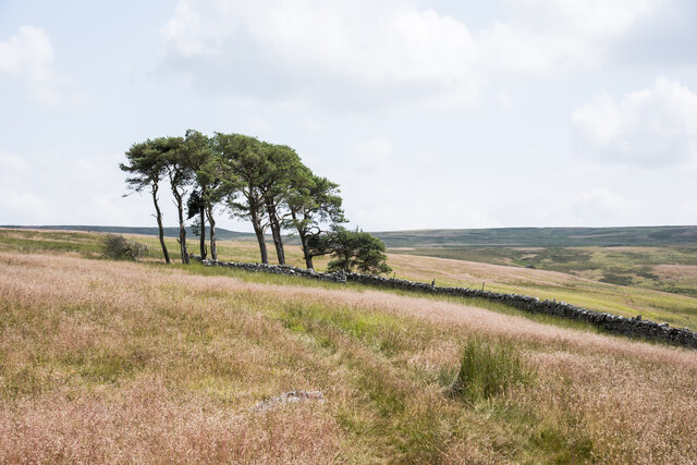
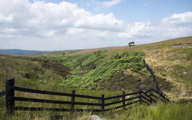
The common is characterized by its rolling landscape and rugged terrain, typical of the North Pennines region. It is covered in a mix of heather, grasses, and scattered shrubs, creating a picturesque and wild environment. The hill offers stunning panoramic views of the surrounding countryside, including nearby moorlands, valleys, and distant hills.

Ashholme Common is a popular destination for outdoor enthusiasts and nature lovers. It provides ample opportunities for hiking, walking, and birdwatching. The area is home to a variety of bird species, including red grouse, lapwings, and curlews, making it an ideal spot for ornithologists.

The hill is easily accessible, with several footpaths leading to its summit. These paths wind through the heather-covered slopes, offering visitors a chance to immerse themselves in the natural beauty of the area. The common is also relatively remote, providing a peaceful and tranquil escape from the hustle and bustle of urban life.

Overall, Ashholme Common is a charming and picturesque hill in Northumberland, offering visitors a chance to explore the stunning landscapes of the North Pennines and experience the tranquility of the countryside.

If you have any feedback on the listing, please let us know in the comments section below.

Ashholme Common Images

Images are sourced within 2km of 54.900772/-2.4569616 or Grid Reference NY7056. Thanks to Geograph Open Source API. All images are credited.

Moorland, Coanwood
Moorland, Coanwood
Moorland, Coanwood
Moorland, Coanwood
Pen with corrugated metal shed The stone-walled sheep pen is on the north side of an estate road climbing from Eals giving access to moorland and a shooting hut.
Pen with corrugated metal shed
The stone-walled sheep pen is on the north side of an estate road climbing from Eals giving access to moorland and a shooting hut.
Ashholme Common west of the Millstone Band (2)
Moorland, Coanwood
Moorland, Coanwood
Moorland, Coanwood
Moorland, Coanwood
Moorland, Coanwood
Moorland, Coanwood
Moorland, Coanwood
Moorland, Coanwood
Moorland, Coanwood
Moorland, Coanwood
Trees on moorland, beside dry stone wall The trees lie beyond the end of a hill road climbing from Eals on to Snope Common above the valley of the Snope Burn. An ATV track continues for some way beyond the road end, it can be seen in the foreground passing over grass which has gone to seed.
Trees on moorland, beside dry stone wall
The trees lie beyond the end of a hill road climbing from Eals on to Snope Common above the valley of the Snope Burn. An ATV track continues for some way beyond the road end, it can be seen in the foreground passing over grass which has gone to seed.
Shooting hut beside road on Snope Common / Eals Fell The road has climbed from the small village of Eals in the South Tyne valley.
Shooting hut beside road on Snope Common / Eals Fell
The road has climbed from the small village of Eals in the South Tyne valley.
Upper groove of Snope Burn At about this location on Snope Common a number of feeding streams have come together forming Snope Burn. There's a footbridge just below; it comes up beside the black-painted fence with steps rising from the bridge itself; the top step is in view.
Upper groove of Snope Burn
At about this location on Snope Common a number of feeding streams have come together forming Snope Burn. There's a footbridge just below; it comes up beside the black-painted fence with steps rising from the bridge itself; the top step is in view.
Eals Fell A quarry on the left still seems to be used on a small scale.
Eals Fell
A quarry on the left still seems to be used on a small scale.
Track, Eals Fell View across the South Tyne valley to the Cold Fell moorlands.
Track, Eals Fell
View across the South Tyne valley to the Cold Fell moorlands.
Moorland above Coanwood A broken wall with shooting butts above the South Tyne valley.
Moorland above Coanwood
A broken wall with shooting butts above the South Tyne valley.
Wallace's Crags Wallace's Crags are a line of bouldery steeper ground on the moorland above the South Tyne. This shows their southern end, viewed from the northern end of the less extensive Peas Crag.
Wallace's Crags
Wallace's Crags are a line of bouldery steeper ground on the moorland above the South Tyne. This shows their southern end, viewed from the northern end of the less extensive Peas Crag.
Shooting butts, Coanwood Looking across the South Tyne valley to Cold Fell and Glendue Burn.
Shooting butts, Coanwood
Looking across the South Tyne valley to Cold Fell and Glendue Burn.
Moorland, Coanwood A ruined wall points the way down to the South Tyne valley, Hadrian's Wall and the border country.
Moorland, Coanwood
A ruined wall points the way down to the South Tyne valley, Hadrian's Wall and the border country.
Show me another place!

Ashholme Common is located at Grid Ref: NY7056 (Lat: 54.900772, Lng: -2.4569616)

Unitary Authority: Northumberland

Police Authority: Northumbria

What 3 Words

///clear.cooked.clots. Near Haltwhistle, Northumberland

Related Wikis

Coanwood Friends Meeting House

Coanwood Friends Meeting House is a redundant Quaker meeting house under the care of the Historic Chapels Trust. It stands in an isolated, sparsely populated...

Lambley railway station

Lambley was a railway station on the Alston Branch Line, which ran between Haltwhistle and Alston. The station, situated 4+3⁄4 miles (8 km) south-west...

Coanwood

Coanwood is a village in Northumberland, England, and is part of the Parish of Haltwhistle. It is about four miles (6 km) to the south-west of Haltwhistle...

Lambley, Northumberland

Lambley, formerly known as Harper Town, is a village and former civil parish, now in the parish of Coanwood, in Northumberland, England about four miles...

Nearby Amenities

Located within 500m of 54.900772,-2.4569616
Great Black Pike
Ele: 446
Natural: peak
Source: Bing
Lat/Long: 54.9007628/-2.4566525
The data included in this document is from www.openstreetmap.org. The data is made available under ODbL.

Have you been to Ashholme Common?

Leave your review of Ashholme Common below (or comments, questions and feedback).