Hampton Lucy

Settlement in Warwickshire Stratford-on-Avon

England

Hampton Lucy

St Leonard's Church, Charlecote A Grade I listed church dating from 1851. It is viewed from Charlecote Park.
St Leonard's Church, Charlecote Credit: Bill Boaden

Hampton Lucy is a small village located in the county of Warwickshire, England. Situated near the banks of the River Avon, it lies approximately 3 miles east of the historic town of Warwick. The village is known for its picturesque setting and charming rural atmosphere.

Hampton Lucy has a long and rich history, with evidence of human activity dating back to prehistoric times. The village's name is believed to originate from the Old English words "ham" meaning settlement and "tun" meaning homestead, reflecting its origins as a Saxon settlement.

One of the notable landmarks in Hampton Lucy is the St. Peter's Church, a Grade II listed building that dates back to the 12th century. The church features a Norman tower and houses several interesting historical artifacts, including a medieval font and a 17th-century pulpit.

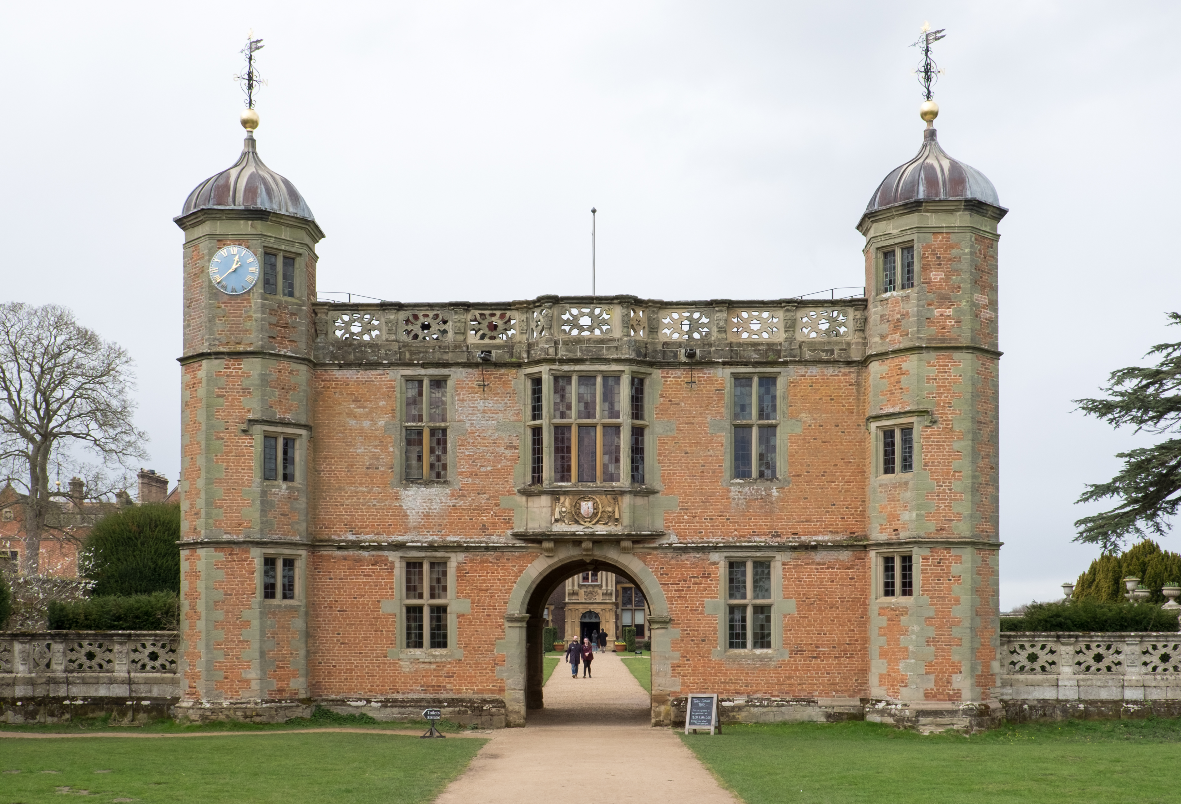
The village is also home to Hampton Lucy Hall, an elegant Georgian mansion that is now privately owned. The hall is set within extensive grounds and offers a glimpse into the area's affluent past.

Hampton Lucy benefits from its proximity to the River Avon, which provides opportunities for scenic walks and outdoor activities. The village is surrounded by beautiful countryside, with rolling hills and farmland adding to its idyllic charm.

While Hampton Lucy is a small village, it is conveniently located near larger towns such as Warwick and Stratford-upon-Avon, offering residents access to a range of amenities and services. Overall, Hampton Lucy is a tranquil and picturesque village that encapsulates the timeless beauty of the Warwickshire countryside.

If you have any feedback on the listing, please let us know in the comments section below.

Hampton Lucy Images

Images are sourced within 2km of 52.211761/-1.626263 or Grid Reference SP2557. Thanks to Geograph Open Source API. All images are credited.

St Leonard's Church, Charlecote A Grade I listed church dating from 1851. It is viewed from Charlecote Park.
St Leonard's Church, Charlecote
A Grade I listed church dating from 1851. It is viewed from Charlecote Park.
Path round the edge of the Charlecote Estate The National Trust have put up a sign closing this bit of path due to flooding. There are Jacob sheep ahead.
Path round the edge of the Charlecote Estate
The National Trust have put up a sign closing this bit of path due to flooding. There are Jacob sheep ahead.
Deer in Charlecote Park Part of a herd of fallow deer that live in this National Trust estate.
Deer in Charlecote Park
Part of a herd of fallow deer that live in this National Trust estate.
Lake in Charlecote Park An ornamental lake which is fed by a small stream and drains into the River Avon. The parish church of Hampton Lucy can be seen through the trees.
Lake in Charlecote Park
An ornamental lake which is fed by a small stream and drains into the River Avon. The parish church of Hampton Lucy can be seen through the trees.
Places Meadow Part of a flood plain of the River Avon within the Charlecote Estate.
Places Meadow
Part of a flood plain of the River Avon within the Charlecote Estate.
Places Meadow The northern end of Charlecote Park.
Places Meadow
The northern end of Charlecote Park.
One branch of the River Avon below Charlecote Mill The river splits below the mill. This branch is somewhat overgrown with shrubbery. It marks the edge of Charlecote Park.
One branch of the River Avon below Charlecote Mill
The river splits below the mill. This branch is somewhat overgrown with shrubbery. It marks the edge of Charlecote Park.
The River Avon at Hampton Lucy The two branches of the river below Charlecote Mill have just been reunited. St Peter ad Vincula Church in Hampton Lucy is opposite. This view is from Places Meadow in Charlecote Park.
The River Avon at Hampton Lucy
The two branches of the river below Charlecote Mill have just been reunited. St Peter ad Vincula Church in Hampton Lucy is opposite. This view is from Places Meadow in Charlecote Park.
Bench overlooking the River Avon Situated on Places Meadow in Charlecote Park. On the other side of the river is the village of Hampton Lucy.
Bench overlooking the River Avon
Situated on Places Meadow in Charlecote Park. On the other side of the river is the village of Hampton Lucy.
River Avon at Charlecote Park A view from the formal garden between the house and the river, looking towards Hampton Lucy where the church tower can be seen.
River Avon at Charlecote Park
A view from the formal garden between the house and the river, looking towards Hampton Lucy where the church tower can be seen.
Charlecote Park A country estate managed by the National Trust. The house dates mostly from the Victorian era but was rebuilt to resemble an earlier building on the site. The River Avon flows next to it. The land in the foreground is a deer sanctuary, but the deer were all elsewhere on this day. The lighting reflects a late winter afternoon.
Charlecote Park
A country estate managed by the National Trust. The house dates mostly from the Victorian era but was rebuilt to resemble an earlier building on the site. The River Avon flows next to it. The land in the foreground is a deer sanctuary, but the deer were all elsewhere on this day. The lighting reflects a late winter afternoon.
Evening stillness descending on Charlecote Park This is the River Dene about to flow into the Avon which can be seen ahead.
Evening stillness descending on Charlecote Park
This is the River Dene about to flow into the Avon which can be seen ahead.
Charlecote Park: National Trust Car Park, new layout
Hampton Lucy, St. Peter ad Vincula Church
Hampton Lucy, St. Peter ad Vincula Church: Blind arcading on the south wall
Hampton Lucy, St. Peter ad Vincula Church: The polygonal apse
Show me another place!

Hampton Lucy is located at Grid Ref: SP2557 (Lat: 52.211761, Lng: -1.626263)

Administrative County: Warwickshire

District: Stratford-on-Avon

Police Authority: Warwickshire

What 3 Words

///doped.posts.scorpions. Near Wellesbourne Mountford, Warwickshire

Related Wikis

Hampton Lucy

Hampton Lucy is a village and civil parish on the River Avon, 4 miles (6.4 km) northeast of Stratford-upon-Avon in Warwickshire England. The population...

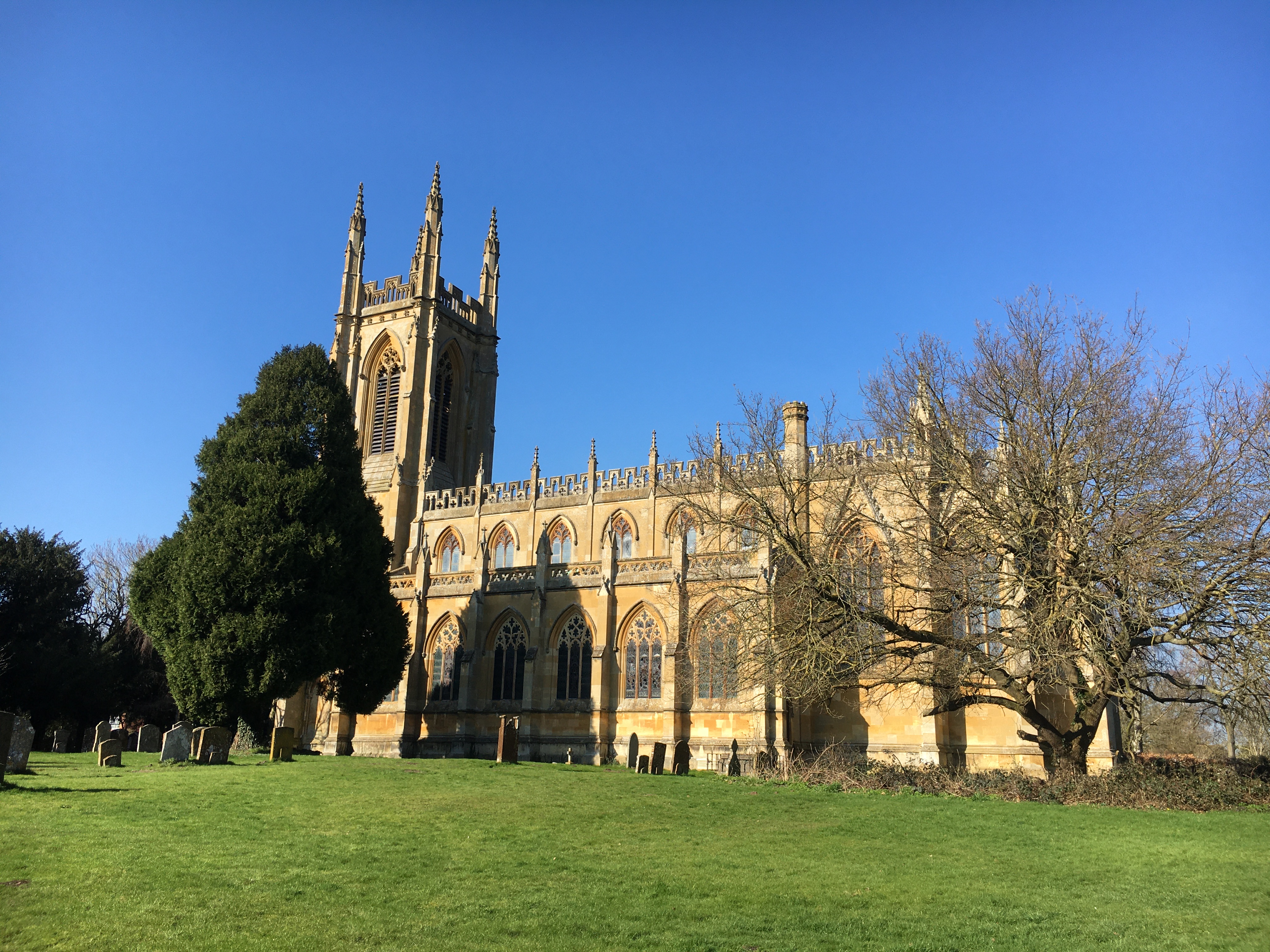
St Peter ad Vincula Church, Hampton Lucy

St Peter ad Vincula is the Grade I listed Church of England parish church of Hampton Lucy, Warwickshire and is part of the Barford Group of Churches. It...
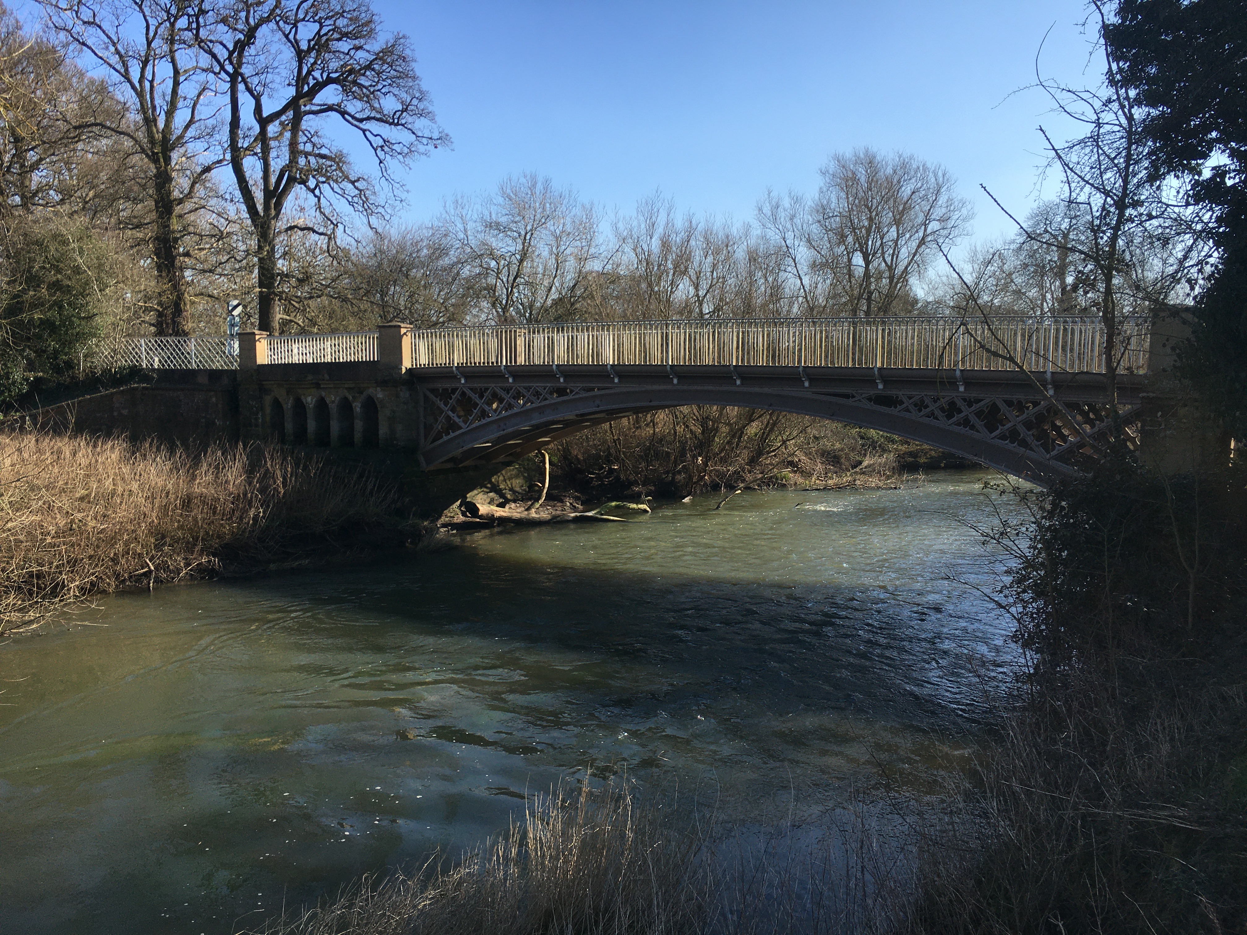
Hampton Lucy Bridge

Hampton Lucy Bridge is a cast iron bridge over the River Avon at the east end of the village of Hampton Lucy in Warwickshire, England. It was originally...

Charlecote Mill

Charlecote Mill is a watermill in Hampton Lucy, Warwickshire, England, near to Charlecote Park and about 4 miles (6 km) east of Stratford-upon-Avon. It...
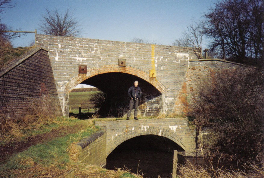
River Dene

The River Dene is a small river in Warwickshire, England. It is a tributary of the Avon, which it joins at Charlecote Park. The headwaters of the River...

Charlecote

Charlecote is a small village and civil parish 5 miles (8.0 km) south of Warwick, on the River Avon, in the Stratford-on-Avon district, in the county of...
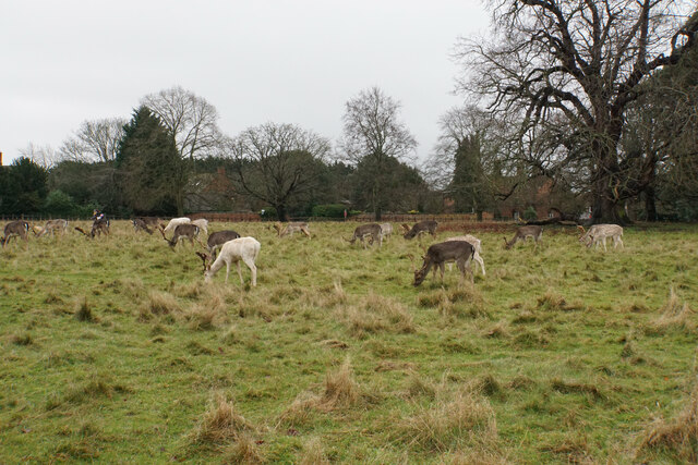
Charlecote Park

Charlecote Park (grid reference SP263564) is a grand 16th-century country house, surrounded by its own deer park, on the banks of the River Avon in Charlecote...

Thelsford Priory

Thelsford Priory is a site listed by the Historic Buildings and Monuments Commission for England.Thelsford Priory was a small house, originally of the...

Nearby Amenities

Located within 500m of 52.211761,-1.626263
Source: gps_survey
Lat/Long: 52.2111134/-1.6284298
Source: gps_survey
Lat/Long: 52.2111354/-1.6272495
Source: gps_survey
Lat/Long: 52.2117894/-1.6262415
Bus Stop
Church
Bus: yes
Naptan AtcoCode: 4200F025600
Naptan Bearing: NE
Naptan CommonName: Church
Naptan Indicator: Opp
Naptan NaptanCode: wardgjmw
Naptan Street: Church Street
Naptan Verified: no
Public Transport: platform
Source: naptan_import
Lat/Long: 52.2112893/-1.6270133
Church
Naptan AtcoCode: 4200F025601
Naptan Bearing: W
Naptan BusStopType: CUS
Naptan CommonName: Church
Naptan Indicator: Adj
Naptan NaptanCode: wardjagd
Naptan Street: Church Street
Naptan Verified: no
Source: naptan_import
Lat/Long: 52.2110105/-1.6269864
Hampton Lucy
Place: village
Wikidata: Q5646251
Lat/Long: 52.2116419/-1.6273426
Addr Country: GB
Addr Housename: Jasmine Cottage
Addr Street: Church Street
Lat/Long: 52.2112219/-1.6277627
Addr Country: GB
Addr Housename: Merchants House
Addr Street: Church Street
Lat/Long: 52.211229/-1.6276238
Addr Country: GB
Addr Housenumber: 8
Addr Street: Church Street
Lat/Long: 52.2112442/-1.6274617
Post Box
Collection Times: Mo-Fr 15:45; Sa 10:00
Operator: Royal Mail
Post Box Type: lamp
Ref: CV35 92
Royal Cypher: EIIR
Royal Cypher Wikidata: Q33102113
Source: survey
Lat/Long: 52.2111068/-1.6270069
Public Bookcase
Booth: K6
Disused Amenity: telephone
Man Made: telephone_box
Public Bookcase Type: phone_box
Source: survey
Lat/Long: 52.2111567/-1.6269169
Pipeline: marker
Source: survey
Lat/Long: 52.2089035/-1.623985
Pipeline: marker
Source: survey
Lat/Long: 52.2089742/-1.6236739
Pipeline: marker
Source: survey
Lat/Long: 52.2108068/-1.6205746
Pipeline: marker
Source: survey
Lat/Long: 52.2107566/-1.6206926
Generator Method: photovoltaic
Generator Output Electricity: yes
Generator Source: solar
Generator Type: solar_photovoltaic_panel
Location: roof
Power: generator
Lat/Long: 52.2127494/-1.6274759
Defibrillator
Defibrillator Location: outside Hampton Lucy Village Hall, Church Street, Hampton Lucy, CV35 8BE, by door to Village Hall
Emergency: defibrillator
Indoor: no
Ref: 1950
Source: survey
Lat/Long: 52.2109212/-1.6283341
Bench
Lat/Long: 52.211206/-1.6268556
Information: board
Tourism: information
Lat/Long: 52.2111074/-1.6269441
Entrance: yes
Lat/Long: 52.2109154/-1.6283374
The data included in this document is from www.openstreetmap.org. The data is made available under ODbL.

Have you been to Hampton Lucy?

Leave your review of Hampton Lucy below (or comments, questions and feedback).