St Michaels Park

Downs, Moorland in Gloucestershire Forest of Dean

England

St Michaels Park

Cycleway and former railway Cycleway and former railway trackbed passing through Crabtreehill Plantation in the Forest of Dean.
Cycleway and former railway Credit: Philip Halling

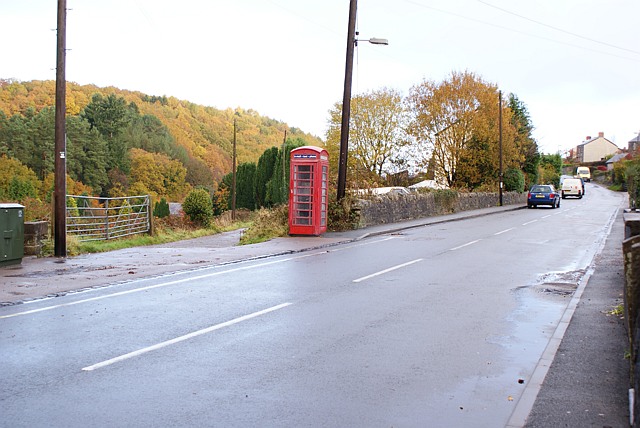
St Michaels Park is a picturesque and serene nature reserve located in Gloucestershire, England. The park spans over a vast area, encompassing both downs and moorland landscapes, offering visitors a diverse and captivating experience.

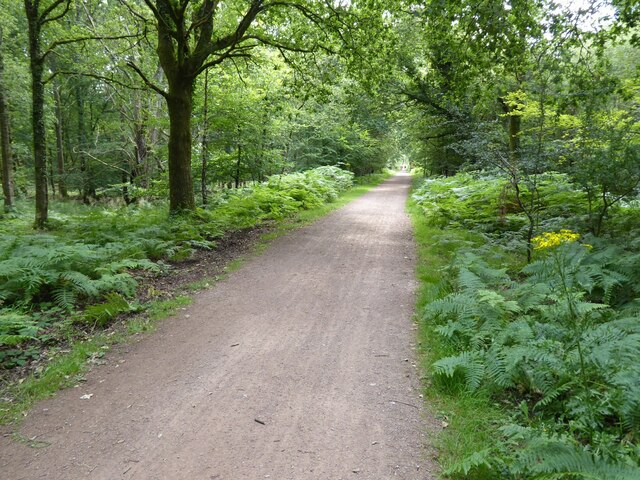
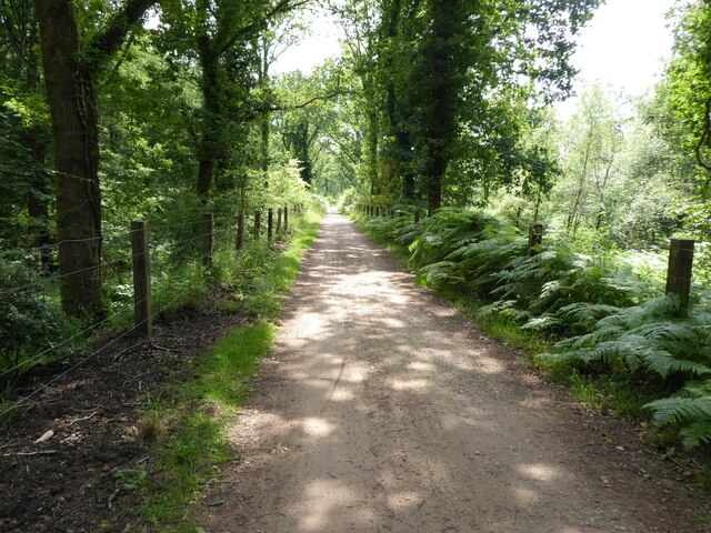
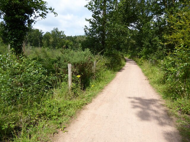
The downs section of St Michaels Park is characterized by rolling hills covered in lush green grass, providing ample space for leisurely walks and picnics. The open expanse offers stunning panoramic views of the surrounding countryside, making it a popular spot for nature enthusiasts and photographers alike. The downs are also home to a rich variety of flora and fauna, including wildflowers, butterflies, and birds, providing a haven for wildlife enthusiasts.

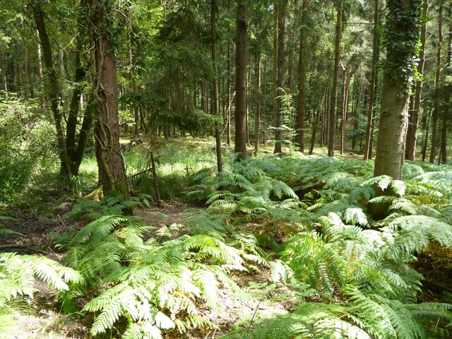
The moorland section of the park is a stark contrast to the downs, with its rugged and untamed terrain. Here, visitors can explore winding trails that lead through heather-covered hills and ancient woodlands. The moorland is known for its tranquility and solitude, offering a peaceful retreat for those seeking a break from the hustle and bustle of everyday life.

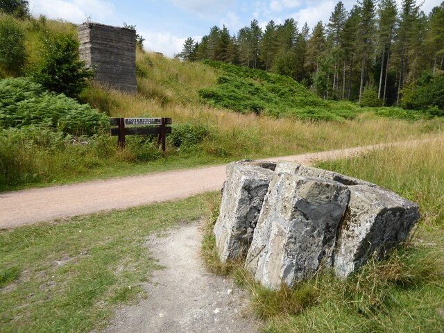
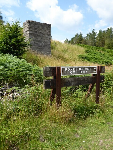
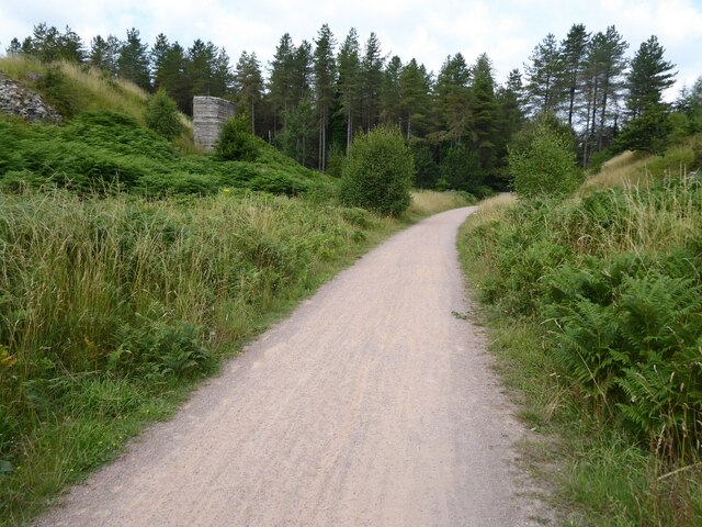
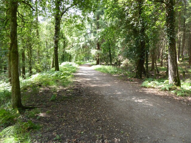
In addition to its natural beauty, St Michaels Park boasts a range of amenities to enhance visitors' experience. There are well-maintained footpaths and trails throughout the park, making it accessible for walkers and hikers of all abilities. Picnic areas and benches are strategically placed, offering visitors the opportunity to relax and enjoy the scenery. Interpretive boards and signage provide informative details about the park's history, geology, and wildlife, adding an educational element to the visit.

Overall, St Michaels Park is a haven of natural beauty, offering visitors a chance to immerse themselves in the stunning landscapes of downs and moorland, while also providing opportunities for relaxation, exploration, and wildlife-spotting.

If you have any feedback on the listing, please let us know in the comments section below.

St Michaels Park Images

Images are sourced within 2km of 51.808763/-2.5070999 or Grid Reference SO6512. Thanks to Geograph Open Source API. All images are credited.

Cycleway and former railway Cycleway and former railway trackbed passing through Crabtreehill Plantation in the Forest of Dean.
Cycleway and former railway
Cycleway and former railway trackbed passing through Crabtreehill Plantation in the Forest of Dean.
Site of Foxes Bridge Colliery Former railway track and now a cycleway passing through the site of Foxes Bridge Colliery.  Trees have been felled since I last photographed this site just over seven years ago <a href="https://www.geograph.org.uk/photo/3954592">SO6313 : Foxes Bridge Colliery</a>.
Site of Foxes Bridge Colliery
Former railway track and now a cycleway passing through the site of Foxes Bridge Colliery. Trees have been felled since I last photographed this site just over seven years ago SO6313 : Foxes Bridge Colliery.
Site of Foxes Bridge Colliery The site of Foxes Bridge Colliery viewed from a former railway track and now cycleway.
Site of Foxes Bridge Colliery
The site of Foxes Bridge Colliery viewed from a former railway track and now cycleway.
Site of Foxes Bridge Colliery Former railway track and now a cycleway passing through the site of Foxes Bridge Colliery.
Site of Foxes Bridge Colliery
Former railway track and now a cycleway passing through the site of Foxes Bridge Colliery.
Cycleway passing through Crabtreehill Plantation Cycleway on a former railway trackbed passing through Crabtreehill Plantation.
Cycleway passing through Crabtreehill Plantation
Cycleway on a former railway trackbed passing through Crabtreehill Plantation.
Cycleway near Dilke Hospital Cycleway and former railway trackbed near Dilke Hospital in the Forest of Dean.
Cycleway near Dilke Hospital
Cycleway and former railway trackbed near Dilke Hospital in the Forest of Dean.
Dilke Hospital Dilke Memorial Hospital opened in 1921 and is named after Sir Charles Dilke, 2nd Baronet who was a Liberal MP for the Forest of Dean and died in 1911.
Dilke Hospital
Dilke Memorial Hospital opened in 1921 and is named after Sir Charles Dilke, 2nd Baronet who was a Liberal MP for the Forest of Dean and died in 1911.
Former Lightmoor Colliery Engine House The derelict engine house of the former Lightmoor Colliery viewed from the cycleway which passes by following a former railway.
Former Lightmoor Colliery Engine House
The derelict engine house of the former Lightmoor Colliery viewed from the cycleway which passes by following a former railway.
Forestry at Great Palescot Ferns and trees at Great Palescot in the Forest of Dean.
Forestry at Great Palescot
Ferns and trees at Great Palescot in the Forest of Dean.
Cycleway near Great Saintlow Cycleway and former railway trackbed near Great Saintlow.
Cycleway near Great Saintlow
Cycleway and former railway trackbed near Great Saintlow.
Pump bob - Foxes Bridge Colliery near Cinderford This inverted tee bob was undoubtedly associated with a steam pumping engine for draining this colliery and has been retained on site on a specially made concrete pad. Unfortunately it is being reclaimed by nature and is fairly well hidden although there is a well established path to it. It took me a while of hunting to find it from the nearby cycle trail.
Pump bob - Foxes Bridge Colliery near Cinderford
This inverted tee bob was undoubtedly associated with a steam pumping engine for draining this colliery and has been retained on site on a specially made concrete pad. Unfortunately it is being reclaimed by nature and is fairly well hidden although there is a well established path to it. It took me a while of hunting to find it from the nearby cycle trail.
Dilke Memorial Hospital near Cinderford
Trig point near Crabtree Hill, forest of Dean
Entrance to Forest of Dean Crematorium
Remains of Foxes Bridge Colliery near Cinderford Some large lumps of masonry adjoining a cycle trail through the site. There are other interesting foundations and the remains of a pumping bob nearby but they do take a little hunting for.
Remains of Foxes Bridge Colliery near Cinderford
Some large lumps of masonry adjoining a cycle trail through the site. There are other interesting foundations and the remains of a pumping bob nearby but they do take a little hunting for.
Junction of tracks near the site of Foxes Bridge Colliery The crossing track is a family cycle way. The houses in the distance are in Cinderford
Junction of tracks near the site of Foxes Bridge Colliery
The crossing track is a family cycle way. The houses in the distance are in Cinderford
Site of Foxes Bridge Colliery The cycle way passing through behind the large lump of masonry is on the track bed of a former railway serving the colliery. There are quite a few remains in the undergrowth including an inverted tee bob from a pumping engine.
Site of Foxes Bridge Colliery
The cycle way passing through behind the large lump of masonry is on the track bed of a former railway serving the colliery. There are quite a few remains in the undergrowth including an inverted tee bob from a pumping engine.
Show me another place!

St Michaels Park is located at Grid Ref: SO6512 (Lat: 51.808763, Lng: -2.5070999)

Administrative County: Gloucestershire

District: Forest of Dean

Police Authority: Gloucestershire

What 3 Words

///summer.punk.worlds. Near Cinderford, Gloucestershire

Related Wikis

Ruspidge Halt railway station

Ruspidge Halt railway station is a disused railway station opened by the Great Western Railway (GWR) on the former Bullo Pill Railway, later known as the...

Ruspidge

Ruspidge is a village in the Forest of Dean district of west Gloucestershire, England. The civil parish includes Soudley It is located near the town of...

Buckshraft Mine & Bradley Hill Railway Tunnel

Buckshaft Mine & Bradley Hill Railway Tunnel (SO655121 and SO662104) is a 5.66-hectare (14.0-acre) biological Site of Special Scientific Interest in Gloucestershire...

Cinderford Ironworks

Cinderford Ironworks, also known as Cinderford Furnace, was a coke-fired blast furnace, built in 1795, just west of Cinderford, in the Forest of Dean,...

Staple Edge Halt railway station

Staple Edge Halt railway station is a disused railway station opened by the Great Western Railway (GWR) on the former Bullo Pill Railway, later known as...

Eastern United Colliery

Eastern United Colliery was a drift mine in the Forest of Dean, Gloucestershire, England served by the Great Western Railway's Forest of Dean Branch. The...

Soudley Ponds

Lying close to the village of Soudley in the Forest of Dean, west Gloucestershire, Soudley Ponds (grid reference SO662112), also known as Sutton Ponds...

Cinderford

Cinderford is a town and civil parish on the eastern fringe of the Forest of Dean in Gloucestershire, England. The population was 8,777 at the 2021 Census...

Nearby Amenities

Located within 500m of 51.808763,-2.5070999
Bus Stop
Dean View
Naptan AtcoCode: 1600GL1212
Naptan Bearing: SW
Naptan CommonName: Dean View
Naptan NaptanCode: gloajgwd
Naptan Street: Buckshaft Rd
Naptan Verified: no
Source: naptan_import
Lat/Long: 51.8062443/-2.5036085
Bus Stop
White Hart
Naptan AtcoCode: 1600GL1261
Naptan Bearing: SW
Naptan CommonName: White Hart
Naptan Indicator: Opp
Naptan NaptanCode: gloajgpw
Naptan Street: St White's Rd
Naptan Verified: no
Source: naptan_import
Lat/Long: 51.8117075/-2.5044382
Bus Stop
White Hart
Naptan AtcoCode: 1600GL1262
Naptan Bearing: NE
Naptan CommonName: White Hart
Naptan NaptanCode: gloajgtd
Naptan Street: St White's Rd
Naptan Verified: no
Source: naptan_import
Lat/Long: 51.8119238/-2.5043101
Bus Stop
Lower Ruspidge Stores
Naptan AtcoCode: 1600GL4063
Naptan Bearing: SW
Naptan CommonName: Lower Ruspidge Stores
Naptan Indicator: Opp
Naptan NaptanCode: gloajgdj
Naptan Street: Ruspidge Rd
Naptan Verified: no
Source: naptan_import
Lat/Long: 51.8059957/-2.5070577
Bus Stop
Lower Ruspidge Stores
Naptan AtcoCode: 1600GL4064
Naptan Bearing: NE
Naptan CommonName: Lower Ruspidge Stores
Naptan NaptanCode: gloajgda
Naptan Street: Ruspidge Rd
Naptan Verified: no
Source: naptan_import
Lat/Long: 51.8060764/-2.5071166
Bus Stop
White Hart
Naptan AtcoCode: 1600GL4067
Naptan Bearing: S
Naptan CommonName: White Hart
Naptan NaptanCode: gloajgtw
Naptan Street: Ruspidge Rd
Naptan Verified: no
Source: naptan_import
Lat/Long: 51.8117086/-2.5041626
Bus Stop
White Hart
Naptan AtcoCode: 1600GL4068
Naptan Bearing: N
Naptan CommonName: White Hart
Naptan NaptanCode: gloajgtj
Naptan Street: Ruspidge Rd
Naptan Verified: no
Source: naptan_import
Lat/Long: 51.8116812/-2.5042638
Bus Stop
Cinderford Bridge
Naptan AtcoCode: 1600GL5629
Naptan Bearing: SE
Naptan CommonName: Cinderford Bridge
Naptan NaptanCode: gloajgad
Naptan Street: St White's Rd
Naptan Verified: no
Source: naptan_import
Lat/Long: 51.8109911/-2.5079406
Bus Stop
Cinderford Bridge
Naptan AtcoCode: 1600GL5630
Naptan Bearing: NW
Naptan CommonName: Cinderford Bridge
Naptan NaptanCode: gloajdwm
Naptan Street: St White's Rd
Naptan Verified: no
Source: naptan_import
Lat/Long: 51.8109897/-2.5082597
Bus Stop
Cinderford Bridge
Naptan AtcoCode: 1600GL665
Naptan Bearing: S
Naptan CommonName: Cinderford Bridge
Naptan NaptanCode: gloajdwt
Naptan Street: Valley Rd
Naptan Verified: no
Source: naptan_import
Lat/Long: 51.8114578/-2.5081344
Bus Stop
Cinderford Bridge
Naptan AtcoCode: 1600GL666
Naptan Bearing: N
Naptan CommonName: Cinderford Bridge
Naptan NaptanCode: gloajdwp
Naptan Street: Valley Rd
Naptan Verified: no
Source: naptan_import
Lat/Long: 51.8115113/-2.508222
Bus Stop
Forest View
Naptan AtcoCode: 1600GLF387
Naptan Bearing: S
Naptan CommonName: Forest View
Naptan NaptanCode: gloajmap
Naptan Street: Buckshaft Rd
Naptan Verified: no
Source: naptan_import
Lat/Long: 51.8083438/-2.502544
Forest View
Naptan AtcoCode: 1600GLF388
Naptan Bearing: N
Naptan BusStopType: CUS
Naptan CommonName: Forest View
Naptan Indicator: Opp
Naptan NaptanCode: gloajmaj
Naptan Street: Buckshaft Rd
Naptan Verified: no
Source: naptan_import
Lat/Long: 51.8082893/-2.5026885
Bus Stop
Recreation Ground
Naptan AtcoCode: 1600GLF427
Naptan Bearing: SW
Naptan CommonName: Recreation Ground
Naptan Indicator: Opp
Naptan NaptanCode: gloajgpa
Naptan Street: Ruspidge Rd
Naptan Verified: no
Source: naptan_import
Lat/Long: 51.8080992/-2.5050796
Bus Stop
Recreation Ground
Naptan AtcoCode: 1600GLF428
Naptan Bearing: NE
Naptan CommonName: Recreation Ground
Naptan NaptanCode: gloajgmt
Naptan Street: Ruspidge Rd
Naptan Verified: no
Source: naptan_import
Lat/Long: 51.8081167/-2.5051959
The Bridge Inn (Demolished)
Disused Amenity: pub
Lat/Long: 51.8111874/-2.5079098
Pub
White Hart Inn
Lat/Long: 51.8118526/-2.5046127
Turning Circle
Lat/Long: 51.8067216/-2.5026477
Turning Circle
Lat/Long: 51.8059799/-2.5083513
Access: no
Barrier: bollard
Bicycle: yes
Foot: yes
Horse: yes
Motor Vehicle: no
Lat/Long: 51.8071308/-2.5076819
Ruspidge
Historic Railway: station
Railway: site
Source: NPE
Wikidata: Q7381083
Wikipedia: en:Ruspidge Halt railway station
Lat/Long: 51.8115866/-2.50928
Give Way
Direction: forward
Lat/Long: 51.811076/-2.5082481
Power: pole
Lat/Long: 51.8101597/-2.5105755
Power: pole
Lat/Long: 51.8087413/-2.5116694
Power: pole
Lat/Long: 51.8081963/-2.5121247
Power: pole
Lat/Long: 51.8074069/-2.5127298
Power: pole
Lat/Long: 51.8103554/-2.5103149
Power: pole
Lat/Long: 51.813118/-2.5087512
Power: pole
Lat/Long: 51.8111215/-2.5103605
Power: pole
Lat/Long: 51.8055941/-2.5105885
Power: pole
Lat/Long: 51.8073653/-2.512603
Power: pole
Lat/Long: 51.8114366/-2.5098939
Power: pole
Lat/Long: 51.8120983/-2.5095241
Power: pole
Lat/Long: 51.8123039/-2.5090276
Power: pole
Lat/Long: 51.8114233/-2.5101325
Power: pole
Lat/Long: 51.8064989/-2.5132951
Power: pole
Lat/Long: 51.809508/-2.510712
Power: pole
Lat/Long: 51.8112045/-2.5101246
Power: pole
Lat/Long: 51.8095181/-2.5109404
Power: pole
Lat/Long: 51.8087998/-2.5113422
Power: pole
Lat/Long: 51.8080735/-2.5119834
Power: pole
Lat/Long: 51.8119828/-2.5083509
Power: pole
Lat/Long: 51.8126809/-2.5082879
Power: pole
Lat/Long: 51.8124015/-2.5111766
Power: pole
Lat/Long: 51.8125259/-2.5099602
Power: pole
Lat/Long: 51.8124781/-2.5092827
Cinderford
Board Type: history
Information: board
Tourism: information
Lat/Long: 51.812113/-2.509234
Defibrillator
Emergency: defibrillator
Indoor: no
Lat/Long: 51.8067655/-2.5063905
The data included in this document is from www.openstreetmap.org. The data is made available under ODbL.

Have you been to St Michaels Park?

Leave your review of St Michaels Park below (or comments, questions and feedback).