Jubilee Field

Downs, Moorland in Herefordshire

England

Jubilee Field

The road into Hereford Cemetery and Crematorium
The road into Hereford Cemetery and Crematorium Credit: Eirian Evans

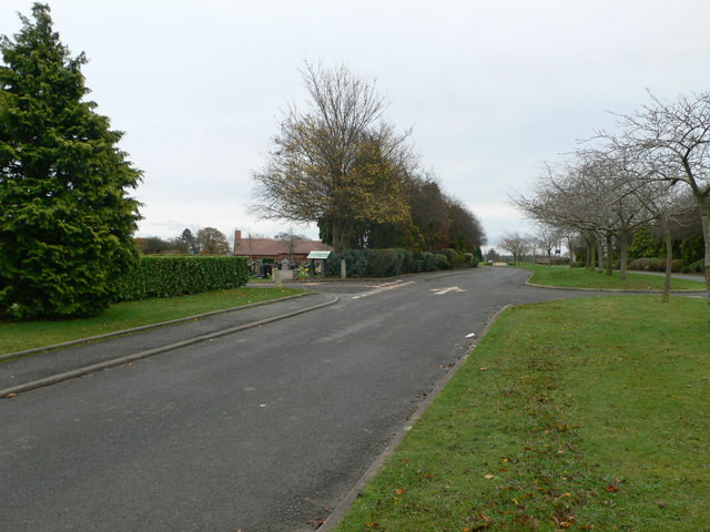
Jubilee Field is a picturesque area located in Herefordshire, England. Situated amidst the sweeping Downs and Moorland landscapes, it is known for its natural beauty and tranquil surroundings. Spanning a considerable area, the field is a haven for nature enthusiasts and those seeking a peaceful retreat.

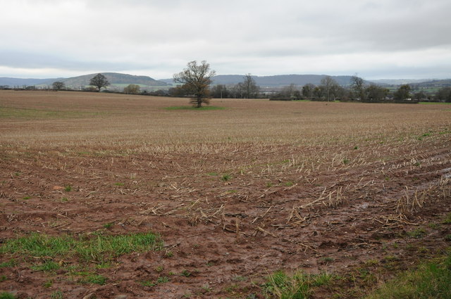
The field is characterized by its undulating terrain, with gentle slopes and rolling hills. Lush green grass covers the landscape, interspersed with patches of wildflowers, adding vibrant colors to the scene. The gentle breeze that blows across the field creates a soothing atmosphere, making it an ideal spot for relaxation and leisurely walks.

The wildlife in Jubilee Field is diverse and abundant, providing ample opportunities for nature lovers to observe and appreciate the local fauna. Visitors may spot various species of birds, including skylarks and meadow pipits, soaring through the sky. Additionally, the field is home to rabbits, foxes, and occasionally deer, adding to the charm of the natural environment.

The field offers stunning panoramic views of the surrounding Downs and Moorland, providing visitors with a breathtaking backdrop as they explore the area. On clear days, one can see for miles, with the undulating hills and valleys stretching as far as the eye can see. The ever-changing colors of the landscape, from vibrant greens in the summer to golden hues in the autumn, make Jubilee Field a visual delight throughout the year.

Overall, Jubilee Field in Herefordshire is a serene and idyllic location, offering visitors a chance to immerse themselves in the beauty of nature and experience the tranquility of the Downs and Moorland landscapes.

If you have any feedback on the listing, please let us know in the comments section below.

Jubilee Field Images

Images are sourced within 2km of 52.042464/-2.746829 or Grid Reference SO4838. Thanks to Geograph Open Source API. All images are credited.

The road into Hereford Cemetery and Crematorium
Arable land near Lower Breinton Arable land west of Lower Hill Farm, Lower Breinton.
Arable land near Lower Breinton
Arable land west of Lower Hill Farm, Lower Breinton.
Garden of Rest, Hereford Cemetery This area for the interment of cremated remains is close to the new crematorium.
Garden of Rest, Hereford Cemetery
This area for the interment of cremated remains is close to the new crematorium.
Hereford Cemetery To the west of the city centre, off the long Westfaling Street.
Hereford Cemetery
To the west of the city centre, off the long Westfaling Street.
White Horse Square houses, Hereford Viewed from the White Horse Street end.
White Horse Square houses, Hereford
Viewed from the White Horse Street end.
Chandos Street Methodist Church, Hereford On the corner of Chandos Street and White Horse Street.
Chandos Street Methodist Church, Hereford
On the corner of Chandos Street and White Horse Street.
Jubilee Almshouses, Hereford Late Victorian almshouses on the corner of Chandos Street and White Horse Street, opposite Chandos Street Methodist Church. <a title="https://www.geograph.org.uk/photo/3524955" href="https://www.geograph.org.uk/photo/3524955">Link</a>
A tablet <a title="https://www.geograph.org.uk/photo/3525031" href="https://www.geograph.org.uk/photo/3525031">Link</a> depicting stag and verderers shows the year 1887, the Golden Jubilee of Queen Victoria.
Jubilee Almshouses, Hereford
Late Victorian almshouses on the corner of Chandos Street and White Horse Street, opposite Chandos Street Methodist Church. Link A tablet Link depicting stag and verderers shows the year 1887, the Golden Jubilee of Queen Victoria.
Hereford Crematorium Chapel
Hereford Crematorium
Silver Birch in the cemetery
Hereford Cemetery Chapel Adjacent to Westfaling Street to the west of the city.
Hereford Cemetery Chapel
Adjacent to Westfaling Street to the west of the city.
Hereford Cemetery View north to the houses along Westfaling Street.
Hereford Cemetery
View north to the houses along Westfaling Street.
Hereford cemetery - damaged graves The fine treescape is in the next gridsquare to the south.
Hereford cemetery - damaged graves
The fine treescape is in the next gridsquare to the south.
Headstones at Hereford Crematorium
White Horse Square
White Horse Square
Emlyn Avenue, White Cross, Hereford
Wordsworth Road Descends from White Cross Hill to the Monument roundabout on the A438 King's Acre Road.
Wordsworth Road
Descends from White Cross Hill to the Monument roundabout on the A438 King's Acre Road.
White Cross housing By the roundabout at the top of Wordsworth Road.
White Cross housing
By the roundabout at the top of Wordsworth Road.
Show me another place!

Jubilee Field is located at Grid Ref: SO4838 (Lat: 52.042464, Lng: -2.746829)

Unitary Authority: County of Herefordshire

Police Authority: West Mercia

What 3 Words

///trend.hype.items. Near Belmont, Herefordshire

Related Wikis

Belmont Rural

Belmont Rural is a civil parish in Herefordshire, England. The population of the Civil Parish taken at the 2011 Census was 3,769. It is south-west of...

Belmont Abbey, Herefordshire

Belmont Abbey, in Herefordshire, England, is a Catholic Benedictine monastery that forms part of the English Benedictine Congregation. It stands on a small...

Warham, Herefordshire

Warham is a place in the English county of Herefordshire. It is situated about 3 km west of the city of Hereford, close to the north bank of the River...

The Hereford Academy

The Hereford Academy is a secondary school and sixth form located in Hereford, Herefordshire, England.It was known as Haywood High School in the late seventies...

Grafton, Herefordshire

Grafton is a village and civil parish in Herefordshire, England. The population of this civil parish was 258 at the 2011 census. The parish includes the...

Hereford Rowing Club

Hereford Rowing Club is a rowing club on the River Wye, based at 37 Greyfriars Avenue, Hereford, Herefordshire. == History == The club was founded in 1859...

Cider Museum, Hereford

The Cider Museum is a museum in Hereford, England, about the history of cider. The museum was set up as a Trust in the 1970s by Bertram Bulmer, Norman...

Hereford Barton railway station

Hereford Barton railway station was a station in Hereford, Herefordshire, England. == History == The station was opened on 2 January 1854 and closed on...

Nearby Amenities

Located within 500m of 52.042464,-2.746829
Mini Roundabout
Direction: clockwise
Lat/Long: 52.0427078/-2.7445302
Access: no
Barrier: yes
Description: Exit for fuel tankers only
Locked: yes
Lat/Long: 52.0415478/-2.7426428
Barrier: stile
Foot: yes
Lat/Long: 52.0423429/-2.7525754
Bus Stop
Northolme Road
Naptan AtcoCode: 2090A19630
Naptan NaptanCode: heramgjg
Operator: Yeomans
Route Ref: 75
Shelter: no
Lat/Long: 52.0416668/-2.7435001
Bus Stop
Haywood Turn
Naptan AtcoCode: 2090A19671
Naptan Bearing: NE
Naptan CommonName: Haywood Turn
Naptan Indicator: adj Home Farm
Naptan Landmark: o/s Home Farm
Naptan NaptanCode: heramgpt
Naptan PlusbusZoneRef: HEREFRD
Naptan Street: A465
Naptan Verified: no
Source: naptan_import
Lat/Long: 52.0392345/-2.7485042
Turning Circle
Lat/Long: 52.0391291/-2.7468959
Crossing
Crossing: traffic_signals
Lat/Long: 52.0415996/-2.7398729
Benjamin Park
Leisure: playground
Lat/Long: 52.0419639/-2.7437074
Car Wash
Waves
Addr City: Belmont
Addr Postcode: HR2 7XS
Addr Street: Abbotsmead Road
Brand: Waves
Brand Wikidata: Q81802122
Lat/Long: 52.0415657/-2.7407502
Bus Stop
Dorchester Way
Naptan AtcoCode: 2090A18800
Naptan NaptanCode: herajdpm
Operator: Yeomans
Route Ref: 75
Shelter: no
Lat/Long: 52.0426065/-2.7450541
Bus Stop
Stanbrook Road
Naptan AtcoCode: 2090A20461
Naptan NaptanCode: herapjdp
Operator: Yeomans
Route Ref: 75
Shelter: no
Lat/Long: 52.0412382/-2.7457992
Post Box
Stanbrook Road
Collection Times: Mo-Fr 11:15; Sa 11:15
Operator: Royal Mail
Ref: HR2 46
Lat/Long: 52.0412732/-2.7458802
Bus Stop
Haywood Turn
Naptan AtcoCode: 2090A19673
Naptan Bearing: SW
Naptan BusStopType: CUS
Naptan CommonName: Haywood Turn
Naptan Indicator: opp Home Farm
Naptan Landmark: o/s Lake Cottage
Naptan NaptanCode: heramgpw
Naptan Street: A465
Naptan Verified: no
Source: naptan_import
Lat/Long: 52.0389556/-2.749038
Atm
Tesco ATM
Currency GBP: yes
Network: Link
Operator: RBS
Lat/Long: 52.0419858/-2.74028
Leisure: playground
Max Age: 8
Operator: Herefordshire Council
Lat/Long: 52.0429806/-2.7493177
Library
Belmont Library
Addr City: Belmont
Addr Housename: Belmont Community Centre
Addr Postcode: HR2 7UQ
Addr Street: Eastholme Avenue
Operator: Herefordshire Council
Phone: +44 1432 383295
Lat/Long: 52.0412385/-2.7399707
Bus Stop
Tesco Store
Bench: yes
Bus: yes
Naptan AtcoCode: 2090A18323
Naptan NaptanCode: heragmwj
Public Transport: platform
Shelter: yes
Lat/Long: 52.0413416/-2.7405554
Generator Method: photovoltaic
Generator Output Electricity: yes
Generator Source: solar
Generator Type: solar_photovoltaic_panel
Location: roof
Power: generator
Lat/Long: 52.0456358/-2.7430026
Generator Method: photovoltaic
Generator Output Electricity: yes
Generator Source: solar
Generator Type: solar_photovoltaic_panel
Location: roof
Power: generator
Lat/Long: 52.0447195/-2.7416843
Generator Method: photovoltaic
Generator Output Electricity: yes
Generator Source: solar
Generator Type: solar_photovoltaic_panel
Location: roof
Power: generator
Lat/Long: 52.0440447/-2.7522643
Generator Method: photovoltaic
Generator Output Electricity: yes
Generator Source: solar
Generator Type: solar_photovoltaic_panel
Location: roof
Power: generator
Lat/Long: 52.0430005/-2.7526237
Generator Method: photovoltaic
Generator Output Electricity: yes
Generator Source: solar
Generator Type: solar_photovoltaic_panel
Location: roof
Power: generator
Lat/Long: 52.0437742/-2.7515642
Generator Method: photovoltaic
Generator Output Electricity: yes
Generator Source: solar
Generator Type: solar_photovoltaic_panel
Location: roof
Power: generator
Lat/Long: 52.0401282/-2.7485052
Generator Method: photovoltaic
Generator Output Electricity: yes
Generator Source: solar
Generator Type: solar_photovoltaic_panel
Location: roof
Power: generator
Lat/Long: 52.0408376/-2.7496585
Generator Method: photovoltaic
Generator Output Electricity: yes
Generator Source: solar
Generator Type: solar_photovoltaic_panel
Location: roof
Power: generator
Lat/Long: 52.040341/-2.7488941
Generator Method: photovoltaic
Generator Output Electricity: yes
Generator Source: solar
Generator Type: solar_photovoltaic_panel
Location: roof
Power: generator
Lat/Long: 52.0419653/-2.7426606
Generator Method: photovoltaic
Generator Output Electricity: yes
Generator Source: solar
Generator Type: solar_photovoltaic_panel
Location: roof
Power: generator
Lat/Long: 52.0451154/-2.7415288
Generator Method: photovoltaic
Generator Output Electricity: yes
Generator Source: solar
Generator Type: solar_photovoltaic_panel
Location: roof
Power: generator
Lat/Long: 52.0449818/-2.7418023
Generator Method: photovoltaic
Generator Output Electricity: yes
Generator Source: solar
Generator Type: solar_photovoltaic_panel
Location: roof
Power: generator
Lat/Long: 52.0448036/-2.7421322
Generator Method: photovoltaic
Generator Output Electricity: yes
Generator Source: solar
Generator Type: solar_photovoltaic_panel
Location: roof
Power: generator
Lat/Long: 52.0452878/-2.7438797
Generator Method: photovoltaic
Generator Output Electricity: yes
Generator Source: solar
Generator Type: solar_photovoltaic_panel
Location: roof
Power: generator
Lat/Long: 52.0452614/-2.7438502
Generator Method: photovoltaic
Generator Output Electricity: yes
Generator Source: solar
Generator Type: solar_photovoltaic_panel
Location: roof
Power: generator
Lat/Long: 52.0398848/-2.7473076
Generator Method: photovoltaic
Generator Output Electricity: yes
Generator Source: solar
Generator Type: solar_photovoltaic_panel
Location: roof
Power: generator
Lat/Long: 52.041613/-2.7450344
Generator Method: photovoltaic
Generator Output Electricity: yes
Generator Source: solar
Generator Type: solar_photovoltaic_panel
Location: roof
Power: generator
Lat/Long: 52.0421302/-2.7481484
Generator Method: photovoltaic
Generator Output Electricity: yes
Generator Source: solar
Generator Type: solar_photovoltaic_panel
Location: roof
Power: generator
Lat/Long: 52.042042/-2.7480841
Generator Method: photovoltaic
Generator Output Electricity: yes
Generator Source: solar
Generator Type: solar_photovoltaic_panel
Location: roof
Power: generator
Lat/Long: 52.0432612/-2.7502057
Charging Station
Capacity: 4
Motorcar: yes
Operator: Pod Point
Operator Wikidata: Q42888154
Lat/Long: 52.0419527/-2.7404671
Crossing
Lat/Long: 52.0418828/-2.7402199
Bicycle Rental
Capacity: 5
Name Signed: no
Network: Beryl - Hereford
Official Name: Dorchester Way
Operator: Beryl
Operator Wikidata: Q106575369
Payment App: yes
Payment App Android: cc.beryl.basis
Payment App Ios: 1386768364
Payment Cash: no
Payment Credit Cards: no
Payment Cryptocurrencies: no
Payment Debit Cards: no
Payment Electronic Purses: no
Ref Gbfs: beryl_hereford:2275
Lat/Long: 52.0431328/-2.7495661
Parcel Locker
Brand: InPost
Brand Wikidata: Q3182097
Operator: InPost
Parcel Mail In: yes
Parcel Pickup: yes
Source: local_knowledge
Lat/Long: 52.0423922/-2.7406765
AED
Defibrillator
Emergency: defibrillator
Note: Inside Tesco store, customer service desk.
Lat/Long: 52.0420088/-2.7402119
Post Box
Operator: Royal Mail
Post Box Type: pillar
Lat/Long: 52.0401661/-2.740585
Addr Housenumber: 26
Lat/Long: 52.0414356/-2.7434622
Addr Housenumber: 28
Lat/Long: 52.0414651/-2.7433396
Addr Housenumber: 24
Lat/Long: 52.0413609/-2.7436116
Addr Housenumber: 10
Lat/Long: 52.0412547/-2.7440564
Generator Method: photovoltaic
Generator Output Electricity: yes
Generator Source: solar
Generator Type: solar_photovoltaic_panel
Location: roof
Power: generator
Lat/Long: 52.0441883/-2.7518057
Generator Method: photovoltaic
Generator Output Electricity: yes
Generator Source: solar
Generator Type: solar_photovoltaic_panel
Location: roof
Power: generator
Lat/Long: 52.043672/-2.7510641
Generator Method: photovoltaic
Generator Output Electricity: yes
Generator Source: solar
Generator Type: solar_photovoltaic_panel
Location: roof
Power: generator
Lat/Long: 52.0450483/-2.7416554
Generator Method: photovoltaic
Generator Output Electricity: yes
Generator Source: solar
Generator Type: solar_photovoltaic_panel
Location: roof
Power: generator
Lat/Long: 52.044885/-2.742212
The data included in this document is from www.openstreetmap.org. The data is made available under ODbL.

Have you been to Jubilee Field?

Leave your review of Jubilee Field below (or comments, questions and feedback).