Gairs Muir

Downs, Moorland in Midlothian

Scotland

Gairs Muir

B709 near Dewar
B709 near Dewar Credit: Steven Brown

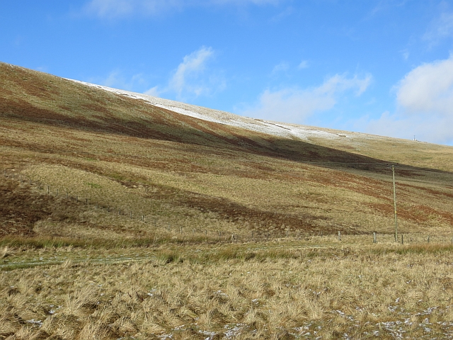
Gairs Muir is a picturesque area located in Midlothian, Scotland. Situated amidst the stunning Scottish countryside, it is renowned for its sprawling downs and moorland. The landscape of Gairs Muir is characterized by vast open spaces, rolling hills, and heather-covered moors, which create a breathtaking and tranquil environment.

The downs of Gairs Muir offer a unique experience for nature enthusiasts and outdoor adventurers. These expansive grassy areas are perfect for activities such as walking, hiking, and picnicking, providing visitors with ample opportunities to immerse themselves in the beauty of the surroundings. The undulating terrain adds an element of challenge for those seeking a more adventurous experience.

The moorland of Gairs Muir is a haven for wildlife, with its rich biodiversity attracting a variety of species. Birdwatchers will delight in the chance to spot rare birds such as the golden eagle, red grouse, and peregrine falcon. The moorland is also home to numerous species of mammals, including red deer, mountain hares, and Scottish wildcats, making it a haven for wildlife enthusiasts.

Gairs Muir's natural beauty and tranquility make it an ideal destination for those looking to escape the hustle and bustle of city life. Whether it's a leisurely stroll through the downs or an adrenaline-fueled hike across the moorland, visitors are sure to be captivated by the stunning scenery and the sense of serenity that Gairs Muir offers.

If you have any feedback on the listing, please let us know in the comments section below.

Gairs Muir Images

Images are sourced within 2km of 55.732745/-3.0450851 or Grid Reference NT3449. Thanks to Geograph Open Source API. All images are credited.

B709 near Dewar
B709 near Dewar
B709 near Dewar
B709 near Dewar
B709 near Dewar
B709 near Dewar
Farm track near Garvald Law
B709 near Garvald Lodge
Sheepfold Sheepfold near Dewar passed on the way towards Blackhope Scar.  Most structures today referred to as sheepfolds are ancient dry stone semicircles, with no roof and are one of the oldest types of livestock enclosures.
Sheepfold
Sheepfold near Dewar passed on the way towards Blackhope Scar. Most structures today referred to as sheepfolds are ancient dry stone semicircles, with no roof and are one of the oldest types of livestock enclosures.
Club run, B709, Midlothian Heading up the long steady climb to a pass in the Moorfoot Hills.
Club run, B709, Midlothian
Heading up the long steady climb to a pass in the Moorfoot Hills.
B709, Dewar A long straight road, high in the Moorfoot Hills.
B709, Dewar
A long straight road, high in the Moorfoot Hills.
Dewar Hill Steep heather slopes above the B709.
Dewar Hill
Steep heather slopes above the B709.
B709, Dewar Approaching the pass at Dewar Gill.
B709, Dewar
Approaching the pass at Dewar Gill.
Track, Gairs Muir Track up into the Moorfoot Hills from Dewar.
Track, Gairs Muir
Track up into the Moorfoot Hills from Dewar.
Gairs Muir Grassy moorland and rough grazing between Garvald Lodge and Dewar, Moorfoot Hills.
Gairs Muir
Grassy moorland and rough grazing between Garvald Lodge and Dewar, Moorfoot Hills.
Grouse butts, Ladyside A dusting of snow shows up any changes or disturbance of the heather.
Grouse butts, Ladyside
A dusting of snow shows up any changes or disturbance of the heather.
Grouse butts on Peatrig Hill Looking south from near Raeshaw, the butts show up after a night of snow  showers. For a similar picture earlier in the year by Richard Webb see <a href="https://www.geograph.org.uk/photo/3886473">NT3649 : Grouse butts, Ladyside</a>.
Grouse butts on Peatrig Hill
Looking south from near Raeshaw, the butts show up after a night of snow showers. For a similar picture earlier in the year by Richard Webb see NT3649 : Grouse butts, Ladyside.
The B709 in the valley of the Dewar Burn Looking north towards Heriot and the A7, with the slopes of Garvald Law on the left.
The B709 in the valley of the Dewar Burn
Looking north towards Heriot and the A7, with the slopes of Garvald Law on the left.
The Dewar Burn valley Looking west to the slopes of Garvald Hill, with a circular sheep fold camouflaged by the snow and heather.
The Dewar Burn valley
Looking west to the slopes of Garvald Hill, with a circular sheep fold camouflaged by the snow and heather.
Sheep fold at Wolf Cleugh At the foot of Peat Rig.
Sheep fold at Wolf Cleugh
At the foot of Peat Rig.
Tracks up Peat Rig With Wolf Cleugh on the right.
Tracks up Peat Rig
With Wolf Cleugh on the right.
Show me another place!

Gairs Muir is located at Grid Ref: NT3449 (Lat: 55.732745, Lng: -3.0450851)

Unitary Authority: The Scottish Borders

Police Authority: The Lothians and Scottish Borders

What 3 Words

///extensive.majority.older. Near Gorebridge, Midlothian

Related Wikis

Dewar, Scottish Borders

Dewar is a village by the Dewar Burn and Peatrig Hill, in the Scottish Borders area of Scotland. Places nearby include Allanshaugh, Borthwick Hall, Fountainhall...

Peatrig Hill

Peatrig Hill is a minor hill in Scotland, located about 15 km south-southeast of Edinburgh. One of the Moorfoot Hills, it is located in the parish of Heriot...

Garvald, Scottish Borders

Garvald (Scots: Garvit) is a hamlet on the B7007, near Dewar, by the Dewar Burn, in the Moorfoot Hills, in the Scottish Borders area of Scotland, in the...

Moorfoot Hills

The Moorfoot Hills are a range of hills south of Edinburgh in east central Scotland, one of the ranges which collectively form the Southern Uplands....

Have you been to Gairs Muir?

Leave your review of Gairs Muir below (or comments, questions and feedback).