Bellfield Wood

Downs, Moorland in Peeblesshire

Scotland

Bellfield Wood

Old Milestone by the A703, Eddleston Parish Peebles by the A703, in parish of Eddleston (Peebles District), North of Eddleston, near turning for Scots Pine Tea Shop, East side of road.

Inscription reads:- : PEEBLESSHIRE / PEEBLES / 5 MILES {pointing hand} / PENICUIK / {pointing hand} 8 MILES / EDINBURGH / G.P.O. / {pointing hand} 17⅞ MILES :

Surveyed

Milestone Society National ID: BD_PBPK05.
Old Milestone by the A703, Eddleston Parish Credit: David Thom

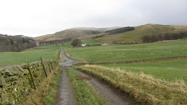
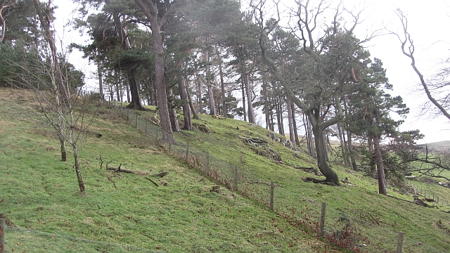
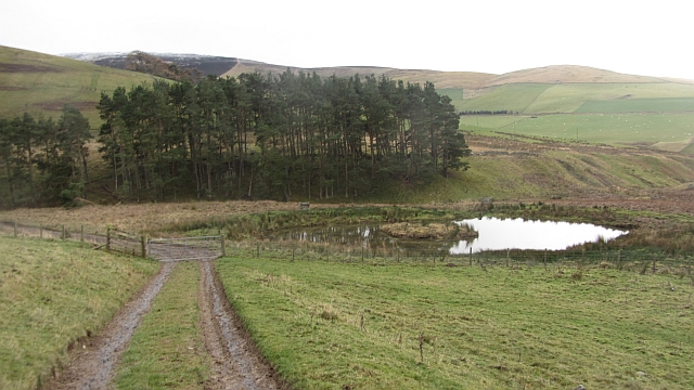
Bellfield Wood is a captivating natural area situated in Peeblesshire, Scotland. Covering a vast expanse of land, this enchanting woodland boasts a diverse range of features including downs and moorland.

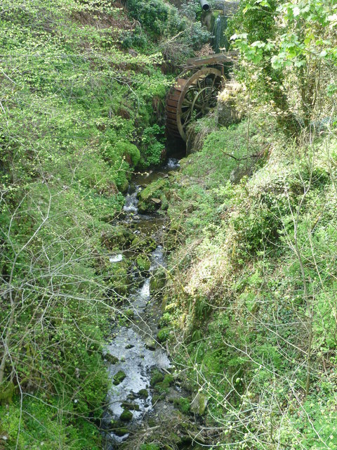
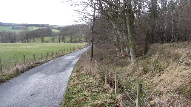
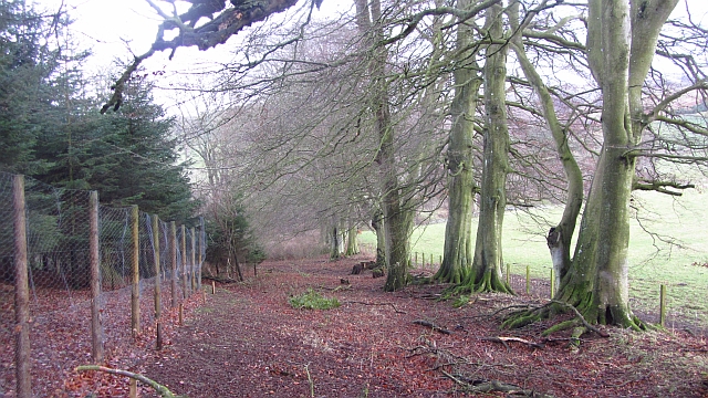
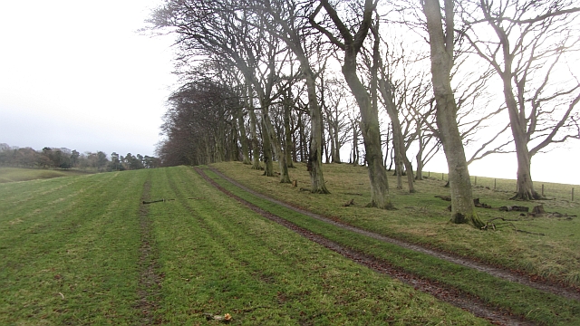
The wood is characterized by its lush greenery, with towering trees creating a dense canopy overhead. The variety of tree species found within Bellfield Wood is truly astounding, including oak, birch, beech, and Scots pine, among others. This rich tapestry of vegetation provides a haven for numerous bird species, making it a popular spot for birdwatching enthusiasts.

As one explores the wood, they will encounter rolling downs that add to the picturesque scenery. These gentle slopes offer breathtaking views of the surrounding landscape, with vast stretches of moorland visible in the distance. The moorland itself is a blend of heather, grasses, and wildflowers, creating a vibrant and ever-changing mosaic of colors throughout the seasons.

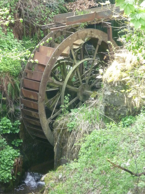
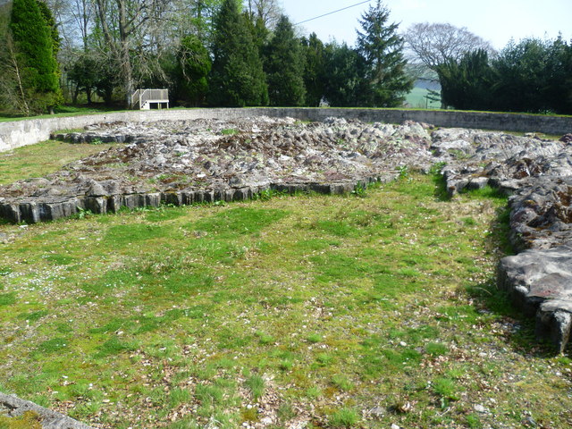
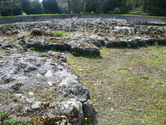
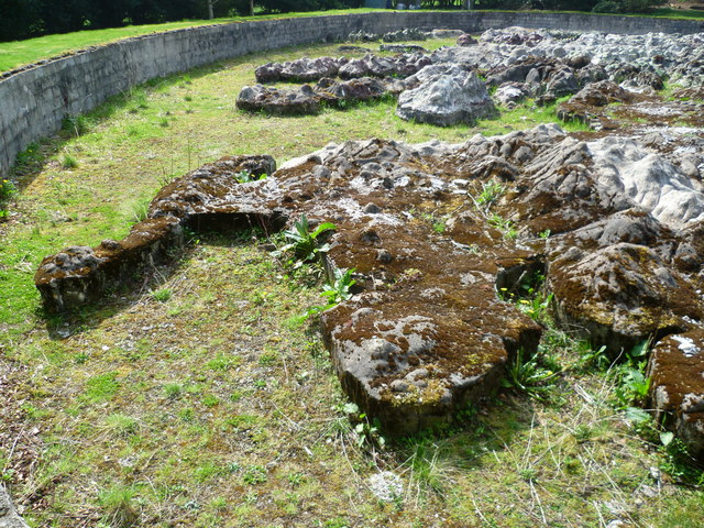
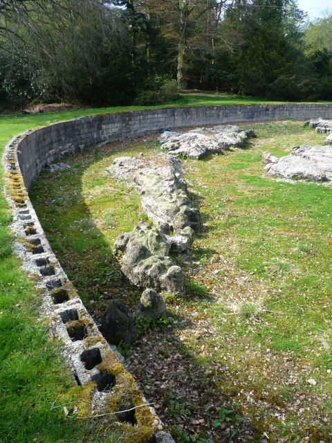
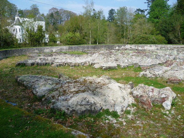
Bellfield Wood is not only a haven for flora and fauna but also holds historical significance. The ancient ruins of a castle can be found nestled within the wood, serving as a reminder of the rich past that permeates this area.

Visitors to Bellfield Wood can partake in a range of activities, from leisurely walks along well-maintained trails to more adventurous pursuits such as orienteering or mountain biking. There are also designated picnic areas, allowing visitors to relax and soak in the tranquil atmosphere.

In essence, Bellfield Wood is a natural gem, offering a harmonious blend of woodlands, downs, and moorland. Its beauty, biodiversity, and historical charm make it a must-visit destination for nature lovers and history enthusiasts alike.

If you have any feedback on the listing, please let us know in the comments section below.

Bellfield Wood Images

Images are sourced within 2km of 55.715296/-3.2011541 or Grid Reference NT2447. Thanks to Geograph Open Source API. All images are credited.

Old Milestone by the A703, Eddleston Parish Peebles by the A703, in parish of Eddleston (Peebles District), North of Eddleston, near turning for Scots Pine Tea Shop, East side of road.

Inscription reads:- : PEEBLESSHIRE / PEEBLES / 5 MILES {pointing hand} / PENICUIK / {pointing hand} 8 MILES / EDINBURGH / G.P.O. / {pointing hand} 17⅞ MILES :

Surveyed

Milestone Society National ID: BD_PBPK05.
Old Milestone by the A703, Eddleston Parish
Peebles by the A703, in parish of Eddleston (Peebles District), North of Eddleston, near turning for Scots Pine Tea Shop, East side of road. Inscription reads:- : PEEBLESSHIRE / PEEBLES / 5 MILES {pointing hand} / PENICUIK / {pointing hand} 8 MILES / EDINBURGH / G.P.O. / {pointing hand} 17⅞ MILES : Surveyed Milestone Society National ID: BD_PBPK05.
Barony Castle Hotel, Eddleston
Waterwheel on the Dean Burn
Old waterwheel at Barony Castle
Barony Castle map of Scotland, Eddleston When I heard that a topographical map of Scotland, carved in stone by Polish army veterans, existed in the grounds of the Barony Castle Hotel, I expected to find something the size of a dining table. I was taken aback on discovering the scale of this massive sculpture which is in fact made of moulded concrete. The viewing platform cannot do it justice until it is raised by another thirty feet at least to gain a good overview of the whole. Those who want the bird's eye view can find it on GoogleEarth at NT 23656 47179. Ground-level photographs fail to deliver the overall visual impact of the map on the beholder. This one is taken standing east of Caithness, looking south across the Moray Firth. For more about this remarkablea artefact, see <span class="nowrap"><a title="http://www.mapascotland.org/" rel="nofollow ugc noopener" href="http://www.mapascotland.org/">Link</a><img style="margin-left:2px;" alt="External link" title="External link - shift click to open in new window" src="https://s1.geograph.org.uk/img/external.png" width="10" height="10"/></span>
Barony Castle map of Scotland, Eddleston
When I heard that a topographical map of Scotland, carved in stone by Polish army veterans, existed in the grounds of the Barony Castle Hotel, I expected to find something the size of a dining table. I was taken aback on discovering the scale of this massive sculpture which is in fact made of moulded concrete. The viewing platform cannot do it justice until it is raised by another thirty feet at least to gain a good overview of the whole. Those who want the bird's eye view can find it on GoogleEarth at NT 23656 47179. Ground-level photographs fail to deliver the overall visual impact of the map on the beholder. This one is taken standing east of Caithness, looking south across the Moray Firth. For more about this remarkablea artefact, see LinkExternal link
Barony Castle map of Scotland, Forth Estuary and Fife For an explanation of the map, see <span class="nowrap"><a title="https://en.wikipedia.org/wiki/Great_Polish_Map_of_Scotland" rel="nofollow ugc noopener" href="https://en.wikipedia.org/wiki/Great_Polish_Map_of_Scotland">Link</a><img style="margin-left:2px;" alt="External link" title="External link - shift click to open in new window" src="https://s1.geograph.org.uk/img/external.png" width="10" height="10"/></span>
Barony Castle map of Scotland, Forth Estuary and Fife
For an explanation of the map, see LinkExternal link
Barony Castle map of Scotland, Galloway
Barony Castle map of Scotland, Outer Hebrides
Barony Castle map of Scotland, Isle of Lewis
Row of Cottages at Harcus North of Eddleston in Peeblesshire.
Row of Cottages at Harcus
North of Eddleston in Peeblesshire.
The church, Eddleston Looking over what looks like the site of a demolished house towards the church.
The church, Eddleston
Looking over what looks like the site of a demolished house towards the church.
Boreland An untarred farm road soon joins the tarred main access for the farm. There is a dusting on Dundreich in the background.
Boreland
An untarred farm road soon joins the tarred main access for the farm. There is a dusting on Dundreich in the background.
Road to Boreland A farm access road, it passes The Grove,a deciduous woodland which contained a calling nuthatch.
Road to Boreland
A farm access road, it passes The Grove,a deciduous woodland which contained a calling nuthatch.
The Grove Woodland, mostly deciduous with oaks beyond the conifers, left.
The Grove
Woodland, mostly deciduous with oaks beyond the conifers, left.
Strip wood, Boreland A beech strip.
Strip wood, Boreland
A beech strip.
Dog Knowes Pine wood on a craggy hillside.
Dog Knowes
Pine wood on a craggy hillside.
Flight pool, Longcote Artificial pool for attracting wildfowl.
Flight pool, Longcote
Artificial pool for attracting wildfowl.
Show me another place!

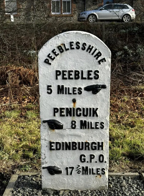
Bellfield Wood is located at Grid Ref: NT2447 (Lat: 55.715296, Lng: -3.2011541)

Unitary Authority: The Scottish Borders

Police Authority: The Lothians and Scottish Borders

What 3 Words

///wired.hopes.input. Near Peebles, Scottish Borders

Nearby Locations

Eddleston Bellfield Wood

Related Wikis

Eddleston

Eddleston (Scottish Gaelic: Baile Ghille Mhoire) is a small village and civil parish in the Scottish Borders area of Scotland. It lies 4 miles (6.4 km...

Eddleston railway station

Eddleston railway station served the village of Eddleston, Scottish Borders, Scotland from 1855 to 1962 on the Peebles Railway. == History == The station...

Darnhall Mains

Darnhall Mains is a farm and settlement off the A703, near Eddleston and the Eddleston Water in the Scottish Borders area of Scotland, in the former Peeblesshire...
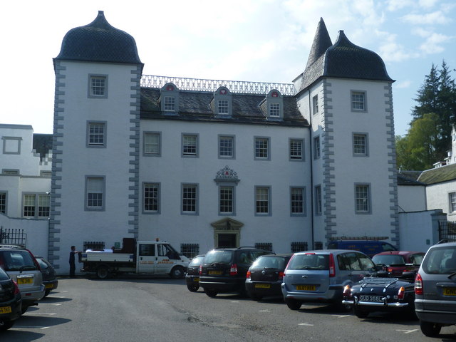
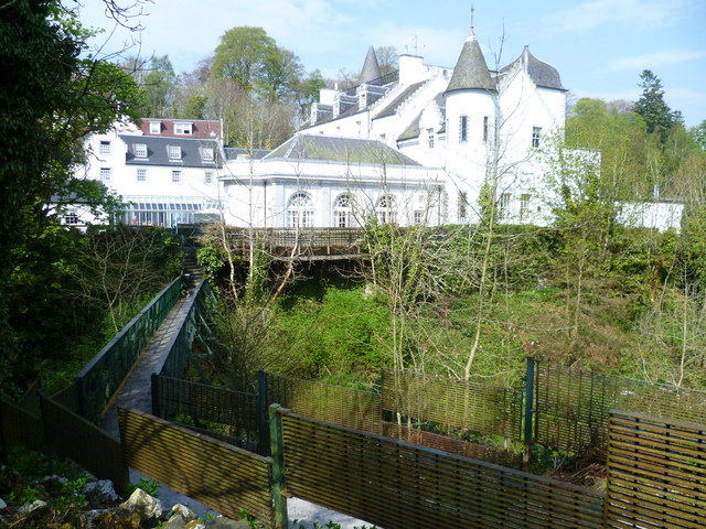
Black Barony

Barony Castle, also and formerly known as Black Barony, and Darnhall, is a historic house at Eddleston in the Scottish Borders area of Scotland. The house...

Great Polish Map of Scotland

The Great Polish Map of Scotland is a large (50 m x 40 m) three-dimensional, outdoor concrete scale model of Scotland, located in the grounds of the Barony...

Milkieston Rings

Milkieston Rings is a prehistoric site, a hillfort near the village of Eddleston and about 3 miles (5 km) north of Peebles, in the Scottish Borders, Scotland...

Northshield Rings

Northshield Rings is a prehistoric site, a hillfort near the village of Eddleston and about 6 miles (10 km) north of Peebles, in the Scottish Borders,...

Earlyvale Gate railway station

Earlyvale Gate railway station served the Dundas family residence in Earlyvale, Scottish Borders, Scotland for 8 months (June 1856 - February 1857) on...

Nearby Amenities

Located within 500m of 55.715296,-3.2011541
Restaurant
Horse Shoe Inn
Addr Postcode: EH45 8QP
Addr Street: Bellfield Road
Fhrs Id: 1106103
Source Addr: FHRS Open Data
Wikidata: Q56606269
Lat/Long: 55.7124079/-3.2063504
Telephone
Booth: K6
Covered: booth
Lat/Long: 55.712376/-3.2068176
Horse Shoe Inn Hotel
Tourism: hotel
Lat/Long: 55.7123079/-3.2063623
Bus Stop
Horseshoe Inn
Bus: yes
Naptan AtcoCode: 6900970
Naptan Bearing: N
Naptan CommonName: Horseshoe Inn
Naptan Indicator: opp
Naptan NaptanCode: 72725357
Naptan Street: Old Manse Road
Naptan Verified: no
Operator: Scottish Borders Council
Public Transport: platform
Ref: 6900970
Source: NaPTAN
Lat/Long: 55.7121417/-3.2066747
Bus Stop
Horseshoe Inn
Bus: yes
Naptan AtcoCode: 6900971
Naptan Bearing: S
Naptan CommonName: Horseshoe Inn
Naptan Indicator: o/s
Naptan NaptanCode: 72725353
Naptan Street: A703
Operator: Scottish Borders Council
Public Transport: platform
Ref: 6900971
Source: NaPTAN
Lat/Long: 55.7121756/-3.2064436
Noexit: yes
Lat/Long: 55.7118048/-3.2060941
Give Way
Direction: forward
Lat/Long: 55.7117138/-3.2059333
Entrance: yes
Lat/Long: 55.7125225/-3.2047597
Entrance: yes
Lat/Long: 55.7125255/-3.2049391
Give Way
Direction: backward
Lat/Long: 55.7132183/-3.2048549
Give Way
Direction: forward
Lat/Long: 55.7149635/-3.2057843
Addr Street: Bellfield Road
Lat/Long: 55.7137565/-3.2048179
Barrier: bollard
Lat/Long: 55.7135673/-3.2062054
The data included in this document is from www.openstreetmap.org. The data is made available under ODbL.

Have you been to Bellfield Wood?

Leave your review of Bellfield Wood below (or comments, questions and feedback).